
-
Arctic Vegetation Plots, Prudhoe Bay ArcSEES Road Study, Lake Colleen, Alaska, 2014 recent views
This dataset provides environmental, soil, and vegetation data collected from study plots in the vicinity of Lake Colleen off the Spine Road at Prudhoe Bay, Alaska, during... -
Delta-X: UAVSAR L1 Single Look Complex (SLC) Stack Products, MRD, Louisiana, 2021 recent views
This dataset contains UAVSAR Level 1 (L1) Single Look Complex (SLC) stack products for Delta-X flight lines acquired during 2021-03-27 to 2021-04-18 (spring) and 2021-09-03 to... -
ABoVE: Surface Water Extent, Boreal and Tundra Regions, North America, 1991-2011 recent views
This data set provides the location and extent of surface water (open water not including vegetated wetlands) for the entire Boreal and Tundra regions of North America for three... -
ABoVE: Rain-on-Snow Frequency and Distribution during Cold Seasons, Alaska, 2003-2016 NGDA recent views
This dataset provides maps of rain-on-snow (ROS) events across Alaska for the individual months of November to March 2002-2011 and November to March 2012-2016, and annual water... -
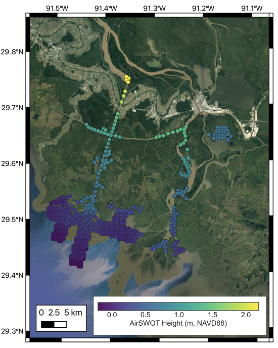
Pre-Delta-X: L3 AirSWOT-derived Water Level Profiles, Wax Lake Outlet, LA, USA, 2015 recent views
This dataset contains water level profiles generated from the AirSWOT data collected in the Atchafalaya Basin in Southern Louisiana, USA, within the Mississippi River Delta... -
Arctic Vegetation Plots in Northern NWT and YT, Canada, 1965-1966 recent views
This dataset provides vegetation, soil, and plot characteristics for 154 study plots located at three sites across the Richardson Mountains, Northwest Territories (NWT), and the... -
ABoVE: Dall Sheep Lamb Recruitment and Climate Data, Alaska and NW Canada, 2000-2015 NGDA recent views
This dataset contains estimated annual average Dall sheep (Ovis dalli dalli) lamb-to-ewe ratios for each year from 2000-2015 across the full species range in Alaska and... -
Delta-X: AirSWOT Level 1B Interferogram Products in Radar Coordinates, 2021 recent views
This dataset contains AirSWOT interferogram products collected during the 2021 Delta-X Campaign over the Atchafalaya and Terrebonne Basins of the Mississippi River Delta,... -
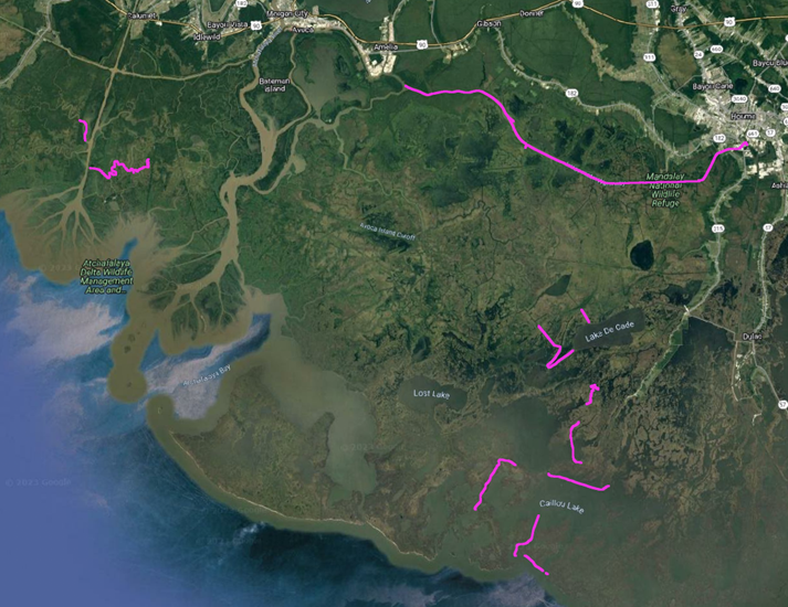
Pre-Delta-X: River Discharge Channel Surveys across Atchafalaya Basin, LA, USA, 2016 recent views
This dataset provides river discharge measurements collected at selected locations across the Atchafalaya River Basin, within the Mississippi River Delta (MRD) floodplain in... -
ABoVE: Last Day of Spring Snow, Alaska, USA, and Yukon Territory, Canada, 2000-2016 NGDA recent views
This dataset provides the last day of spring snow cover for most of Alaska and the Yukon Territory for 2000 through 2016. The data are based on the MODIS daily snow cover... -
ABoVE: Passive Microwave-derived Annual Snowoff Date Maps, 1988-2018 recent views
This dataset provides annual maps of the snowoff (SO) date from 1988-2018 across Alaska and parts of Far East Russia and northwest Canada at a resolution of 6.25 km. SO date is... -
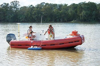
Delta-X: In-situ Water Surface Elevation, MRD, Louisiana, USA, 2021 recent views
This dataset contains water surface elevations collected from boat surveys performed on August 24 and September 22-25, 2021, across the Atchafalaya and Terrebonne basins in the... -
Pre-Delta-X: Spectral Reflectance of Water Surface, Atchafalaya Basin, LA, USA, 2016 recent views
This dataset provides measurements of in situ remote-sensing reflectance (Rrs; per steradian) of surface water across Atchafalaya Basin, southern coastal Louisiana, USA within... -
LBA-ECO LC-01 Hydrography, Morphology, Edaphology Maps, Northern Ecuadorian Amazon recent views
This data set provides map images of hydrographic, morphologic, and edaphic features for the northern Amazon Basin in eastern Ecuador. The hydrographic data are available at two... -
LBA-ECO ND-01 Watershed Deforestation from Landsat TM Series, Rondonia, Brazil: 1999 recent views
This data set provides estimates of watershed deforestation, as a proportion of the total area of watersheds, in Rondonia, Brazil for 1999. Deforestation maps were determined... -
ABoVE: Lake and Wetland Classification from L-band SAR, Alaska and Canada, 2017-2019 recent views
This dataset contains a high-resolution land cover classification focused on water and wetland vegetation classes over three NASA ABoVE Campaign regions: Yukon Flats, Alaska,... -
Delta-X: AirSWOT L3 Water Surface Elevations, MRD, Louisiana, 2021 recent views
This dataset contains water surface elevations at selected point locations generated from the AirSWOT data collected during the Spring and Fall 2021 Delta-X deployments over the... -
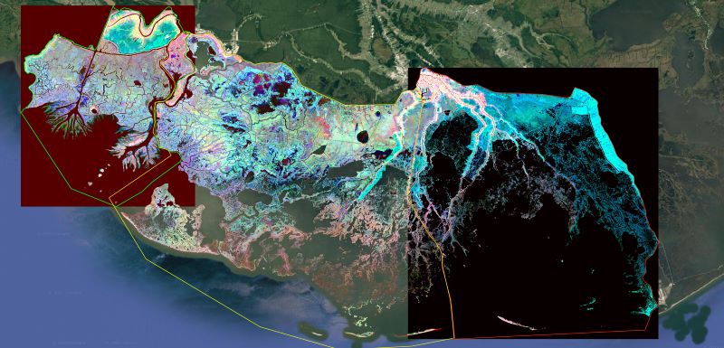
Delta-X: Ecogeomorphic Cell Products across the MRD, LA, USA, 2021 recent views
This product delineates the Mississippi River Delta (MRD) landscape into distinct ecogeomorphic cells, which are small contiguous areas of land with similar ecological and... -
LBA-ECO LC-04 THMB Model Simulations for the Amazon and Tocantins Basins: 1939-1998 recent views
The model output data provided were generated by the THMB 1.2 (Terrestrial Hydrology Model with Biogeochemistry) model which simulates the flow of water through groundwater... -
LBA-ECO TG-09 Soil Isotopic C, N, H2O, and N2O Data, Tapajos National Forest, Brazil recent views
This data set reports the results of carbon, nitrogen, and oxygen isotopic analyses of soil, soil water, and N2O soil gas samples; total soil carbon and nitrogen concentrations;...

Official websites use .gov
A
.gov website belongs to an official government
organization in the United States.
Secure .gov websites use HTTPS
A
lock (
) or https:// means you’ve safely connected to
the .gov website. Share sensitive information only on official,
secure websites.