
-
GLDAS Noah Land Surface Model L4 monthly 0.25 x 0.25 degree V2.1 (GLDAS_NOAH025_M) at GES DISC recent views
NASA Global Land Data Assimilation System Version 2 (GLDAS-2) has three components: GLDAS-2.0, GLDAS-2.1, and GLDAS-2.2. GLDAS-2.0 is forced entirely with the Princeton... -
GLDAS Catchment Land Surface Model L4 daily 0.25 x 0.25 degree GRACE-DA1 V2.2 (GLDAS_CLSM025_DA1_D) at GES DISC recent views
NASA Global Land Data Assimilation System Version 2 (GLDAS-2) has three components: GLDAS-2.0, GLDAS-2.1, and GLDAS-2.2. GLDAS-2.0 is forced entirely with the Princeton... -
World Glacier Inventory, Version 1 recent views
The World Glacier Inventory (WGI) contains information for over 130,000 glaciers, or about 85% of the total estimated number of glaciers. Inventory parameters include geographic... -
Global Land Cover Characterization Program recent views
The Global Land Cover Characterization Project was established to meet science data requirements identified by the International Geosphere and Biosphere Programme (IGBP), and... -
FLDAS Noah Land Surface Model L4 Global Monthly 0.1 x 0.1 degree (MERRA-2 and CHIRPS) V001 (FLDAS_NOAH01_C_GL_M) at GES DISC recent views
This dataset contains a series of land surface parameters simulated from the Noah 3.6.1 model in the Famine Early Warning Systems Network (FEWS NET) Land Data Assimilation... -
JPL GRACE and GRACE-FO Mascon Ocean, Ice, and Hydrology Equivalent Water Height Coastal Resolution Improvement (CRI) Filtered Release 06.3 Version 04 recent views
This dataset contains gridded monthly global water storage/height anomalies relative to a time-mean, derived from GRACE and GRACE-FO and processed at JPL using the Mascon... -
GLDAS Noah Land Surface Model L4 monthly 1.0 x 1.0 degree V2.1 (GLDAS_NOAH10_M) at GES DISC recent views
NASA Global Land Data Assimilation System Version 2 (GLDAS-2) has three components: GLDAS-2.0, GLDAS-2.1, and GLDAS-2.2. GLDAS-2.0 is forced entirely with the Princeton... -
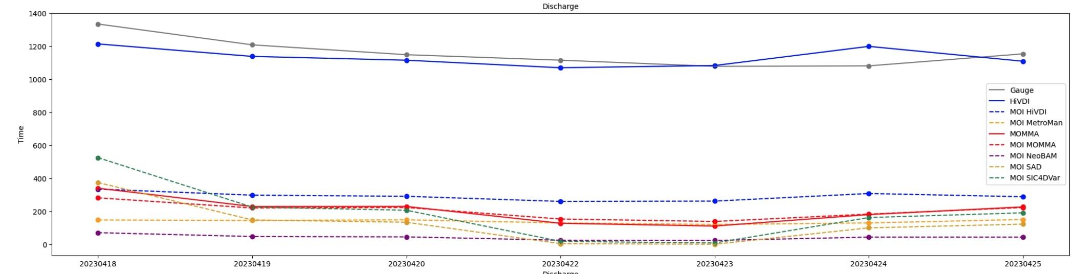
SWOT Sword of Science River Discharge Products Version 1 recent views
The SWOT Sword of Science River Discharge Products dataset from the Surface Water and Ocean Topography (SWOT) mission and produced by the Discharge Algorithm Working Group... -
MODIS/Aqua+Terra Global Flood Product L3 NRT 250m 1-day CS GeoTIFF NGDA recent views
The MODIS/Aqua+Terra Global Flood Product L3 Near Real Time (NRT) 250m 1-day CS GeoTIFF Product (MCDWD_L3_F1C_NRT) (beta) provides daily maps of flooding globally. The Global... -
USGS Digital Orthophoto Quadrangles recent views
A Digital Orthophoto Quadrangle (DOQ) is a computer-generated image of an aerial photograph in which the image displacement caused by terrain relief and camera tilt has been... -
SWOT Level 2 Lake Single-Pass Vector Data Product, Version 2.0 recent views
The SWOT Level 2 Lake Single-Pass Vector Data Product from the Surface Water Ocean Topography (SWOT) mission provides water surface elevation, area, storage change derived from... -
OPERA Dynamic Surface Water Extent from Sentinel-1 (Version 1) recent views
This dataset contains Level-3 Dynamic OPERA Surface Water Extent from Sentinal-1 (DSWx-S1) product version 1. DSWx-S1 provides near-global geographical mapping of surface water... -
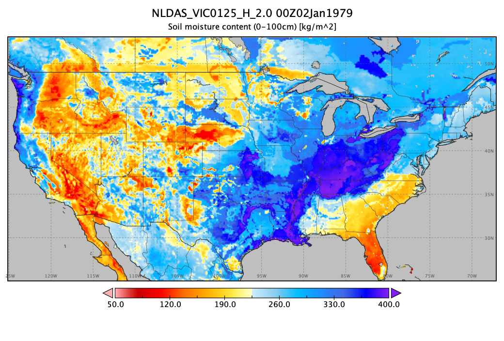
NLDAS VIC Land Surface Model L4 Hourly 0.125 x 0.125 degree V2.0 (NLDAS_VIC0125_H) at GES DISC recent views
This data set contains forty-four fields simulated from the VIC land-surface model (LSM) for Phase 2 of the North American Land Data Assimilation System (NLDAS-2). The data are... -
Western Italian Alps Monthly Snowfall and Snow Cover Duration, Version 1 recent views
This data set consists of snow observations for 18 stations in the western Italian Alps. Two types of data are included: monthly snowfall amounts and monthly snow cover duration... -
GLDAS Noah Land Surface Model L4 monthly 1.0 x 1.0 degree V2.0 (GLDAS_NOAH10_M) at GES DISC recent views
NASA Global Land Data Assimilation System Version 2 (GLDAS-2) has three components: GLDAS-2.0, GLDAS-2.1, and GLDAS-2.2. GLDAS-2.0 is forced entirely with the Princeton... -
GLDAS Catchment Land Surface Model L4 daily 0.25 x 0.25 degree V2.0 (GLDAS_CLSM025_D) at GES DISC recent views
NASA Global Land Data Assimilation System Version 2 (GLDAS-2) has three components: GLDAS-2.0, GLDAS-2.1, and GLDAS-2.2. GLDAS-2.0 is forced entirely with the Princeton... -
CLPX-Ground: ISA Snow Pit Measurements, Version 2 recent views
This data set consists of snow pit data from nine study areas, within three larger-scale areas in northern Colorado (Fraser, North Park, and Rabbit Ears Meso-cell Study Areas... -
Sea Ice in the Belcher Islands, Nunavut, Canada, Version 1 recent views
This data set contains interviews of three hunters from Sanikiliaq, Belcher Islands, in the territory of Nunavut, Canada. The hunters describe their observations of sea ice... -
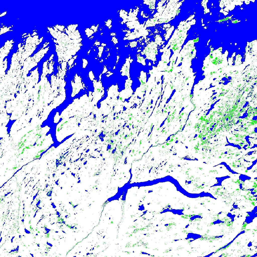
ASTER Global Water Bodies Database V001 NGDA recent views
The ASTER Global Water Bodies Database (ASTWBD) Version 1 data product provides global coverage of water bodies larger than 0.2 square kilometers at a spatial resolution of 1...

Official websites use .gov
A
.gov website belongs to an official government
organization in the United States.
Secure .gov websites use HTTPS
A
lock (
) or https:// means you’ve safely connected to
the .gov website. Share sensitive information only on official,
secure websites.