
-
Global 30-Year Mean Monthly Climatology, 1901-1960 (New et al.) recent views
A data set of 30-year mean monthly surface climate over global land areas, excluding Antarctica. Interpolated from station data to 0.5 degree lat/lon for a range of variables:... -
BOREAS AFM-01 NOAA/ATDD Long-EZ Aircraft Flux Data over the SSA recent views
Data include aircraft altitude, wind direction, wind speed, air temperature, potential temperature, water mixing ratio, U and V components of wind velocity, static pressure,... -
BOREAS Landsat TM Level-3s Imagery: Scaled At-Sensor Radiance in LGSOWG Format recent views
For BOREAS, the level-3s Landsat TM data, along with the other remotely sensed images, were collected in order to provide spatially extensive information over the primary study... -
OMI/Aura Multi-wavelength Aerosol Optical Depth and Single Scattering Albedo Daily L2 Global Gridded 0.25 degree x 0.25 degree V3 (OMAEROG) at GES DISC recent views
This Level-2G daily global gridded product OMAEROG is based on the pixel level OMI Level-2 Aerosol product OMAERO, based on the multi-wavelength algorithm that uses up to 20... -
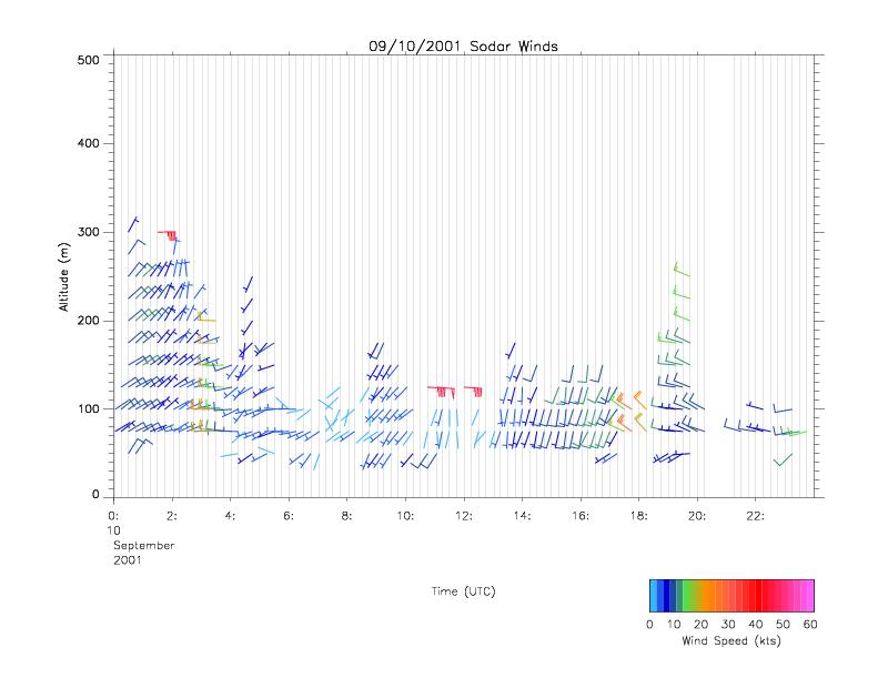
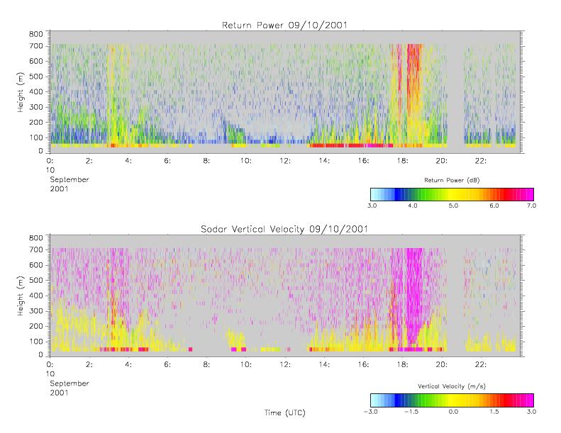
CAMEX-4 MIPS SODAR V1 recent views
The University of Alabama in Huntsville (UAH) Mobile Integrated Profiling System (MIPS) is a mobile atmospheric profiling system. It includes a 915 MHz Doppler profiler, lidar... -
BOREAS RSS-07 Regional LAI and FPAR Images From Ten-Day AVHRR-LAC Composites recent views
The BOREAS RSS-07 team collected various data sets to develop and validate an algorithm to allow the retrieval of the spatial distribution of LAI from remotely sensed images.... -
BOREAS NS001 TMS Level-0 Images in BIL Format recent views
The NS001 TMS imagery, along with the other remotely sensed images, was collected in order to provide spatially extensive information over the primary study areas. This... -
BOREAS TE-01 Soils Data over the SSA Tower Sites in Raster Format recent views
Gridded from vector layers of soil maps that were received from Dr. Darwin Anderson TE-01, who did the original soil mapping in the field during 1994. The vector layers were... -
BOREAS TE-18 Landsat TM Maximum Likelihood Classification Image of the SSA recent views
A Landsat-5 TM image from 06-Aug-1990 was used to derive this classification, the objective of which is to provide BOREAS investigators with a data product that characterizes... -
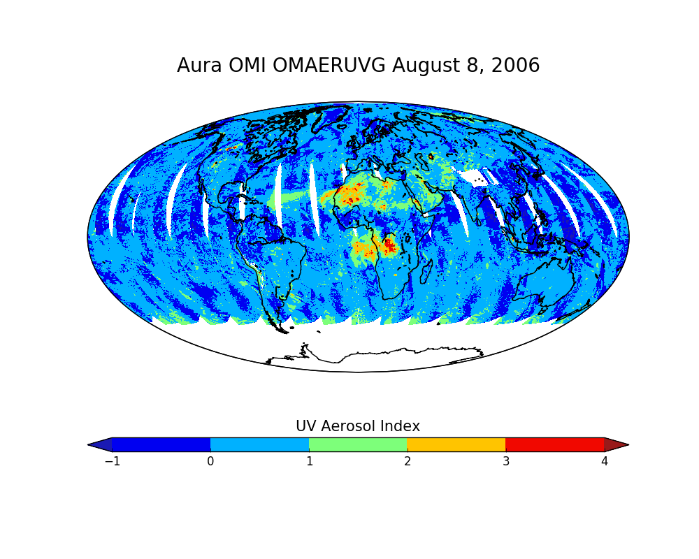
OMI/Aura Near UV Aerosol Optical Depth and Single Scattering Albedo Daily L2 Global Gridded 0.25 degree x 0.25 degree V3 (OMAERUVG) at GES DISC recent views
This Level-2G daily global gridded product OMAERUVG is based on the pixel level OMI Level-2 AERUV product OMAERUV. This Level-2G daily global gridded product OMAERUVG is based... -
BOREAS RSS-02 Extracted Reflectance Factors Derived from ASAS Imagery recent views
Contains calculated bidirectional reflectance factor means derived from extractions of C130-based ASAS measurements made during BOREAS. -
Disk Defect Data recent views
How Data Was Acquired: The data presented is from a physical simulator that simulated engine disks. Sample Rates and Parameter Description: All parameters are sampled once per... -
BOREAS Site and Area Geographic Coordinate Information recent views
Geographic coordinate and other site information from several sources throughout the experiment period. The final set of information is organized into two data sets that provide... -
BOREAS TGB-06 Soil Methane Oxidation and Production from NSA BP and Fen Sites recent views
Contains 1993, 1994, and 1996 methane concentrations from TGB-06 in the NSA and SSA. -
BOREAS HYD-04 Standard Snow Course Data recent views
Contains the standard snow course data collected at various sites in the NSA and SSA by HYD-04. -
DXC'09 Framework recent views
The DXC Framework is a collection of programs and APIs for running and evaluating diagnostic algorithms (DAs). It is complementary to system XML catalogs and datasets. A DXC... -
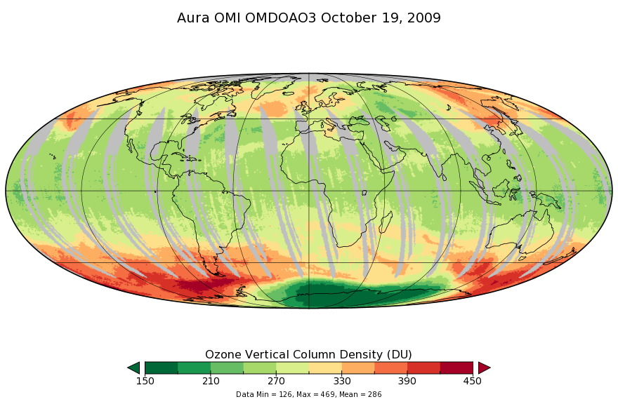
OMI/Aura Ozone (O3) DOAS Total Column Daily L3 1 day 0.25 degree x 0.25 degree V3 (OMDOAO3e) at GES DISC recent views
The OMI science team produces this Level-3 Aura/OMI Global OMDOAO3e Data Products (0.25deg Lat/Lon grids). This Level-3 global total column ozone product is derived from OMDOAO3... -
MISR Level 2 Surface parameters V002 recent views
MIL2ASLS_2 is the Multi-angle Imaging SpectroRadiometer (MISR) Level 2 Land Surface parameters version 2 data product. It contains a variety of information on the Earth's... -
Bowen Ratio Surface Flux: KSU (FIFE) recent views
Assessing the effects of annual burning & topography on surface energy exchanges

Official websites use .gov
A
.gov website belongs to an official government
organization in the United States.
Secure .gov websites use HTTPS
A
lock (
) or https:// means you’ve safely connected to
the .gov website. Share sensitive information only on official,
secure websites.