
-
High Resolution Global Contiguous SIF Estimates from OCO-2 SIF and MODIS, Version 2 NGDA recent views
This dataset provides spatially-contiguous global mean daily solar-induced chlorophyll fluorescence (SIF) estimates at 0.05 degree (approximately 5 km at the equator) spatial... -
MODIS-derived Annual Vegetation Resilience, 2000-2019 NGDA recent views
This dataset provides estimates of vegetation resilience in the Arctic Boreal Vulnerability Experiment (ABoVE) core domain at annual time steps for 2000-2019 and at 300-m... -
Global Fire Emissions Database, Version 4.1 (GFEDv4) NGDA recent views
This dataset provides global estimates of monthly burned area, monthly emissions and fractional contributions of different fire types, daily or 3-hourly fields to scale the... -
ISLSCP II Ecosystem Rooting Depths NGDA recent views
The goal of this study was to predict the global distribution of plant rooting depths based on data about global aboveground vegetation structure and climate. Vertical root... -
MODIS/Terra+Aqua Direct Broadcast Burned Area Monthly L3 Global 500m SIN Grid V061 NGDA recent views
The Terra and Aqua combined MCD64A1 Version 6.1 Burned Area data product is a monthly, global gridded 500 meter (m) product containing per-pixel burned-area and quality... -
High Resolution Land Cover-Specific Solar-Induced Fluorescence, Midwestern USA, 2018 NGDA recent views
This dataset provides estimated solar-induced chlorophyll fluorescence (SIF) of specific vegetation types and total SIF under clear-sky and real/cloudy conditions at a... -
ABoVE: Burn Severity, Fire Progression, Landcover and Field Data, NWT, Canada, 2014 NGDA recent views
This data set provides peatland landcover classification maps, fire progression maps, and vegetation community biophysical data collected from areas that were burned by wildfire... -
Global Monthly Mean Leaf Area Index Climatology, 1981-2015 NGDA recent views
This dataset provides a global 0.25 degree x 0.25 degree gridded monthly mean leaf area index (LAI) climatology as averaged over the period from August 1981 to August 2015. The... -
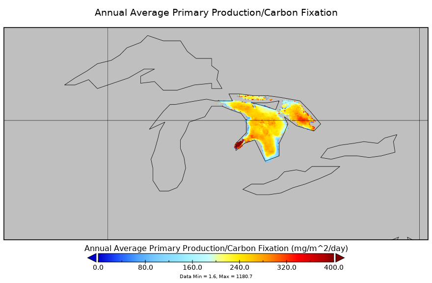
Carbon Monitoring System Lake Huron Primary Production Yearly V1 (CMSLakeHuronPPY) at GES DISC NGDA recent views
Yearly Average primary production/carbon fixation data for Lake Huron. The primary production data is derived using MODIS imagery with model data. The NASA Carbon Monitoring... -
MODIS/Terra Vegetation Indices 16-Day L3 Global 0.05Deg CMG V061 NGDA recent views
The MOD13C1 Version 6.1 product provides a Vegetation Index (VI) value at a per pixel basis. There are two primary vegetation layers. The first is the Normalized Difference... -
MODIS-derived Vegetation and Albedo Parameters for Agroecosystem-Climate Modeling NGDA recent views
This dataset provides MODIS-derived leaf area index (LAI), stem area index (SAI), vegetation area fraction, dominant landcover category, and albedo parameters for the... -
Ecosystem Functional Type Distribution Map for the Conterminous USA, 2001-2014 NGDA recent views
This dataset provides maps of the distribution of ecosystem functional types (EFTs) and the interannual variability of EFTs at 0.05 degree resolution across the conterminous... -
Global MODIS and FLUXNET-derived Daily Gross Primary Production, V2 NGDA recent views
This dataset provides global gridded daily estimates of gross primary production (GPP) and uncertainties at 0.05-degree resolution for the period 2000-03-01 to the recent past.... -
MODIS/Terra Net Evapotranspiration Gap-Filled Yearly L4 Global 500m SIN Grid V061 NGDA recent views
The MOD16A3GF Version 6.1 Evapotranspiration/Latent Heat Flux (ET/LE) product is a year-end gap-filled yearly composite dataset produced at 500 meter (m) pixel resolution. The... -
Terra MODIS Global Binned Inherent Optical Properties (IOP) Data, version R2022.0 NGDA recent views
MODIS (or Moderate-Resolution Imaging Spectroradiometer) is a key instrument aboard the Terra (EOS AM) and Aqua (EOS PM) satellites. Terra's orbit around the Earth is timed so... -
MODIS/Terra Net Evapotranspiration Gap-Filled 8-Day L4 Global 500m SIN Grid V061 NGDA recent views
The MOD16A2GF Version 6.1 Evapotranspiration/Latent Heat Flux (ET/LE) product is a year-end gap-filled 8-day composite dataset produced at 500 meter (m) pixel resolution. The... -
MODIS/Terra Net Primary Production Gap-Filled Yearly L4 Global 500m SIN Grid V061 NGDA recent views
The MOD17A3HGF Version 6.1 product provides information about annual Gross and Net Primary Production (GPP and NPP) at 500 meter (m) pixel resolution. Annual Terra Moderate... -
Aqua MODIS Global Mapped Normalized Difference Vegetation Index Land Reflectance Data, version R2022.0 NGDA recent views
MODIS (or Moderate-Resolution Imaging Spectroradiometer) is a key instrument aboard the Terra (EOS AM) and Aqua (EOS PM) satellites. Terra's orbit around the Earth is timed so... -
MODIS/Aqua Net Evapotranspiration Gap-Filled 8-Day L4 Global 500m SIN Grid V061 NGDA recent views
The MYD16A2GF Version 6.1 Evapotranspiration/Latent Heat Flux (ET/LE) product is a year-end gap-filled 8-day composite dataset produced at 500 meter (m) pixel resolution. The... -
MODIS/Aqua Thermal Anomalies/Fire 8-Day L3 Global 1km SIN Grid V061 NGDA recent views
The Aqua Moderate Resolution Imaging Spectroradiometer (MODIS) Thermal Anomalies and Fire 8-Day (MYD14A2) Version 6.1 data are generated at 1 kilometer (km) spatial resolution...

Official websites use .gov
A
.gov website belongs to an official government
organization in the United States.
Secure .gov websites use HTTPS
A
lock (
) or https:// means you’ve safely connected to
the .gov website. Share sensitive information only on official,
secure websites.