High Resolution Land Cover-Specific Solar-Induced Fluorescence, Midwestern USA, 2018
Access & Use Information
Downloads & Resources
-
Google Scholar search resultsHTML
Search results for publications that cite this dataset by its DOI.
-
Download this datasetHTML
This link allows direct data access via Earthdata login
-
View documentation related to this datasetHTML
ORNL DAAC Data Set Documentation
-
This dataset's landing pageHTML
Data set Landing Page DOI URL
-
Use OPeNDAP to access the dataset's dataHTML
USE SERVICE API
-
View documentation related to this datasetPDF
High Resolution Land Cover-Specific Solar-Induced Fluorescence, Midwestern...
-
Get a related visualizationPNG
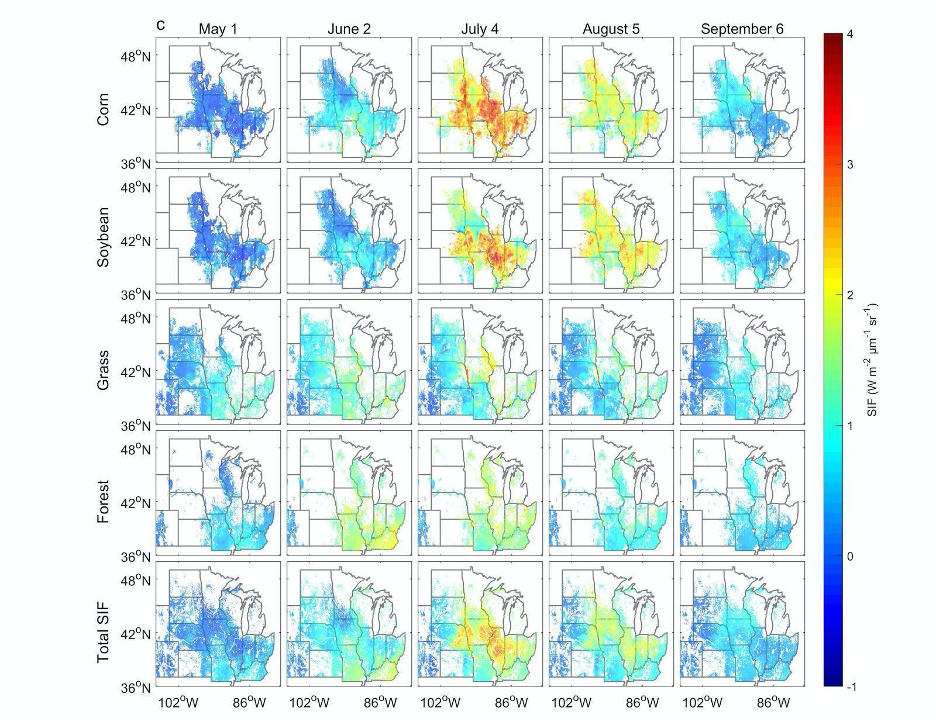
Examples of spatial patterns of reconstructed SIF at 4 km resolution. Only...
-
View documentation related to this datasetHTML
The THREDDS location for this Collection.
-
Landing PageLanding Page
Dates
| Metadata Created Date | December 1, 2022 |
|---|---|
| Metadata Updated Date | December 6, 2023 |
Metadata Source
- Data.json Data.json Metadata
Harvested from NASA Data.json
Other Data Resources
- Geoplatform Metadata Information
Graphic Preview

Additional Metadata
| Resource Type | Dataset |
|---|---|
| Metadata Created Date | December 1, 2022 |
| Metadata Updated Date | December 6, 2023 |
| Publisher | ORNL_DAAC |
| Maintainer | |
| Identifier | C2345900038-ORNL_CLOUD |
| Data First Published | 2021-03-15 |
| Language | en-US |
| Data Last Modified | 2023-07-17 |
| Category | CMS, geospatial |
| Public Access Level | public |
| Bureau Code | 026:00 |
| Metadata Context | https://project-open-data.cio.gov/v1.1/schema/catalog.jsonld |
| Metadata Catalog ID | https://data.nasa.gov/data.json |
| Schema Version | https://project-open-data.cio.gov/v1.1/schema |
| Catalog Describedby | https://project-open-data.cio.gov/v1.1/schema/catalog.json |
| Citation | Wang, C., K. Guan, B. Peng, C. Jiang, J. Peng, G. Wu, C. Frankenberg, P. Koehler, X. Yang, Y. Cai, and Y. Huang. 2021. High Resolution Land Cover-Specific Solar-Induced Fluorescence, Midwestern USA, 2018. ORNL DAAC, Oak Ridge, Tennessee, USA. https://doi.org/10.3334/ORNLDAAC/1813 |
| Graphic Preview Description | Examples of spatial patterns of reconstructed SIF at 4 km resolution. Only pixels with a fraction of the specific vegetation type larger than 0.1 are shown. For Total SIF, only pixels with a fraction of corn, soybean, grass/pasture, and forest larger than 0.8 are displayed. Source: Wang et al., 2020. |
| Graphic Preview File | https://daac.ornl.gov/CMS/guides/SIF_PAR_fPAR_US_Midwest_2018_Fig1.png |
| Harvest Object Id | 882c66ef-b2cc-4d72-8bb5-b3143f505862 |
| Harvest Source Id | 58f92550-7a01-4f00-b1b2-8dc953bd598f |
| Harvest Source Title | NASA Data.json |
| Homepage URL | https://doi.org/10.3334/ORNLDAAC/1813 |
| Metadata Type | geospatial |
| Old Spatial | -110.02 34.98 -77.98 49.94 |
| Program Code | 026:001 |
| Source Datajson Identifier | True |
| Source Hash | f997901afb85d25a3c164f56f82d0b3f48701dc0a4416e9e5a86e8f117ad3be7 |
| Source Schema Version | 1.1 |
| Spatial | |
| Temporal | 2018-05-02T00:00:00Z/2018-09-23T23:59:59Z |
Didn't find what you're looking for? Suggest a dataset here.


