
-
ISLSCP II Global Sea Ice Concentration recent views
This International Satellite Land Surface Climatology Project (ISLSCP) Initiative II data set, ISLSCP II Global Sea Ice Concentration, is based on the Goddard Space Flight... -
Primary Ancillary Data Geo-Colocated to OMI/Aura VIS 1-Orbit L2 Swath 13x24km V4 (OMVANC) at GES DISC recent views
The Primary Ancillary Data Geo-Colocated to OMI/Aura VIS 1-Orbit L2 Swath 13x24km (OMVANC) provides selected parameters from GEOS-5 Forward Processing for Instrument Teams (FP-... -
MERRA-2 tavgU_2d_glc_Nx: 2d,diurnal,Time-Averaged,Single-Level,Assimilation,Land Ice Surface Diagnostics 0.625 x 0.5 degree V5.12.4 (M2TUNXGLC) at GES DISC recent views
M2TUNXGLC (or tavgU_2d_glc_Nx) is a 2-dimensional monthly diurnal means data collection in Modern-Era Retrospective analysis for Research and Applications version 2 (MERRA-2).... -
MERRA-2 tavgM_2d_int_Nx: 2d,Monthly mean,Time-Averaged,Single-Level,Assimilation,Vertically Integrated Diagnostics 0.625 x 0.5 degree V5.12.4 (M2TMNXINT) at GES DISC recent views
M2TMNXINT (or tavgM_2d_int_Nx) is a time-averaged 2-dimensional monthly mean data collection in Modern-Era Retrospective analysis for Research and Applications version 2... -
Alaska's Changing YK Delta: Knowledge Exchange between Elders and Geoscientists, 2018 recent views
This dataset provides a booklet documenting the discussions and outcomes from a knowledge-exchange meeting with Yup'ik elders from the Yukon-Kuskokwim Delta (YKD), western... -
ABoVE: Annual Thaw Slump Expansion on East Fork Chandalar River, Alaska, 2008-2017 recent views
This dataset provides a time series of spatial data showing the expansion of a thaw slump on the East Fork Chandalar River near the community of Venetie, Alaska, from 2008... -
ABoVE: Rain-on-Snow Frequency and Distribution during Cold Seasons, Alaska, 2003-2016 NGDA recent views
This dataset provides maps of rain-on-snow (ROS) events across Alaska for the individual months of November to March 2002-2011 and November to March 2012-2016, and annual water... -
ABoVE: Last Day of Spring Snow, Alaska, USA, and Yukon Territory, Canada, 2000-2016 NGDA recent views
This dataset provides the last day of spring snow cover for most of Alaska and the Yukon Territory for 2000 through 2016. The data are based on the MODIS daily snow cover... -
ABoVE: Passive Microwave-derived Annual Snowoff Date Maps, 1988-2018 recent views
This dataset provides annual maps of the snowoff (SO) date from 1988-2018 across Alaska and parts of Far East Russia and northwest Canada at a resolution of 6.25 km. SO date is... -
NCA-LDAS Noah-3.3 Land Surface Model L4 Daily 0.125 x 0.125 degree V2.0 (NCALDAS_NOAH0125_D) at GES DISC recent views
The National Climate Assessment - Land Data Assimilation System, or NCA-LDAS, is a terrestrial water reanalysis in support of the United States Global Change Research Program's... -
OPERA Radiometric Terrain Corrected SAR Backscatter from Sentinel-1 Static Layers validated product (Version 1) recent views
The Observational Products for End-Users from Remote Sensing Analysis (OPERA) Radiometric Terrain Corrected (RTC) SAR Backscatter from Sentinel-1 (S1) Static Layers... -
BOREAS HYD-03 Subcanopy Meteorological Data recent views
This table contains the sub-canopy meteorological data collected by HYD-3. -
ISLSCP II ECMWF Near-Surface Meteorology Parameters recent views
This data set for the ISLSCP Initiative II data collection provides meteorology data with fixed, monthly, monthly-6-hourly, 6-hourly, and 3-hourly temporal resolutions. The data... -
A Concise Experiment Plan for the Arctic-Boreal Vulnerability Experiment recent views
This document presents the Concise Experiment Plan for NASA's Arctic-Boreal Vulnerability Experiment (ABoVE) to serve as a guide to the Program as it identifies the research to... -
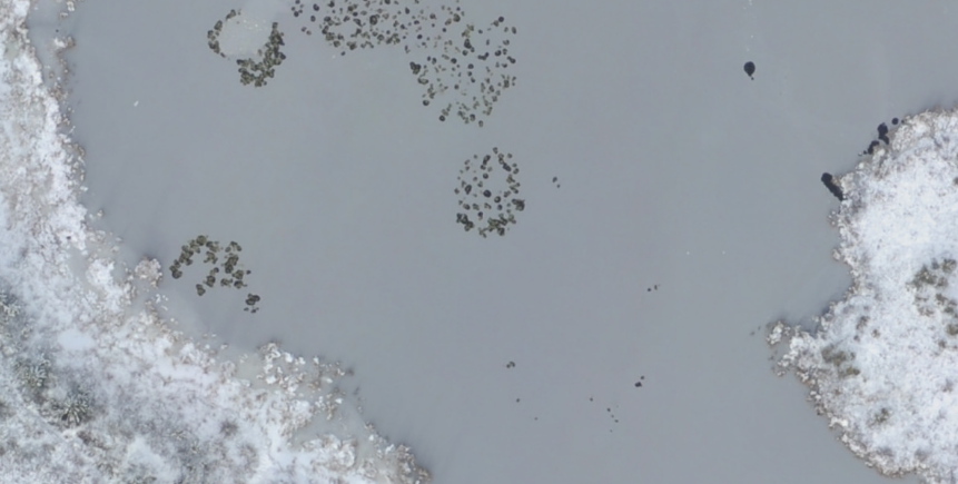
ABoVE: Aerial Photographs of Frozen Lakes near Fairbanks, Alaska, October 2014 recent views
This dataset includes high resolution orthophotographs of 21 lakes in the region of Fairbanks, Alaska, USA. Aerial photographs were taken on October 8, 2014, three days after... -
Pre-ABoVE: Remotely Sensed Active Layer Thickness, Barrow, Alaska, 2006-2011 recent views
Active layer thickness (ALT) is a critical parameter for monitoring the status of permafrost that is typically measured at specific locations using probing, in situ temperature... -
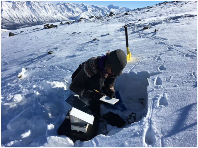
ABoVE: Dall Sheep Track Sinking Depths, Snow Depth, Hardness, and Density, 2017 recent views
This dataset contains Dall sheep (Ovis dalli dalli) hoof sinking depths in snow tracks, and snow depth, hardness, and density measurements in snow pits adjacent to the tracks.... -
Pre-ABoVE: Remotely Sensed Active Layer Thickness, Prudhoe Bay, Alaska, 1992-2000 recent views
Active layer thickness (ALT) is a critical parameter for monitoring the status of permafrost that is typically measured at specific locations using probing, in situ temperature... -
Pre-ABoVE: Ground-penetrating Radar Measurements of ALT on the Alaska North Slope recent views
This data set includes estimates of permafrost Active Layer Thickness (ALT; cm), and calculated uncertainties, derived using a ground-penetrating radar (GPR) system in the field...

Official websites use .gov
A
.gov website belongs to an official government
organization in the United States.
Secure .gov websites use HTTPS
A
lock (
) or https:// means you’ve safely connected to
the .gov website. Share sensitive information only on official,
secure websites.