
-
World Glacier Inventory, Version 1 recent views
The World Glacier Inventory (WGI) contains information for over 130,000 glaciers, or about 85% of the total estimated number of glaciers. Inventory parameters include geographic... -
Snow Melt Onset Over Arctic Sea Ice from SMMR and SSM/I-SSMIS Brightness Temperatures, Version 5 recent views
This data set includes yearly snow melt onset dates over Arctic sea ice derived from Scanning Multichannel Microwave Radiometer (SMMR), Special Sensor Microwave/Imager (SSM/I),... -
Weather Research and Forecasting (WRF) North American Mountain Snow Data, Version 1 recent views
This data set consists of modeled snow water equivalent (SWE) data for 10 mountain ranges in North America, simulated by the Weather Research and Forecasting (WRF) regional... -
Daily Great Lakes Ice Concentration, 1973 Onward, Version 1 NGDA recent views
This data set consists of daily gridded lake ice concentration for the Laurentian Great Lakes from the NOAA Great Lakes Environmental Research Laboratory (GLERL). The data are... -
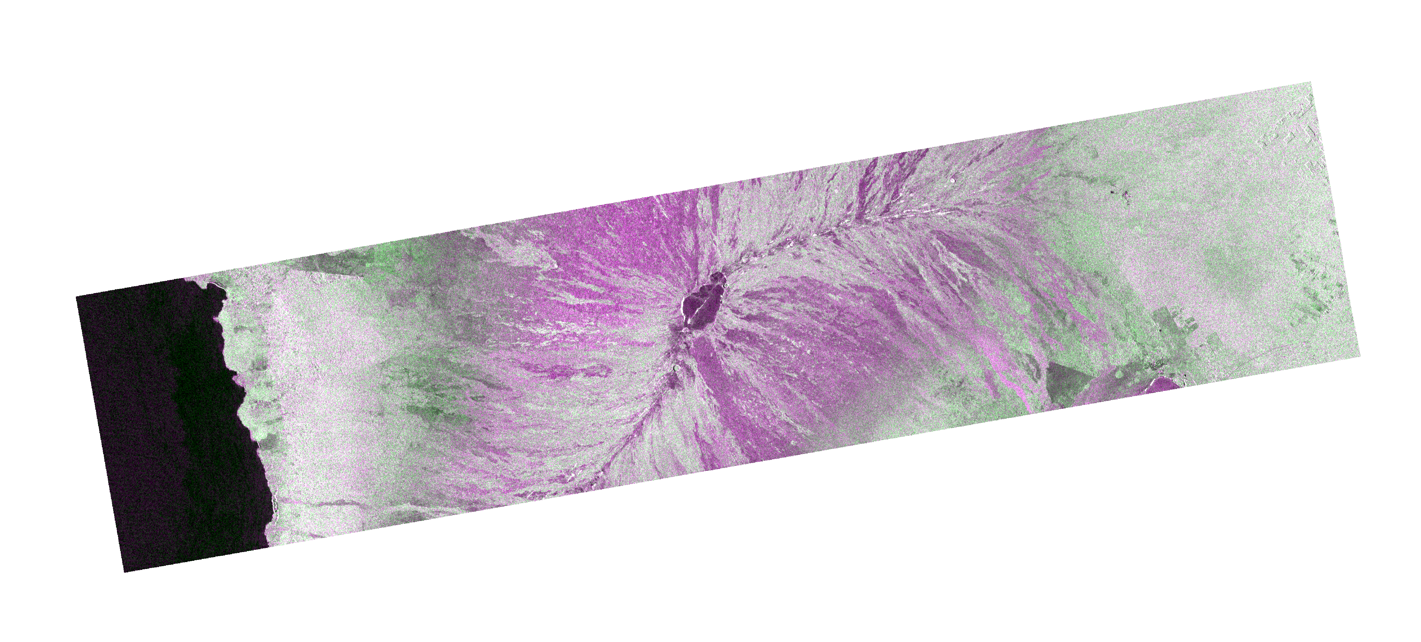
OPERA Radiometric Terrain Corrected SAR Backscatter from Sentinel-1 validated product (Version 1) recent views
The Observational Products for End-Users from Remote Sensing Analysis (OPERA) Radiometric Terrain Corrected (RTC) SAR Backscatter from Sentinel-1 (S1) validated product consists... -
Soil Temperature Station Data from Permafrost Regions of Russia (Selection of Five Stations), 1915 - 2000, Version 1 recent views
This data set includes soil temperature data from boreholes located at five stations in Russia: Yakutsk, Verkhoyansk, Pokrovsk, Isit', and Churapcha. The data have been compiled... -
USGS Digital Orthophoto Quadrangles recent views
A Digital Orthophoto Quadrangle (DOQ) is a computer-generated image of an aerial photograph in which the image displacement caused by terrain relief and camera tilt has been... -
Sea Ice Index, Version 3 recent views
The Sea Ice Index provides a quick look at Arctic- and Antarctic-wide changes in sea ice. It is a source for consistent, up-to-date sea ice extent and concentration images, in... -
Arctic EASE-Grid Freeze and Thaw Depths, 1901 - 2002, Version 1 recent views
This data set contains mean, median, minimum and maximum freeze and thaw depths for each year from 1901 to 2002 on the 25 km resolution Equal-Area Scalable Earth Grid (EASE-... -
CLPX-Ground: ISA Snow Pit Measurements, Version 2 recent views
This data set consists of snow pit data from nine study areas, within three larger-scale areas in northern Colorado (Fraser, North Park, and Rabbit Ears Meso-cell Study Areas... -
GEWEX SRB Integrated Product (Rel-4) Ancillary 3-Hourly recent views
GEWEX SRB Integrated Product (Rel-4) Ancillary 3-Hourly contains the global fields of meteorology, clouds and other ancillary data that serves as the inputs to the GEWEX SRB... -
Rock glaciers, Upper Engadin, Switzerland, Version 1 recent views
The investigated region is called Upper Engadin and is situated in the Eastern part of the Swiss Alps. The area is characterized by a high situated valley floor with an average... -
Sea Ice in the Belcher Islands, Nunavut, Canada, Version 1 recent views
This data set contains interviews of three hunters from Sanikiliaq, Belcher Islands, in the territory of Nunavut, Canada. The hunters describe their observations of sea ice... -
ATLAS/ICESat-2 ATL03 Ancillary Masks, Version 1 recent views
This ancillary ICESat-2 data set contains four static surface masks (land ice, sea ice, land, and ocean) provided by ATL03 to reduce the volume of data that each surface-... -
Permafrost Map of Alaska, USA, Version 1 recent views
This data set consists of a geo-referenced digital map and attribute data derived from the publication 'Permafrost map of Alaska'. The map is presented at a scale of 1 to...

Official websites use .gov
A
.gov website belongs to an official government
organization in the United States.
Secure .gov websites use HTTPS
A
lock (
) or https:// means you’ve safely connected to
the .gov website. Share sensitive information only on official,
secure websites.