Forest Aboveground Biomass for the Southwestern U.S. from MISR, 2000-2021
Access & Use Information
Downloads & Resources
-
Google Scholar search resultsHTML
Search results for publications that cite this dataset by its DOI.
-
Download this datasetHTML
This link allows direct data access via Earthdata login
-
View documentation related to this datasetHTML
ORNL DAAC Data Set Documentation
-
This dataset's landing pageHTML
Data set Landing Page DOI URL
-
View documentation related to this datasetPDF
Forest Aboveground Biomass for the Southwestern U.S. from MISR, 2000-2021:...
-
Get a related visualizationPNG
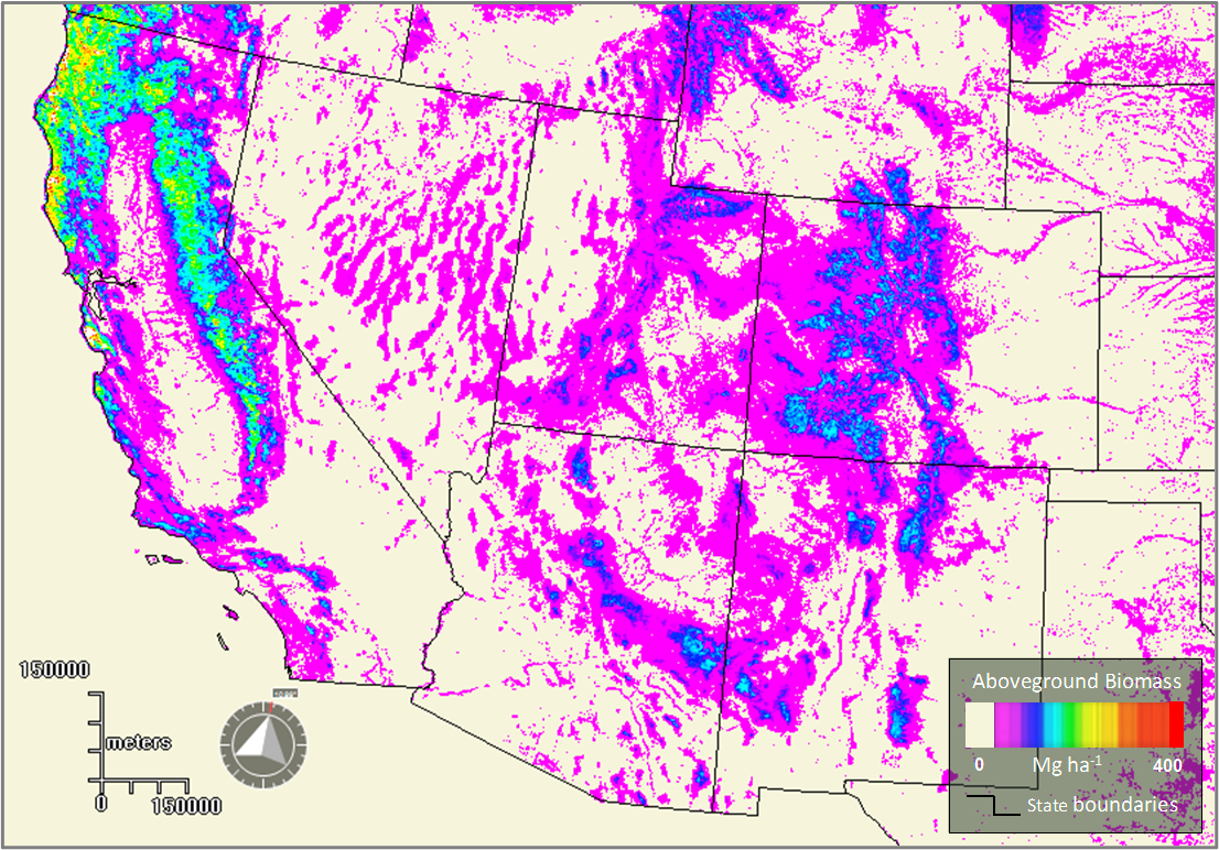
Generalized 2005 aboveground biomass (AGB) map for the southwestern U.S,...
-
Landing PageLanding Page
Dates
| Metadata Created Date | May 30, 2023 |
|---|---|
| Metadata Updated Date | December 6, 2023 |
Metadata Source
- Data.json Data.json Metadata
Harvested from NASA Data.json
Other Data Resources
- Geoplatform Metadata Information
Graphic Preview

Additional Metadata
| Resource Type | Dataset |
|---|---|
| Metadata Created Date | May 30, 2023 |
| Metadata Updated Date | December 6, 2023 |
| Publisher | ORNL_DAAC |
| Maintainer | |
| Identifier | C2515861985-ORNL_CLOUD |
| Data First Published | 2022-03-21 |
| Language | en-US |
| Data Last Modified | 2023-06-12 |
| Category | NACP, geospatial |
| Public Access Level | public |
| Bureau Code | 026:00 |
| Metadata Context | https://project-open-data.cio.gov/v1.1/schema/catalog.jsonld |
| Metadata Catalog ID | https://data.nasa.gov/data.json |
| Schema Version | https://project-open-data.cio.gov/v1.1/schema |
| Catalog Describedby | https://project-open-data.cio.gov/v1.1/schema/catalog.json |
| Citation | Chopping, M.J., Z. Wang, C. Schaaf, M.A. Bull, and R.R. Duchesne. 2022. Forest Aboveground Biomass for the Southwestern U.S. from MISR, 2000-2021. ORNL DAAC, Oak Ridge, Tennessee, USA. https://doi.org/10.3334/ORNLDAAC/1978 |
| Graphic Preview Description | Generalized 2005 aboveground biomass (AGB) map for the southwestern U.S, derived from the Multiangle Imaging Spectro-Radiometer (MISR). |
| Graphic Preview File | https://daac.ornl.gov/NACP/guides/MISR_Forest_AGB_SW_US_Fig1.png |
| Harvest Object Id | 9911a741-799c-4de2-9d2c-02f423b952e2 |
| Harvest Source Id | 58f92550-7a01-4f00-b1b2-8dc953bd598f |
| Harvest Source Title | NASA Data.json |
| Homepage URL | https://doi.org/10.3334/ORNLDAAC/1978 |
| Metadata Type | geospatial |
| Old Spatial | -126.18 28.6 -99.02 46.28 |
| Program Code | 026:001 |
| Source Datajson Identifier | True |
| Source Hash | 839bad943a164bbd8be13914ea4d7f55d83f694a0b2f685c5b1c68ae69b60876 |
| Source Schema Version | 1.1 |
| Spatial | |
| Temporal | 2000-05-15T00:00:00Z/2021-06-30T23:59:59Z |
Didn't find what you're looking for? Suggest a dataset here.


