
-
Federal
Process-structure-properties investigations for laser powder bed fused IN718 in the as-built condition recent views
National Institute of Standards and Technology —
This data repository provides a central location for a body of work using one build of nickel-based alloy 718 (IN718) material and resulted in three different... -
Federal
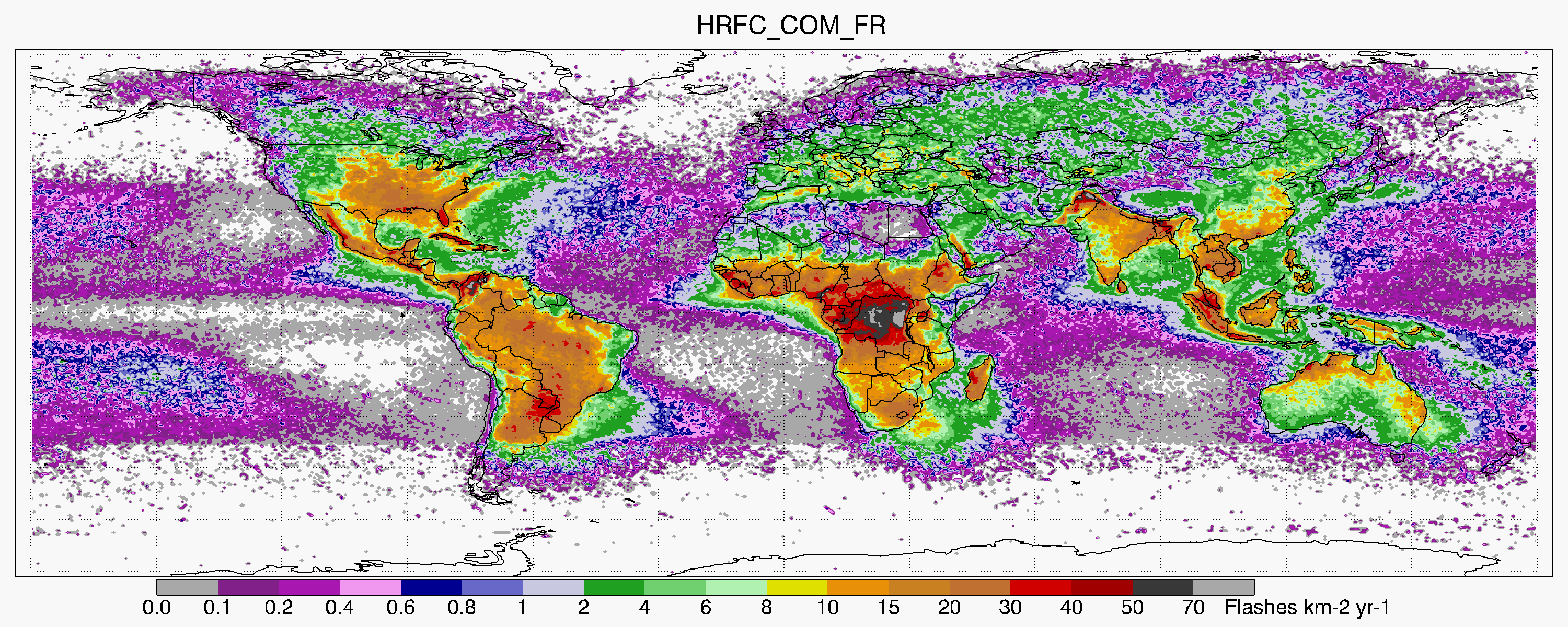
LIS/OTD 0.5 Degree High Resolution Full Climatology (HRFC) V2.3.2015 recent views
National Aeronautics and Space Administration —
The LIS/OTD 0.5 Degree High Resolution Full Climatology (HRFC) contains a variety of gridded climatologies of total lightning flash rates obtained from two lightning... -
Federal
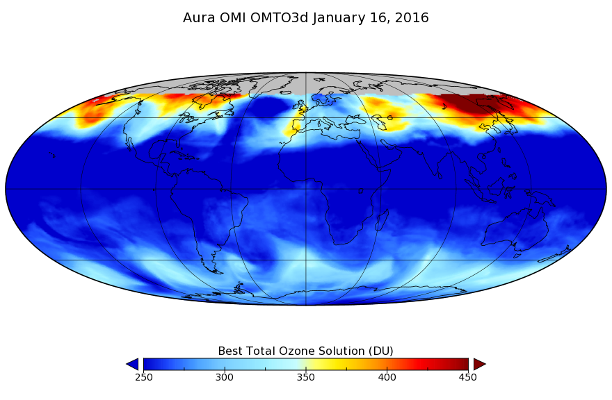
OMI/Aura TOMS-Like Ozone, Aerosol Index, Cloud Radiance Fraction L3 1 day 1 degree x 1 degree V3 (OMTO3d) at GES DISC recent views
National Aeronautics and Space Administration —
The OMI science team produces this Level-3 daily global TOMS-Like Total Column Ozone gridded product OMTO3d (1 deg Lat/Lon grids). The OMTO3d product is produced by... -
Federal
BOREAS AFM-06 Boundary Layer Height Data recent views
National Aeronautics and Space Administration —
Contains AFM-06 hourly inversion height measurements. -
Federal
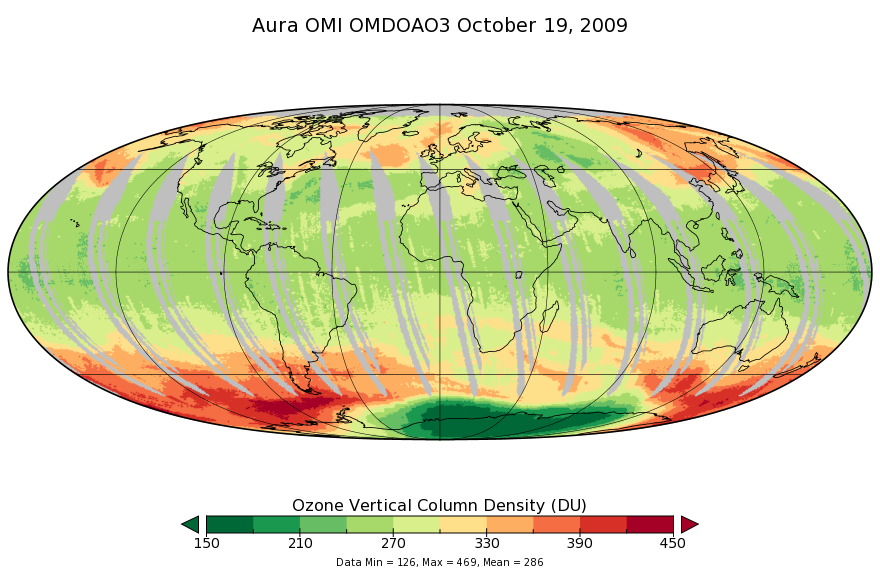
OMI/Aura Ozone (O3) DOAS Total Column Daily L3 1 day 0.25 degree x 0.25 degree V3 (OMDOAO3e) at GES DISC recent views
National Aeronautics and Space Administration —
The OMI science team produces this Level-3 Aura/OMI Global OMDOAO3e Data Products (0.25deg Lat/Lon grids). This Level-3 global total column ozone product is derived... -
Federal
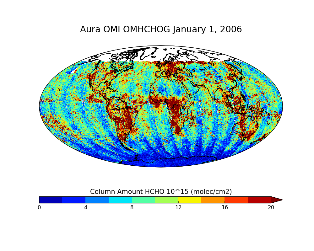
OMI/Aura Formaldehyde (HCHO) Total Column Daily L2 Global Gridded 0.25 degree x 0.25 degree V3 (OMHCHOG) at GES DISC recent views
National Aeronautics and Space Administration —
This Level-2G daily global gridded product OMHCHOG is based on the pixel level OMI Level-2 HCHO product OMHCHO. OMHCHOG data product is a special Level-2 Global... -
Federal
BOREAS RSS-02 Extracted Reflectance Factors Derived from ASAS Imagery recent views
National Aeronautics and Space Administration —
Contains calculated bidirectional reflectance factor means derived from extractions of C130-based ASAS measurements made during BOREAS. -
Federal
BOREAS TE-18 Landsat TM Maximum Likelihood Classification Image of the SSA recent views
National Aeronautics and Space Administration —
A Landsat-5 TM image from 06-Aug-1990 was used to derive this classification, the objective of which is to provide BOREAS investigators with a data product that... -
Federal
BOREAS HYD-04 Standard Snow Course Data recent views
National Aeronautics and Space Administration —
Contains the standard snow course data collected at various sites in the NSA and SSA by HYD-04. -
Federal
BOREAS TGB-06 Soil Methane Oxidation and Production from NSA BP and Fen Sites recent views
National Aeronautics and Space Administration —
Contains 1993, 1994, and 1996 methane concentrations from TGB-06 in the NSA and SSA. -
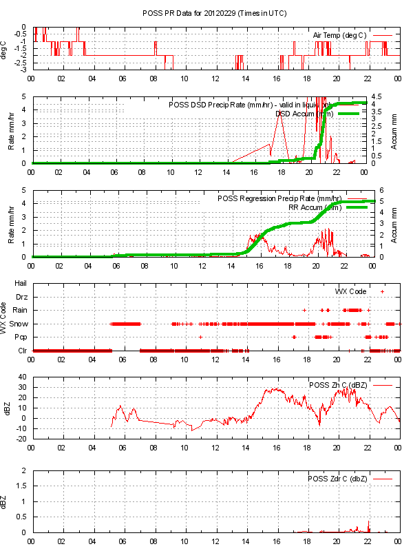
Federal
GPM GROUND VALIDATION ENVIRONMENT CANADA (EC) PRECIPITATION OCCURRENCE SENSOR SYSTEM (POSS) GCPEX V1 recent views
National Aeronautics and Space Administration —
The GPM Ground Validation Environment Canada (EC) Precipitation Occurrence Sensor System (POSS) GCPEx dataset is comprised of data gathered during the GPM Cold-season... -
Federal
BOREAS TE-01 Soils Data over the SSA Tower Sites in Raster Format recent views
National Aeronautics and Space Administration —
Gridded from vector layers of soil maps that were received from Dr. Darwin Anderson TE-01, who did the original soil mapping in the field during 1994. The vector... -
Federal
BOREAS RSS-07 Regional LAI and FPAR Images From Ten-Day AVHRR-LAC Composites recent views
National Aeronautics and Space Administration —
The BOREAS RSS-07 team collected various data sets to develop and validate an algorithm to allow the retrieval of the spatial distribution of LAI from remotely sensed... -
Federal
BOREAS NS001 TMS Level-0 Images in BIL Format recent views
National Aeronautics and Space Administration —
The NS001 TMS imagery, along with the other remotely sensed images, was collected in order to provide spatially extensive information over the primary study areas.... -
Federal
BOREAS AFM-01 NOAA/ATDD Long-EZ Aircraft Flux Data over the SSA recent views
National Aeronautics and Space Administration —
Data include aircraft altitude, wind direction, wind speed, air temperature, potential temperature, water mixing ratio, U and V components of wind velocity, static... -
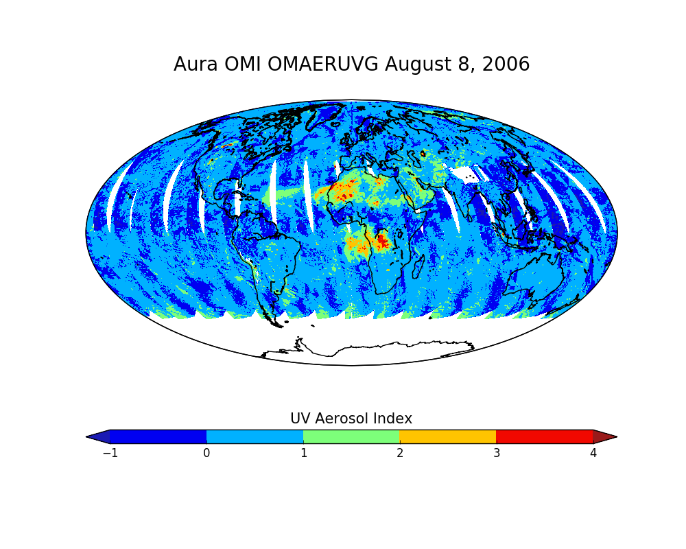
Federal
OMI/Aura Near UV Aerosol Optical Depth and Single Scattering Albedo Daily L2 Global Gridded 0.25 degree x 0.25 degree V3 (OMAERUVG) at GES DISC recent views
National Aeronautics and Space Administration —
This Level-2G daily global gridded product OMAERUVG is based on the pixel level OMI Level-2 AERUV product OMAERUV. This Level-2G daily global gridded product OMAERUVG... -
Federal
OMI/Aura Multi-wavelength Aerosol Optical Depth and Single Scattering Albedo Daily L2 Global Gridded 0.25 degree x 0.25 degree V3 (OMAEROG) at GES DISC recent views
National Aeronautics and Space Administration —
This Level-2G daily global gridded product OMAEROG is based on the pixel level OMI Level-2 Aerosol product OMAERO, based on the multi-wavelength algorithm that uses... -
Federal
Soil Thermal Conductivity Data (FIFE) recent views
National Aeronautics and Space Administration —
1989 FIFE staff science soil properties measurements -
Federal
Bowen Ratio Surface Flux: Smith (FIFE) recent views
National Aeronautics and Space Administration —
Retrieval of surface fluxes from a combination of satellite & surface platforms -
Federal
BOREAS TGB-07 Rainwater Herbicide and Organochlorine Concentration Data recent views
National Aeronautics and Space Administration —
Contains 1993 and 1994 herbicide concentrations in rain samples for TGB-07 in the SSA.

Official websites use .gov
A
.gov website belongs to an official government
organization in the United States.
Secure .gov websites use HTTPS
A
lock (
) or https:// means you’ve safely connected to
the .gov website. Share sensitive information only on official,
secure websites.