
-
Federal
WorldView-3 Level 2A Multispectral 8-Band Satellite Imagery
National Aeronautics and Space Administration —
The WorldView-3 Level 2A Multispectral 8-Band Imagery collection contains satellite imagery acquired from Maxar Technologies (formerly known as DigitalGlobe) by the... -
Federal
NACP North American Forest Dynamics Project: Forest Disturbance and Regrowth Data
National Aeronautics and Space Administration —
This data set provides the results of time-series analyses of Landsat imagery for 55 selected forested sites across the conterminous U.S.A. The output is a pair of... -
Federal
EMAG2v3: Earth Magnetic Anomaly Grid (2-arc-minute resolution)
National Oceanic and Atmospheric Administration, Department of Commerce —
EMAG2v3 is a global Earth Magnetic Anomaly Grid compiled from satellite, ship, and airborne magnetic measurements. It is a significant update of the previous release... -
County
Housing Market Value Analysis - Allegheny County Economic Development
Allegheny County / City of Pittsburgh / Western PA Regional Data Center —
In 2017, the County Department of Economic Development, in conjunction with Reinvestment Fund, completed the 2016 Market Value Analysis (MVA) for Allegheny County. A... -
Federal
GPM IMERG Final Precipitation L3 1 day 0.1 degree x 0.1 degree V07 (GPM_3IMERGDF) at GES DISC
National Aeronautics and Space Administration —
Version 07 is the current version of the data set. Older versions will no longer be available and have been superseded by Version 07. The Integrated Multi-satellitE... -
Federal
Radio Frequency Interference Measurements of Industrial Machinery
National Institute of Standards and Technology —
The 2.4 GHz ISM band is shared by Wi-Fi, Bluetooth, Wireless HART, ISA100.11a, and several other industrial wireless systems. Our dataset contains comprehensive... -
Federal
TSIS TIM Level 3 Total Solar Irradiance 24-Hour Means V04 (TSIS_TSI_L3_24HR) at GES DISC
National Aeronautics and Space Administration —
Version 04 is the current release of this data product, and supercedes all previous versions. The TSIS TIM Level 3 Total Solar Irradiance (TSI) 24-Hour Means data... -
Federal
Process-structure-properties investigations for laser powder bed fused IN718 in the as-built condition
National Institute of Standards and Technology —
This data repository provides a central location for a body of work using one build of nickel-based alloy 718 (IN718) material and resulted in three different... -
Federal
Data for Filtering Organized 3D Point Clouds for Bin Picking Applications
National Institute of Standards and Technology —
Contains scans of a bin filled with different parts ( screws, nuts, rods, spheres, sprockets). For each part type, RGB image and organized 3D point cloud obtained... -
Federal
United States Geothermal Supply Curves 2024
Department of Energy —
This data packet contains supply curves and a composite siting exclusion TIFF for EGS and hydrothermal geothermal across the contiguous United States. The supply... -
Federal
Hardware-in-the-loop Laboratory Performance Verification of Flexible Building Equipment in a Typical Commercial Building: Performance of Heating, Ventilation, and Air Conditioning and Thermal Energy Storage Across the United States
National Institute of Standards and Technology —
This high-fidelity dataset measures the holistic load flexibility performance of a suite of commonly used commercial building heating, ventilating, and air-... -
Federal
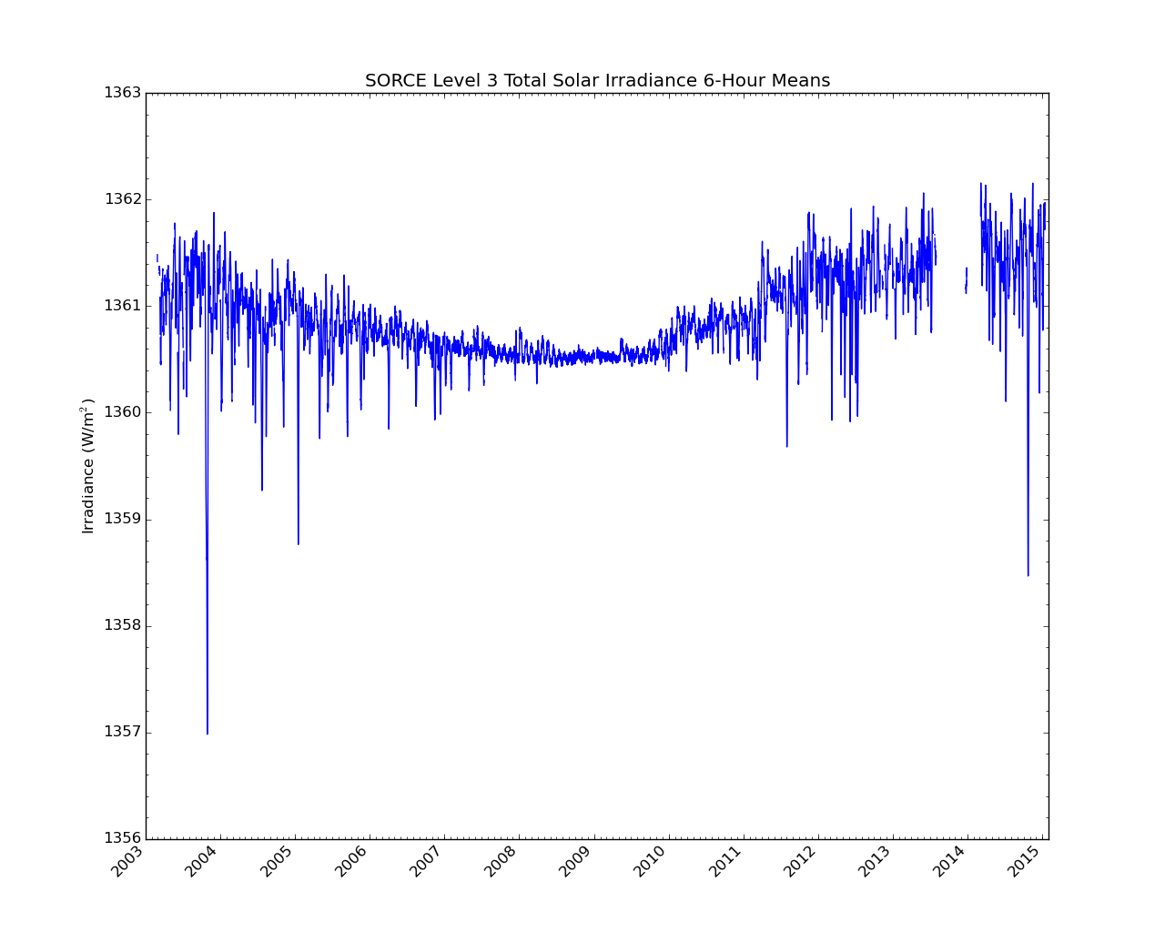
SORCE Level 3 Total Solar Irradiance 6-Hour Means V019 (SOR3TSI6) at GES DISC
National Aeronautics and Space Administration —
SOR3TSI6 Version 019 is the final version of this data product, and supersedes all previous versions. The Total Solar Irradiance (TSI) data set SOR3TSI6 contains the... -
Federal
Global Hydrologic Soil Groups (HYSOGs250m) for Curve Number-Based Runoff Modeling
National Aeronautics and Space Administration —
This dataset - HYSOGs250m - represents a globally consistent, gridded dataset of hydrologic soil groups (HSGs) with a geographical resolution of 1/480 decimal... -
Federal
Project HOTSPOT: Mountain Home Well Borehole Geophysics Database
Department of Energy —
The Snake River Plain (SRP), Idaho, hosts potential geothermal resources due to elevated groundwater temperatures associated with the thermal anomaly Yellowstone-... -
Federal
A Compilation of Global Soil Microbial Biomass Carbon, Nitrogen, and Phosphorus Data
National Aeronautics and Space Administration —
This data set provides the concentrations of soil microbial biomass carbon (C), nitrogen (N) and phosphorus (P), soil organic carbon, total nitrogen, and total... -
Federal
Global 1-km Gridded Thickness of Soil, Regolith, and Sedimentary Deposit Layers
National Aeronautics and Space Administration —
This data set provides high-resolution estimates of the thickness of the permeable layers above bedrock (soil, regolith, and sedimentary deposits) within a global... -
Federal
Daymet: Daily Surface Weather Data on a 1-km Grid for North America, Version 4 R1
National Aeronautics and Space Administration —
This dataset provides Daymet Version 4 R1 data as gridded estimates of daily weather parameters for North America, Hawaii, and Puerto Rico. Daymet variables include... -
Federal
Global Fire Emissions Database, Version 4.1 (GFEDv4)
National Aeronautics and Space Administration —
This dataset provides global estimates of monthly burned area, monthly emissions and fractional contributions of different fire types, daily or 3-hourly fields to... -
Federal
Global Maps of Atmospheric Nitrogen Deposition, 1860, 1993, and 2050
National Aeronautics and Space Administration —
This data set provides global gridded estimates of atmospheric deposition of total inorganic nitrogen (N), NHx (NH3 and NH4+), and NOy (all oxidized forms of nitrogen...

Official websites use .gov
A
.gov website belongs to an official government
organization in the United States.
Secure .gov websites use HTTPS
A
lock (
) or https:// means you’ve safely connected to
the .gov website. Share sensitive information only on official,
secure websites.