
-
Federal
NOAA NEXt-Generation RADar (NEXRAD) Products NGDA 94 recent views
National Oceanic and Atmospheric Administration, Department of Commerce —
This dataset consists of Level III weather radar products collected from Next-Generation Radar (NEXRAD) stations located in the contiguous United States, Alaska,... -
Federal
Defense Meteorological Satellite Program (DMSP) 20 recent views
National Oceanic and Atmospheric Administration, Department of Commerce —
The Defense Meteorological Satellite Program (DMSP) satellites collect visible and infrared cloud imagery as well as monitoring the atmospheric, oceanographic,... -
Federal
NOAA Next Generation Radar (NEXRAD) Level 3 Products 17 recent views
National Oceanic and Atmospheric Administration, Department of Commerce —
This dataset consists of Level 3 weather radar products collected from Next-Generation Radar (NEXRAD) stations located in the contiguous United States, Alaska,... -
Federal
LANDFIRE Environmental Site Potential NGDA 14 recent views
Department of the Interior —
The LANDFIRE vegetation layers describe the following elements of existing and potential vegetation for each LANDFIRE mapping zone: environmental site potentials,... -
Federal
GHRSST Level 4 MUR Global Foundation Sea Surface Temperature Analysis (v4.1) NGDA
National Aeronautics and Space Administration —
A Group for High Resolution Sea Surface Temperature (GHRSST) Level 4 sea surface temperature analysis produced as a retrospective dataset (four day latency) and near-... -
Federal
SMEX02 SMACEX Tower Meteorological/Flux Data: Iowa, Version 1
National Aeronautics and Space Administration —
Notice to Data Users: The documentation for this data set was provided solely by the Principal Investigator(s) and was not further developed, thoroughly reviewed, or... -
Federal
Physical trajectory profile data from glider ru25d deployed by Korea Polar Research Institute in the Southern Oceans from 2016-01-21 to 2016-02-06 (NCEI Accession 0153546)
National Oceanic and Atmospheric Administration, Department of Commerce —
KOPRI is an international collaboration between the Korean Polar Research Institute and Rutgers University to deploy gliders in the Amundsen polynya. The ice sheets... -
University
Soil Survey Geographic (SSURGO) database for Cibola Area, New Mexico, Parts of Cibola, McKinley, and Valencia Counties
Earth Data Analysis Center, University of New Mexico —
This data set is a digital soil survey and generally is the most detailed level of soil geographic data developed by the National Cooperative Soil Survey. The... -
Federal
Future Climate and Hydrology from the Basin Characterization Model (BCMv8) using LOCA-downscaled Global Climate Model GFDL-CM3
Department of the Interior —
This data release contains monthly 270-meter resolution Basin Characterization Model (BCMv8) climate and hydrologic variables for Localized Constructed Analog (LOCA;... -
Federal
RapidScat Level 2B Climate Ocean Wind Vectors in 12.5km Footprints Version 2.0
National Aeronautics and Space Administration —
This dataset contains the RapidScat Level 2B 12.5km Version 2.0 Climate quality ocean surface wind vectors. The Level 2B wind vectors are binned on a 12.5 km Wind... -
Federal
AIRS/Aqua L1B Infrared (IR) geolocated and calibrated radiances V005 (AIRIBRAD) at GES DISC at GES DISC
National Aeronautics and Space Administration —
WARNING: On 2021/09/23 the EOS Aqua executed a Deep Space Maneuver (DSM). In the DSM, the spacecraft is turned such that the normal Earth field of regard is deep... -
Federal
AIRS/Aqua L1B Near Real Time (NRT) Infrared (IR) geolocated and calibrated radiances V005 (AIRIBRAD_NRT) at GES DISC
National Aeronautics and Space Administration —
WARNING: On 2021/09/23 the EOS Aqua executed a Deep Space Maneuver (DSM). In the DSM, the spacecraft is turned such that the normal Earth field of regard is deep... -
Federal
SMAPVEX19-22 Massachusetts Vegetation Optical Depth V001
National Aeronautics and Space Administration —
As part of the SMAPVEX19-22 campaign, an L-band radiometer was deployed on top of a tower at Harvard Forest,Massachusetts, looking down at a stand of red oak forest.... -
Federal
MODIS Aqua Level 3 SST Thermal IR Monthly 4km Daytime V2019.0 NGDA
National Aeronautics and Space Administration —
Day and night spatially gridded (L3) global NASA skin sea surface temperature (SST) products from the Moderate-resolution Imaging Spectroradiometer (MODIS) onboard... -
Federal
Aquarius Official Release Level 3 Rain-flagged Sea Surface Salinity Standard Mapped Image Descending 28-Day Running Mean Data V5.0
National Aeronautics and Space Administration —
Aquarius Level 3 sea surface salinity (SSS) rain-flagged standard mapped image data contains gridded 1 degree spatial resolution SSS averaged over daily, 7 day,... -
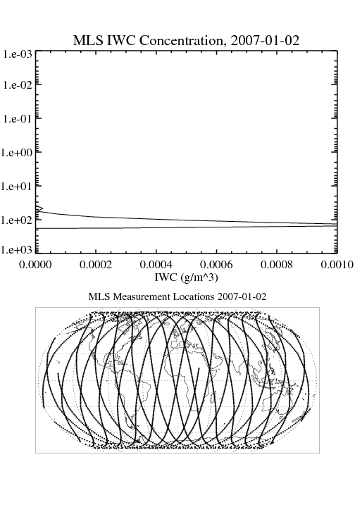
Federal
MLS/Aura Level 2 Cloud Ice Product V004 (ML2IWC) at GES DISC
National Aeronautics and Space Administration —
ML2IWC is the EOS Aura Microwave Limb Sounder (MLS) standard product for cloud ice water content derived from radiances measured by the 240 GHz radiometer. The data... -
Federal
GHRSST NOAA/STAR GOES-17 ABI L3C America Region SST v2.71 dataset in GDS2
National Aeronautics and Space Administration —
The ACSPO G17/ABI L3C (Level 3 Collated) product is a gridded version of the ACSPO G17/ABI L2P product available at... -
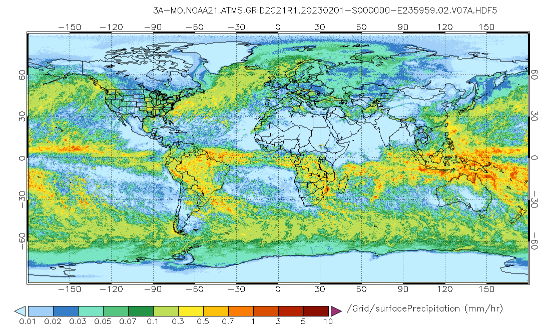
Federal
GPM ATMS on NOAA-21 (GPROF) Radiometer Precipitation Profiling L3 1 month 0.25 degree x 0.25 degree V07 (GPM_3GPROFNOAA21ATMS) at GES DISC
National Aeronautics and Space Administration —
Version 07 is the current version of the data set. 3GPROF products provide global gridded monthly/daily precipitation averages from multiple satellites that can be... -
Federal
Marine angler expenditures 2006 (NCEI Accession 0145343)
National Oceanic and Atmospheric Administration, Department of Commerce —
Angler expenditures for their most recent trip in 2006, by fishing mode - for-hire, private boat, shore. Includes categories such as bait, ice, fuel, lodging, meals,...

Official websites use .gov
A
.gov website belongs to an official government
organization in the United States.
Secure .gov websites use HTTPS
A
lock (
) or https:// means you’ve safely connected to
the .gov website. Share sensitive information only on official,
secure websites.