NOAA Next Generation Radar (NEXRAD) Level 3 Products
Access & Use Information
Downloads & Resources
-
NCEI Dataset Landing Page
Landing page for the dataset.
-
NCEI NEXRAD page
Informational resources for NEXRAD Radar Data.
-
NCEI Data Search
Search the data archive to submit an order via the interface or download...
-
NCEI GIS Map Viewer
Dynamic GIS mapping application to locate stations and data for selected layers.
-
NCEI NEXRAD Data Inventory Search
Search for radar data and estimated VCP mode by station ID, location, and...
-
NCEI ArcGIS REST Services DirectoryEsri REST
ArcGIS Server REST API for the dataset.
-
NCEI NEXRAD WMSWMS
Web Map Service for the dataset.
-
NCEI NEXRAD WFSWFS
Web Feature Service for the dataset.
-
KMZ file for datasetKML
Direct download link for KMZ file.
-
NEXRAD Display and Conversion Tools
Information on free visualization, analysis, and decoding tools for the radar...
-
NOAA National Centers for Environmental...
NCEI home page with information, data access and contact information.
-
Global Change Master Directory (GCMD) Keywords
The information provided on this page seeks to define how the GCMD Keywords...
-
Global Change Master Directory (GCMD) Keywords
The information provided on this page seeks to define how the GCMD Keywords...
-
Global Change Master Directory (GCMD) Keywords
The information provided on this page seeks to define how the GCMD Keywords...
-
Global Change Master Directory (GCMD) Keywords
The information provided on this page seeks to define how the GCMD Keywords...
-
Global Change Master Directory (GCMD) Keywords
The information provided on this page seeks to define how the GCMD Keywords...
-
Global Change Master Directory (GCMD) Keywords
The information provided on this page seeks to define how the GCMD Keywords...
-
Global Change Master Directory (GCMD) Keywords
The information provided on this page seeks to define how the GCMD Keywords...
-
DSMR Publication at the NOAA Institutional Repository
Report documenting the Scientific Data Stewardship Maturity for this dataset.
-
NEXRAD WSR-88D Interface Control Documents
The Interface Control Documents (ICDs) describe the data format specification...
-
Federal Meteorological Handbook No. 11 -...HTML
The Handbook defines standardized data management practices.
-
The WSR-88D and the WSR-88D Operational...
AMS Journal Publication.
-
History of Operational Use of Weather Radar by...
AMS Journal Publication.
-
History of Operational Use of Weather Radar by...
AMS Journal Publication.
Dates
| Metadata Date | August 22, 2023 |
|---|---|
| Metadata Created Date | October 28, 2022 |
| Metadata Updated Date | August 25, 2023 |
| Reference Date(s) | 1992 (publication) |
| Frequency Of Update | continual |
Metadata Source
- ISO-19139 ISO-19139 Metadata
Harvested from ncdc
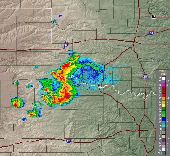
Graphic Preview

Additional Metadata
| Resource Type | Dataset |
|---|---|
| Metadata Date | August 22, 2023 |
| Metadata Created Date | October 28, 2022 |
| Metadata Updated Date | August 25, 2023 |
| Reference Date(s) | 1992 (publication) |
| Responsible Party | NOAA National Centers for Environmental Information (Point of Contact) |
| Contact Email | |
| Guid | gov.noaa.ncdc:C00708 |
| Access Constraints | Cite as: NOAA National Weather Service (NWS) Radar Operations Center (1992): NOAA Next Generation Radar (NEXRAD) Level 3 Products. [indicate subset used]. NOAA National Centers for Environmental Information. NCEI DSI 7000. [access date]., Distribution liability: NOAA and NCEI make no warranty, expressed or implied, regarding these data, nor does the fact of distribution constitute such a warranty. NOAA and NCEI cannot assume liability for any damages caused by any errors or omissions in these data. If appropriate, NCEI can only certify that the data it distributes are an authentic copy of the records that were accepted for inclusion in the NCEI archives., Use liability: NOAA and NCEI cannot provide any warranty as to the accuracy, reliability, or completeness of furnished data. Users assume responsibility to determine the usability of these data. The user is responsible for the results of any application of this data for other than its intended purpose. |
| Bbox East Long | -64.0 |
| Bbox North Lat | 68.0 |
| Bbox South Lat | 11.0 |
| Bbox West Long | 124.0 |
| Coupled Resource | |
| Frequency Of Update | continual |
| Graphic Preview Description | NEXRAD reflectivity image |
| Graphic Preview File | https://www.ncei.noaa.gov/pub/data/metadata/images/C00708_fdr_baserefl.jpg |
| Graphic Preview Type | JPEG |
| Harvest Object Id | 04c8d447-2590-4bb0-949a-fd91094a6c8e |
| Harvest Source Id | 2cb3ef77-1683-4c2a-9119-dc65e50917c6 |
| Harvest Source Title | ncdc |
| Licence | |
| Lineage | NEXRAD Level 3 products were created by the NOAA National Weather Service (NWS) and are archived by the NOAA National Centers for Environmental Information (NCEI). |
| Metadata Language | eng; USA |
| Metadata Type | geospatial |
| Old Spatial | {"type": "Polygon", "coordinates": [[[124.0, 11.0], [-64.0, 11.0], [-64.0, 68.0], [124.0, 68.0], [124.0, 11.0]]]} |
| Progress | onGoing |
| Spatial Data Service Type | |
| Spatial Reference System | |
| Spatial Harvester | True |
| Temporal Extent Begin | 1992-05-07 |
Didn't find what you're looking for? Suggest a dataset here.

