Summary of the ABoVE L-band and P-band Airborne SAR Surveys, 2012-2022
Access & Use Information
Downloads & Resources
-
Google Scholar search resultsHTML
Search results for publications that cite this dataset by its DOI.
-
Download this datasetHTML
This link allows direct data access via Earthdata login
-
View documentation related to this datasetHTML
ORNL DAAC Data Set Documentation
-
This dataset's landing pageHTML
Data set Landing Page DOI URL
-
View documentation related to this datasetPDF
Summary of the ABoVE L-band and P-band Airborne SAR Surveys, 2012-2022:...
-
Get a related visualizationJPEG
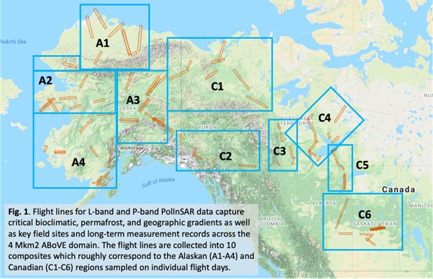
Flight lines for L-band and P-band PolInSAR measurements capture critical...
-
The dataset's project home pageHTML
ABoVE project site
-
Landing PageLanding Page
Dates
| Metadata Created Date | October 25, 2023 |
|---|---|
| Metadata Updated Date | December 6, 2023 |
Metadata Source
- Data.json Data.json Metadata
Harvested from NASA Data.json
Graphic Preview

Additional Metadata
| Resource Type | Dataset |
|---|---|
| Metadata Created Date | October 25, 2023 |
| Metadata Updated Date | December 6, 2023 |
| Publisher | ORNL_DAAC |
| Maintainer | |
| Identifier | C2787699093-ORNL_CLOUD |
| Data First Published | 2023-10-20 |
| Language | en-US |
| Data Last Modified | 2023-10-22 |
| Category | ABoVE, geospatial |
| Public Access Level | public |
| Bureau Code | 026:00 |
| Metadata Context | https://project-open-data.cio.gov/v1.1/schema/catalog.jsonld |
| Metadata Catalog ID | https://data.nasa.gov/data.json |
| Schema Version | https://project-open-data.cio.gov/v1.1/schema |
| Catalog Describedby | https://project-open-data.cio.gov/v1.1/schema/catalog.json |
| Citation | Miller, C.E., P. Griffith, E.E. Hoy, N. Pinto, Y. Lou, S. Hensley, B. Chapman, J.L. Baltzer, K. Bakian-Dogaheh, W.R. Bolton, L.L. Bourgeau-Chavez, R.H. Chen, B-H. Choe, L.K. Clayton, T.A. Douglas, N.H.F. French, J.E. Holloway, G. Hong, L. Huang, G. Iwahana, L.K. Jenkins, J.S. Kimball, T.V. Loboda, M.C. Mack, P. Marsh, R.J. Michaelides, M. Moghaddam, A.D. Parsekian, K. Schaefer, P. Siqueira, D. Singh, A. Tabatabaeenejad, M.R. Turetsky, R. Touzi, E. Wig, P. Wilson, C.J. Wilson, S.D. Wullschleger, Y. Yi, H.A. Zebker, Y. Zhang, Y. Zhao, and S.J. Goetz. 2023. Summary of the ABoVE L-band and P-band Airborne SAR Surveys, 2012-2022. ORNL DAAC, Oak Ridge, Tennessee, USA. https://doi.org/10.3334/ORNLDAAC/2150 |
| Graphic Preview Description | Flight lines for L-band and P-band PolInSAR measurements capture critical bioclimatic, permafrost, and geographic gradients as well as key field sites and long-term measurement records across the ABoVE domain. The flight lines are collected into 10 composites which roughly correspond to the Alaskan (A1-A4) and Canadian (C1-C6) regions sampled on individual flight days. Basemap source: Google Maps. |
| Graphic Preview File | https://daac.ornl.gov/ABOVE/guides/ABoVE_SAR_Surveys_Fig1.jpg |
| Harvest Object Id | b3f45307-b160-4892-973f-6a9ad57b806d |
| Harvest Source Id | 58f92550-7a01-4f00-b1b2-8dc953bd598f |
| Harvest Source Title | NASA Data.json |
| Homepage URL | https://doi.org/10.3334/ORNLDAAC/2150 |
| Metadata Type | geospatial |
| Old Spatial | -169.0 50.0 -102.0 72.0 |
| Program Code | 026:001 |
| Source Datajson Identifier | True |
| Source Hash | cd4869545d503eccf787f511d6f3e7eeaadbff5e774c0873070d1be0d2863be5 |
| Source Schema Version | 1.1 |
| Spatial | |
| Temporal | 2012-01-01T00:00:00Z/2022-12-31T23:59:59Z |
Didn't find what you're looking for? Suggest a dataset here.

