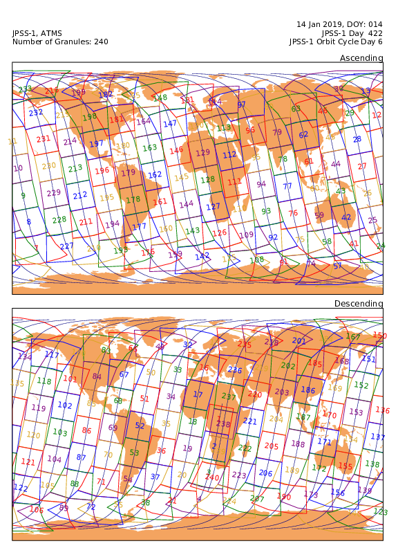
Sounder SIPS: JPSS-1 ATMS Level 1 Daily Polygon Granule Map at GES DISC
Access & Use Information
Downloads & Resources
-
Google Scholar search resultsHTML
Search results for publications that cite this dataset by its DOI.
-
Get a related visualizationPNG
ATMS.map.png
-
This dataset's landing pageHTML
Access the dataset landing page from the GES DISC website.
-
Download this dataset through a directory mapHTML
Access the data via HTTPS.
-
Download this dataset through Earthdata SearchHTML
Use the Earthdata Search to find and retrieve data sets across multiple data...
-
The dataset's project home pageHTML
Sounder home page at NASA/JPL. General information on instrument, algorithms,...
-
View information related to this datasetHTML
AIRS/Sounder Documentation Page
-
View this dataset's read me documentPDF
README Document
-
Landing PageLanding Page
Dates
| Metadata Created Date | December 1, 2022 |
|---|---|
| Metadata Updated Date | October 22, 2024 |
Metadata Source
- Data.json Data.json Metadata
Harvested from NASA Data.json
Graphic Preview

Additional Metadata
| Resource Type | Dataset |
|---|---|
| Metadata Created Date | December 1, 2022 |
| Metadata Updated Date | October 22, 2024 |
| Publisher | NASA/GSFC/SED/ESD/GCDC/GESDISC |
| Maintainer | |
| Identifier | C2373816920-GES_DISC |
| Data First Published | 2017-12-11 |
| Language | en-US |
| Data Last Modified | 2024-10-16 |
| Category | JPSS, geospatial |
| Public Access Level | public |
| Bureau Code | 026:00 |
| Metadata Context | https://project-open-data.cio.gov/v1.1/schema/catalog.jsonld |
| Metadata Catalog ID | https://data.nasa.gov/data.json |
| Schema Version | https://project-open-data.cio.gov/v1.1/schema |
| Catalog Describedby | https://project-open-data.cio.gov/v1.1/schema/catalog.json |
| Citation | JPL Science Team. 2022-08-10. SNDRJ1ATMSMAP. Version 1. Sounder SIPS: JPSS-1 ATMS Level 1 Daily Polygon Granule Map. Greenbelt, MD, USA. Archived by National Aeronautics and Space Administration, U.S. Government, Goddard Earth Sciences Data and Information Services Center (GES DISC). https://doi.org/10.5067/STS5LCLW320L. https://disc.gsfc.nasa.gov/datacollection/SNDRJ1ATMSMAP_1.html. Digital Science Data. |
| Creator | JPL Science Team |
| Data Presentation Form | Digital Science Data |
| Graphic Preview File | https://docserver.gesdisc.eosdis.nasa.gov/public/project/Images/ATMS.map.png |
| Harvest Object Id | b911e2b2-a698-499a-bfed-991d8be815d8 |
| Harvest Source Id | 58f92550-7a01-4f00-b1b2-8dc953bd598f |
| Harvest Source Title | NASA Data.json |
| Homepage URL | https://doi.org/10.5067/STS5LCLW320L |
| Metadata Type | geospatial |
| Old Spatial | -180.0 -90.0 180.0 90.0 |
| Program Code | 026:001 |
| Release Place | Greenbelt, MD, USA |
| Series Name | SNDRJ1ATMSMAP |
| Source Datajson Identifier | True |
| Source Hash | 04242402d894d23401bd4595b35388c52a6931bf2597d958c534fd9a44864168 |
| Source Schema Version | 1.1 |
| Spatial | |
| Temporal | 2017-11-29T00:00:00Z/2024-10-21T00:00:00Z |
Didn't find what you're looking for? Suggest a dataset here.

