

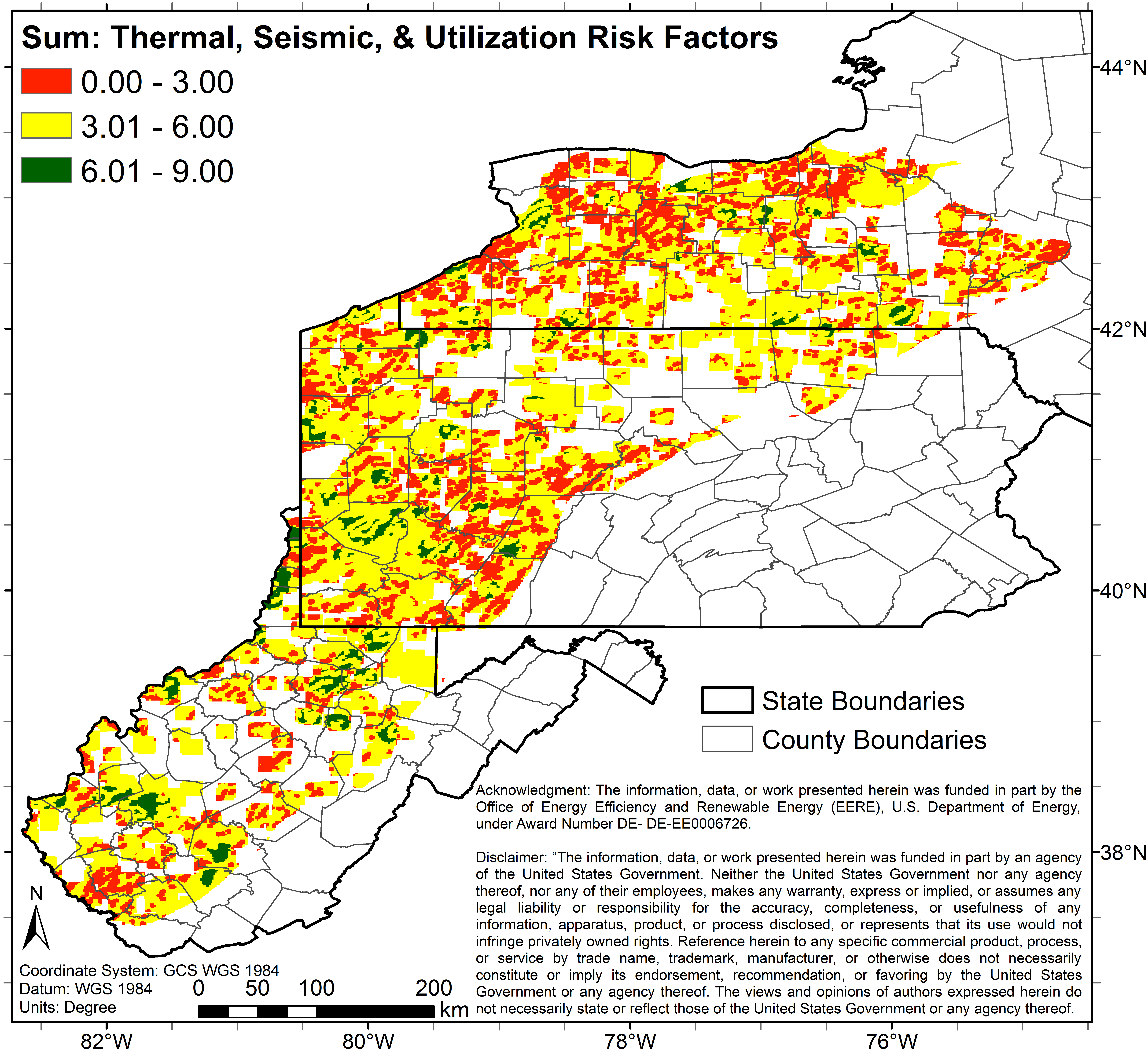
Risk Factor Analysis in Low-Temperature Geothermal Play Fairway Analysis for the Appalachian Basin (GPFA-AB)
Access & Use Information
Downloads & Resources
-
About Data Upload.pdfPDF
Explanation of this submission to the Geothermal Data Repository Node of the...
-
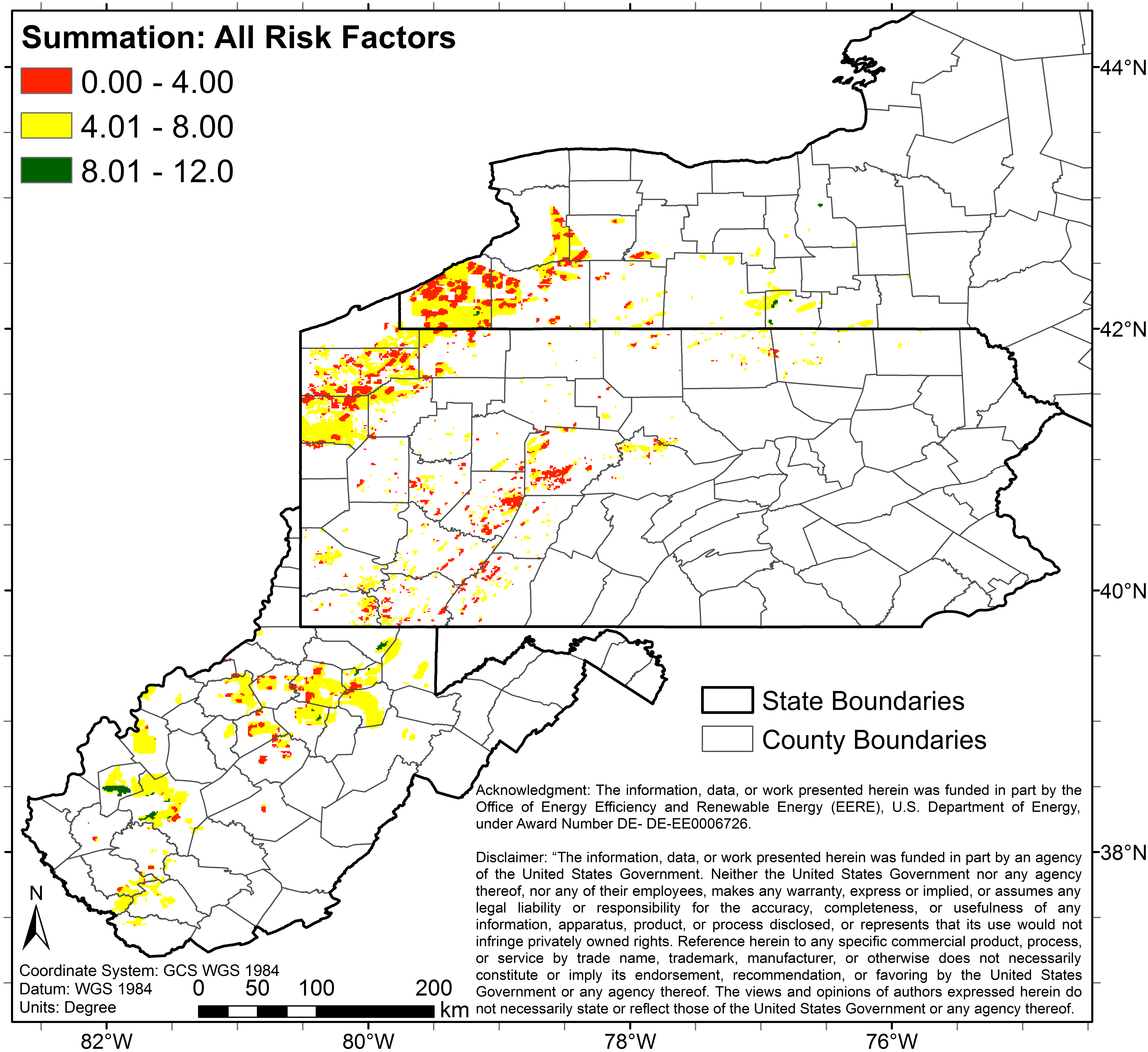
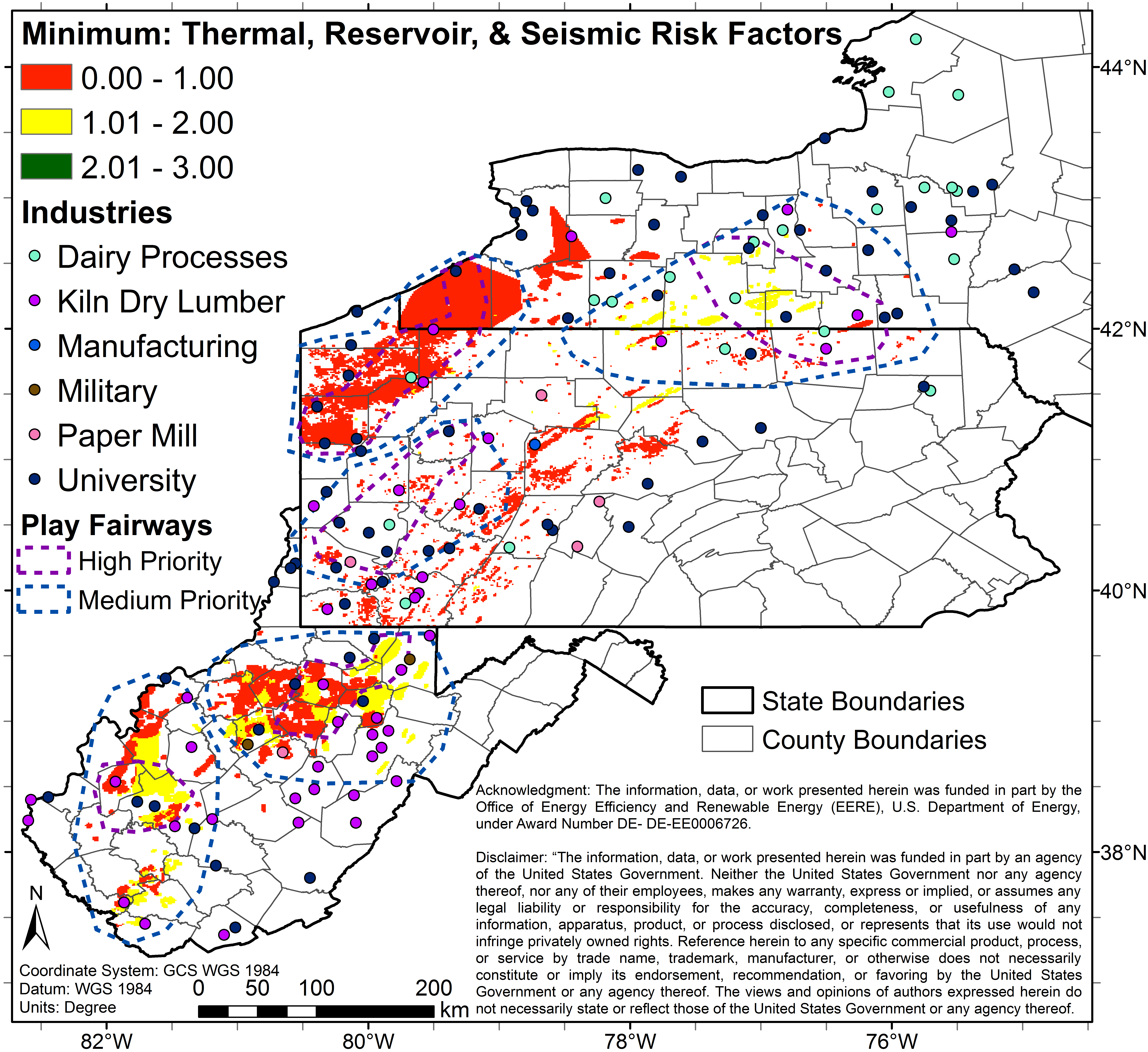
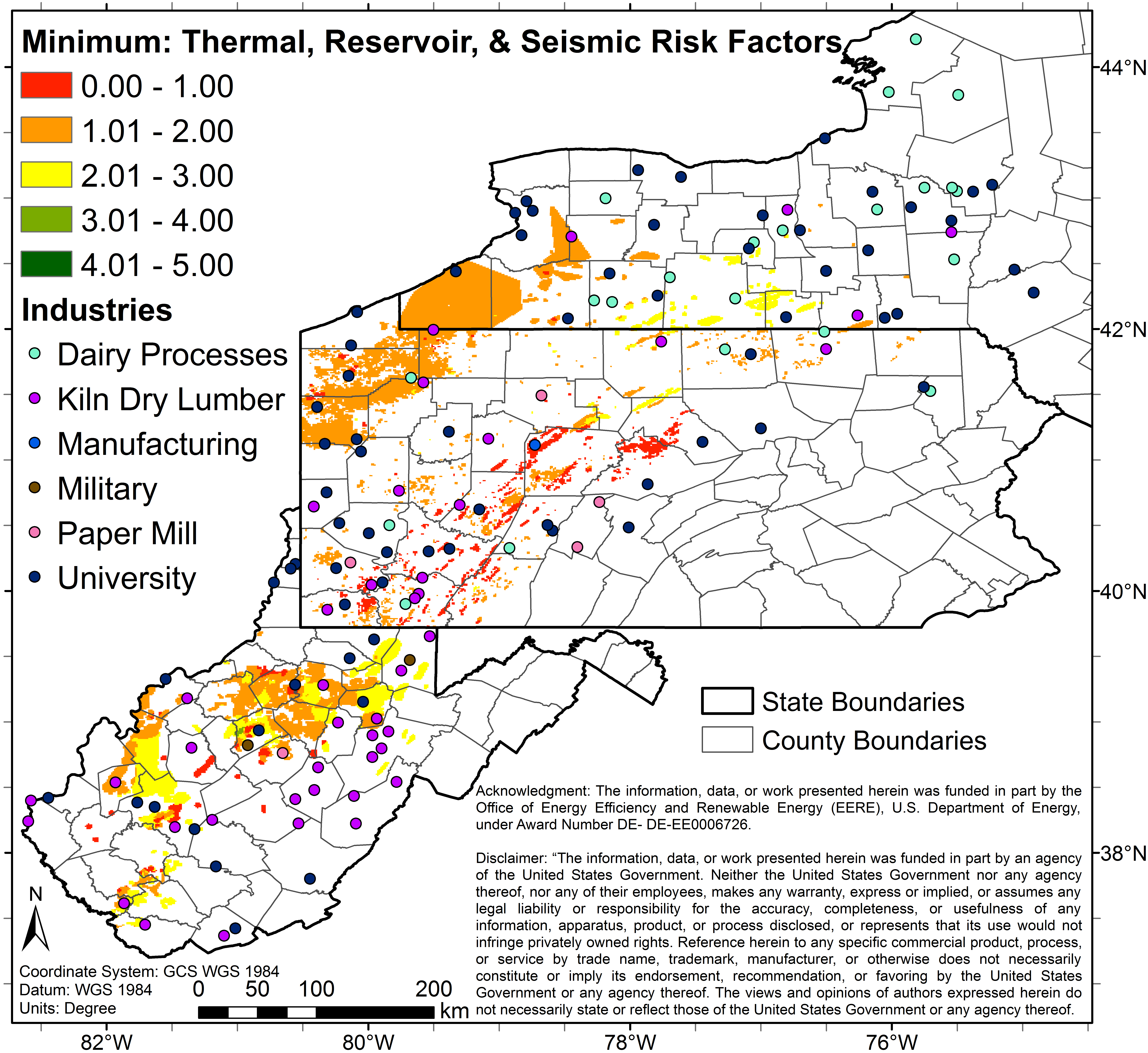
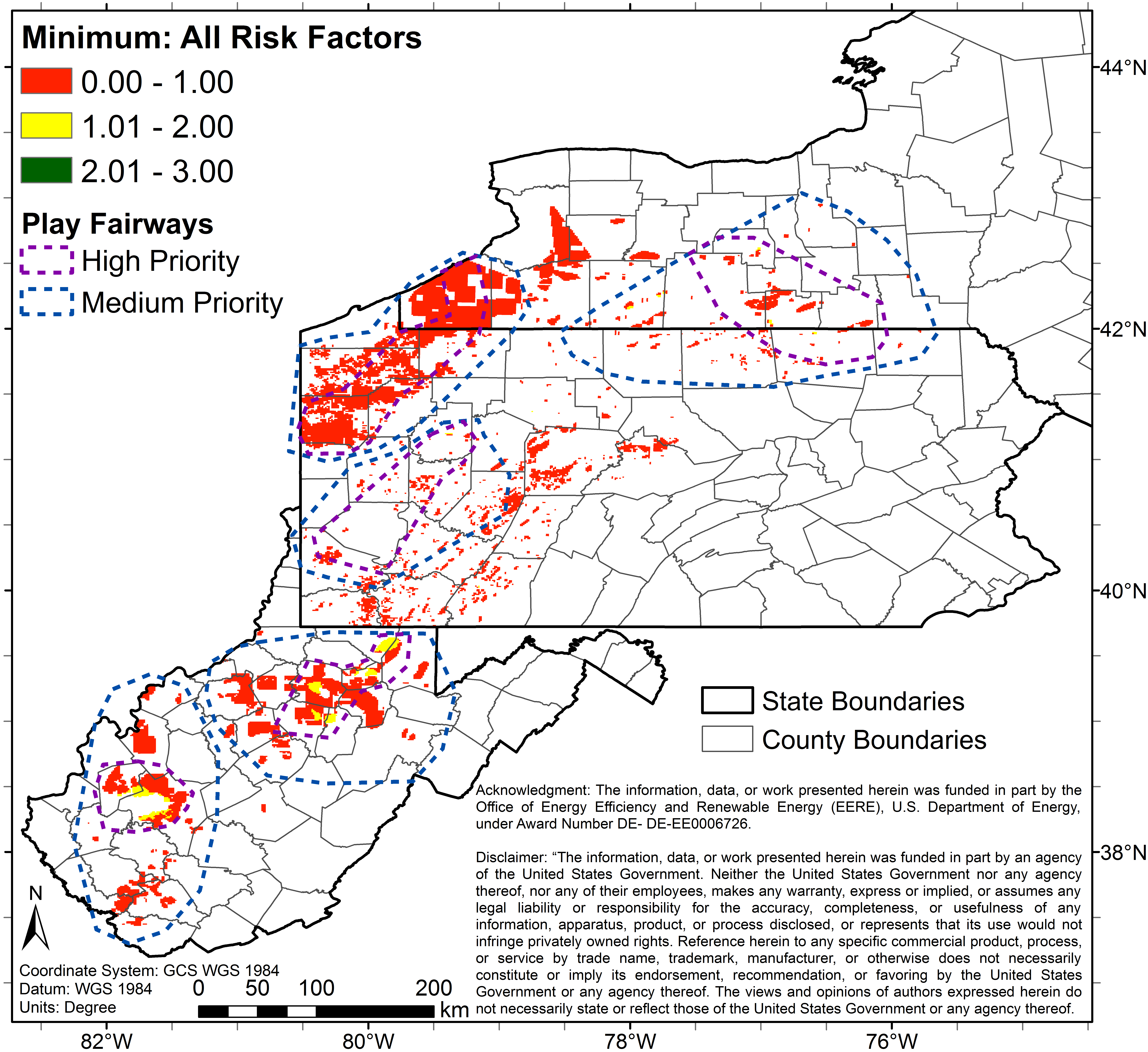
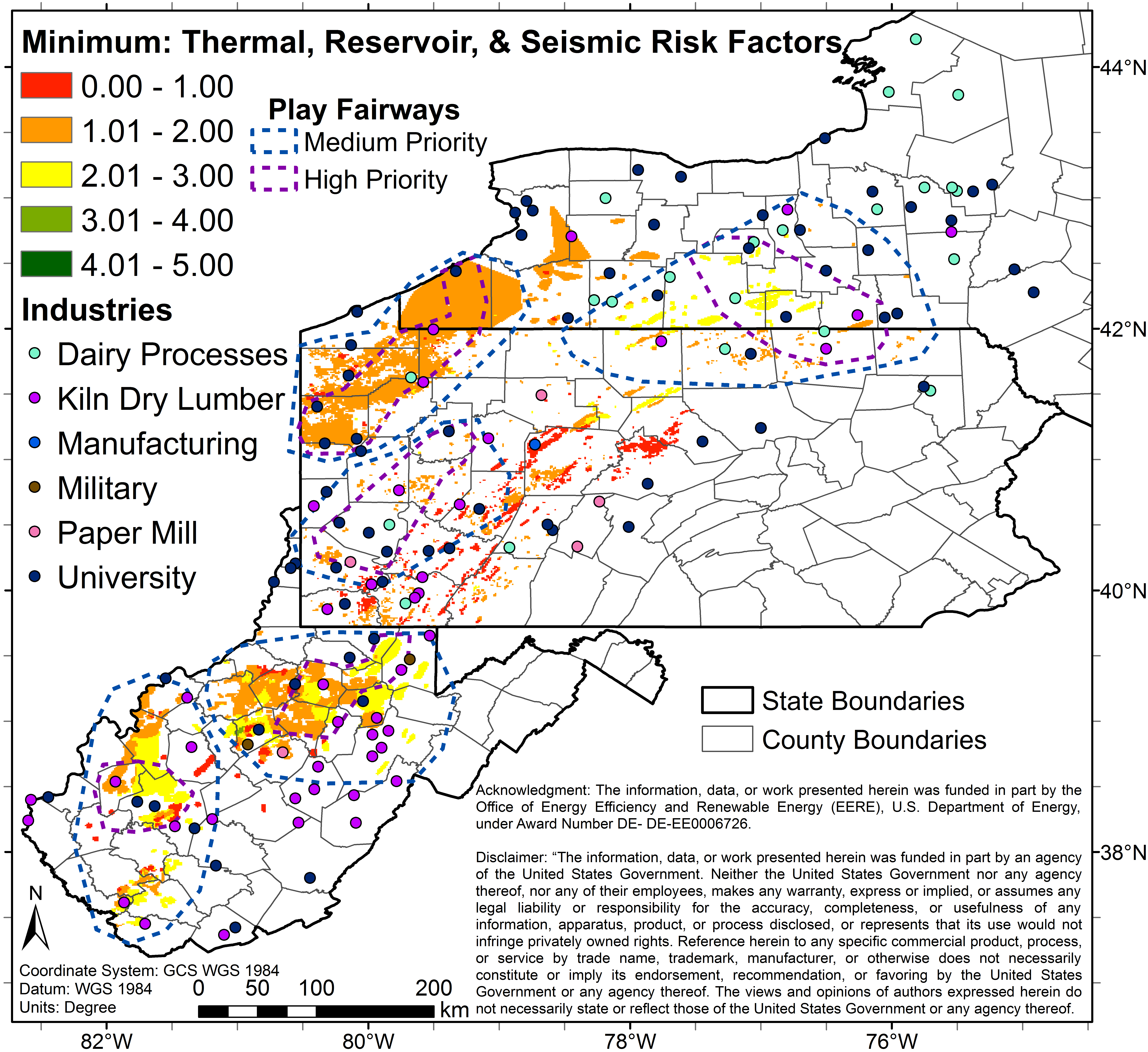
co_3_0_27_p_geo_industries.pngPNG
3 color map (Image File) of study area depicting predicted combined risks...
-
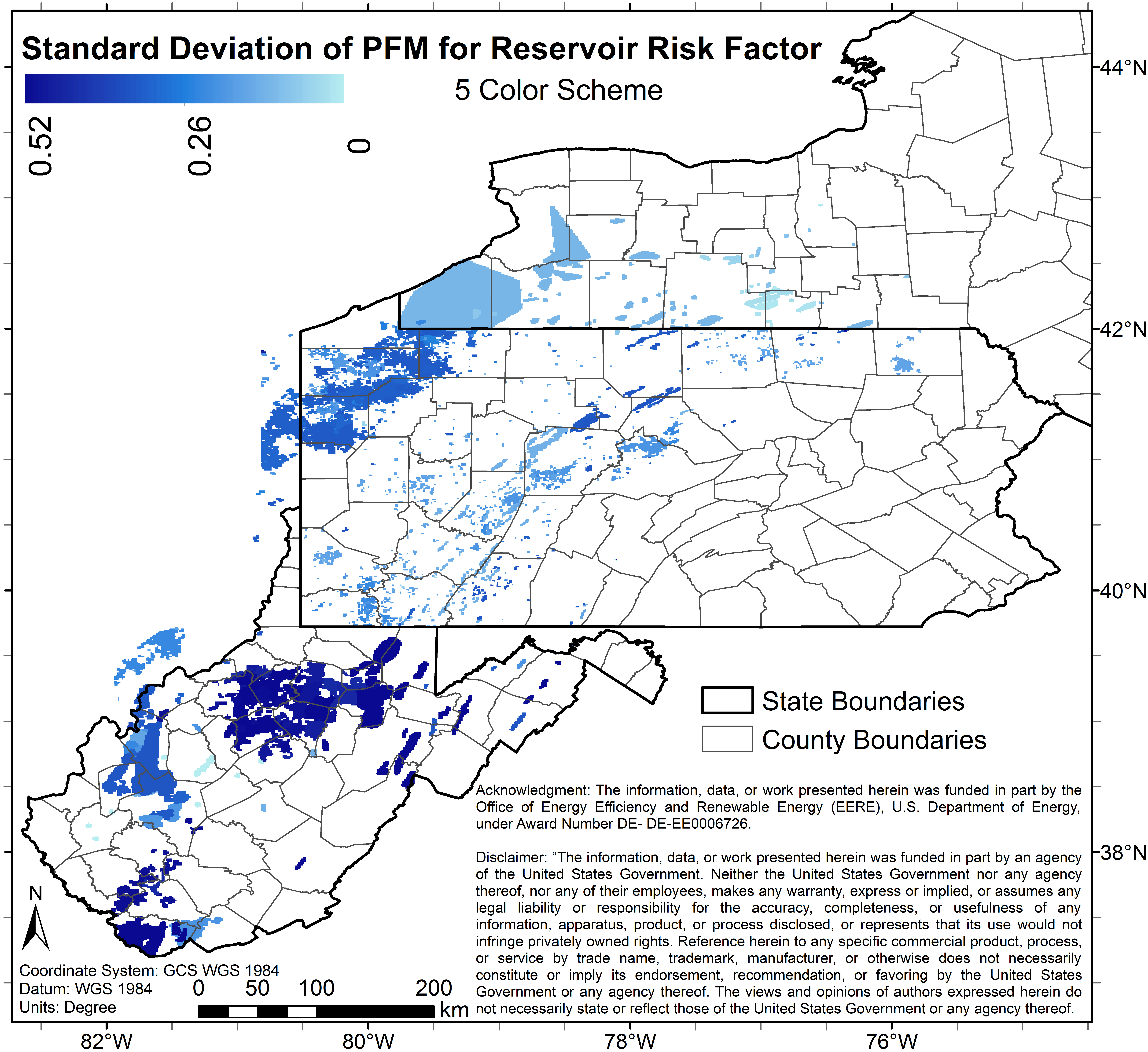
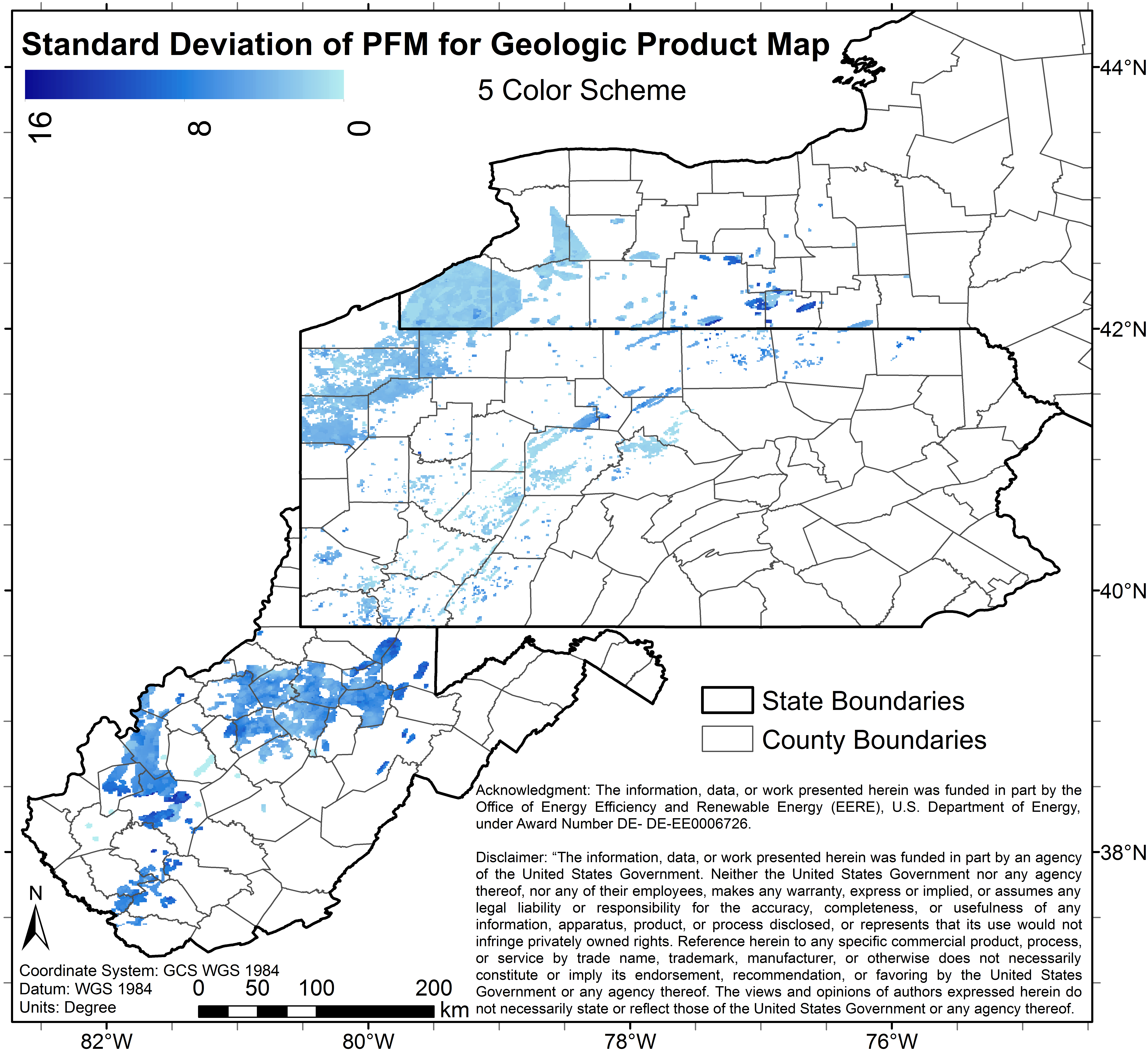
sest_sd5.pngPNG
Image File of the uncertainty (standard deviation) associated with 5 color...
-
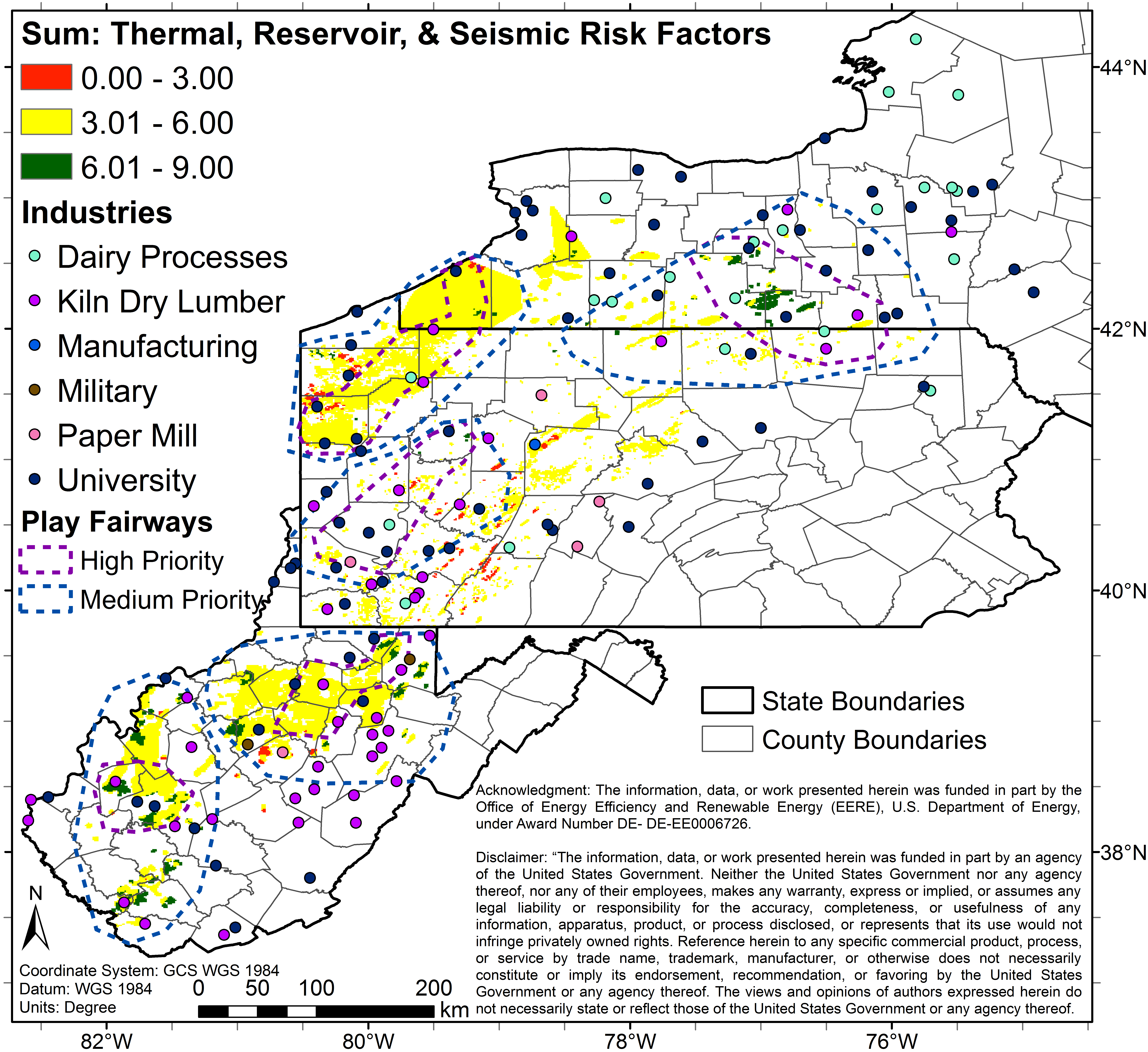
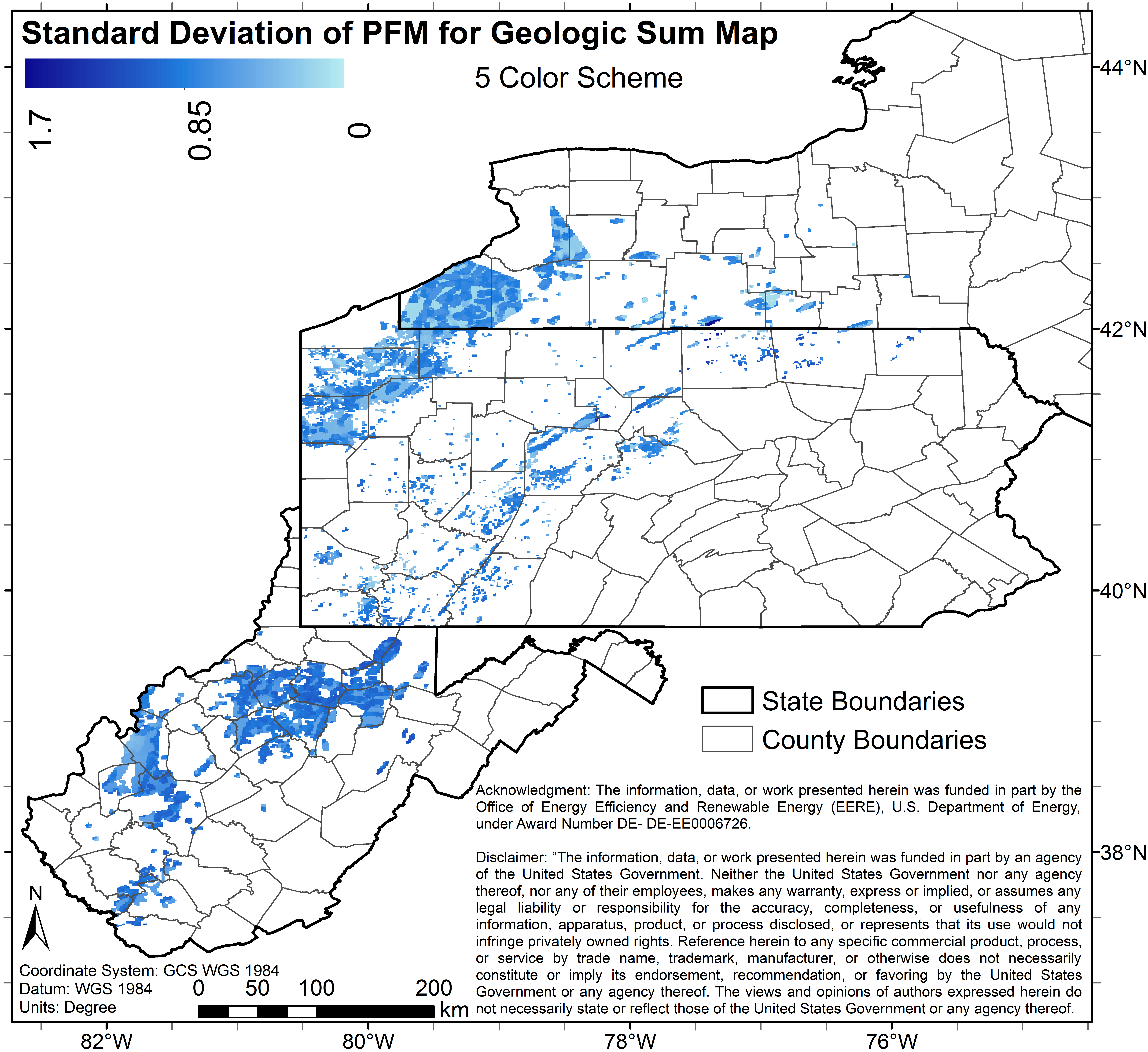
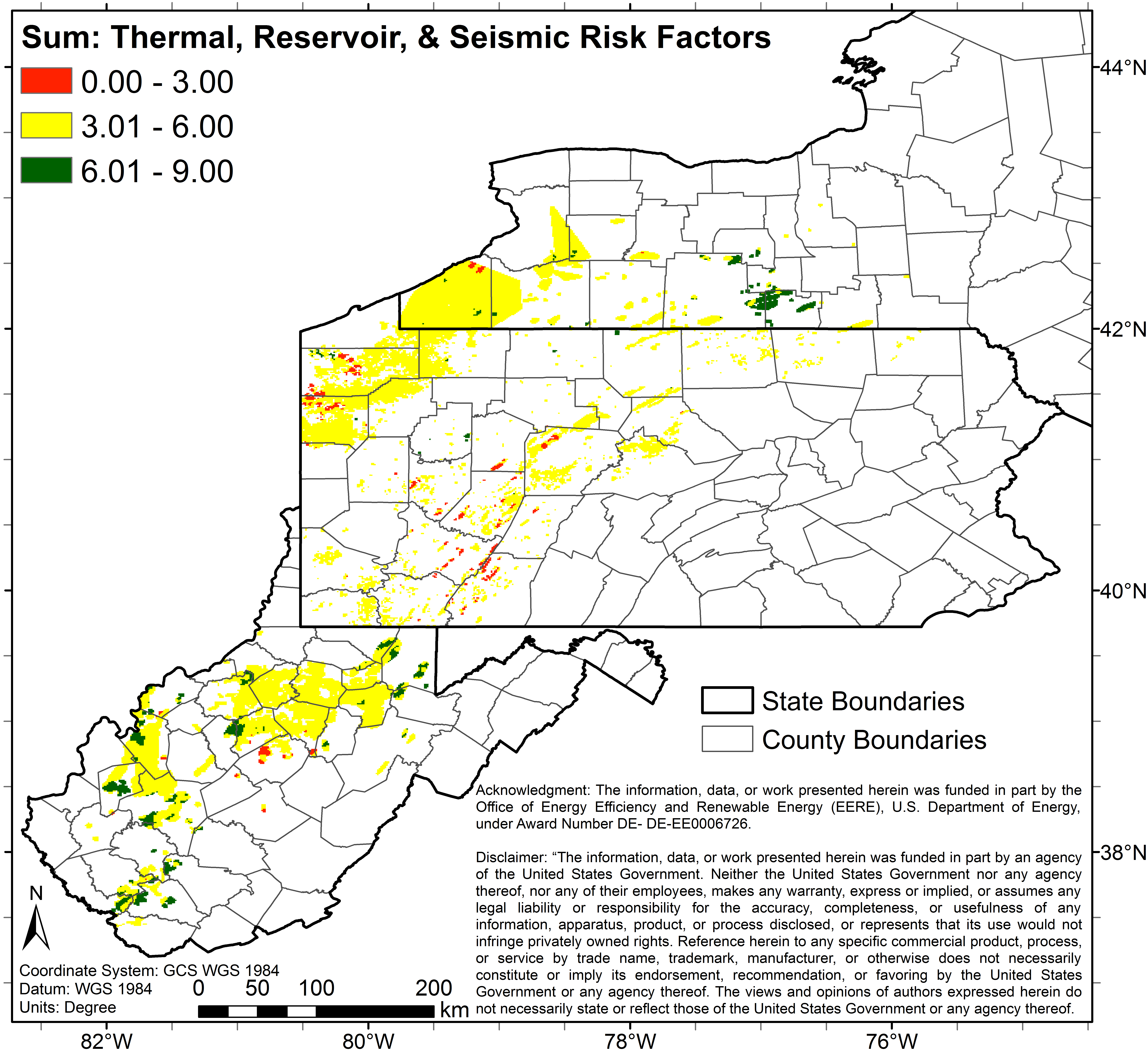
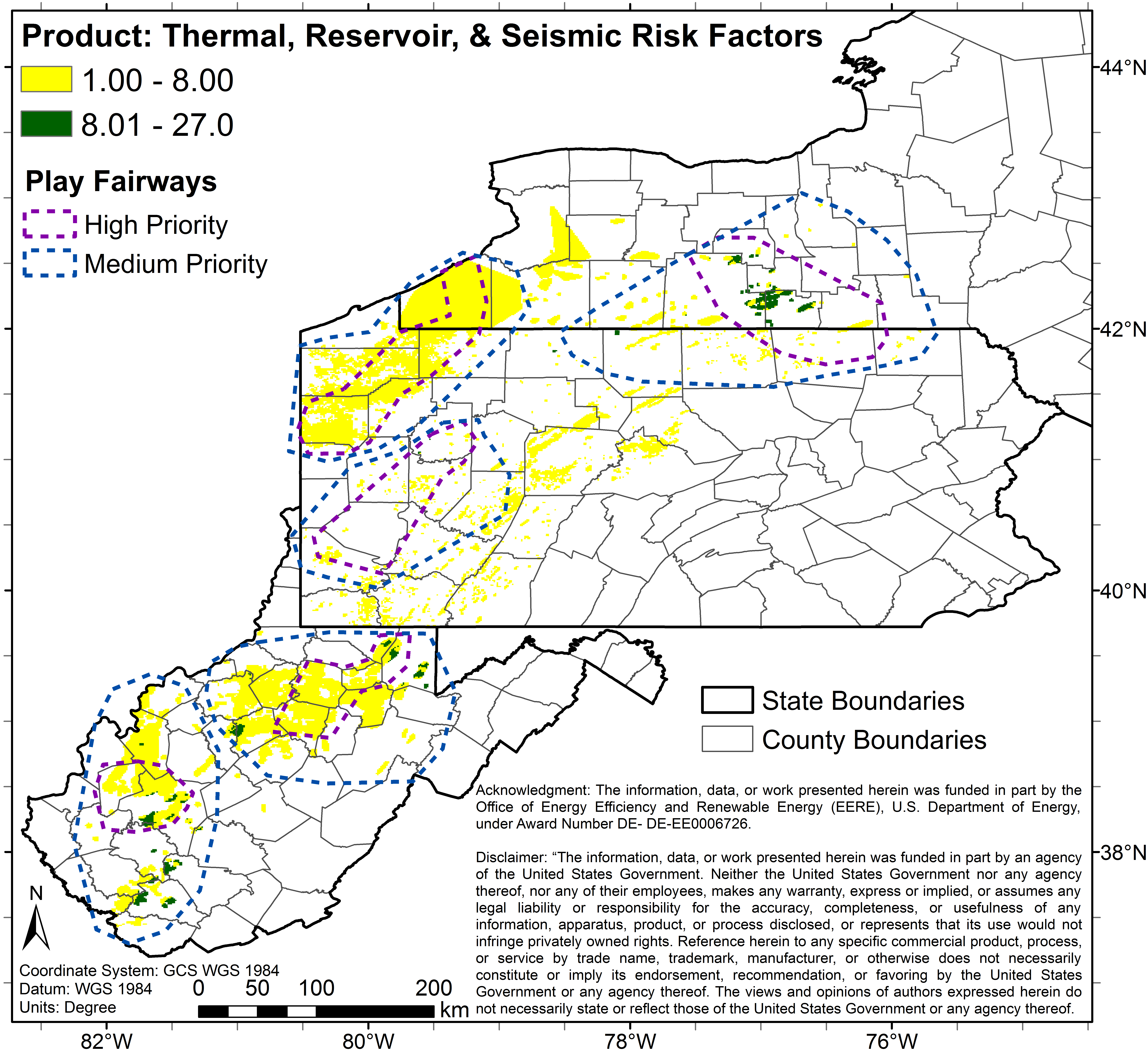
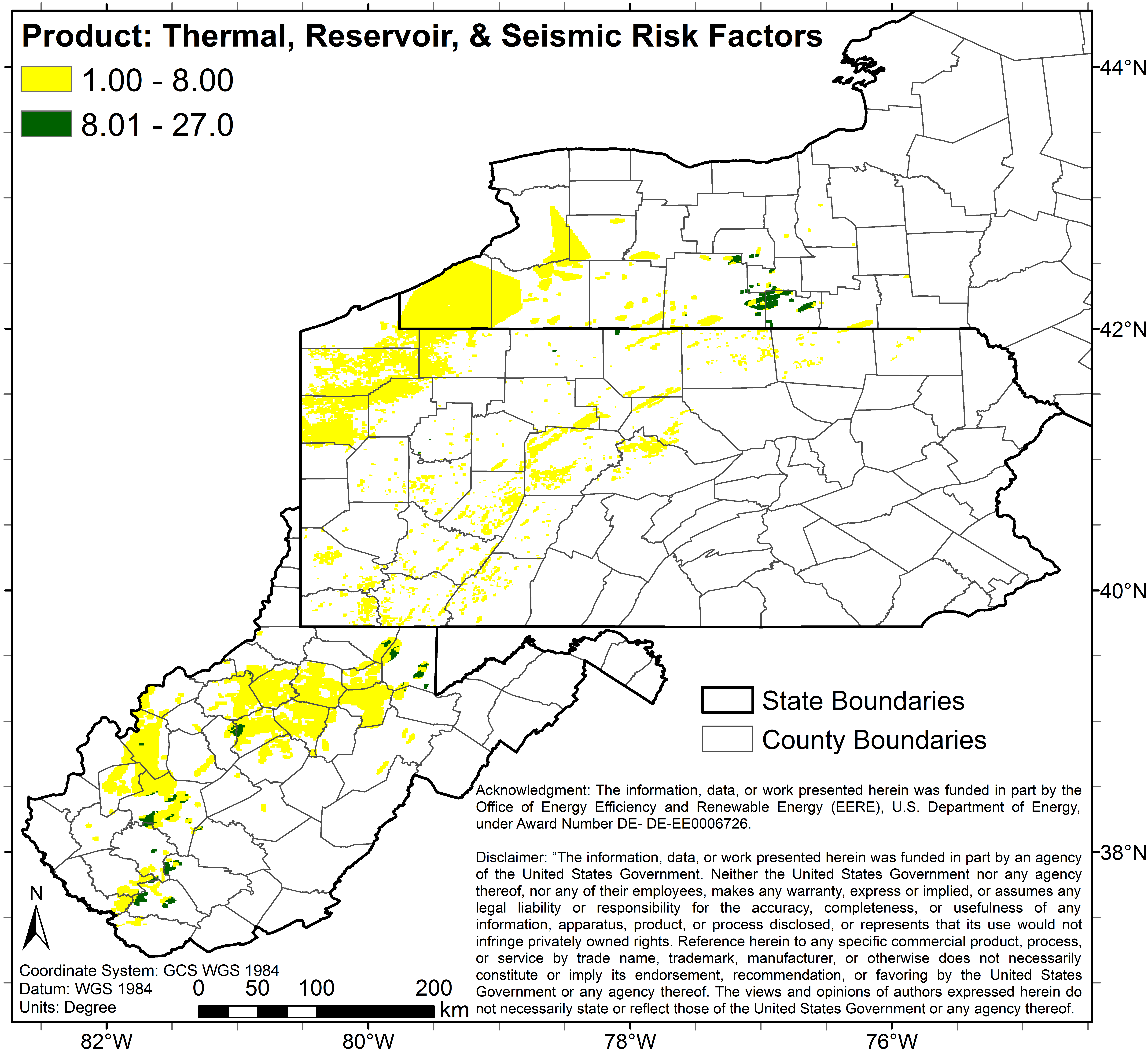
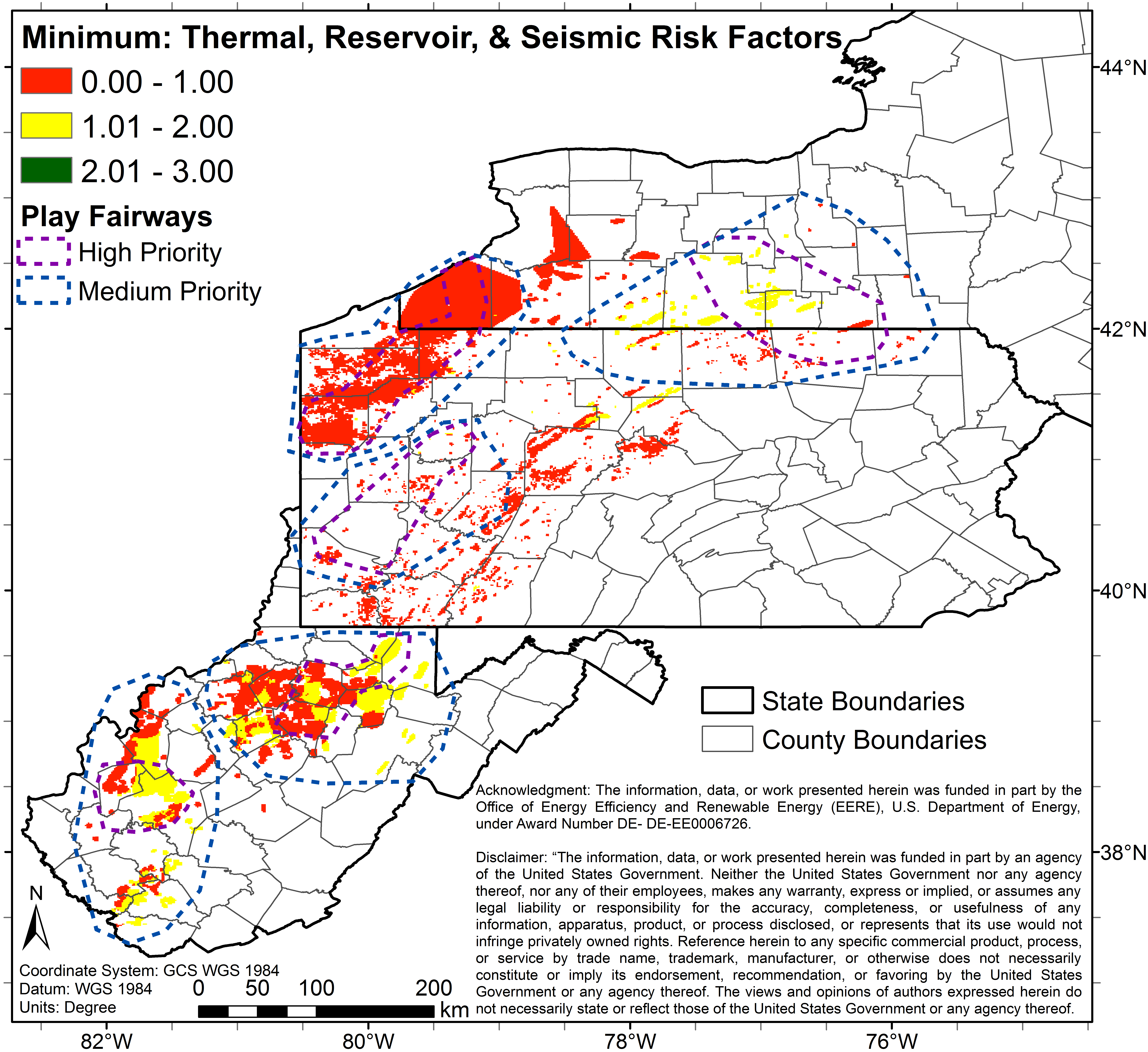
co_5_0_625_p.pngPNG
5 color map (Image File) of study area depicting predicted combined risks...
-
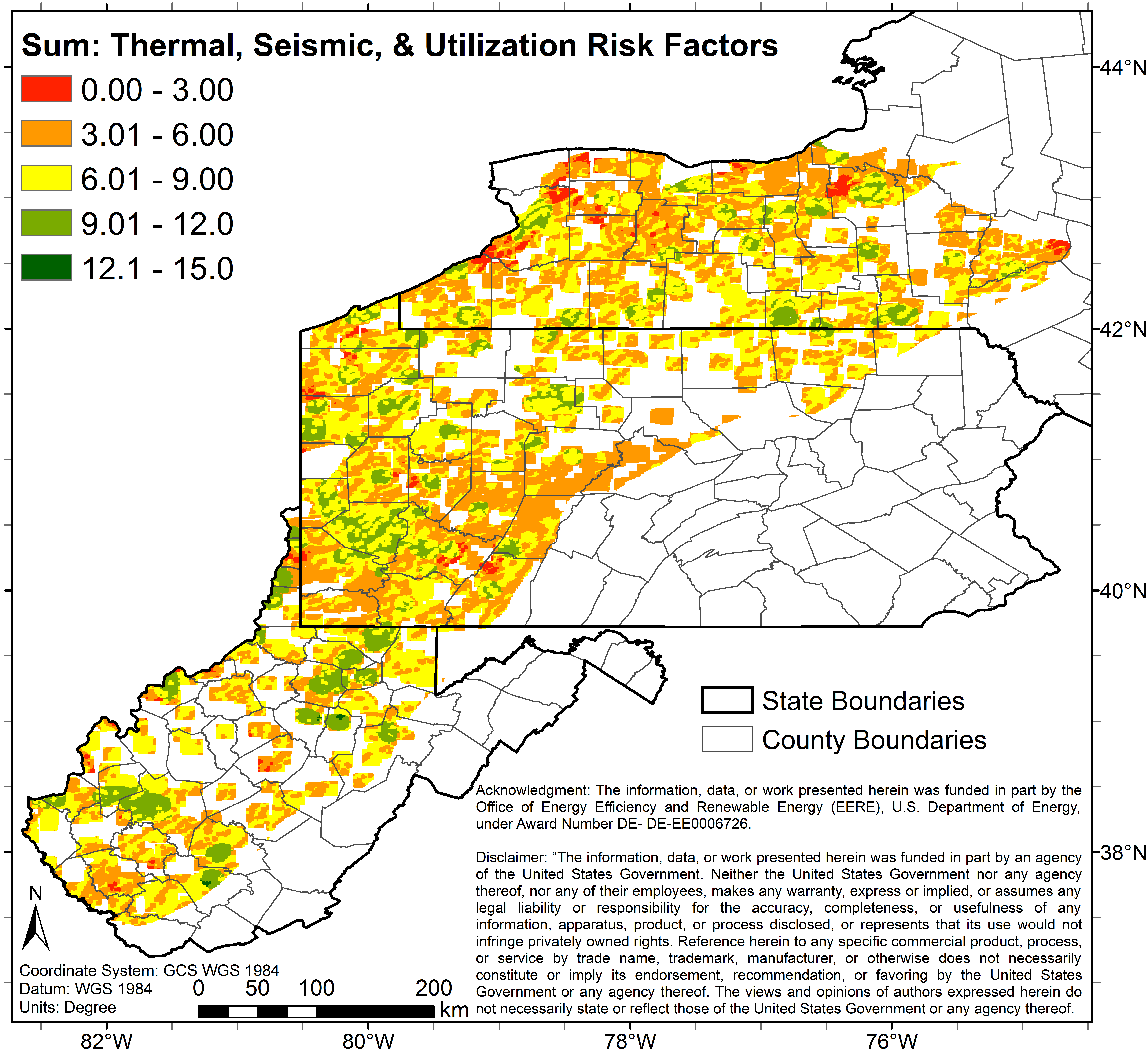
co_5_0_20_s.pngPNG
5 color map (Image File) of study area depicting predicted combined risks...
-
co_pfa_sd3_p_geo.pngPNG
Image File of the uncertainty (standard deviation) associated with the 3...
-
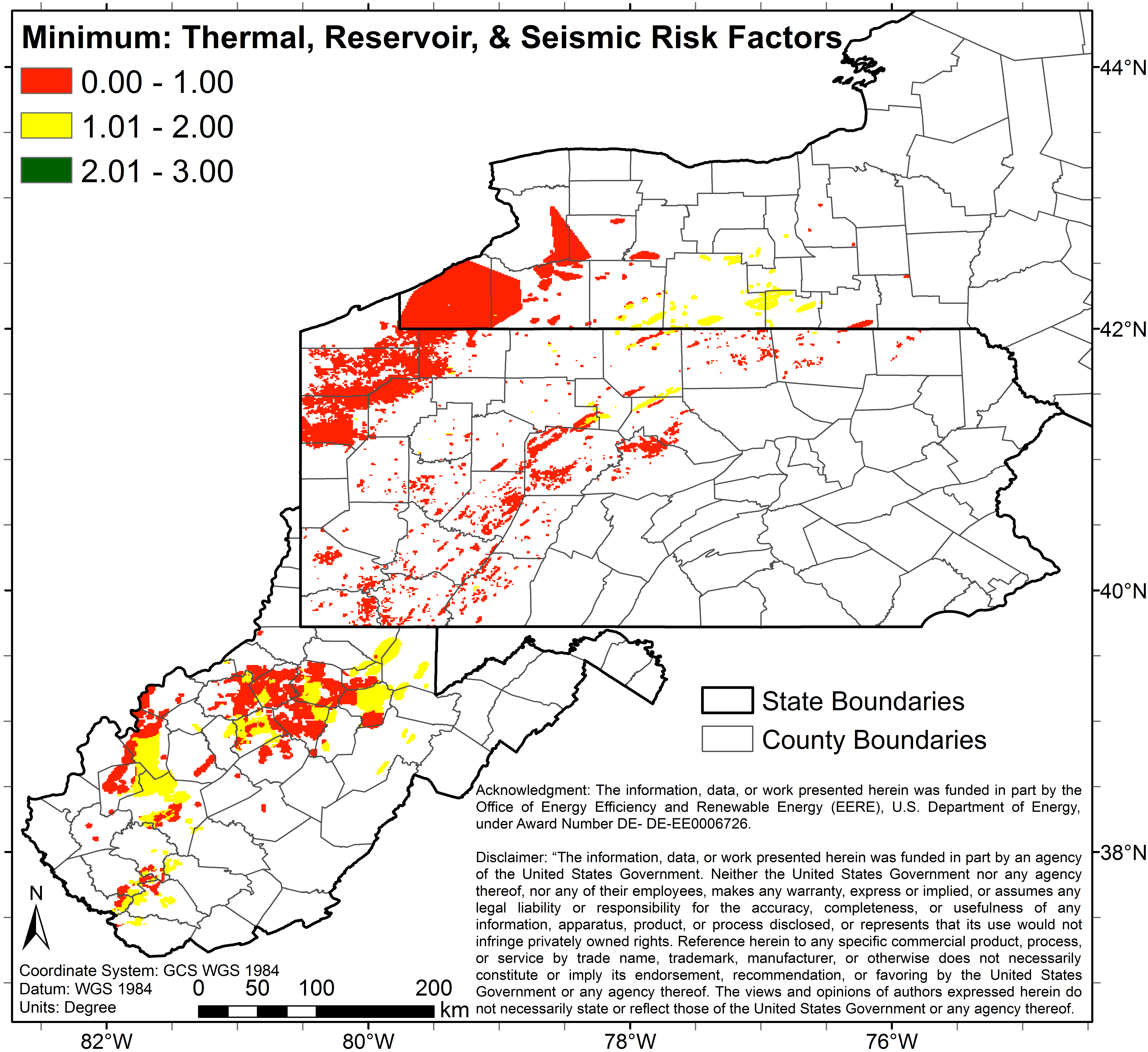
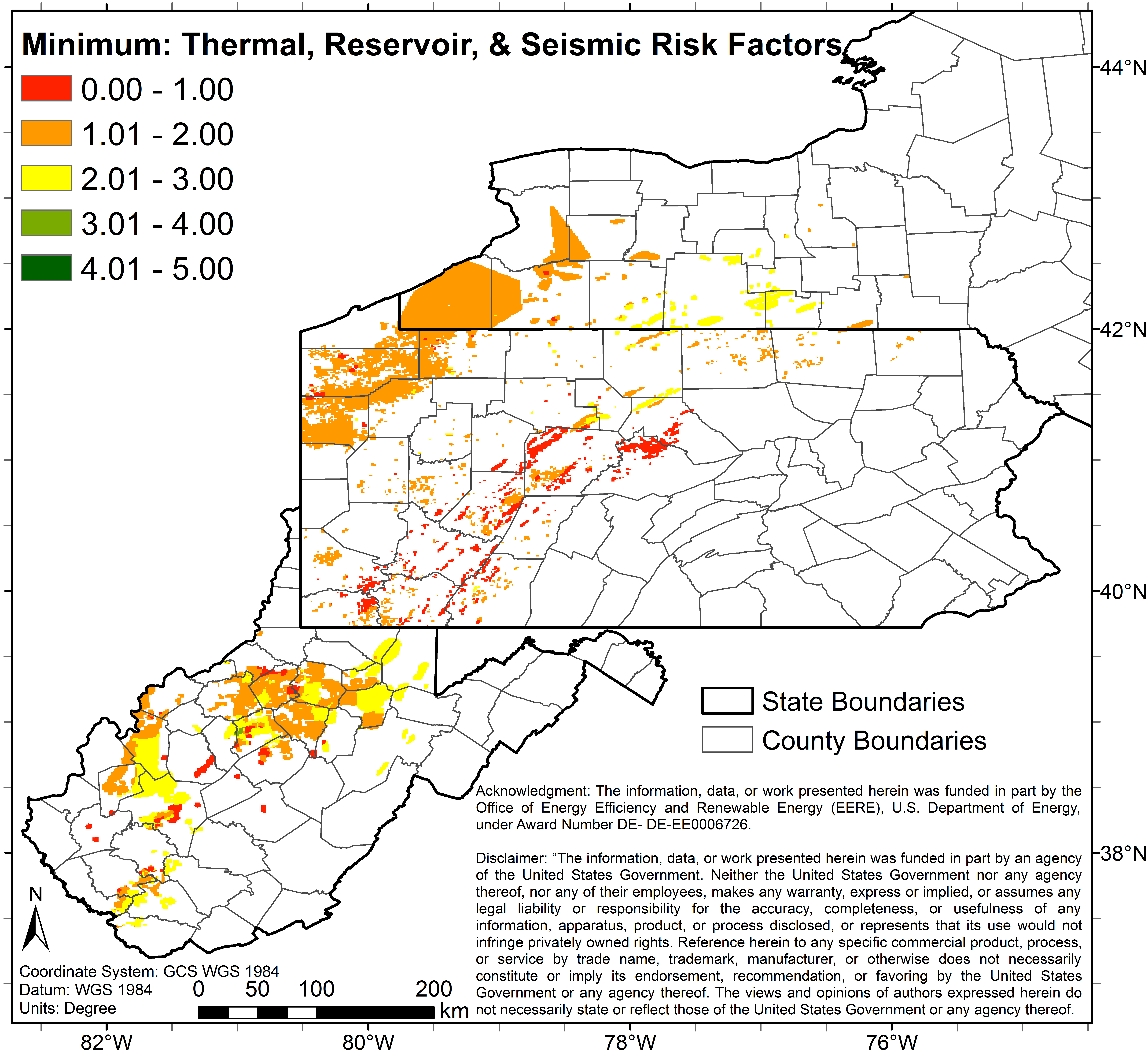
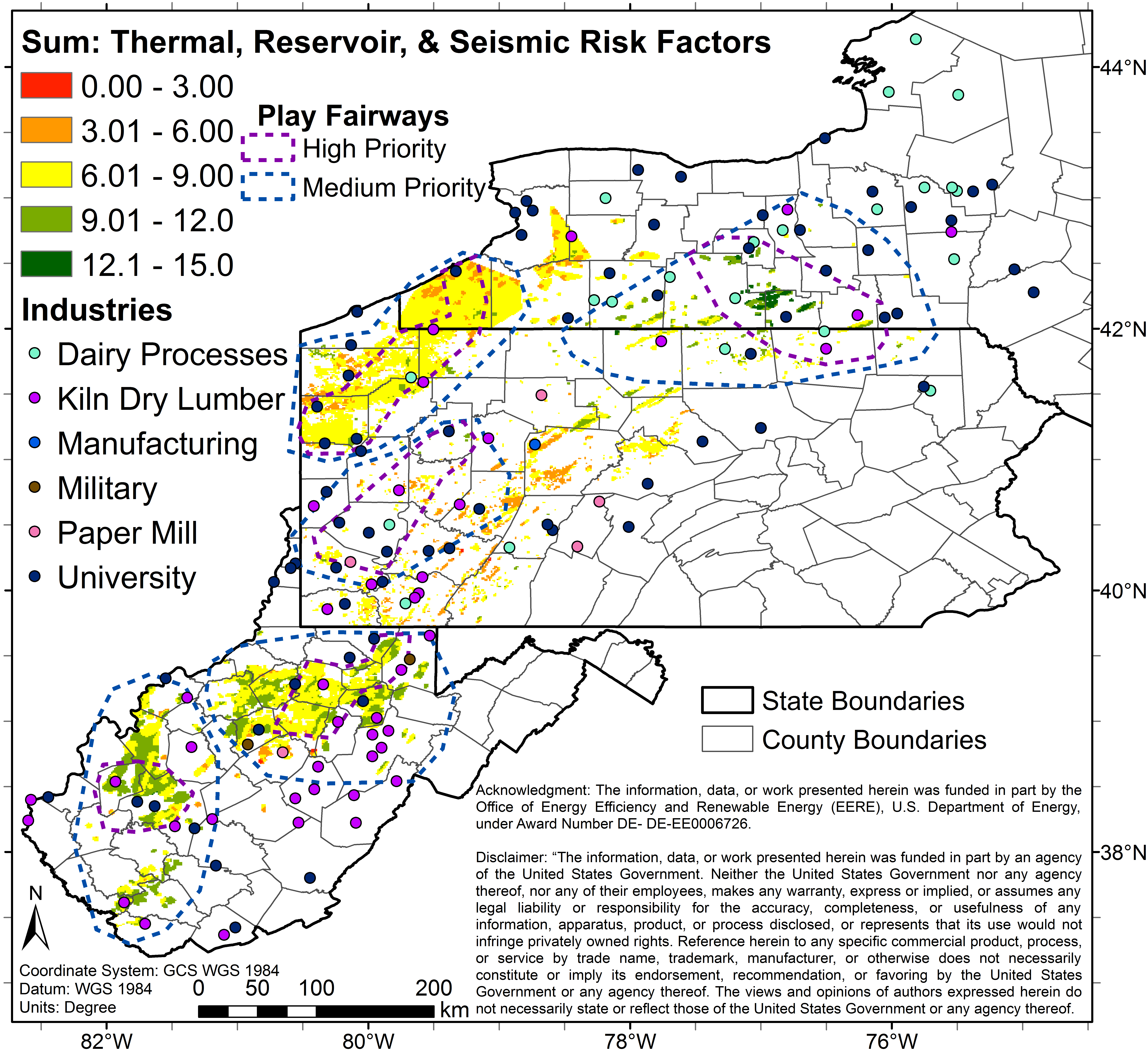
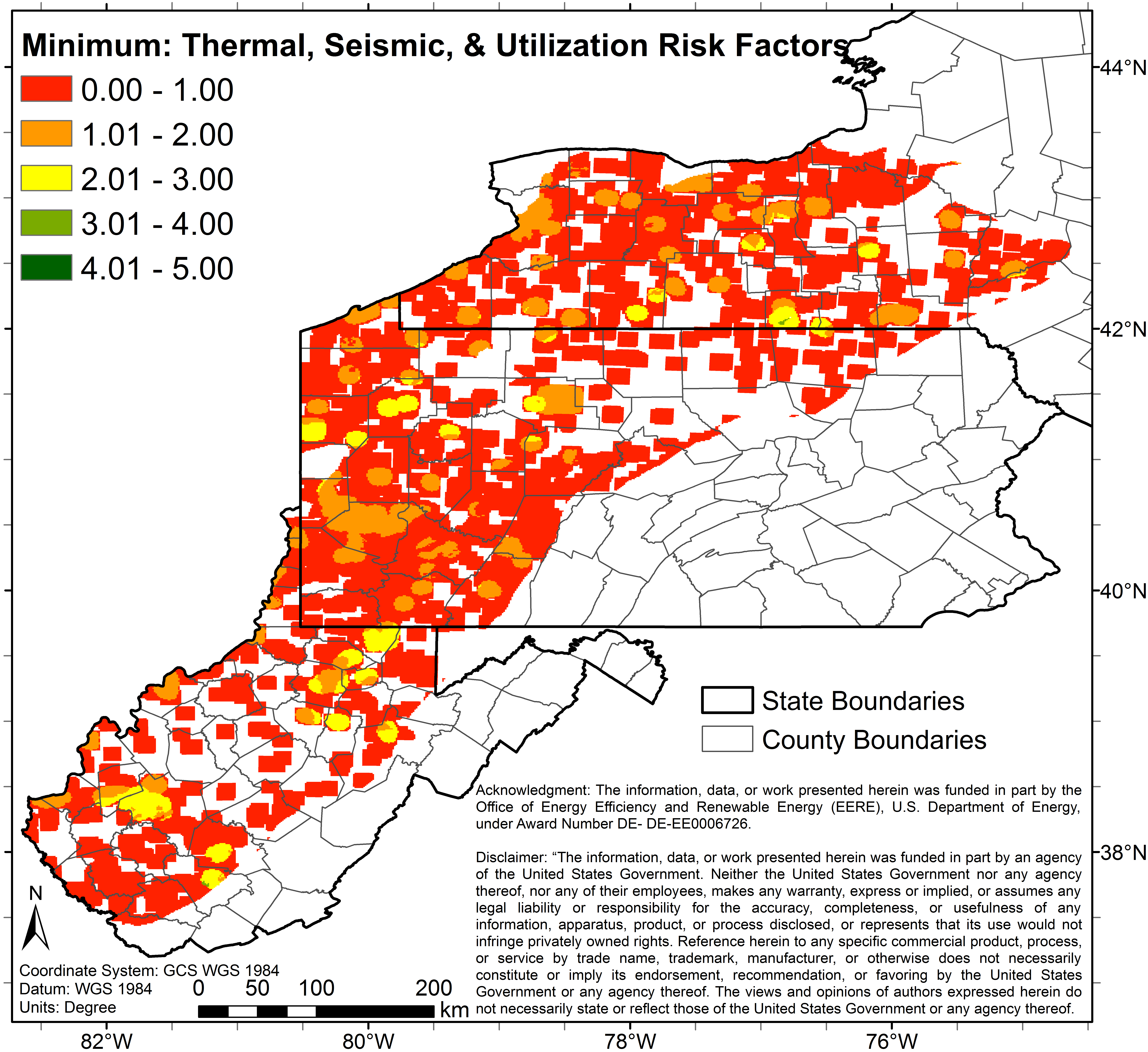
co_5_0_5_m.pngPNG
5 color map (Image File) of study area depicting predicted combined risks...
-
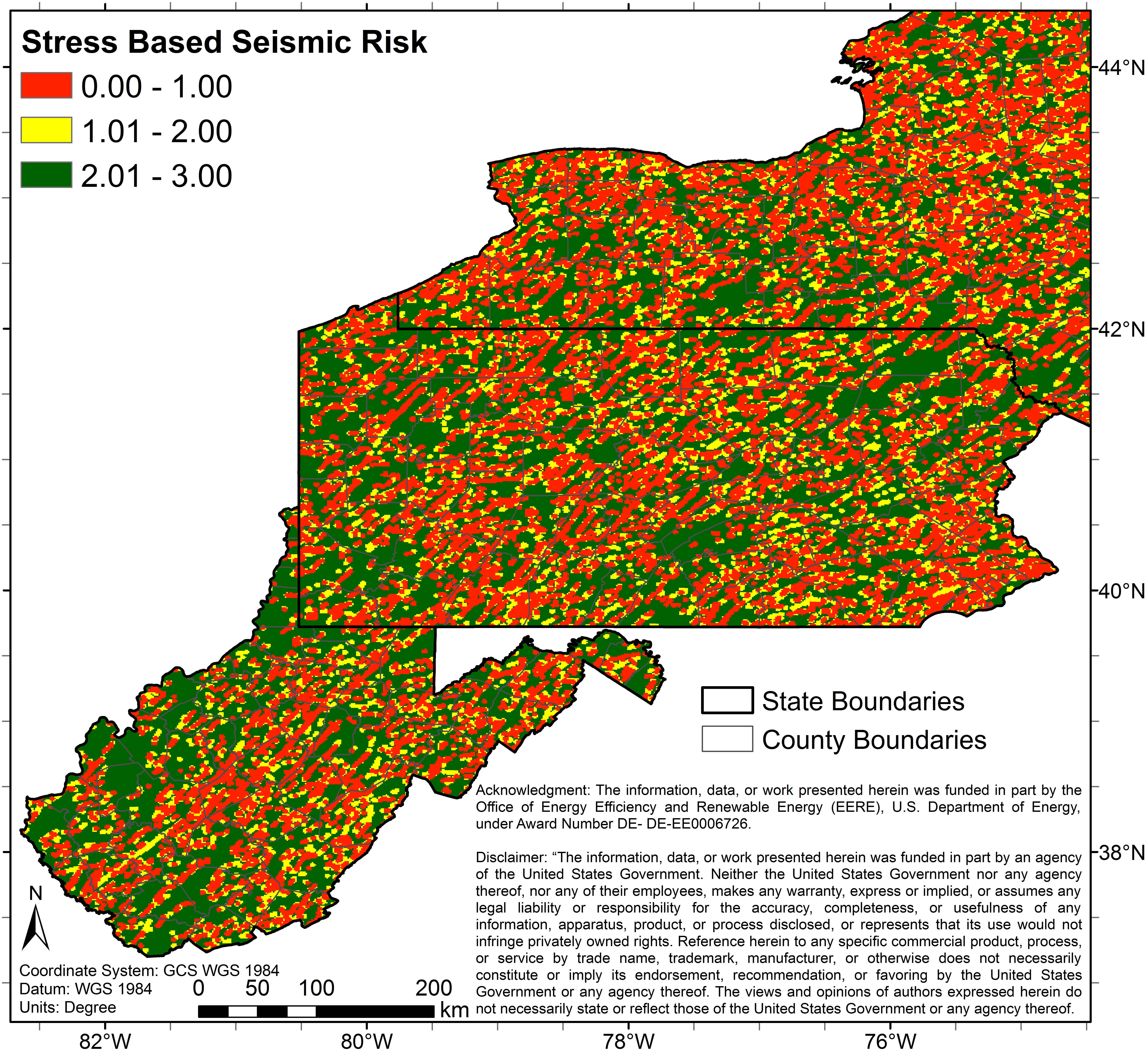
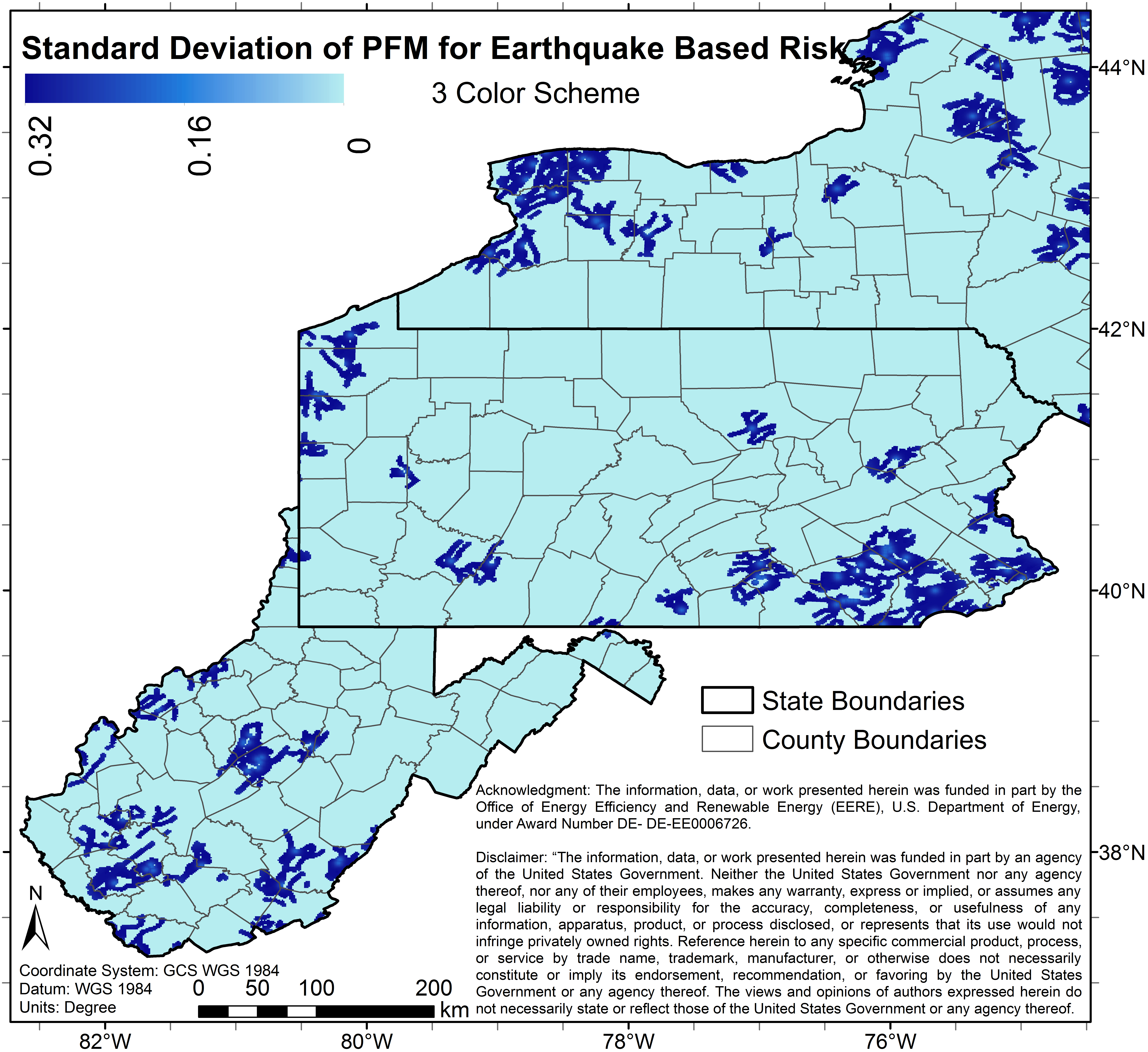
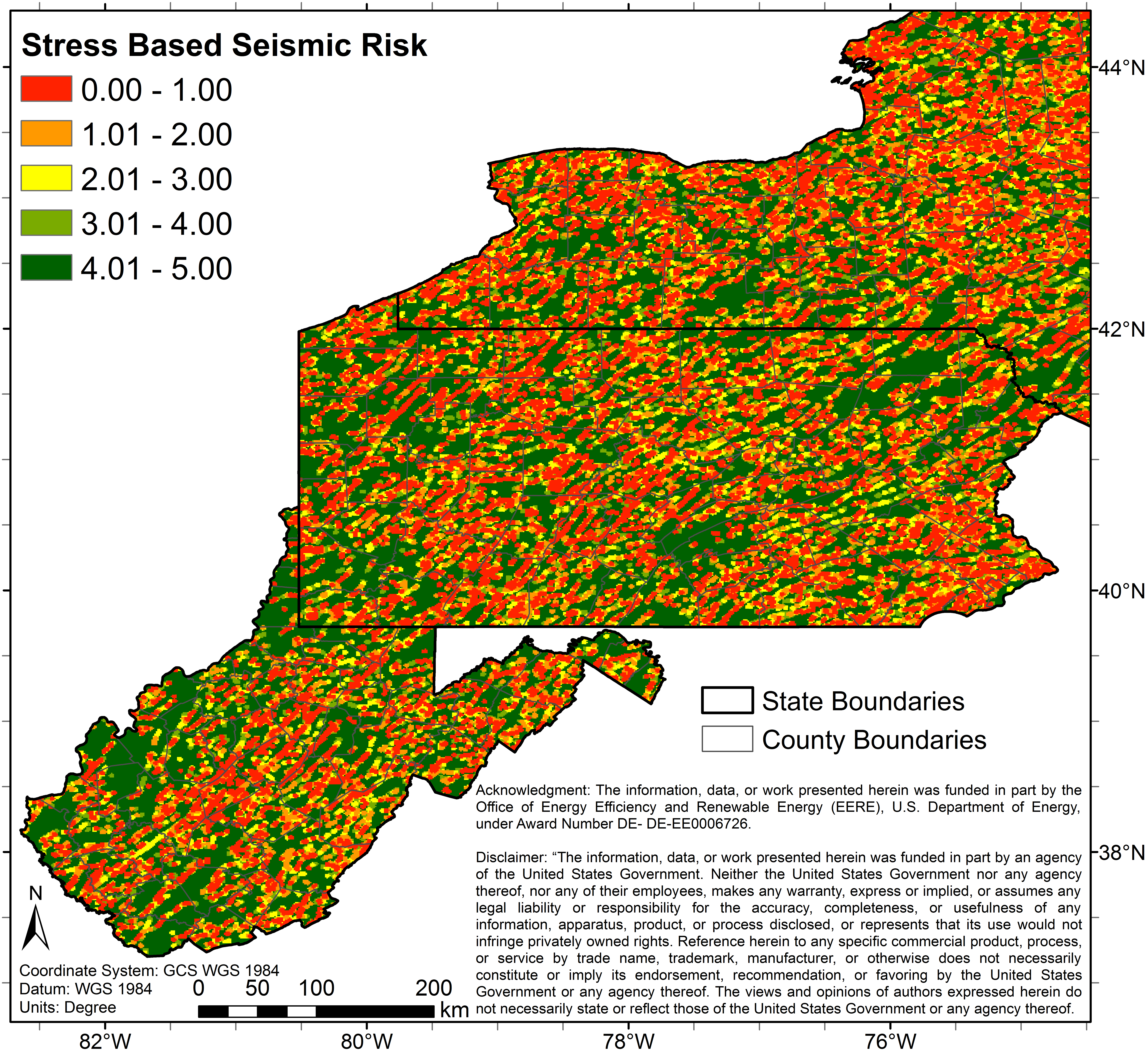
sest_3_0_3.pngPNG
3 color map (Image File) of study area depicting predicted seismic (stress...
-
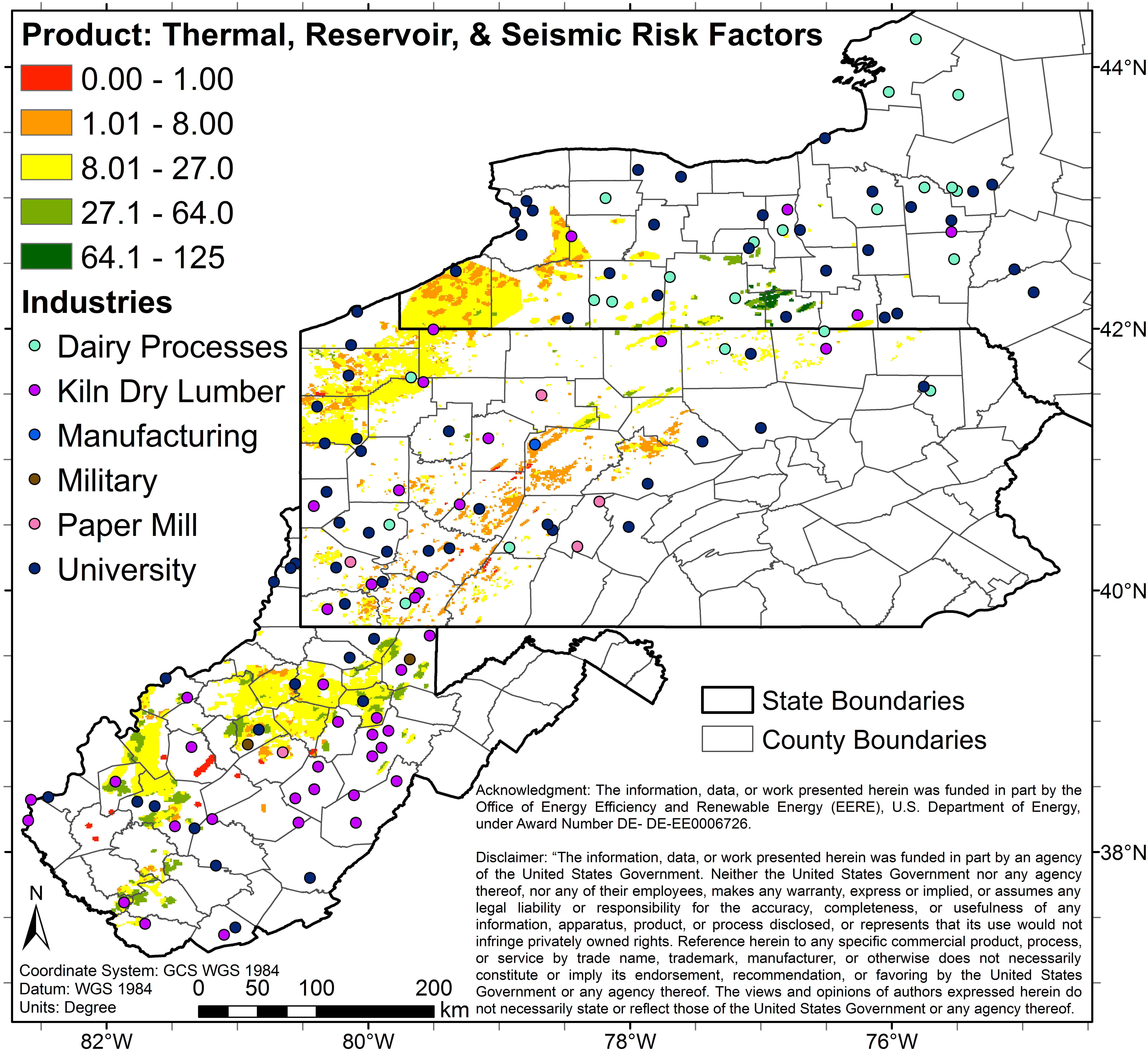
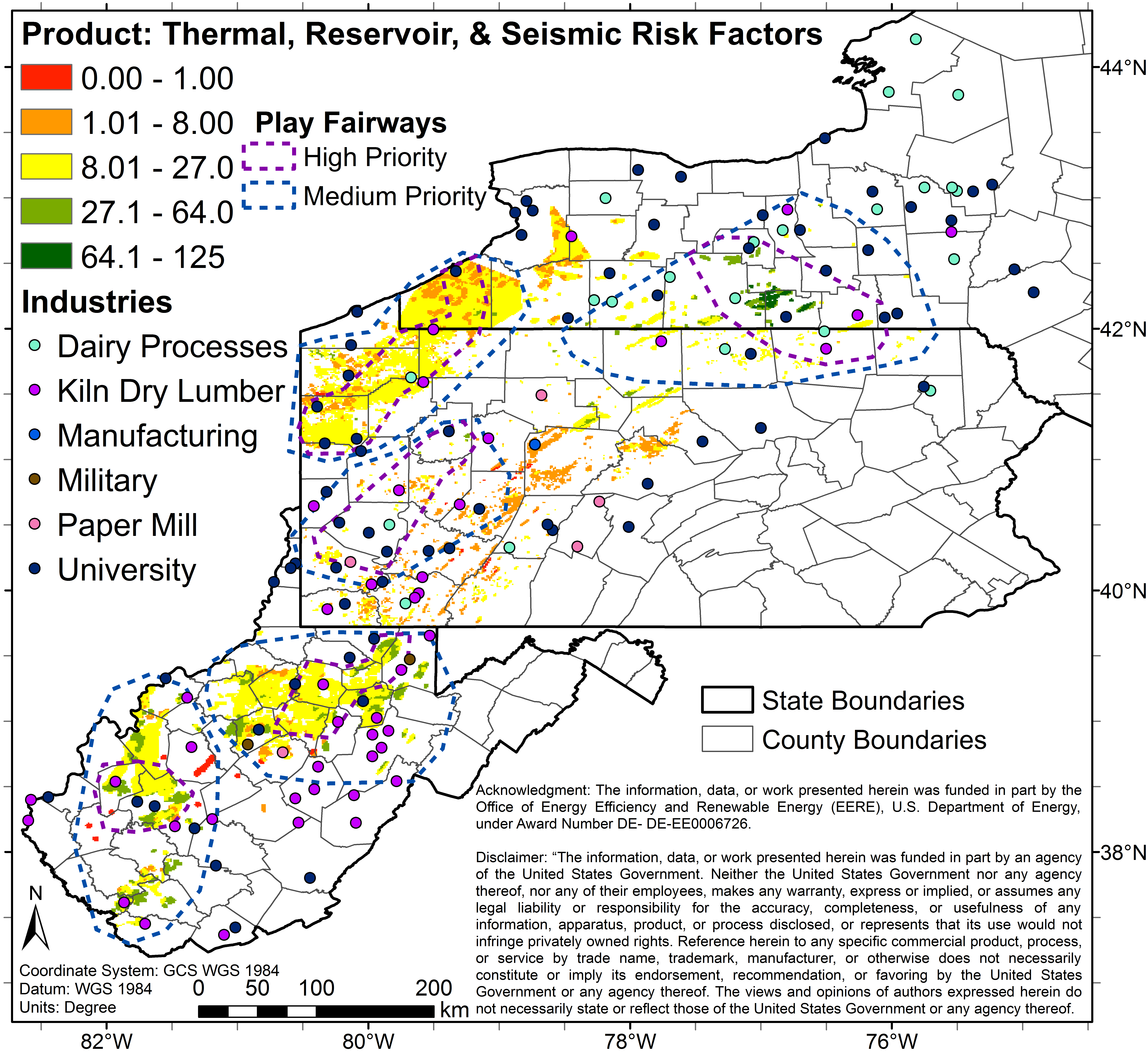
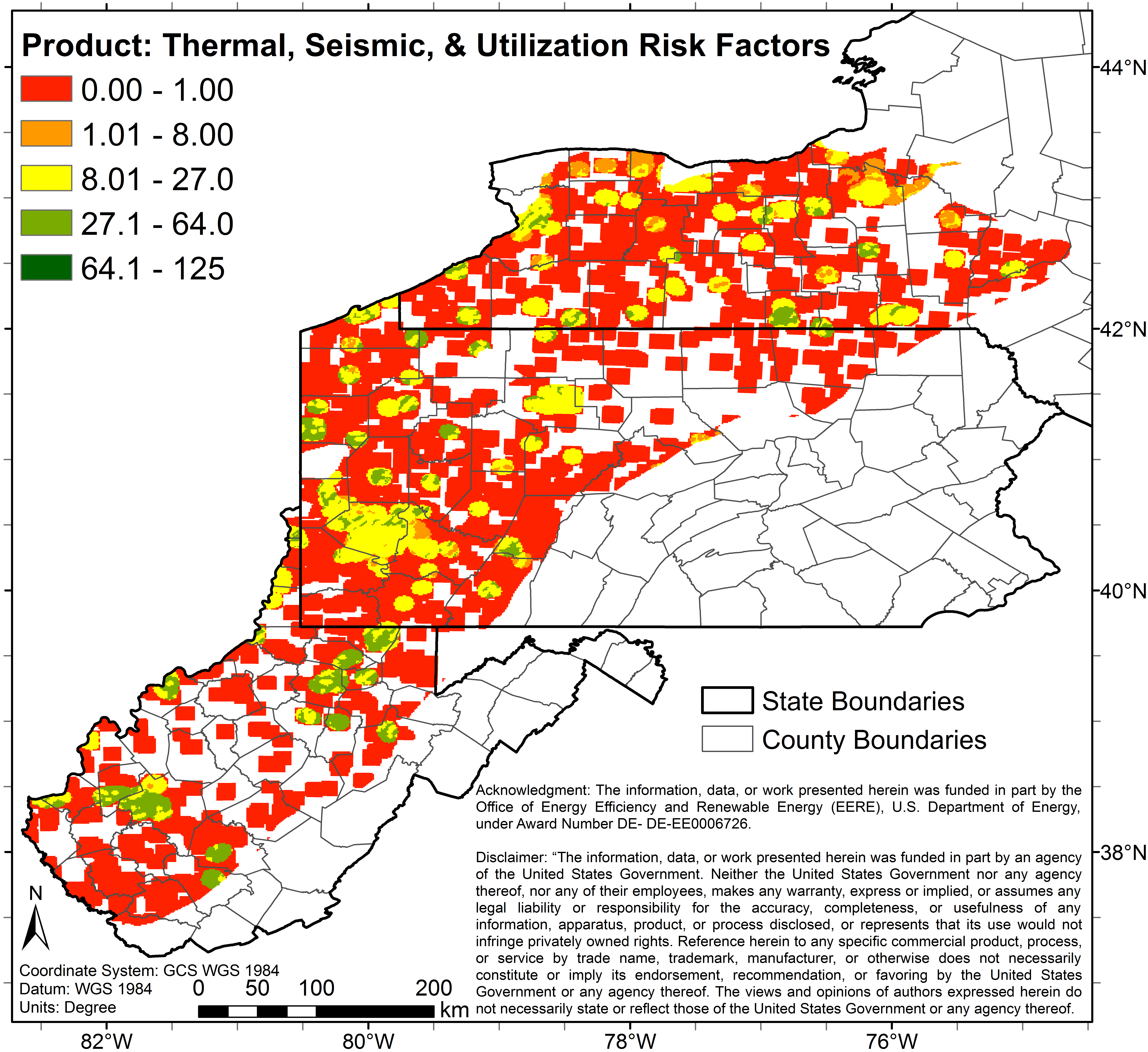
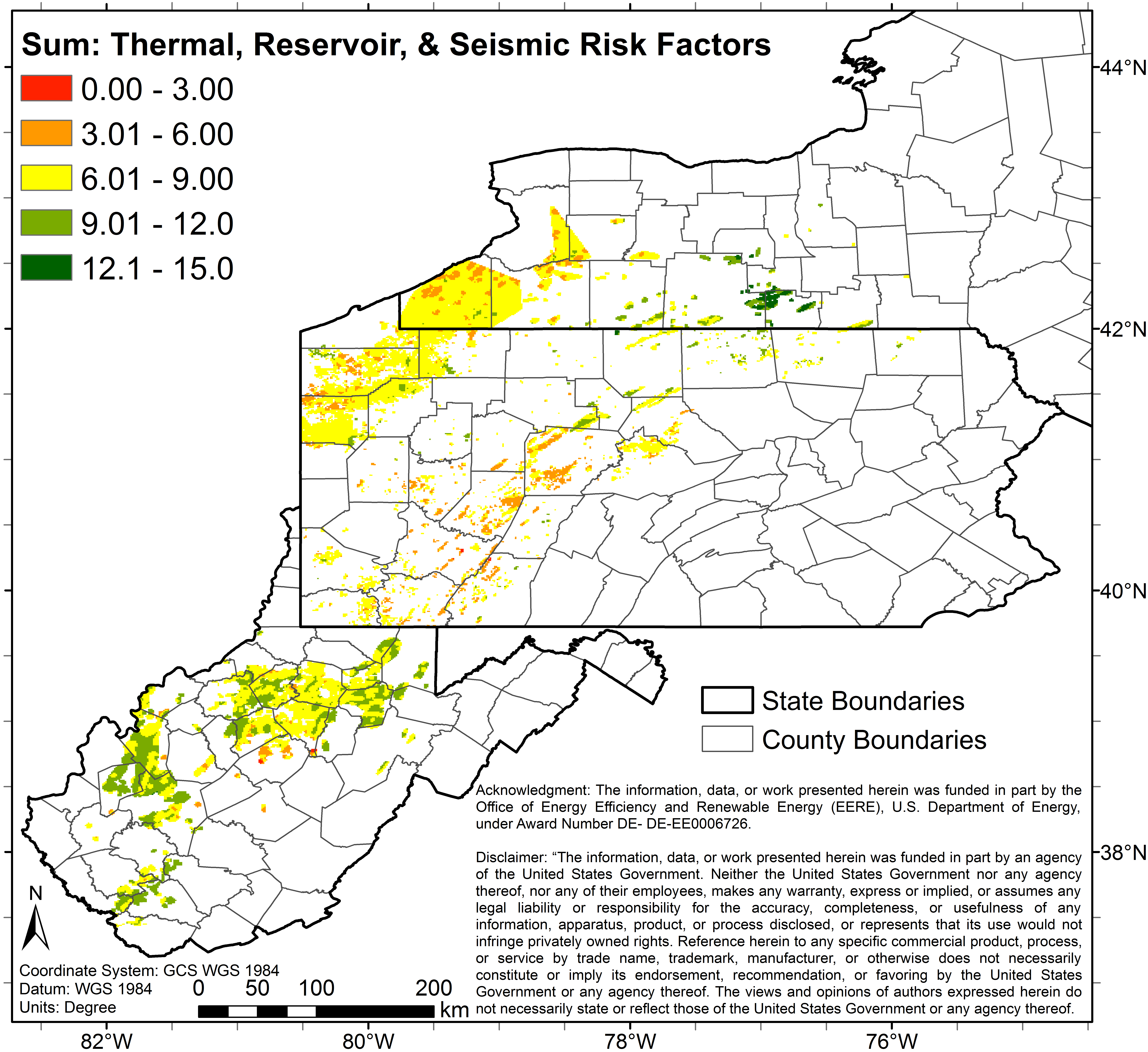
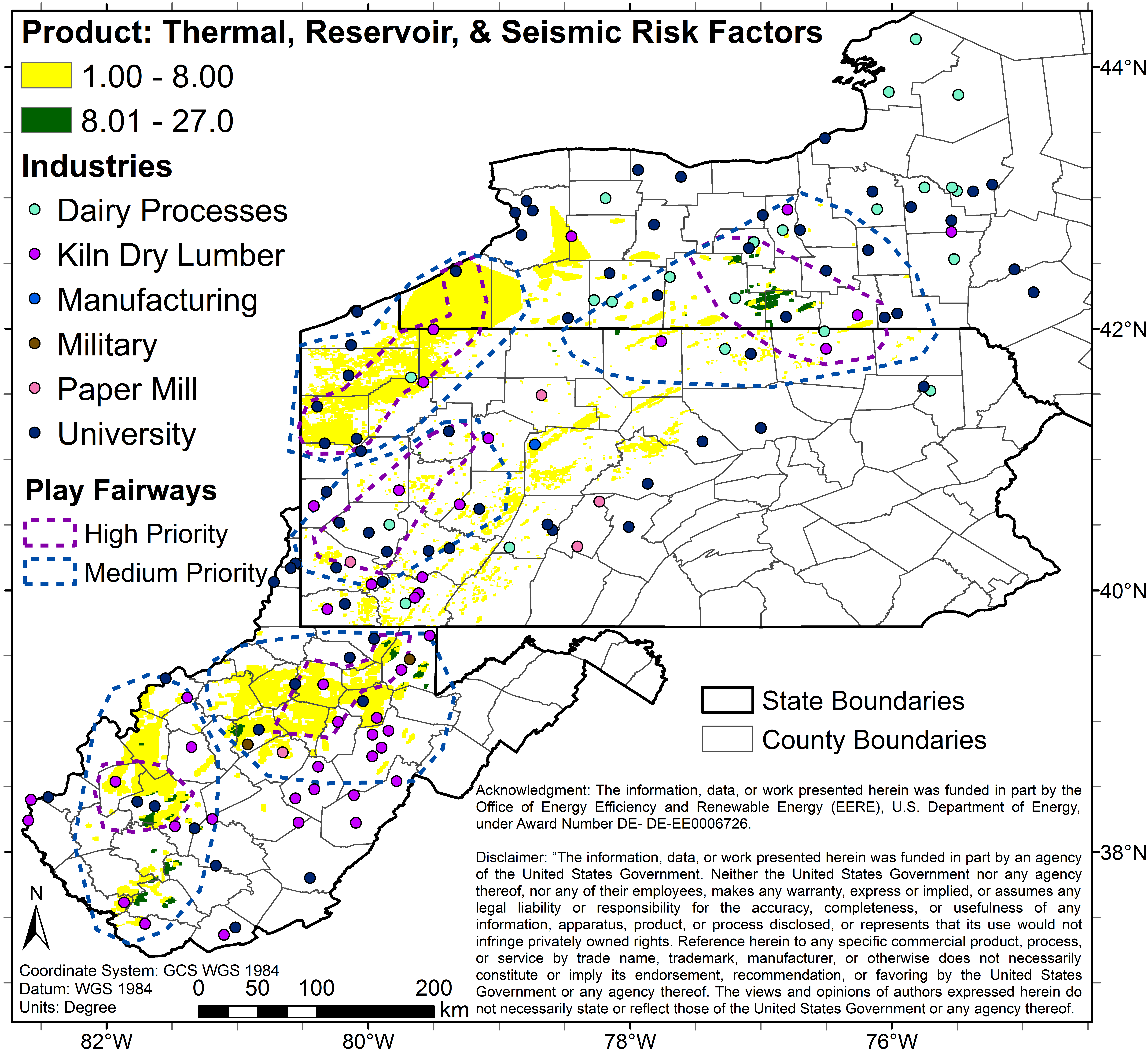
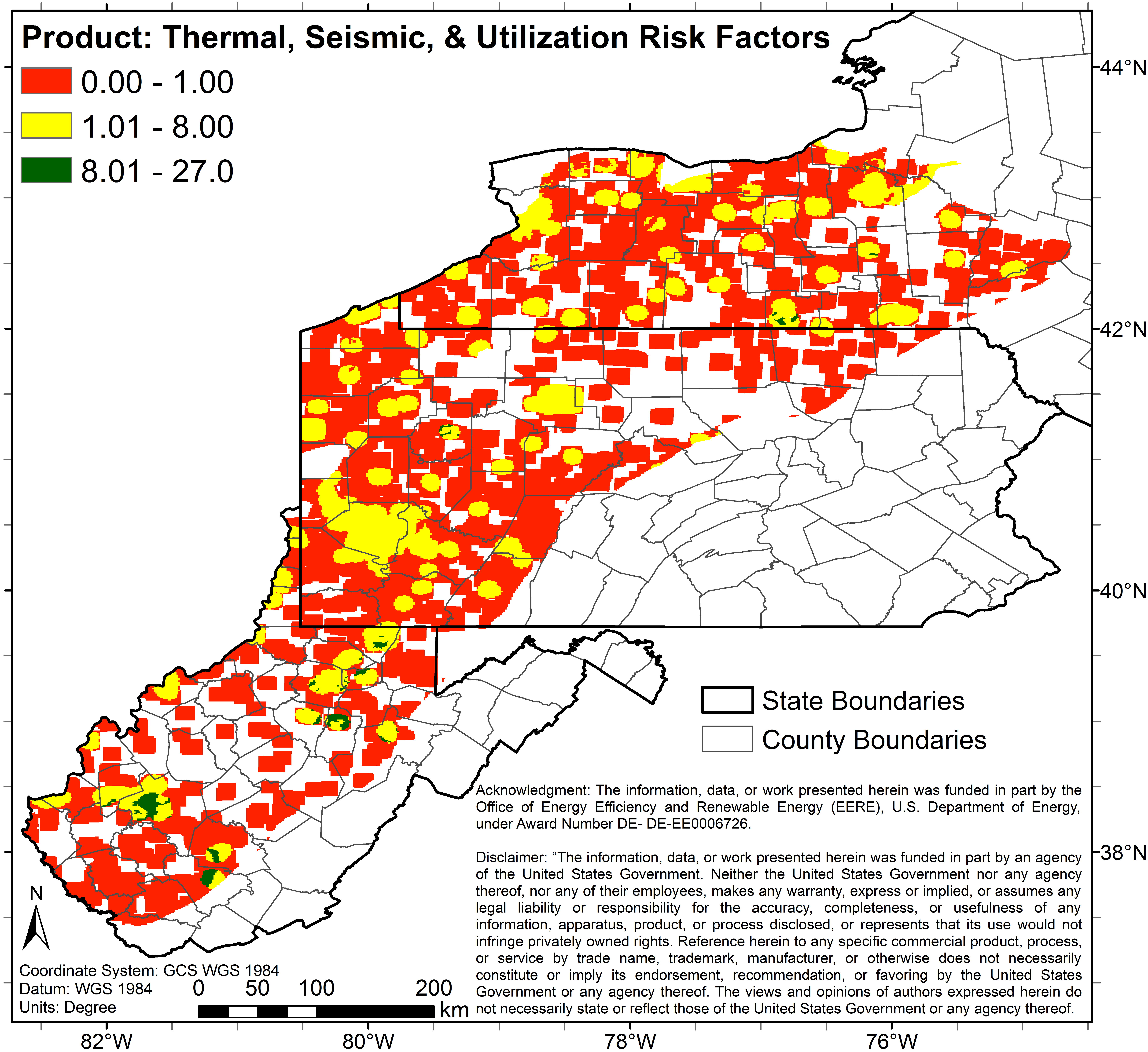
co_5_0_125_p_geo_industries.pngPNG
5 color map (Image File) of study area depicting predicted combined risks...
-
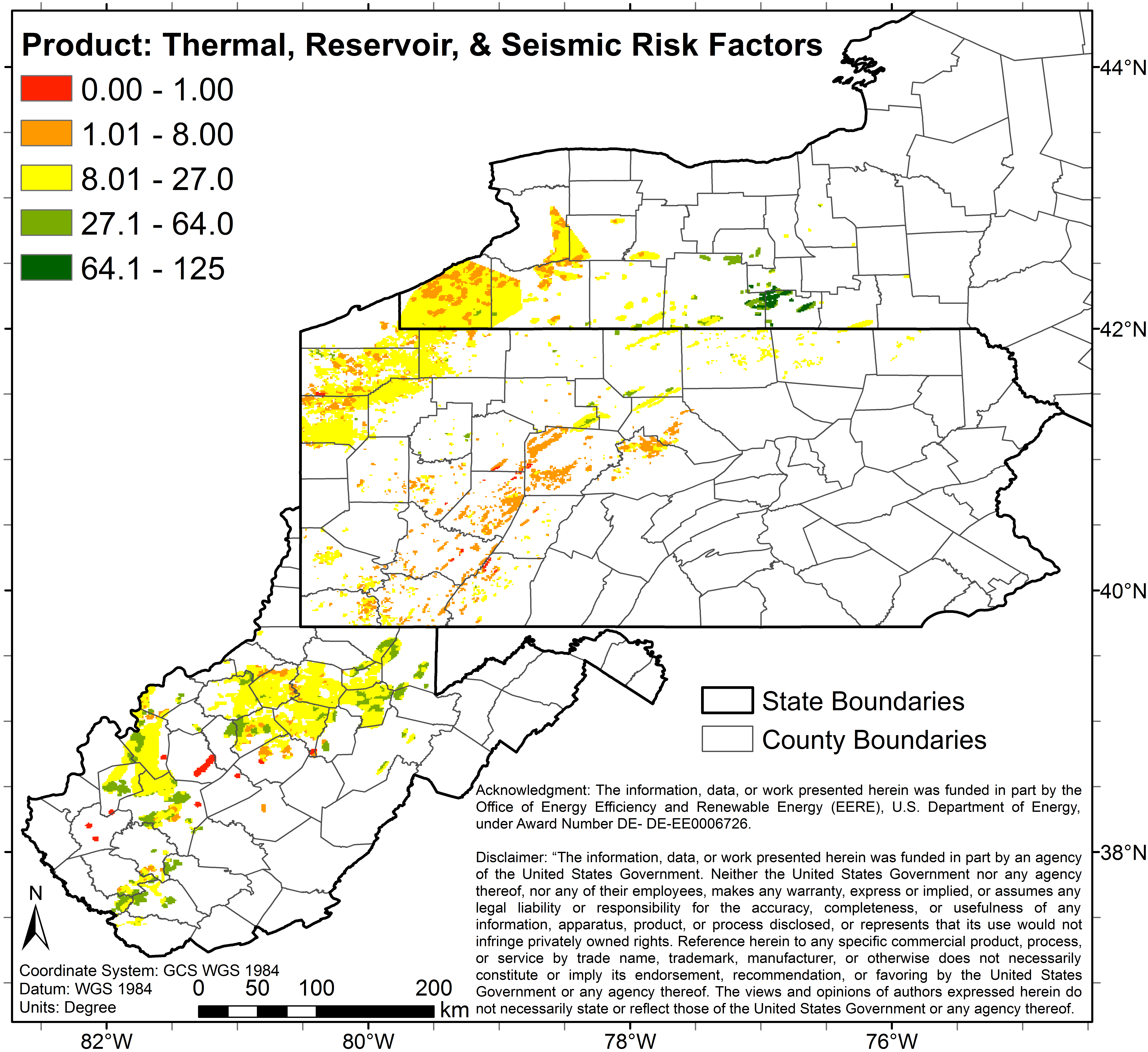
co_5_0_125_p_geo.pngPNG
5 color map (Image File) of study area depicting predicted combined risks...
-
co_3_0_9_s_egs.pngPNG
3 color map (Image File) of study area depicting predicted combined risks...
-
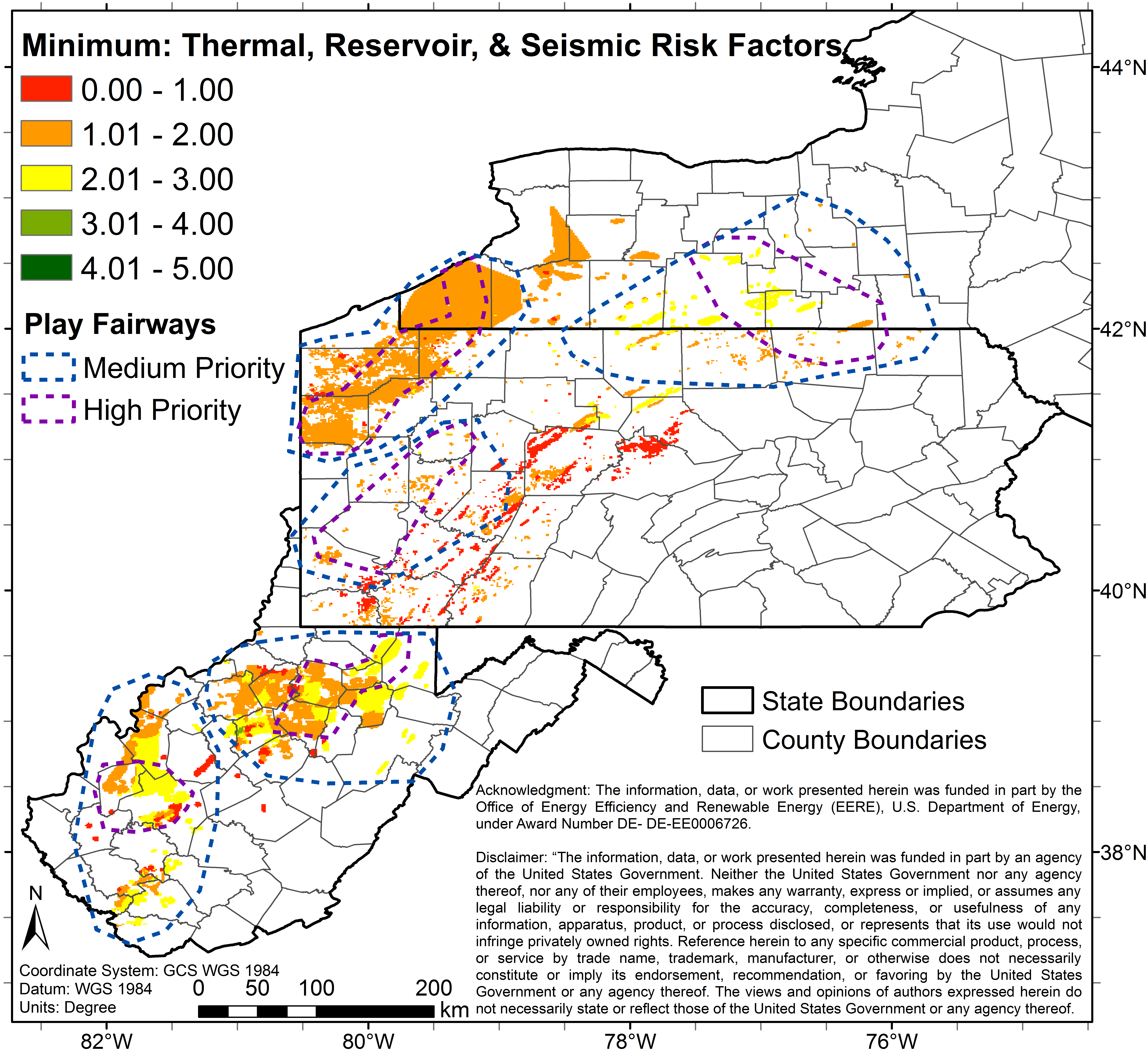
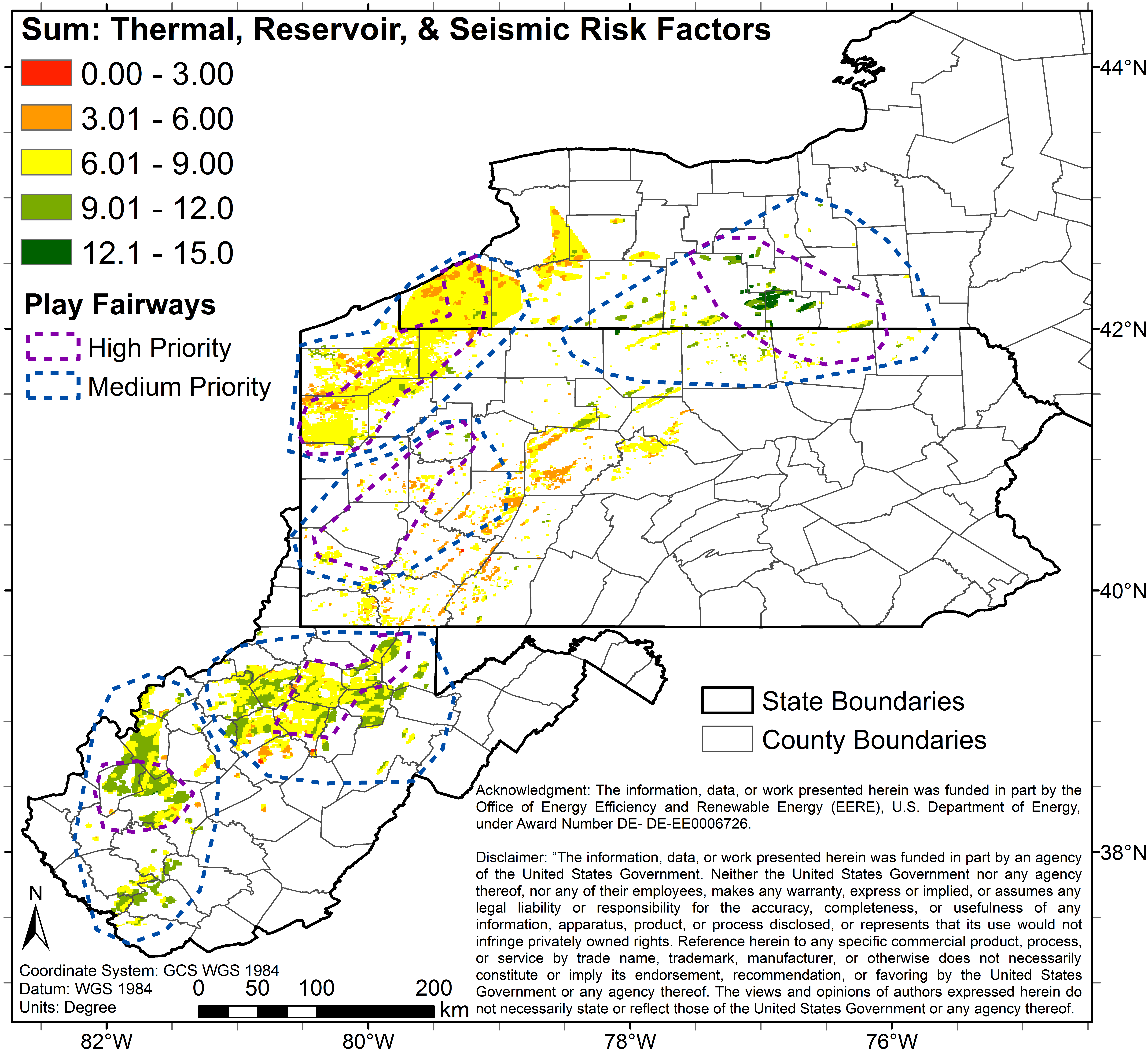
co_5_0_125_p_geo_industries_fairways.pngPNG
5 color map (Image File) of study area depicting predicted combined risks...
-
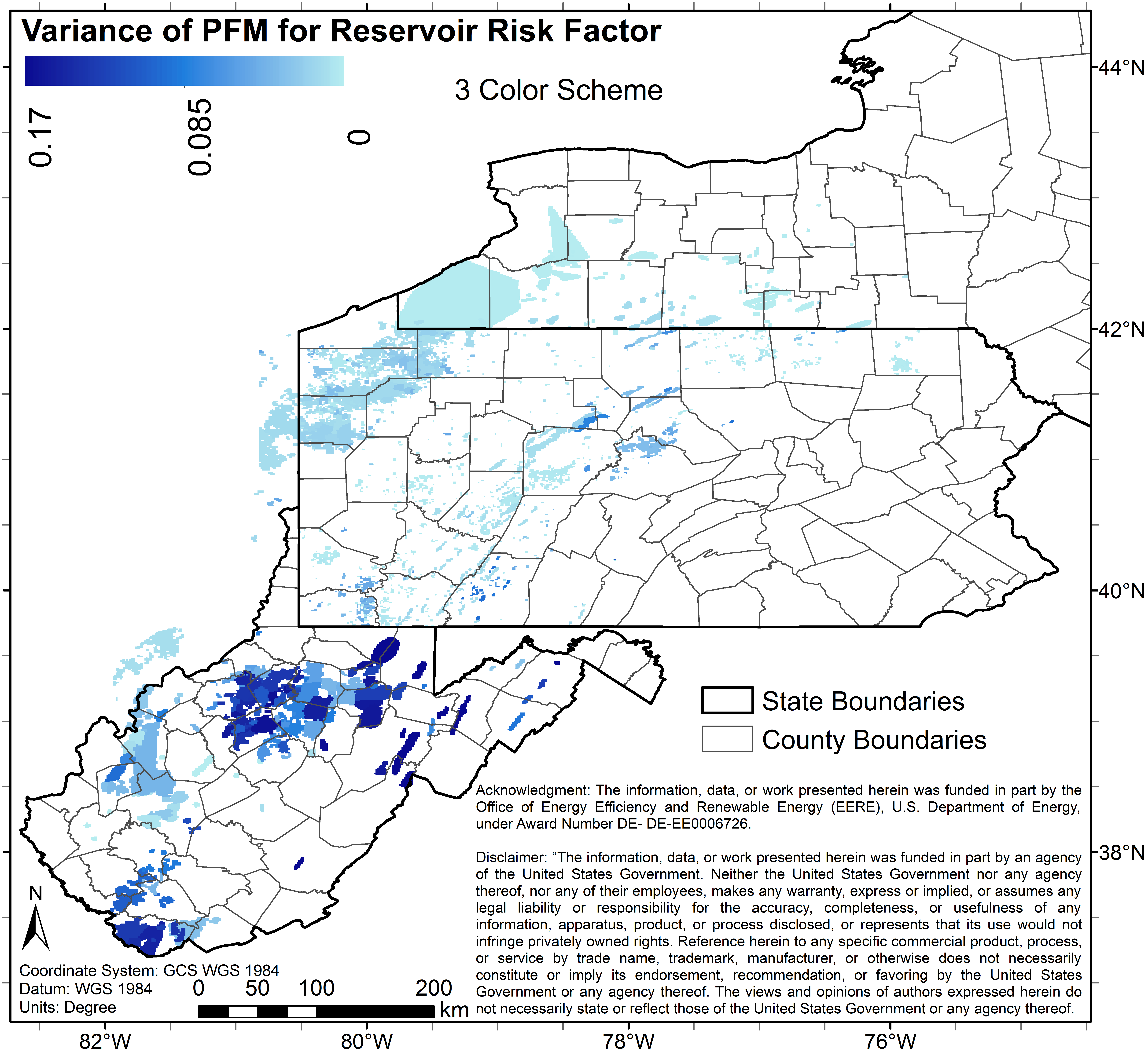
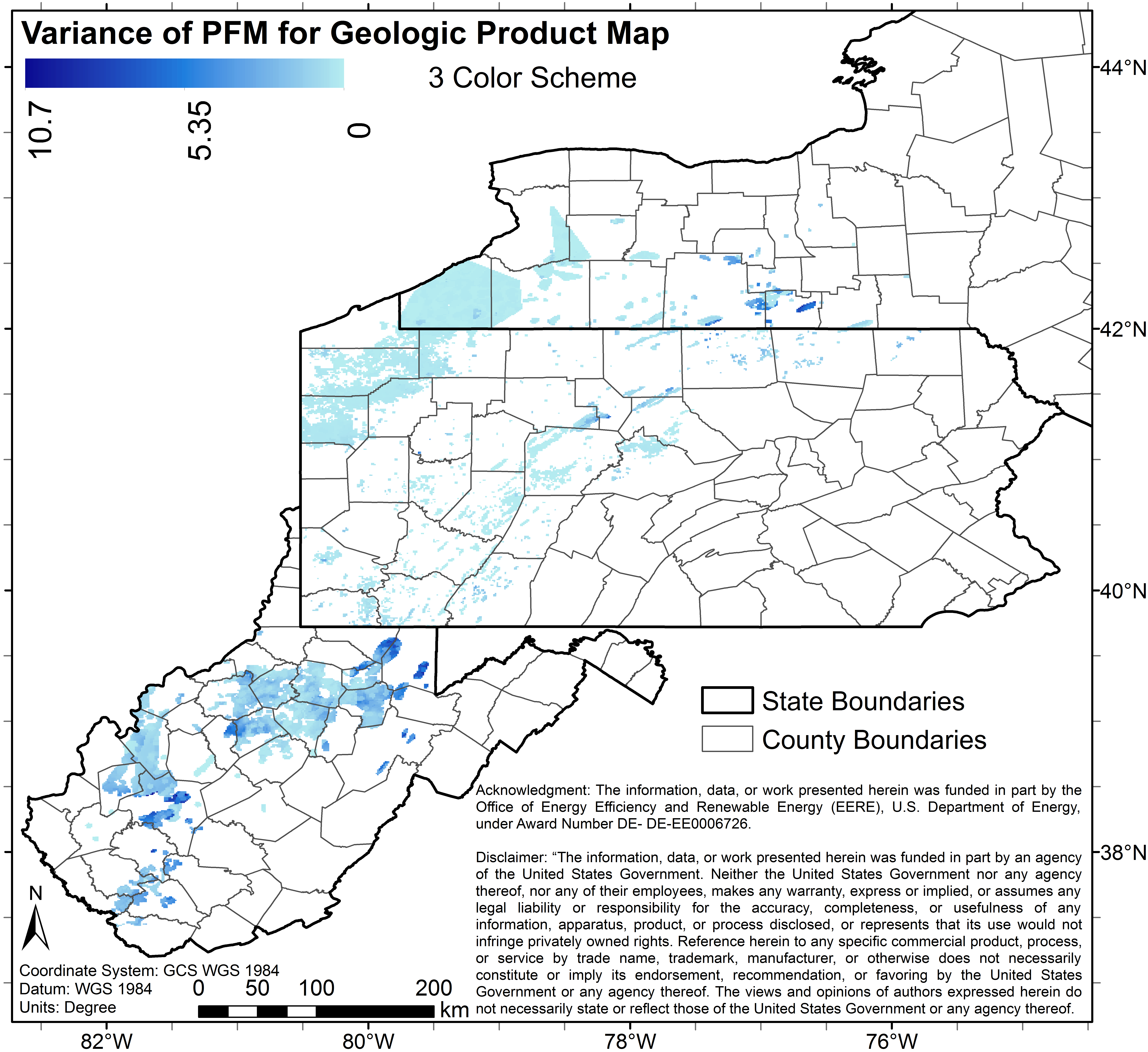
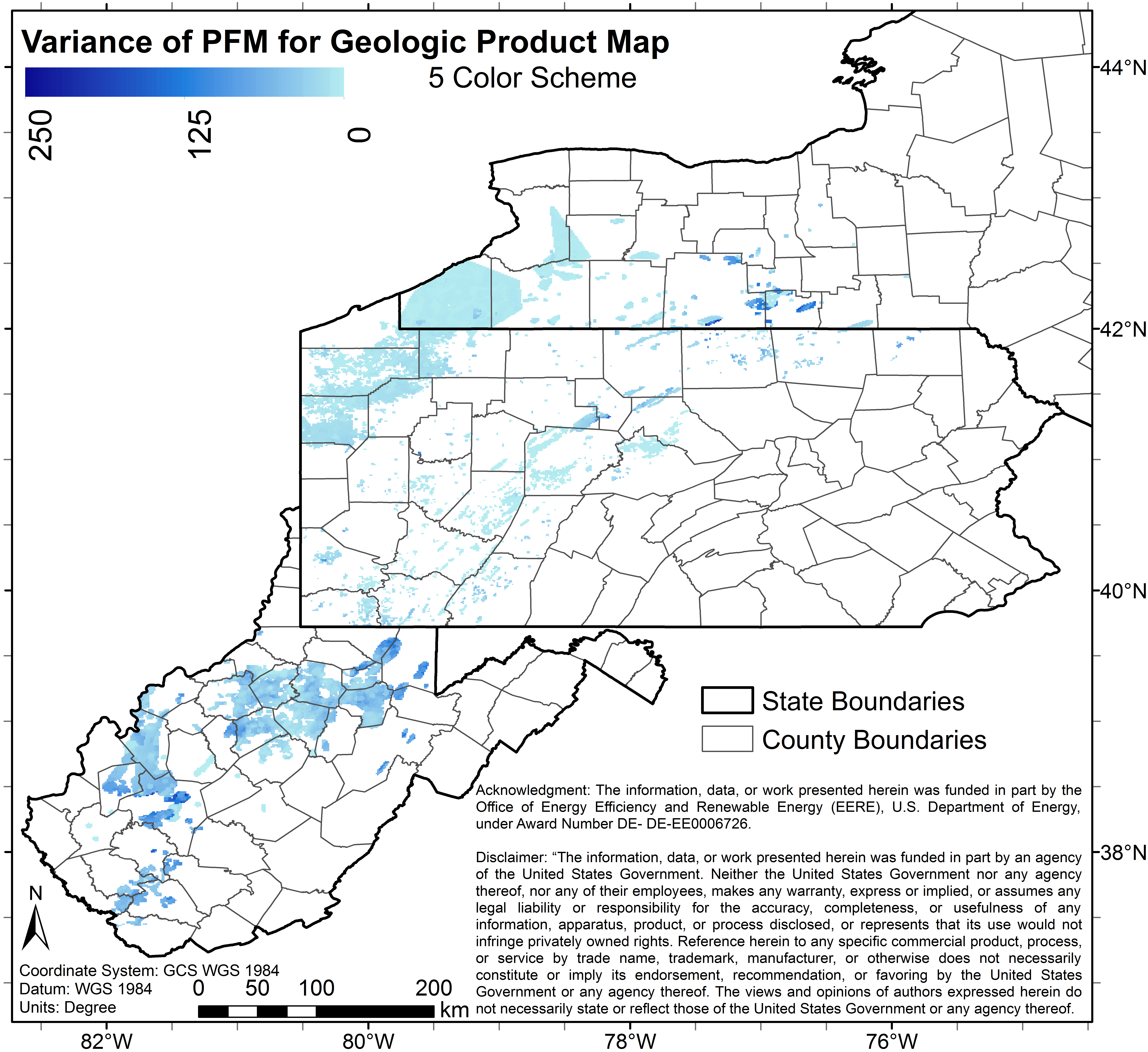
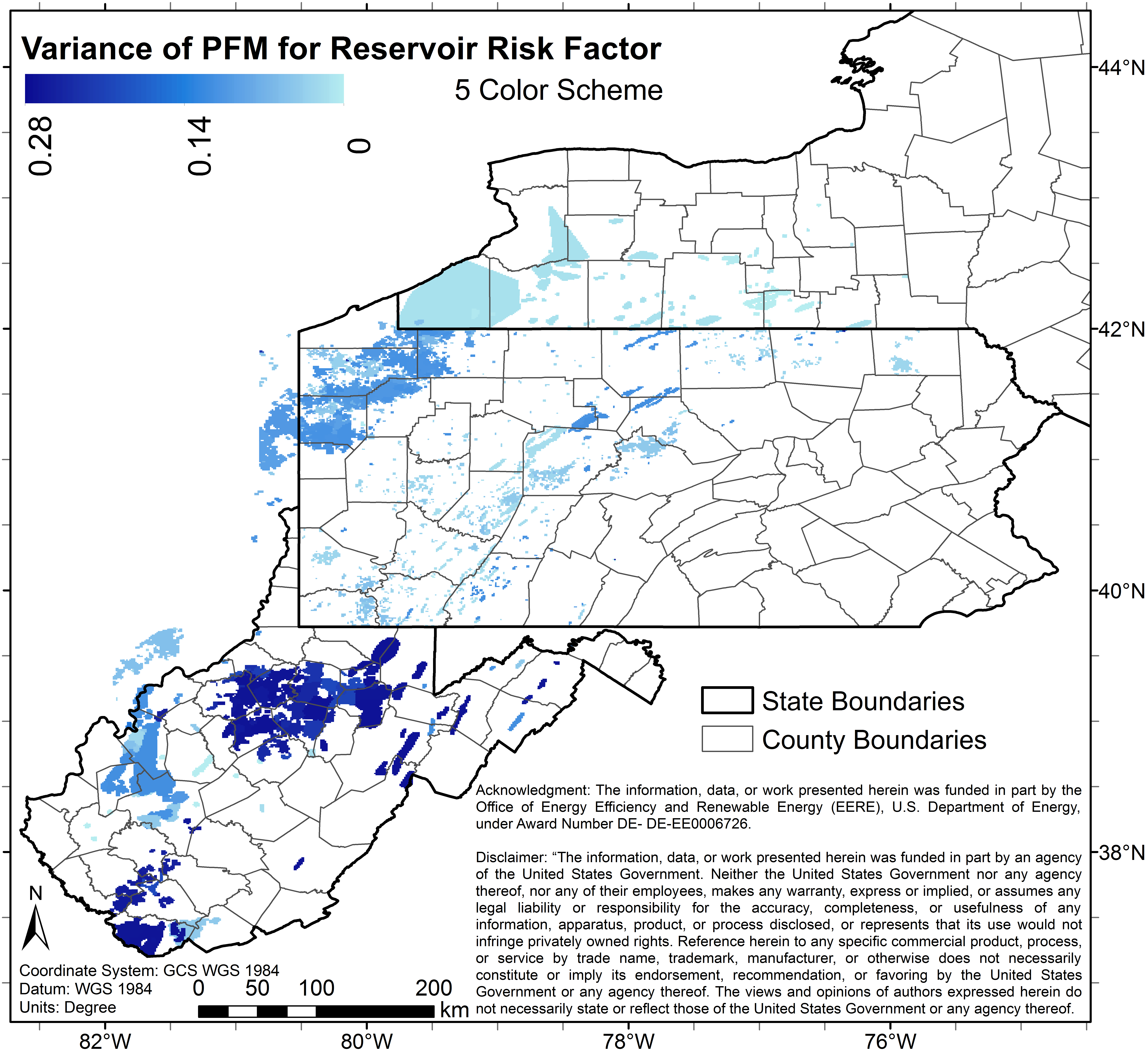
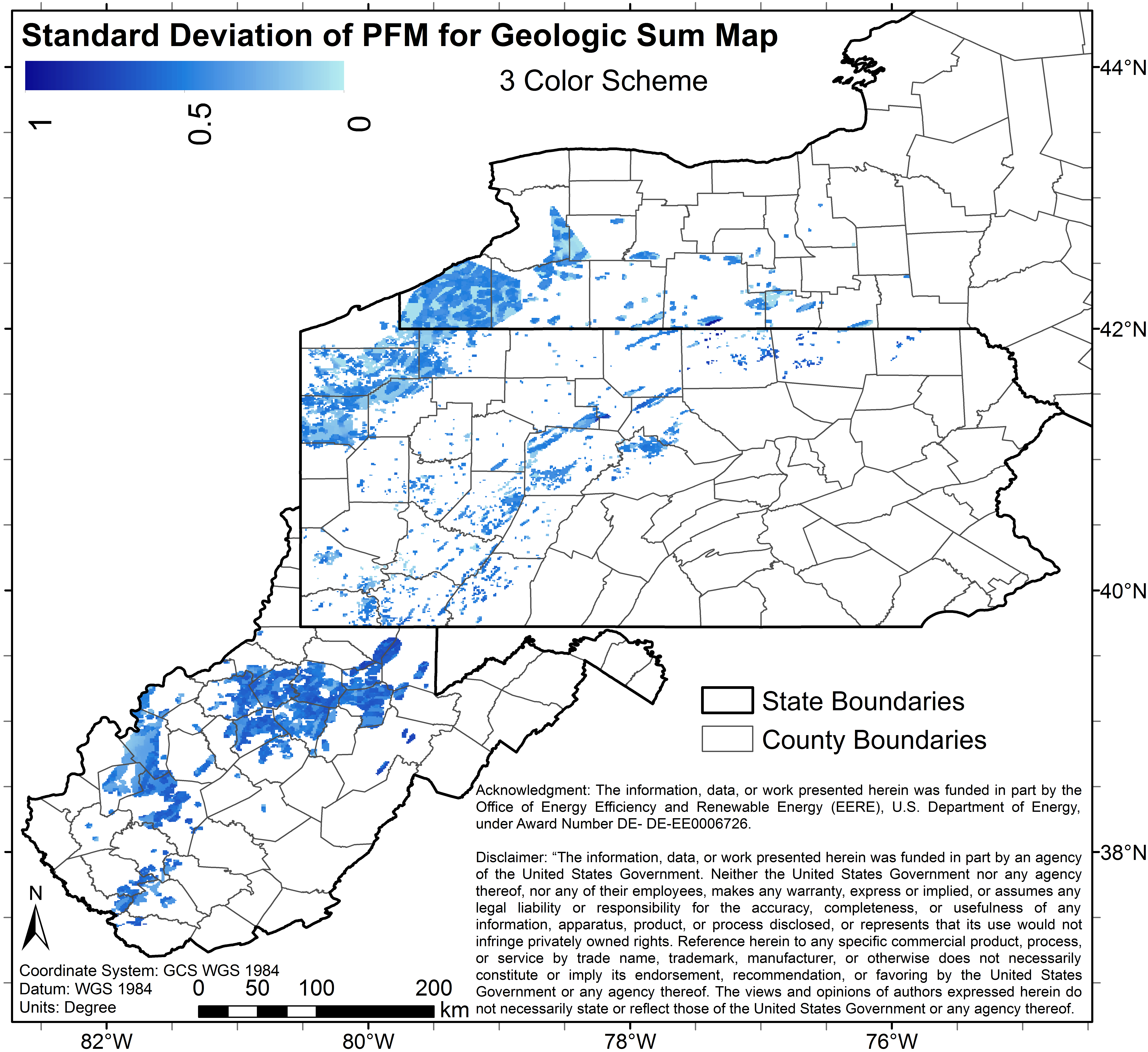
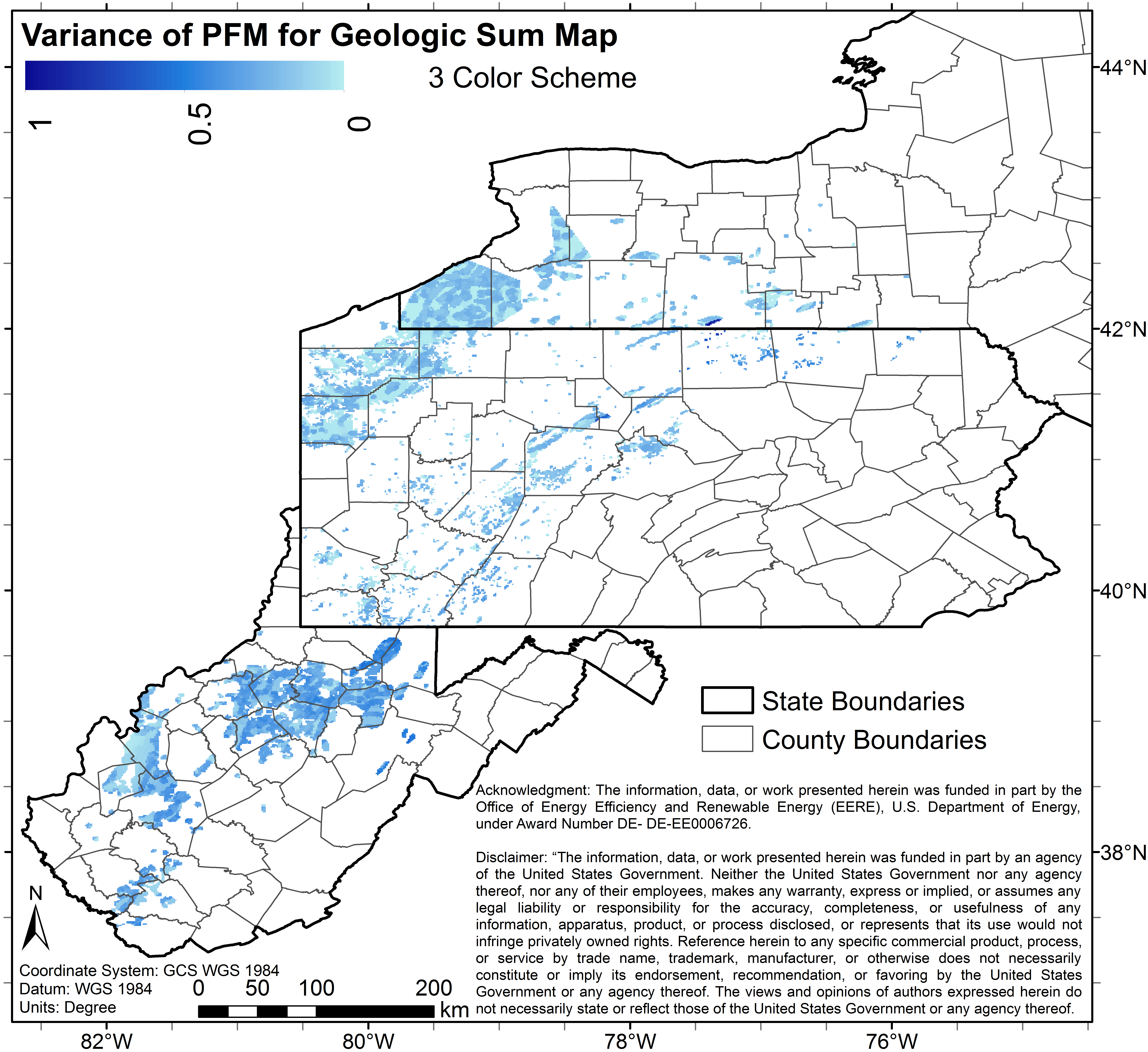
re_pfa_var3.pngPNG
Image File of the uncertainty (variance) associated with the 3 color map...
-
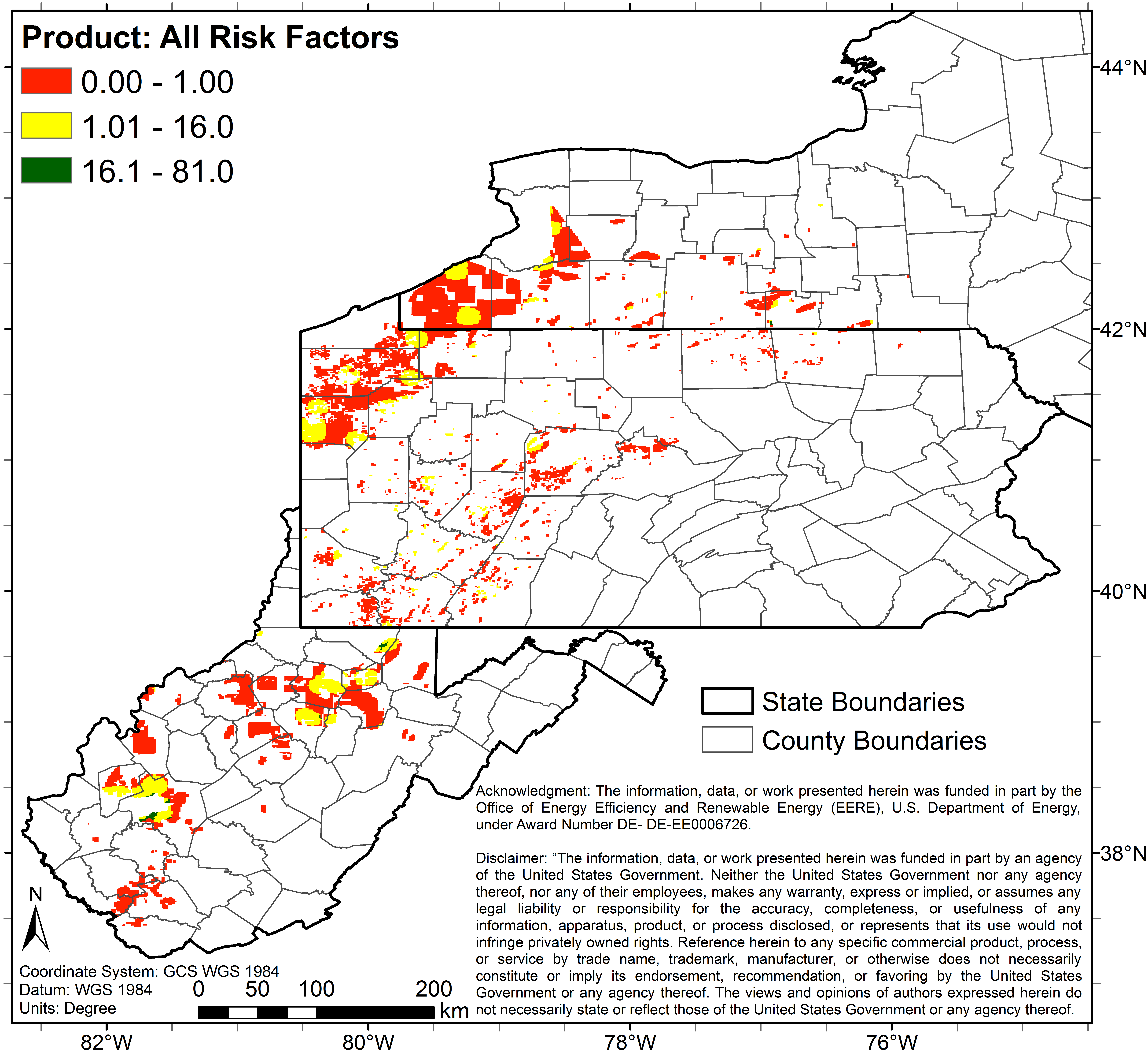
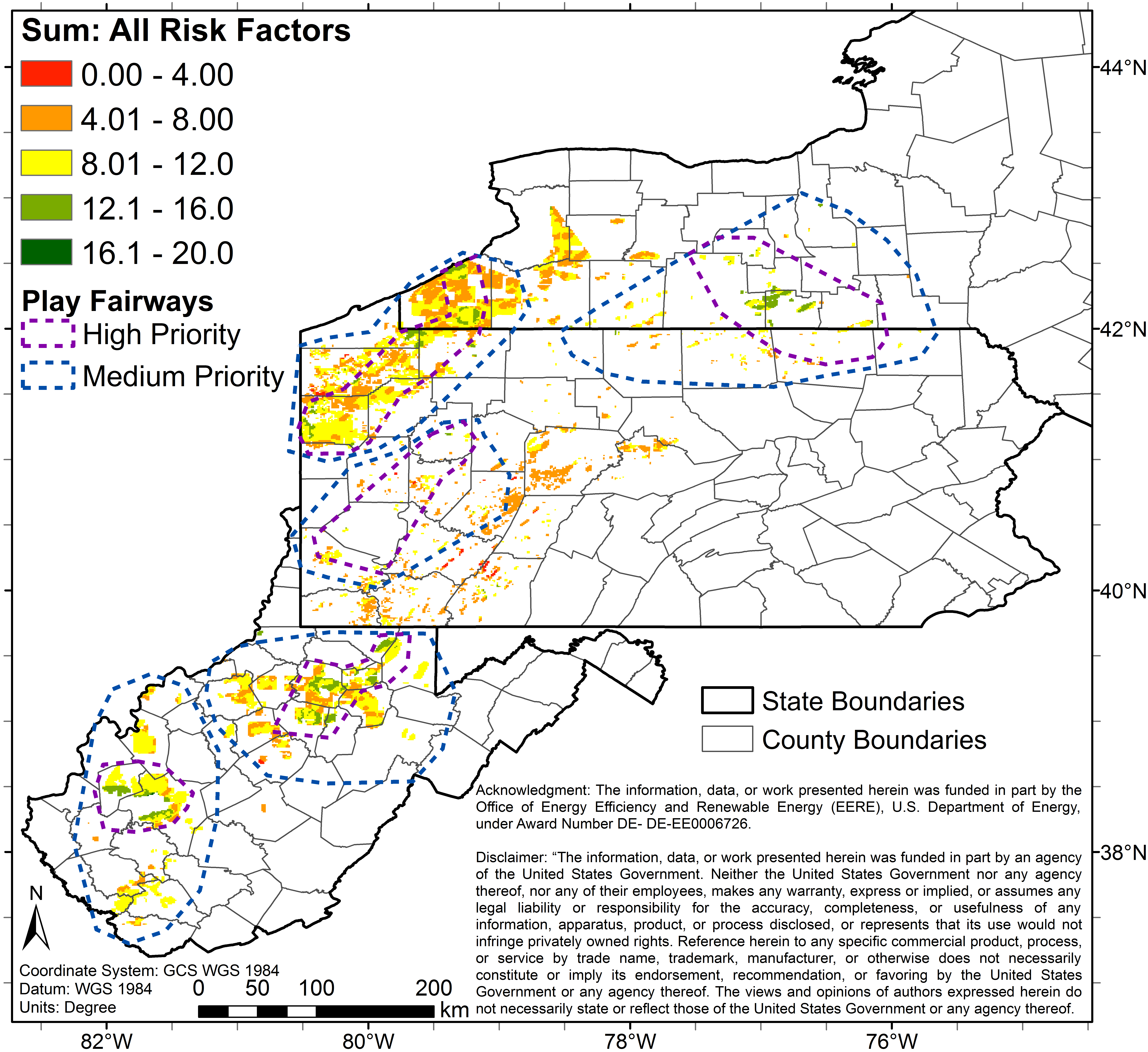
co_3_0_81_p.pngPNG
3 color map (Image File) of study area depicting predicted combined risks...
-
se_pfa_var5.pngPNG
Image File of the uncertainty (variance) associated with 5 color map (Image...
-
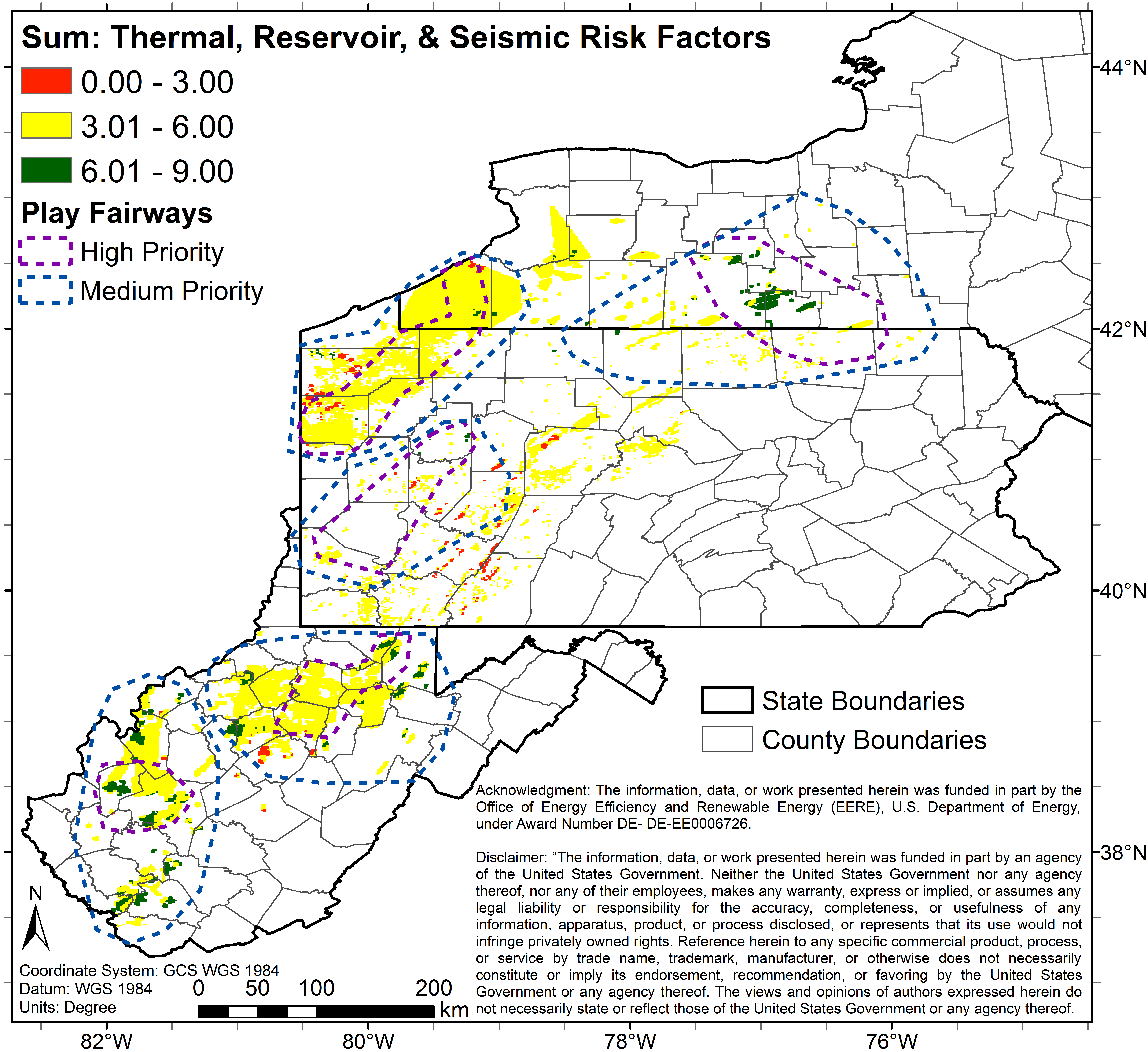
co_3_0_9_s_geo_industries_fairways.pngPNG
3 color map (Image File) of study area depicting predicted combined risks...
-
co_3_0_3_m.pngPNG
3 color map (Image File) of study area depicting predicted combined risks...
-
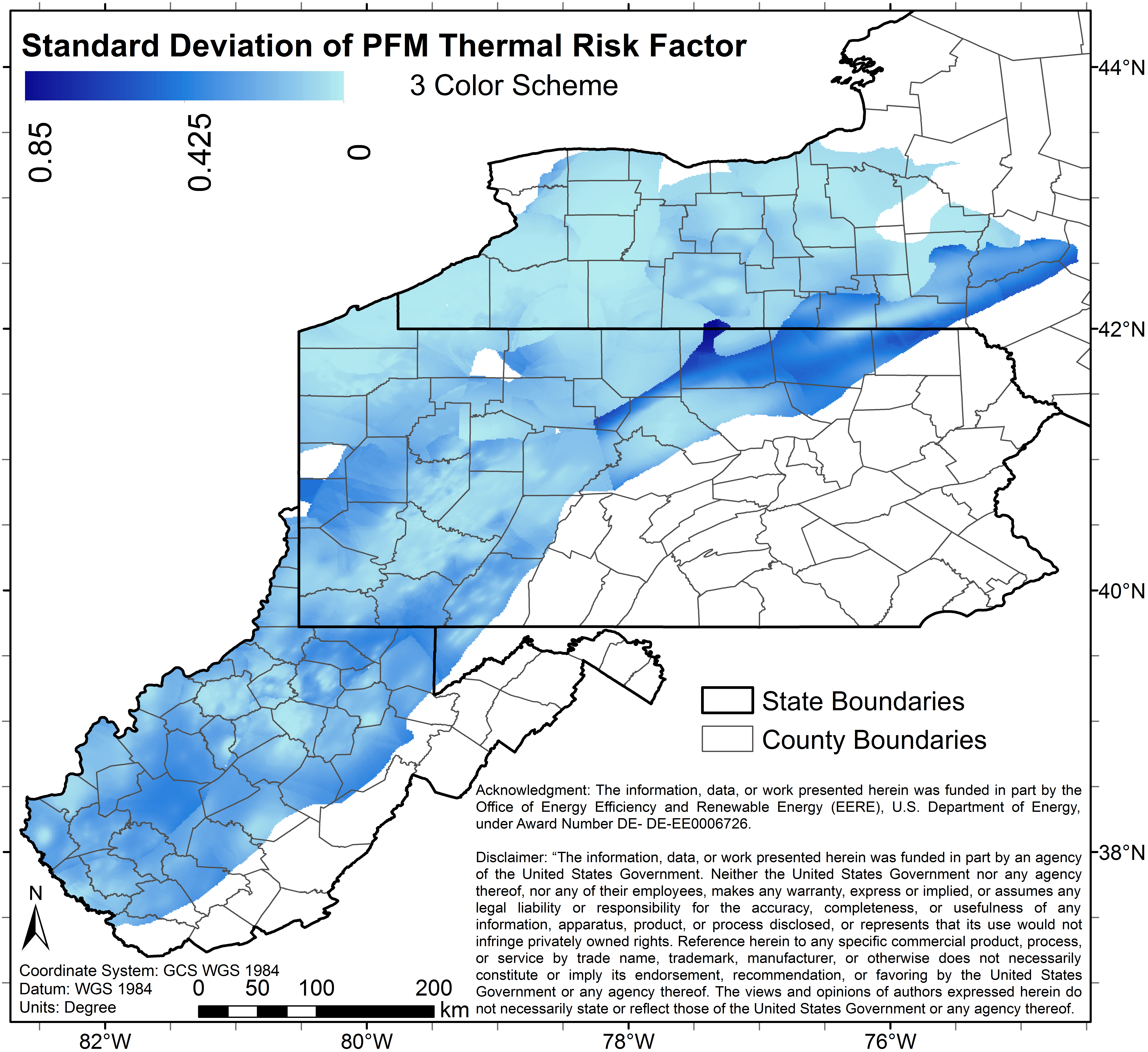
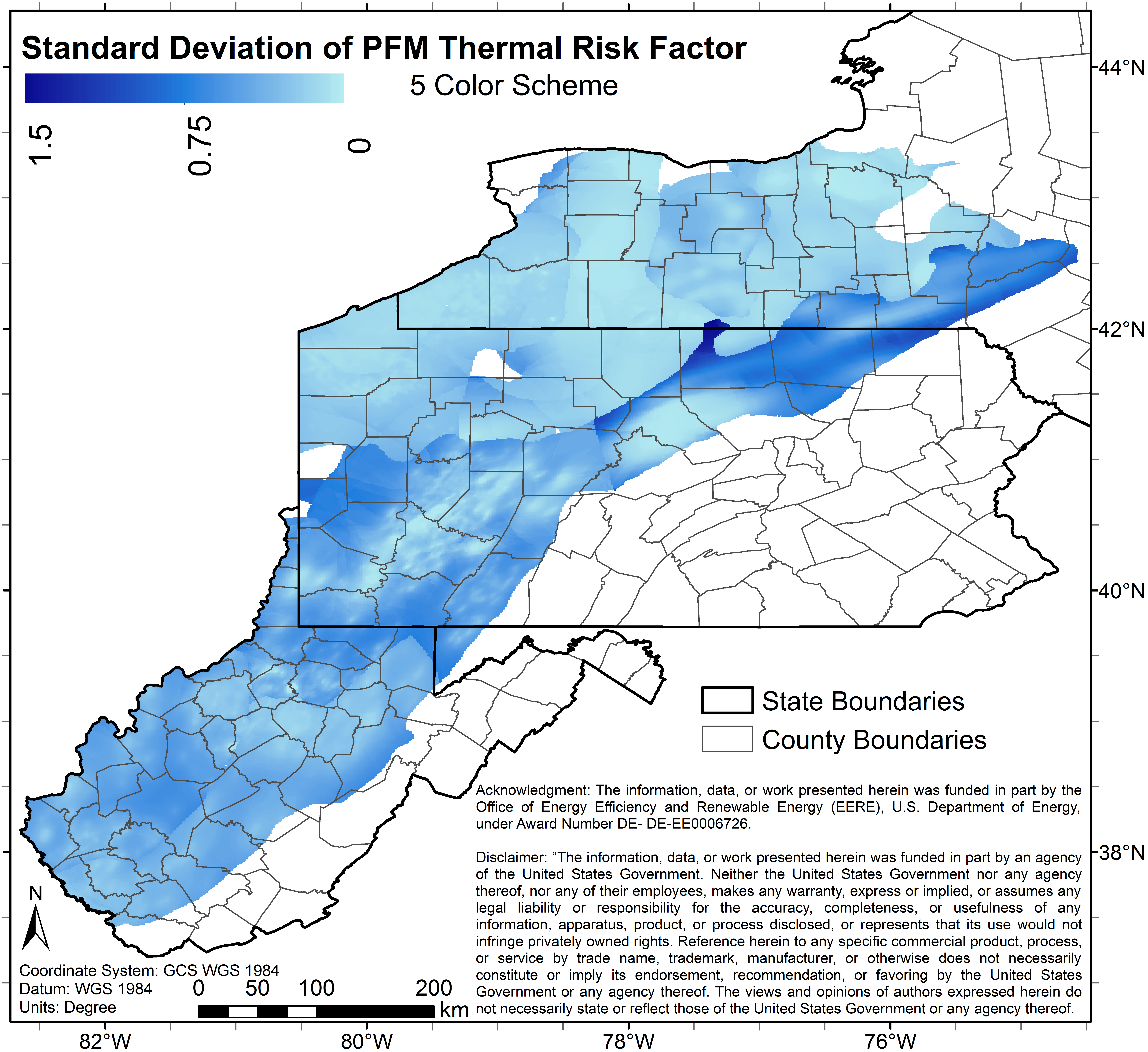
th_pfa_sd3.pngPNG
Image File of the uncertainty (standard deviation) associated with the 3...
-
seeq_sd3.pngPNG
Image File of the uncertainty (standard deviation) associated with the 3...
-
co_pfa_sd5_s_geo.pngPNG
Image File of the uncertainty (standard deviation) associated with the 5...
-
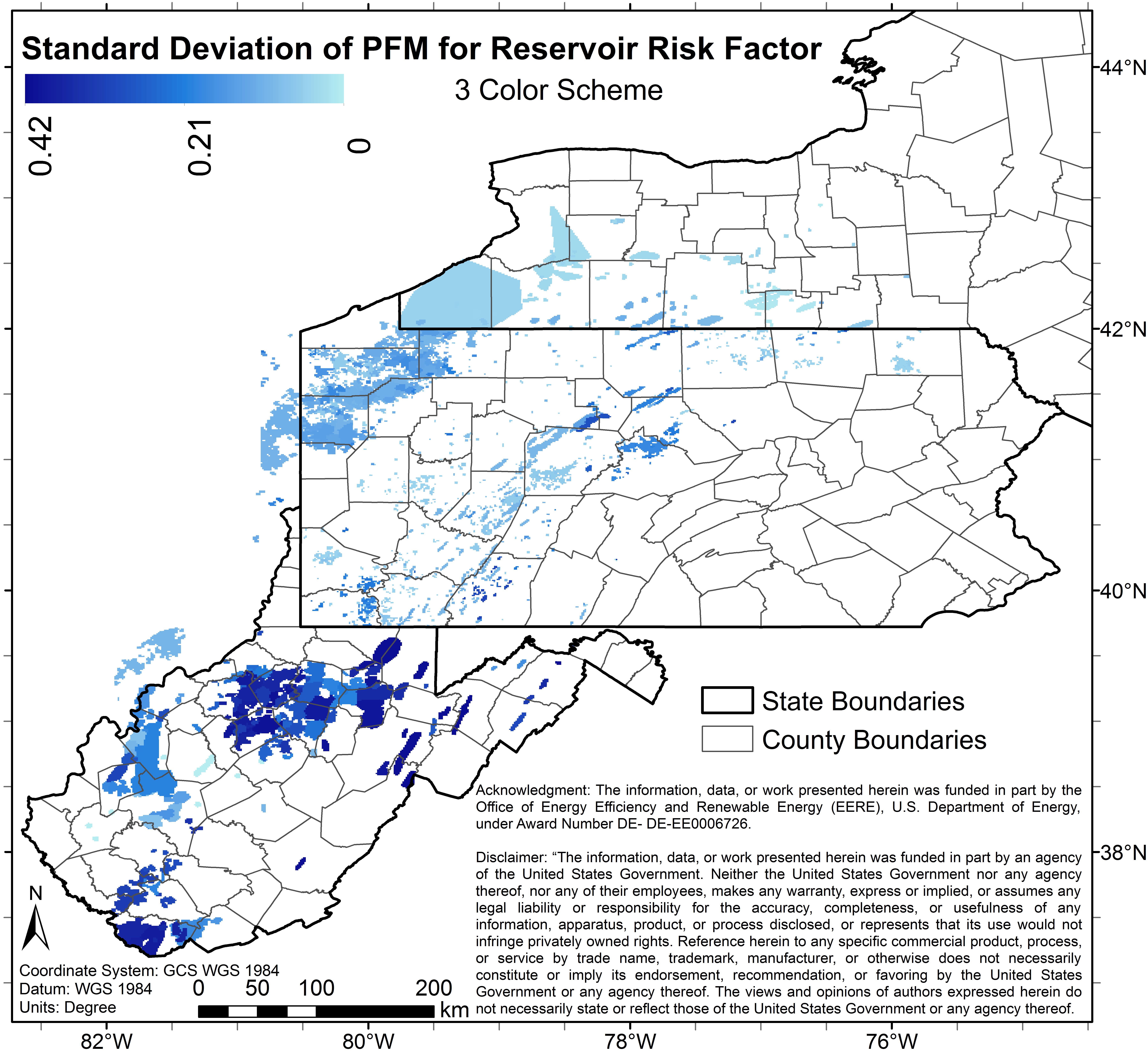
re_pfa_sd3.pngPNG
Image File of the uncertainty (standard deviation) associated with the 3...
-
co_3_0_3_m_geo.pngPNG
3 color map (Image File) of study area depicting predicted combined risks...
-
co_5_0_5_m_geo.pngPNG
5 color map (Image File) of study area depicting predicted combined risks...
-
co_3_0_3_m_egs.pngPNG
3 color map (Image File) of study area depicting predicted combined risks...
-
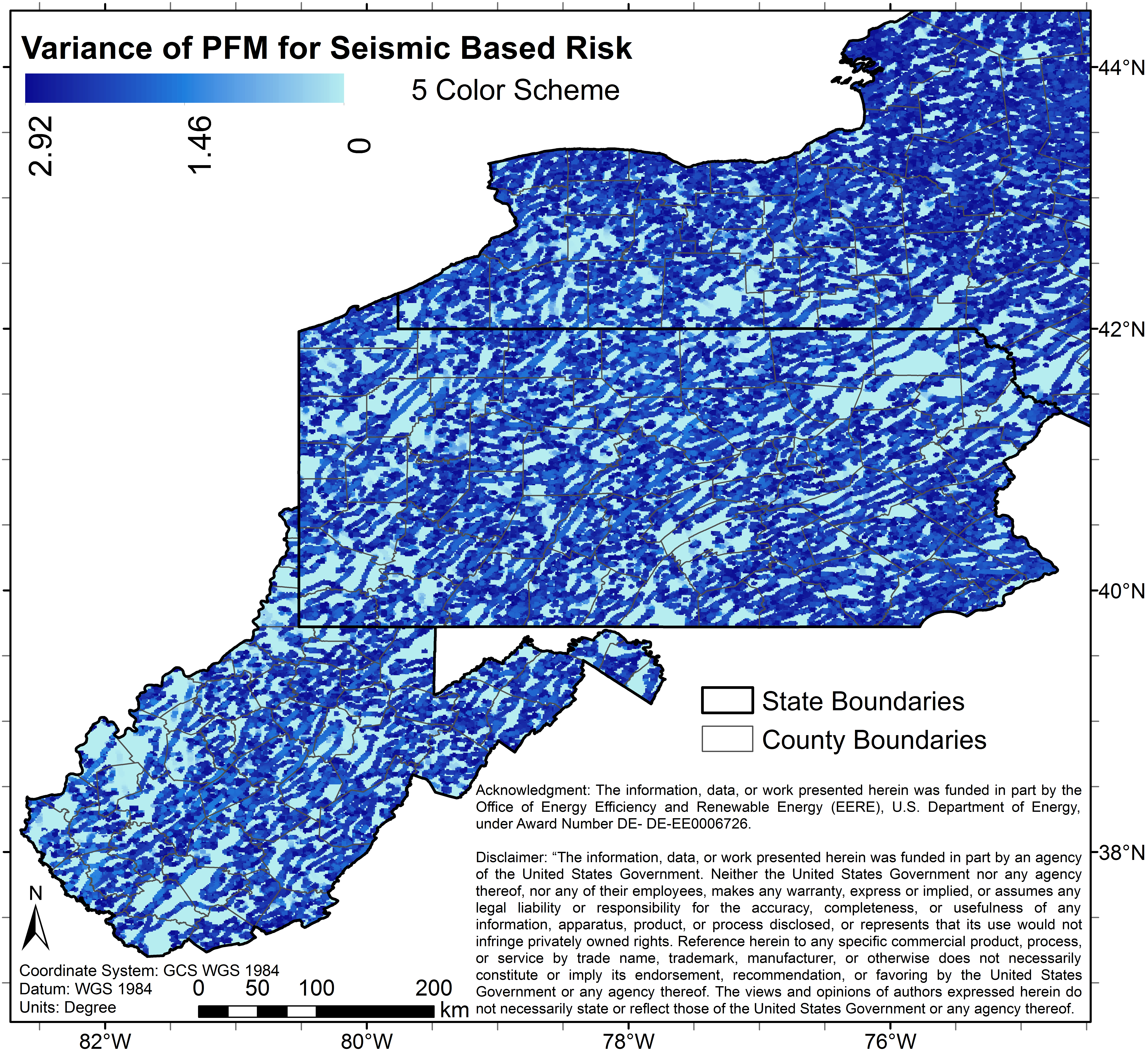
sest_var5.pngPNG
Image File of the uncertainty (variance) associated with 5 color map (Image...
-
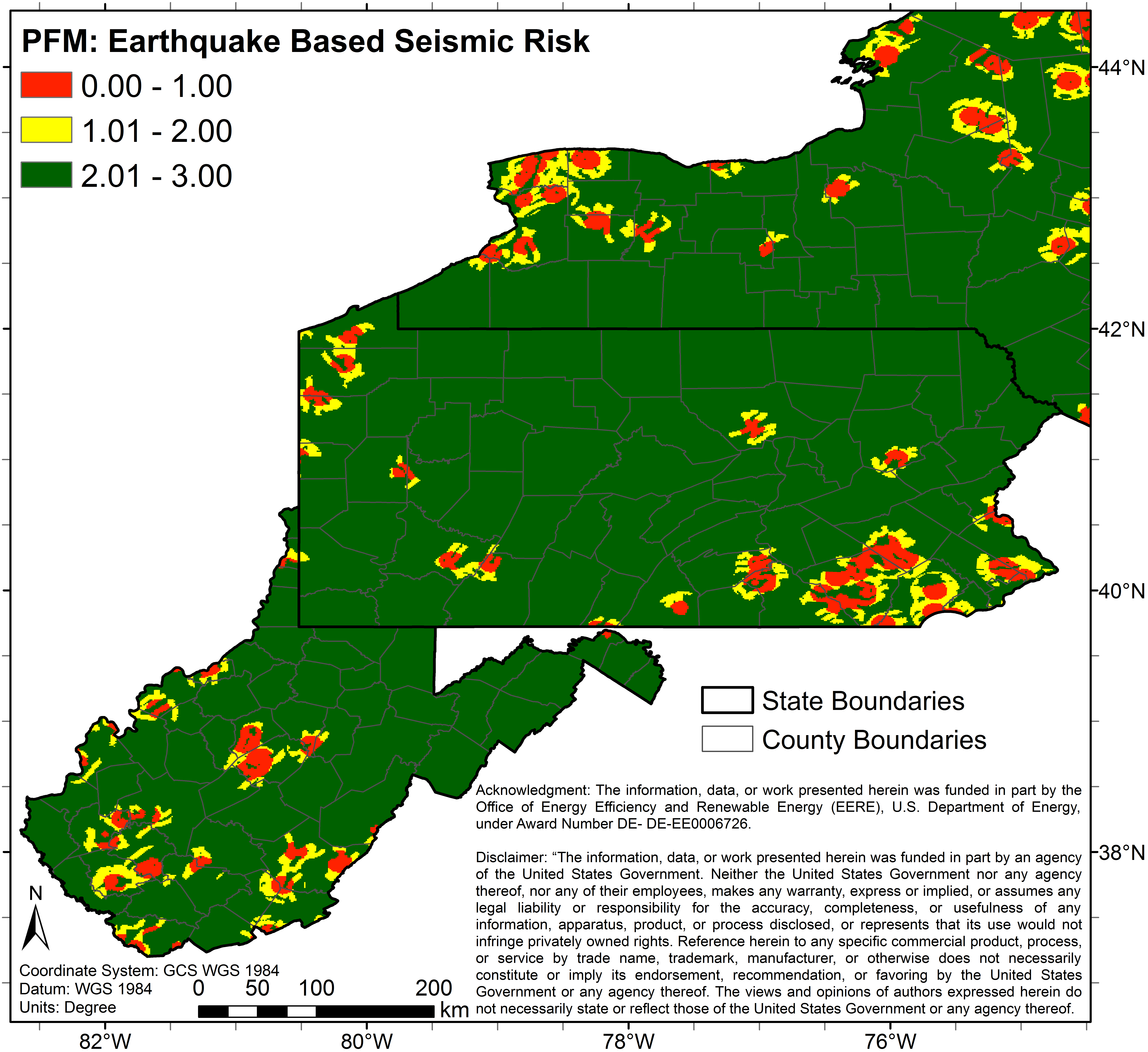
se_3_0_3_a.pngPNG
3 color map (Image File) of study area depicting predicted combined seismic...
-
co_5_0_125_p_egs.pngPNG
5 color map (Image File) of study area depicting predicted combined risks...
-
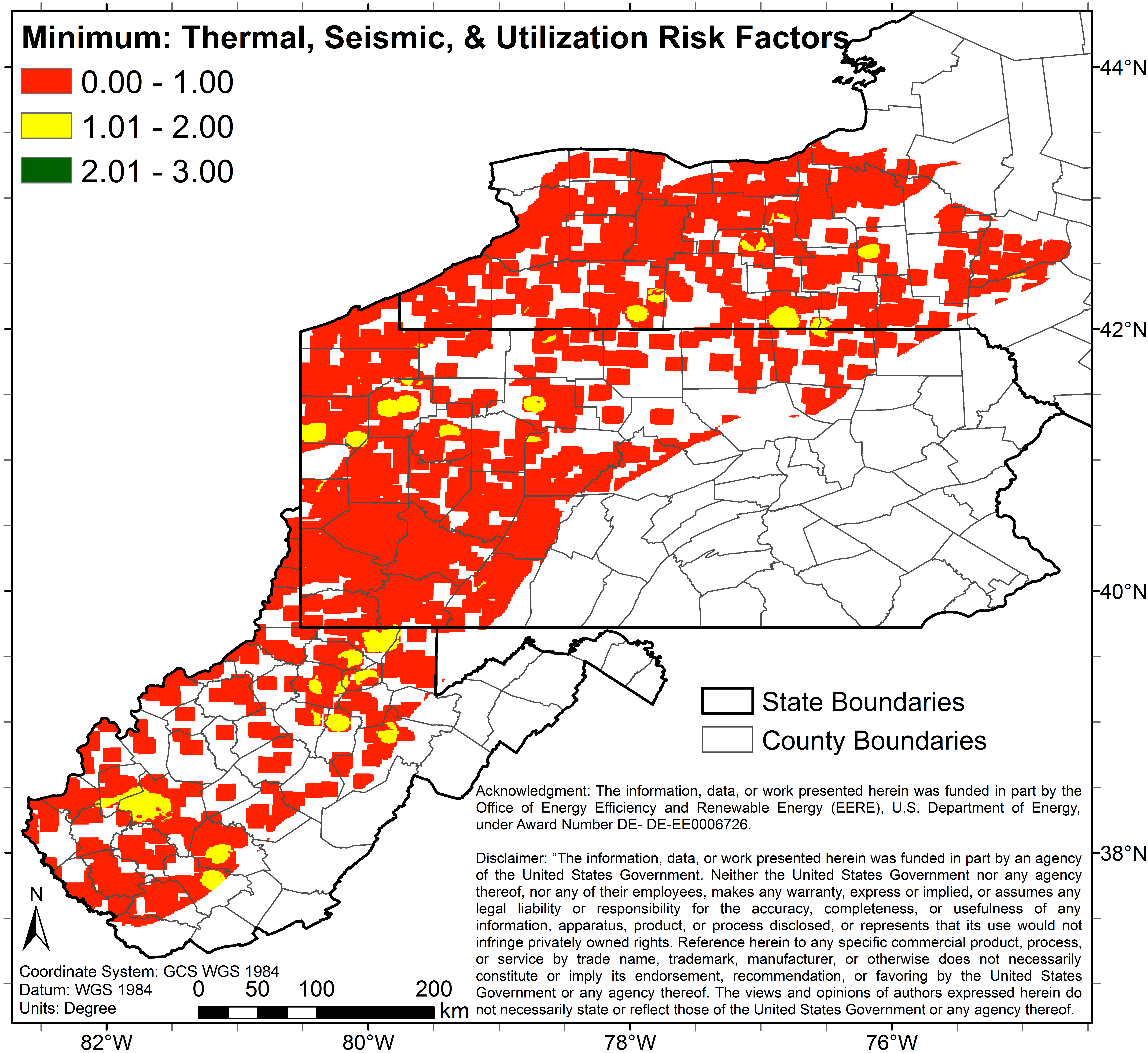
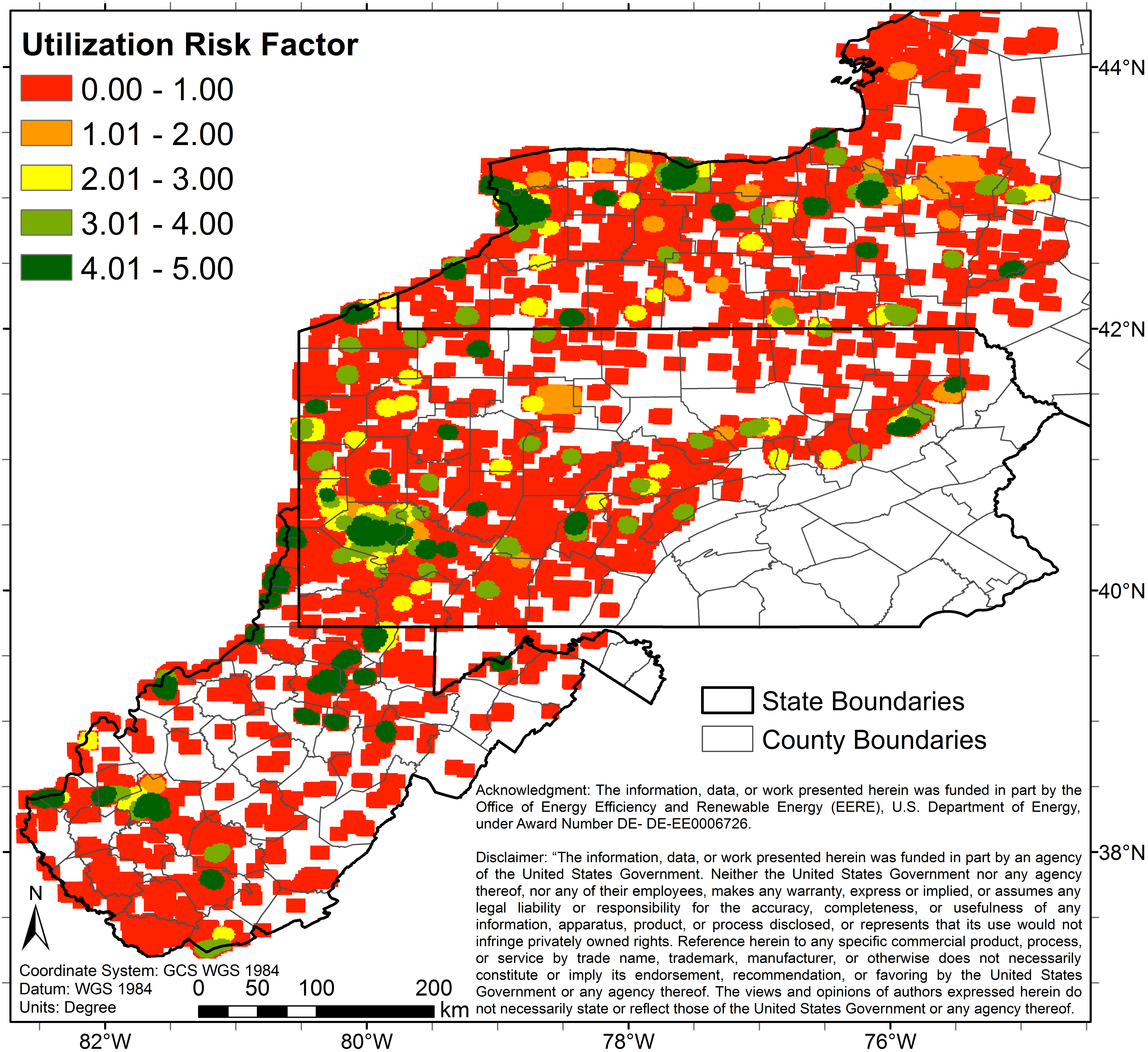
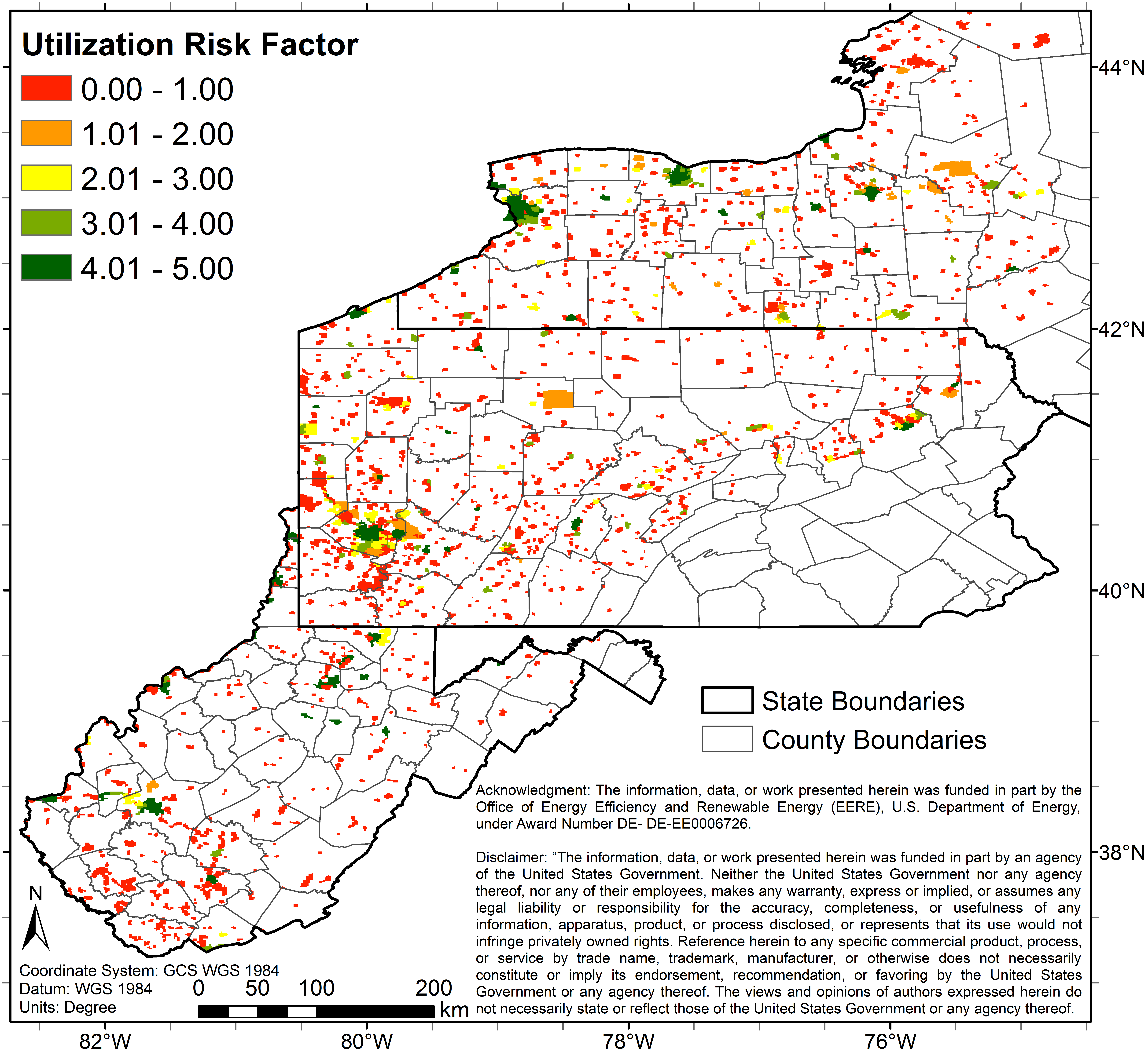
ut5_5_0_5_NA.pngPNG
5 color map (Image File) of study area depicting predicted utilization(SLCOH)...
-
seeq_var5.pngPNG
Image File of the uncertainty (variance) associated with 5 color map (Image...
-
co_3_0_12_s.pngPNG
3 color map (Image File) of study area depicting predicted combined risks...
-
re_pfa_sd5.pngPNG
Image File of the uncertainty (standard deviation) associated with the 5...
-
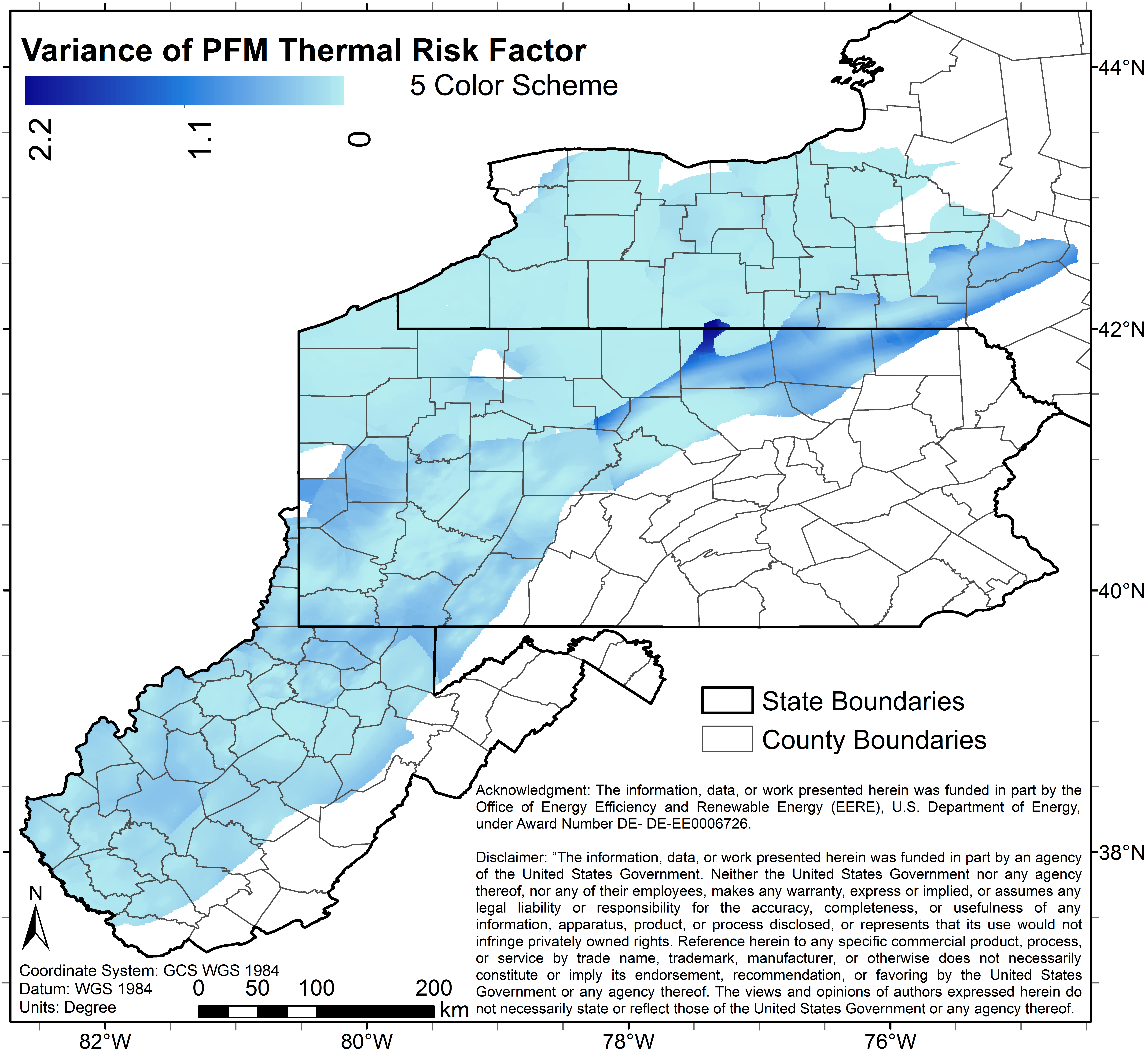
th_pfa_var3.pngPNG
Image File of the uncertainty (variance) associated with the 3 color map...
-
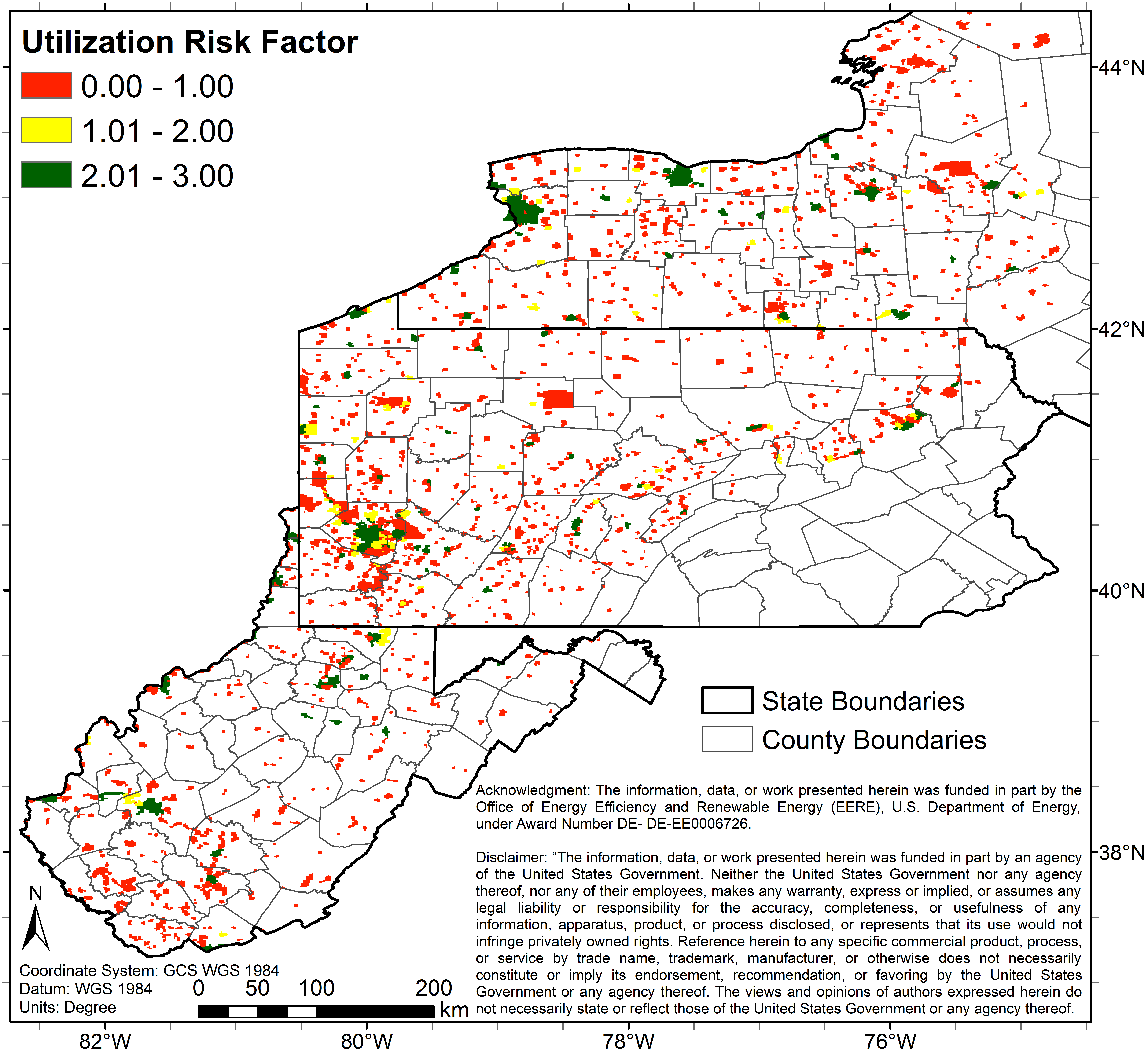
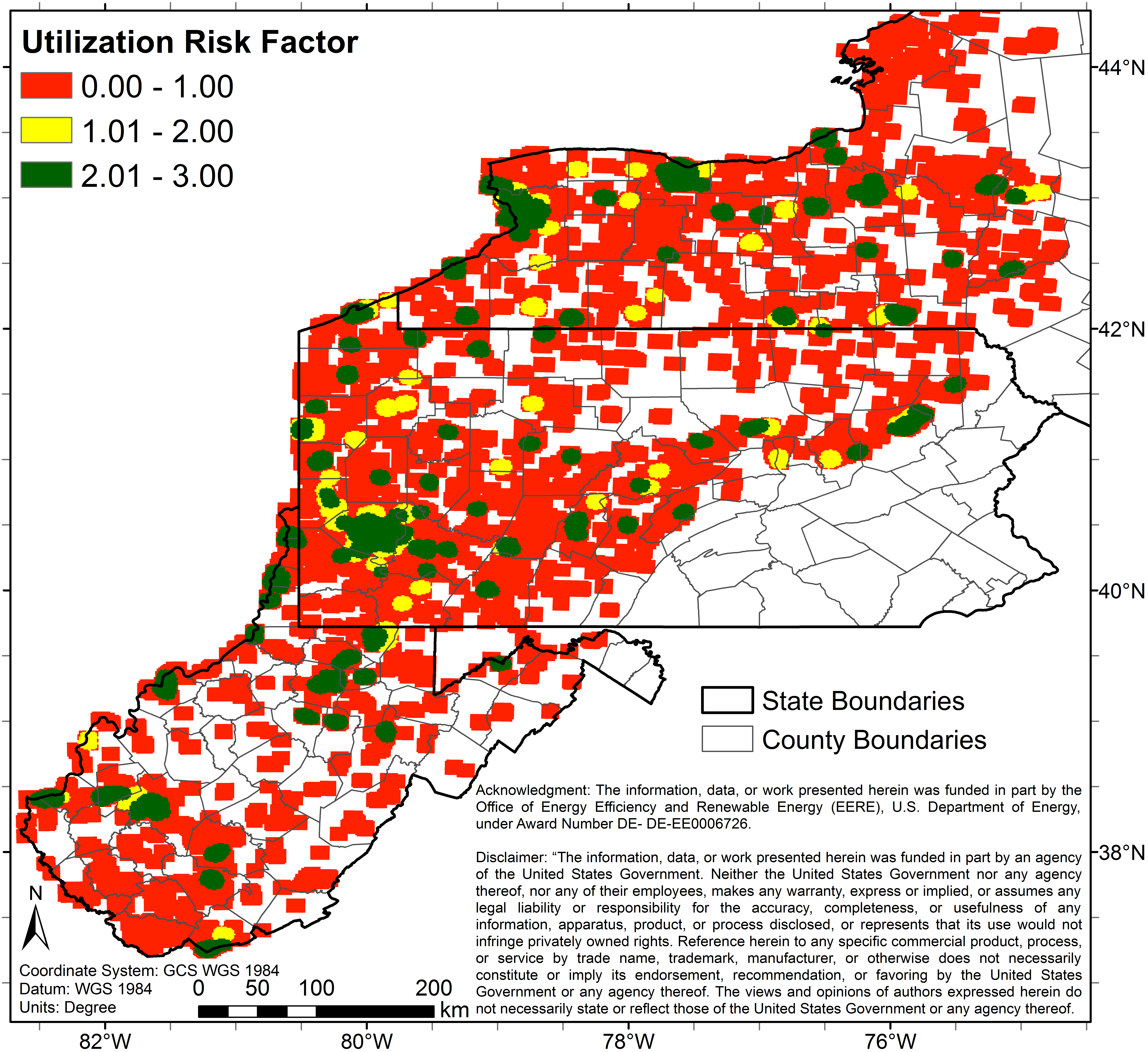
ut0_5_0_5_NA.pngPNG
5 color map (Image File) of study area depicting predicted utilization(SLCOH)...
-
co_3_0_9_s_geo_industries.pngPNG
3 color map (Image File) of study area depicting predicted combined risks...
-
se_pfa_var3.pngPNG
Image File of the uncertainty (variance) associated with the 3 color map...
-
co_5_0_625_p.pngPNG
5 color map (Image File) of study area depicting predicted combined risks...
-
seeq_3_0_3.pngPNG
3 color map (Image File) of study area depicting predicted seismic...
-
co_5_0_15_s_geo.pngPNG
5 color map (Image File) of study area depicting predicted combined risks...
-
co_5_0_5_m_geo_fairways.pngPNG
5 color map (Image File) of study area depicting predicted combined risks...
-
co_3_0_9_s_geo.pngPNG
3 color map (Image File) of study area depicting predicted combined risks...
-
seeq_var3.pngPNG
Image File of the uncertainty (variance) associated with the 3 color map...
-
co_pfa_var3_p_geo.pngPNG
Image File of the uncertainty (variance) associated with the 3 color map...
-
ut0_3_0_3_NA.pngPNG
3 color map (Image File) of study area depicting predicted utilization(SLCOH)...
-
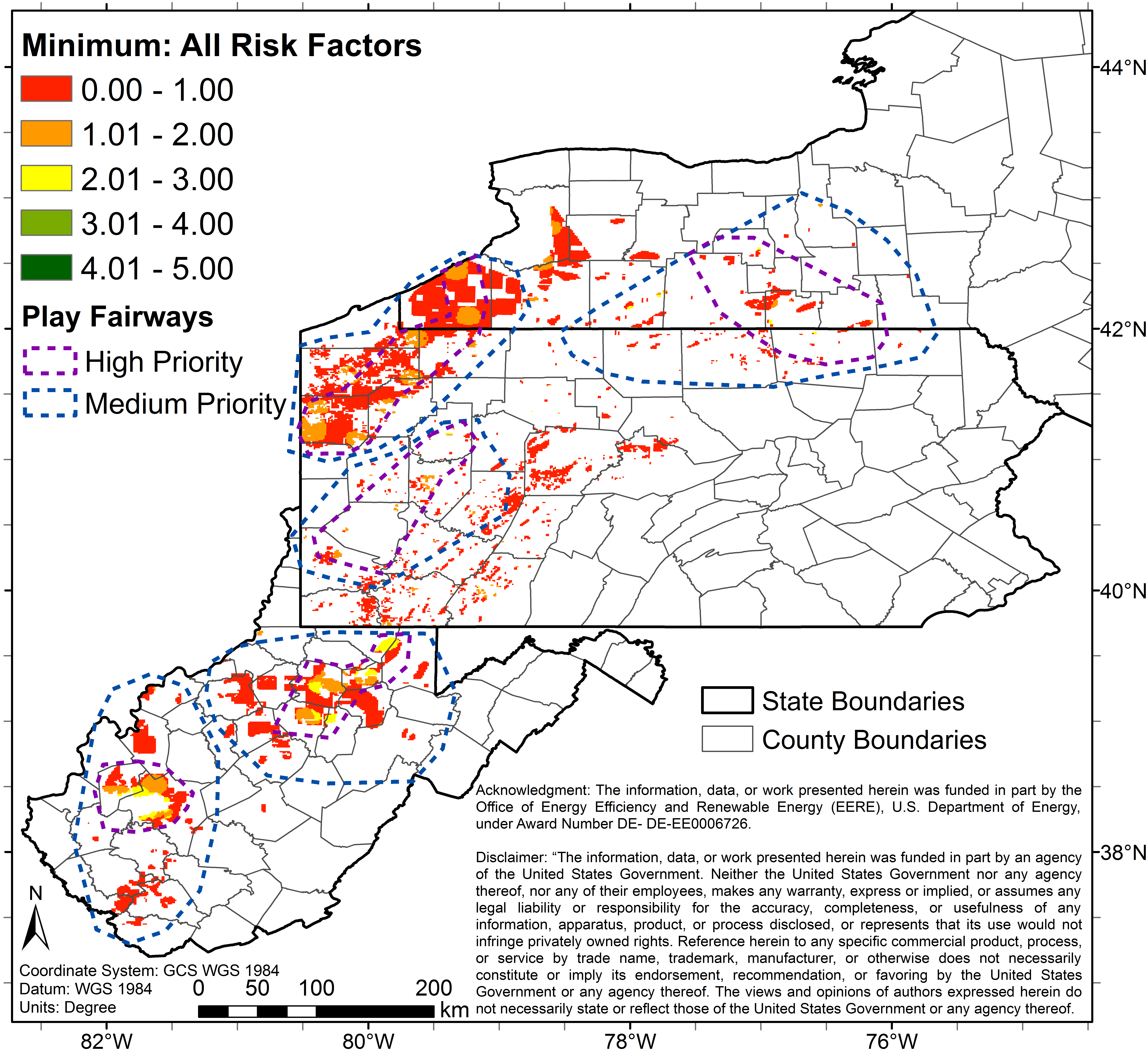
co_3_0_27_p_geo_industries_fairways.pngPNG
3 color map (Image File) of study area depicting predicted combined risks...
-
co_5_0_20_s_fairways.pngPNG
5 color map (Image File) of study area depicting predicted combined risks...
-
co_3_0_12_s_fairways.pngPNG
3 color map (Image File) of study area depicting predicted combined risks...
-
co_3_0_27_p_egs.pngPNG
3 color map (Image File) of study area depicting predicted combined risks...
-
co_pfa_var5_p_geo.pngPNG
Image File of the uncertainty (variance) associated with the 5 color map...
-
se_pfa_sd5.pngPNG
Image File of the uncertainty (standard deviation) associated with 5 color...
-
co_3_0_3_m_geo_industries_fairways.pngPNG
3 color map (Image File) of study area depicting predicted combined risks...
-
co_5_0_5_m_geo_industries.pngPNG
5 color map (Image File) of study area depicting predicted combined risks...
-
co_5_0_125_p_geo_fairways.pngPNG
5 color map (Image File) of study area depicting predicted combined risks...
-
seeq_5_0_5.pngPNG
5 color map (Image File) of study area depicting predicted seismic...
-
co_3_0_3_m_geo_industries.pngPNG
3 color map (Image File) of study area depicting predicted combined risks...
-
co_5_0_15_s_geo_industries.pngPNG
5 color map (Image File) of study area depicting predicted combined risks...
-
co_3_0_3_m_fairways.pngPNG
3 color map (Image File) of study area depicting predicted combined risks...
-
co_5_0_15_s_egs.pngPNG
5 color map (Image File) of study area depicting predicted combined risks...
-
co_pfa_var5_s_geo.pngPNG
Image File of the uncertainty (variance) associated with the 5 color map...
-
co_5_0_15_s_geo_industries_fairways.pngPNG
5 color map (Image File) of study area depicting predicted combined risks...
-
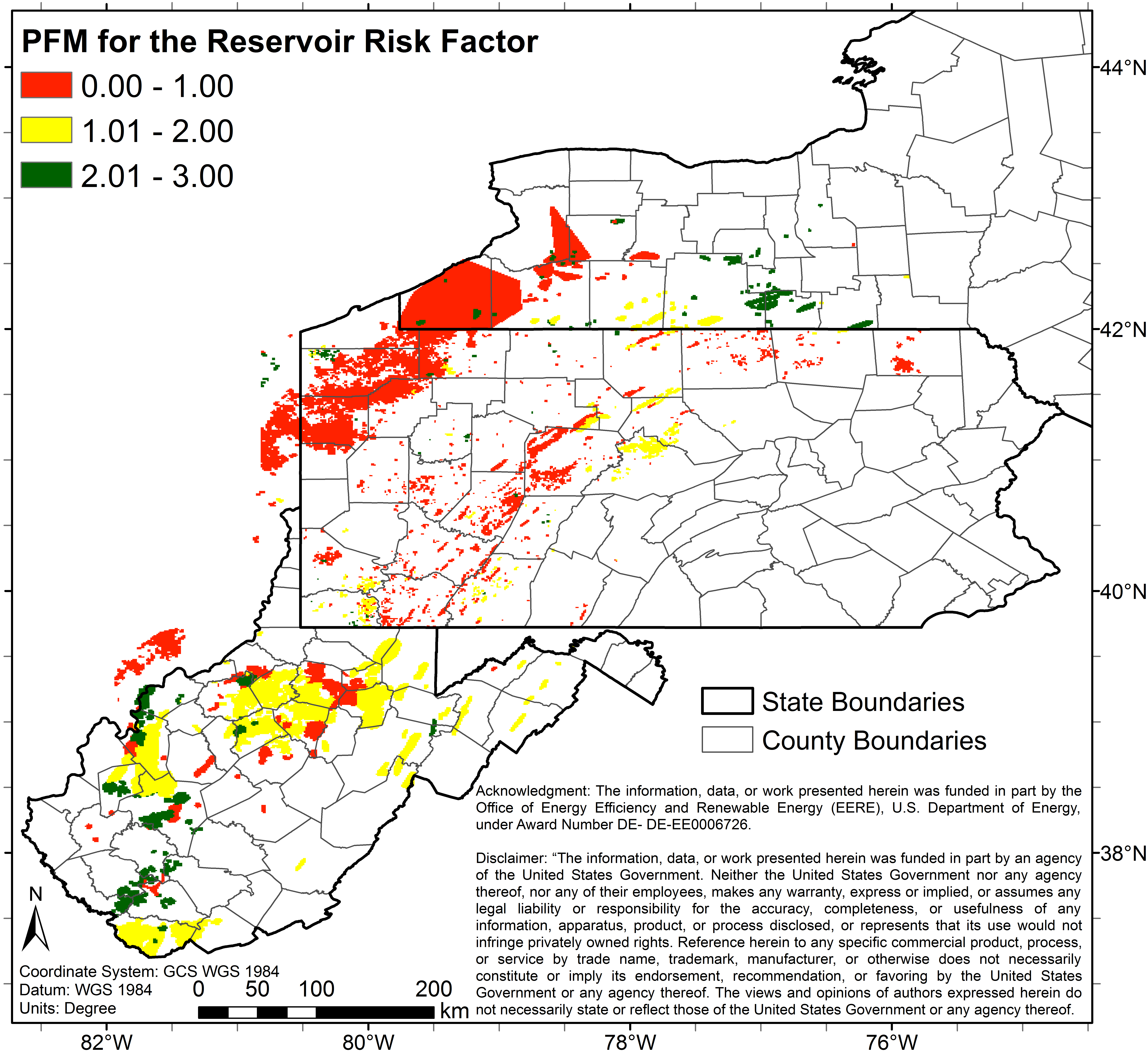
re_5_0_5_NA.pngPNG
5 color map (Image File) of study area depicting predicted reservoirs risk.
-
re_pfa_var5.pngPNG
Image File of the uncertainty (standard deviation) associated with the 5...
-
re_3_0_3_NA.pngPNG
3 color map (Image File) of study area depicting predicted reservoirs risk.
-
co_5_0_5_m_egs.pngPNG
5 color map (Image File) of study area depicting predicted combined risks...
-
co_pfa_sd3_s_geo.pngPNG
Image File of the uncertainty (standard deviation) associated with the 3...
-
th_pfa_var5.pngPNG
Image File of the uncertainty (variance) associated with 5 color map (Image...
-
co_5_0_5_m_geo_industries_fairways.pngPNG
5 color map (Image File) of study area depicting predicted combined risks...
-
se_5_0_5_a.pngPNG
5 color map (Image File) of study area depicting predicted combined seismic...
-
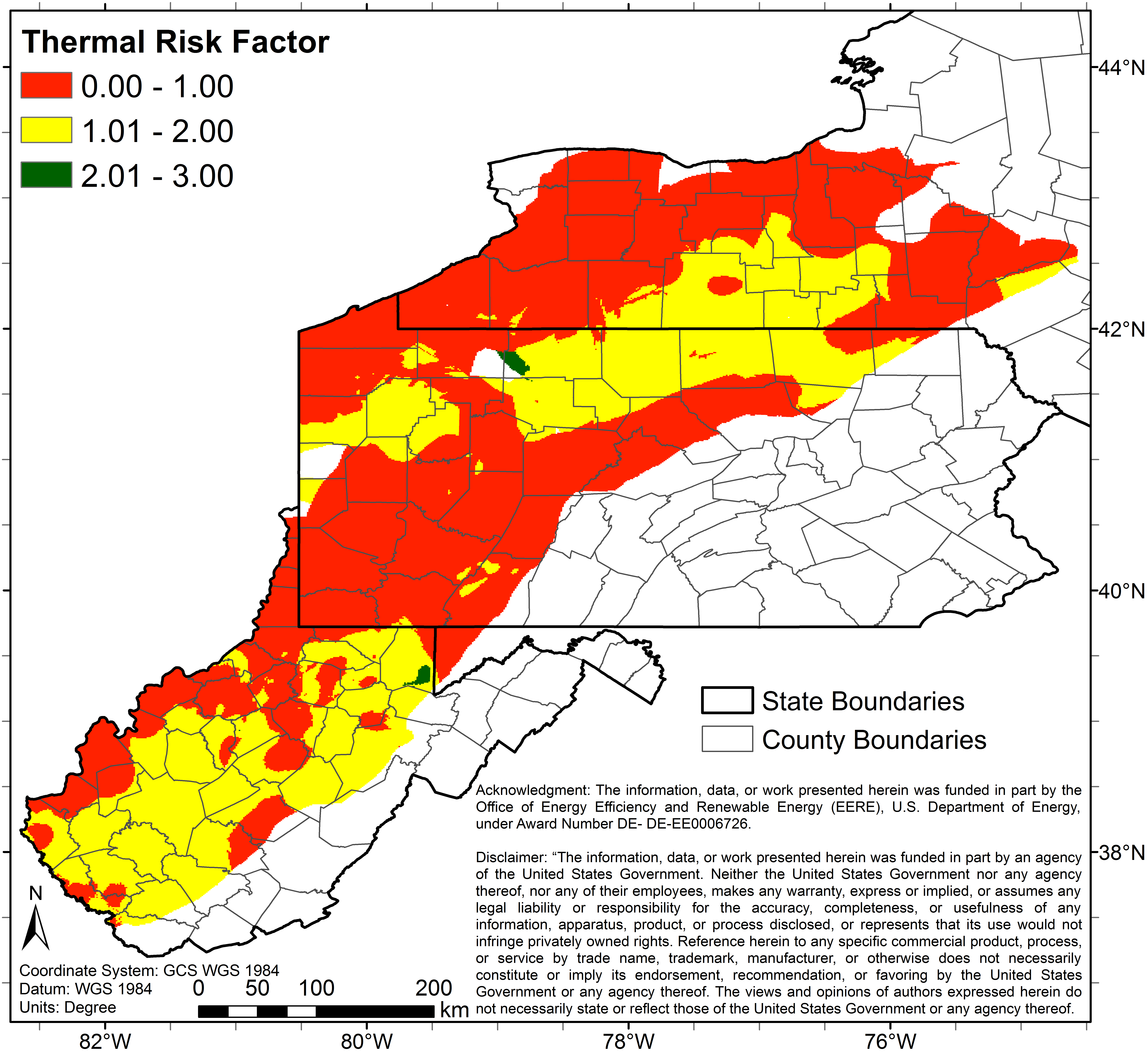
th_3_0_3_NA.pngPNG
3 color map (Image File) of study area depicting predicted thermal risk.
-
co_3_0_27_p_geo_fairways.pngPNG
3 color map (Image File) of study area depicting predicted combined risks...
-
seeq_sd5.pngPNG
Image File of the uncertainty (standard deviation) associated with 5 color...
-
sest_5_0_5.pngPNG
5 color map (Image File) of study area depicting predicted seismic (stress...
-
co_5_0_15_s_geo_fairways.pngPNG
5 color map (Image File) of study area depicting predicted combined risks...
-
co_3_0_9_s_geo_fairways.pngPNG
3 color map (Image File) of study area depicting predicted combined risks...
-
co_3_0_81_p_fairways.pngPNG
3 color map (Image File) of study area depicting predicted combined risks...
-
se_pfa_sd3.pngPNG
Image File of the uncertainty (standard deviation) associated with the 3...
-
th_pfa_sd5.pngPNG
Image File of the uncertainty (standard deviation) associated with 5 color...
-
ut5_3_0_3_NA.pngPNG
3 color map (Image File) of study area depicting predicted utilization(SLCOH)...
-
co_5_0_5_m_fairways.pngPNG
5 color map (Image File) of study area depicting predicted combined risks...
-
co_3_0_27_p_geo.pngPNG
3 color map (Image File) of study area depicting predicted combined risks...
-
co_pfa_sd5_p_geo.pngPNG
Image File of the uncertainty (standard deviation) associated with the 5...
-
co_3_0_3_m_geo_fairways.pngPNG
3 color map (Image File) of study area depicting predicted combined risks...
-
sest_sd3.pngPNG
Image File of the uncertainty (standard deviation) associated with the 3...
-
co_pfa_var3_s_geo.pngPNG
Image File of the uncertainty (variance) associated with the 3 color map...
-
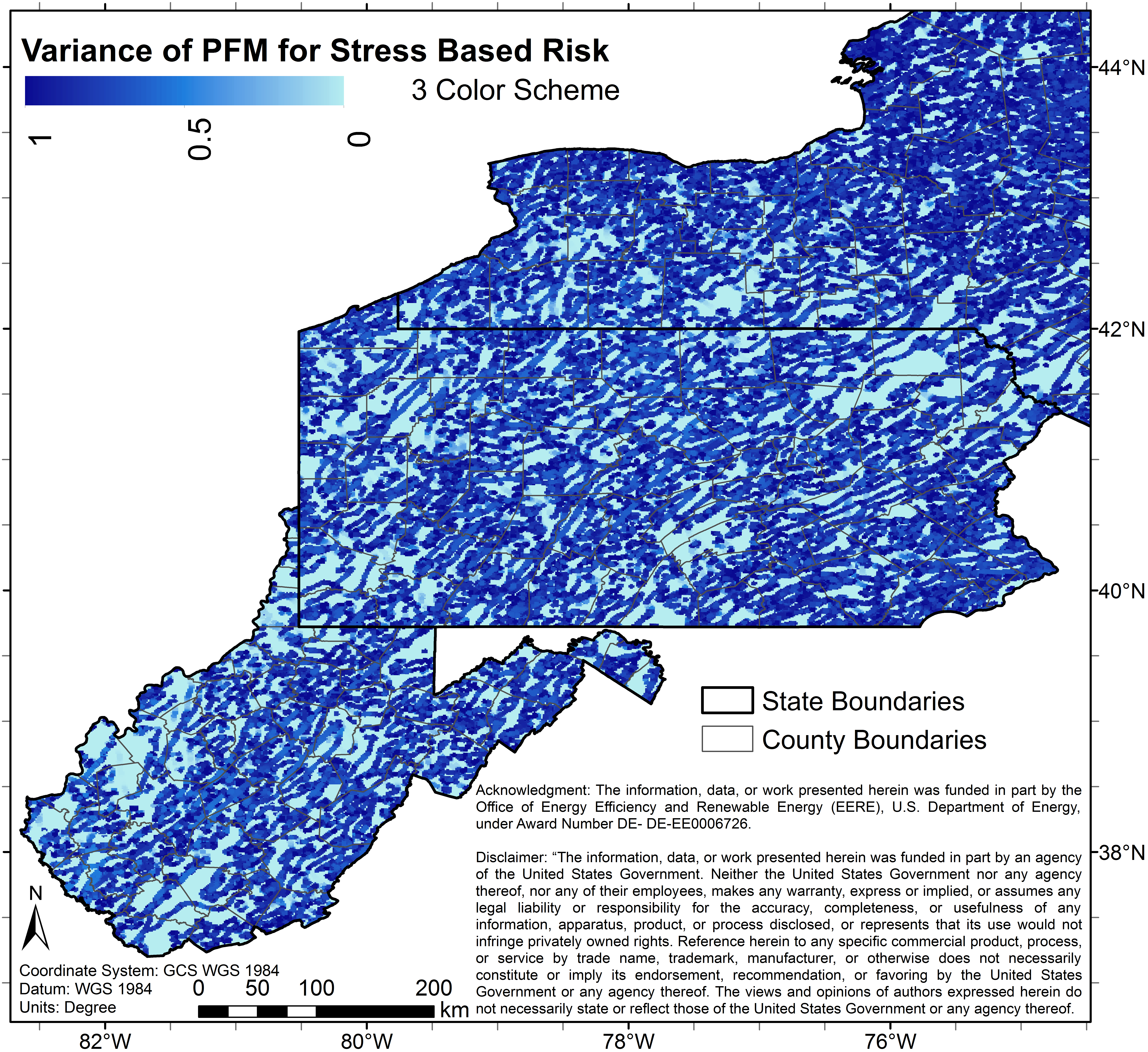
sest_var3.pngPNG
Image File of the uncertainty (variance) associated with the 3 color map...
-
th_5_0_5_NA.pngPNG
5 color map (Image File) of study area depicting predicted thermal risk.
-
co_pfa_var3_s_geo.tifTIFF
Raster File of the uncertainty (variance) associated with the 3 color map...
-
th_pfa_sd3.tifTIFF
Raster File of the uncertainty (standard deviation) associated with the 3...
-
seEq_5_0_5_NA.tifTIFF
5 color map (Raster File) of study area depicting predicted seismic...
-
co_3_0_27_p_geo_fairways.tifTIFF
3 color map (Raster File) of study area depicting predicted combined risks...
-
re_pfa_sd3.tifTIFF
Raster File of the uncertainty (standard deviation) associated with the 3...
-
co_5_0_125_p_geo.tifTIFF
5 color map (Raster File) of study area depicting predicted combined risks...
-
co_pfa_var5_p_geo.tifTIFF
Raster File of the uncertainty (variance) associated with the 5 color map...
-
co_pfa_sd5_p_geo.tifTIFF
Raster File of the uncertainty (standard deviation) associated with the 5...
-
re_3_0_3_NA.tifTIFF
3 color map (Raster File) of study area depicting predicted reservoirs risk.
-
seSt_5_0_5_NA.tifTIFF
5 color map (Raster File) of study area depicting predicted seismic stress...
-
co_3_0_12_s.tifTIFF
3 color map (Raster File) of study area depicting predicted combined risks...
-
co_5_0_125_p_egs.tifTIFF
5 color map (Raster File) of study area depicting predicted combined risks...
-
seSt_3_0_3_NA.tifTIFF
3 color map (Raster File) of study area depicting predicted seismic stress...
-
seSt_pfa_var5.tifTIFF
Raster File of the uncertainty (variance) associated with 5 color map (Raster...
-
seSt_pfa_sd5.tifTIFF
Raster File of the uncertainty (standard deviation) associated with 5 color...
-
th_pfa_var3.tifTIFF
Raster File of the uncertainty (variance) associated with the 3 color map...
-
th_5_0_5_NA.tifTIFF
5 color map (Raster File) of study area depicting predicted thermal risk.
-
th_pfa_var5.tifTIFF
Raster File of the uncertainty (variance) associated with 5 color map (Raster...
-
seEq_pfa_var5.tifTIFF
Raster File of the uncertainty (variance) associated with 5 color map (Raster...
-
co_pfa_var3_p_geo.tifTIFF
Raster File of the uncertainty (variance) associated with the 3 color map...
-
th_pfa_sd5.tifTIFF
Raster File of the uncertainty (standard deviation) associated with 5 color...
-
co_5_0_5_m_geo.tifTIFF
5 color map (Raster File) of study area depicting predicted combined risks...
-
re_5_0_5_NA.tifTIFF
5 color map (Raster File) of study area depicting predicted reservoirs risk.
-
se_3_0_3_a.tifTIFF
3 color map (Raster File) of study area depicting predicted combined seismic...
-
se_pfa_var3.tifTIFF
Raster File of the uncertainty (variance) associated with the 3 color map...
-
co_5_0_5_m.tifTIFF
5 color map (Raster File) of study area depicting predicted combined risks...
-
co_pfa_sd3_p_geo.tifTIFF
Raster File of the uncertainty (standard deviation) associated with the 3...
-
ut0_3_0_3_NA.tifTIFF
3 color map (Raster File) of study area depicting predicted...
-
co_5_0_5_m_egs.tifTIFF
5 color map (Raster File) of study area depicting predicted combined risks...
-
seSt_pfa_sd3.tifTIFF
Raster File of the uncertainty (standard deviation) associated with the 3...
-
co_3_0_27_p_egs.tifTIFF
3 color map (Raster File) of study area depicting predicted combined risks...
-
ut5_5_0_5_NA.tifTIFF
5 color map (Raster File) of study area depicting predicted...
-
co_5_0_15_s_geo.tifTIFF
5 color map (Raster File) of study area depicting predicted combined risks...
-
re_pfa_sd5.tifTIFF
Raster File of the uncertainty (standard deviation) associated with the 5...
-
re_pfa_var3.tifTIFF
Raster File of the uncertainty (variance) associated with the 3 color map...
-
seEq_pfa_sd3.tifTIFF
Raster File of the uncertainty (standard deviation) associated with the 3...
-
co_3_0_9_s_egs.tifTIFF
3 color map (Raster File) of study area depicting predicted combined risks...
-
co_3_0_3_m_egs.tifTIFF
3 color map (Raster File) of study area depicting predicted combined risks...
-
co_3_0_3_m_geo.tifTIFF
3 color map (Raster File) of study area depicting predicted combined risks...
-
co_3_0_3_m.tifTIFF
3 color map (Raster File) of study area depicting predicted combined risks...
-
seSt_pfa_var3.tifTIFF
Raster File of the uncertainty (variance) associated with the 3 color map...
-
se_5_0_5_a.tifTIFF
5 color map (Raster File) of study area depicting predicted combined seismic...
-
se_pfa_sd5.tifTIFF
Raster File of the uncertainty (standard deviation) associated with 5 color...
-
ut5_3_0_3_NA.tifTIFF
3 color map (Raster File) of study area depicting predicted...
-
th_3_0_3_NA.tifTIFF
3 color map (Raster File) of study area depicting predicted thermal risk.
-
co_5_0_20_s.tifTIFF
5 color map (Raster File) of study area depicting predicted combined risks...
-
ut0_5_0_5_NA.tifTIFF
5 color map (Raster File) of study area depicting predicted...
-
co_5_0_625_p.tifTIFF
5 color map (Raster File) of study area depicting predicted combined risks...
-
seEq_3_0_3_NA.tifTIFF
3 color map (Raster File) of study area depicting predicted seismic...
-
co_pfa_sd3_s_geo.tifTIFF
Raster File of the uncertainty (standard deviation) associated with the 3...
-
co_pfa_sd5_s_geo.tifTIFF
Raster File of the uncertainty (standard deviation) associated with the 5...
-
se_pfa_var5.tifTIFF
Raster File of the uncertainty (variance) associated with 5 color map (Raster...
-
seEq_pfa_sd5.tifTIFF
Raster File of the uncertainty (standard deviation) associated with 5 color...
-
co_5_0_15_s_egs.tifTIFF
5 color map (Raster File) of study area depicting predicted combined risks...
-
co_3_0_9_s_geo.tifTIFF
3 color map (Raster File) of study area depicting predicted combined risks...
-
co_pfa_var5_s_geo.tifTIFF
Raster File of the uncertainty (variance) associated with the 5 color map...
-
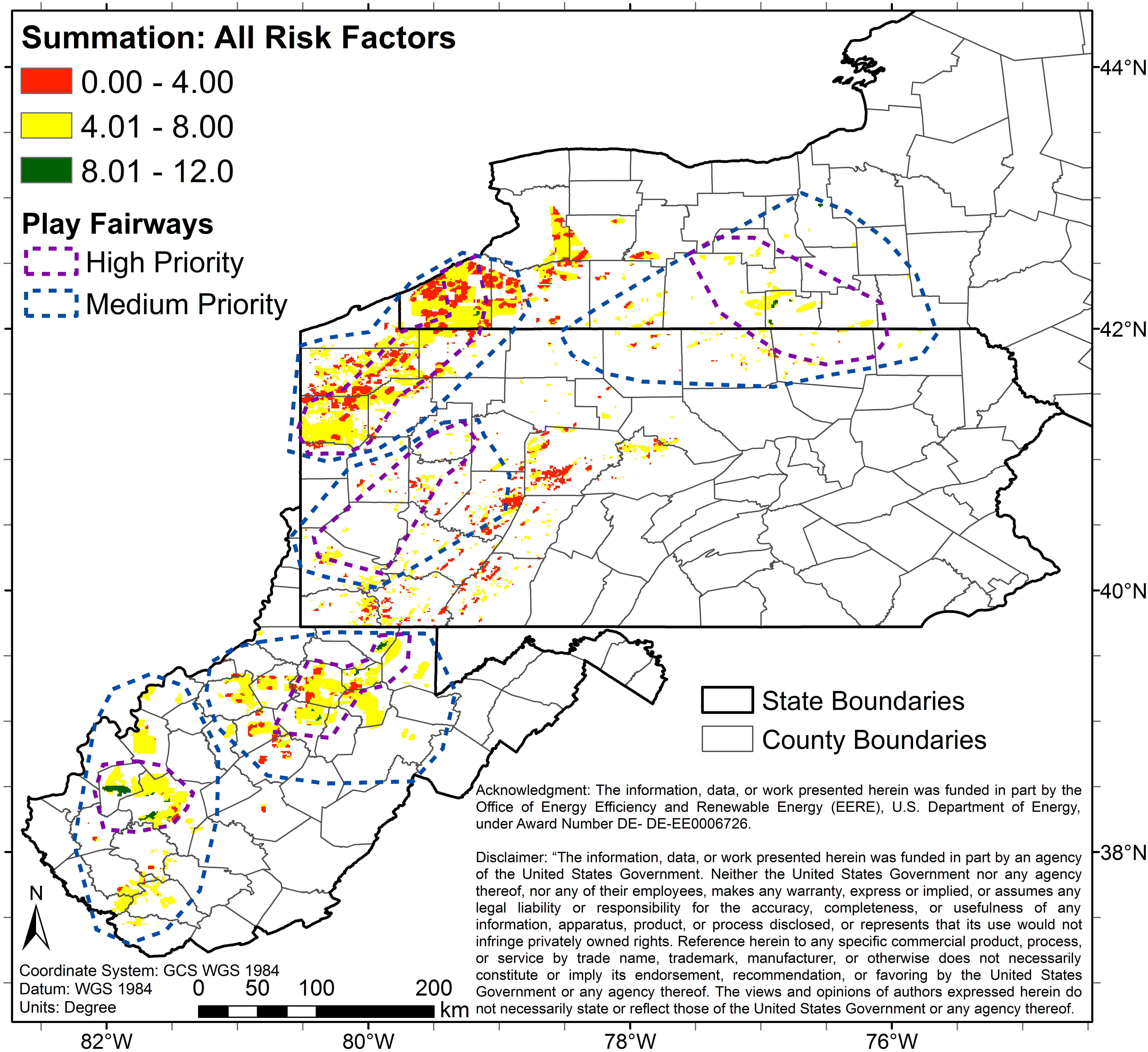
co_3_0_81_p.tifTIFF
3 color map (Raster File) of study area depicting predicted combined risks...
-
se_pfa_sd3.tifTIFF
Raster File of the uncertainty (standard deviation) associated with the 3...
-
seEq_pfa_var3.tifTIFF
Raster File of the uncertainty (variance) associated with the 3 color map...
-
re_pfa_var5.tifTIFF
Raster File of the uncertainty (standard deviation) associated with the 5...
-
List of Contents.csvCSV
Listing of all files and folders within the GPFA-...
-
GPFA-AB_combining_risk_factors.pdfPDF
Comprehensive explanation of the methodology (procedures, assumptions, etc.)...
-
Fishnet2_label.shpSHP
Shapefile defining center of raster cells used in producing the Task 5 Risk...
-
Fishnet2_label.shxshx
Associated file for use with shapefile defining center of raster cells used...
-
Fishnet2_label.prjprj
Associated file for use with shapefile defining center of raster cells used...
-
Fishnet2_label.cpgcpg
Associated file for use with shapefile defining center of raster cells used...
-
Fishnet2_label.shp.xmlXML
Associated file for use with shapefile defining center of raster cells used...
-
Fishnet2_label.dbfdBase
Associated file for use with shapefile defining center of raster cells used...
-
placesofinterest2.qpjqpj
Associated file for use with shapefile defining places of interest in Phase 1...
-
placesofinterest2.cpgcpg
Associated file for use with shapefile defining places of interest in Phase 1...
-
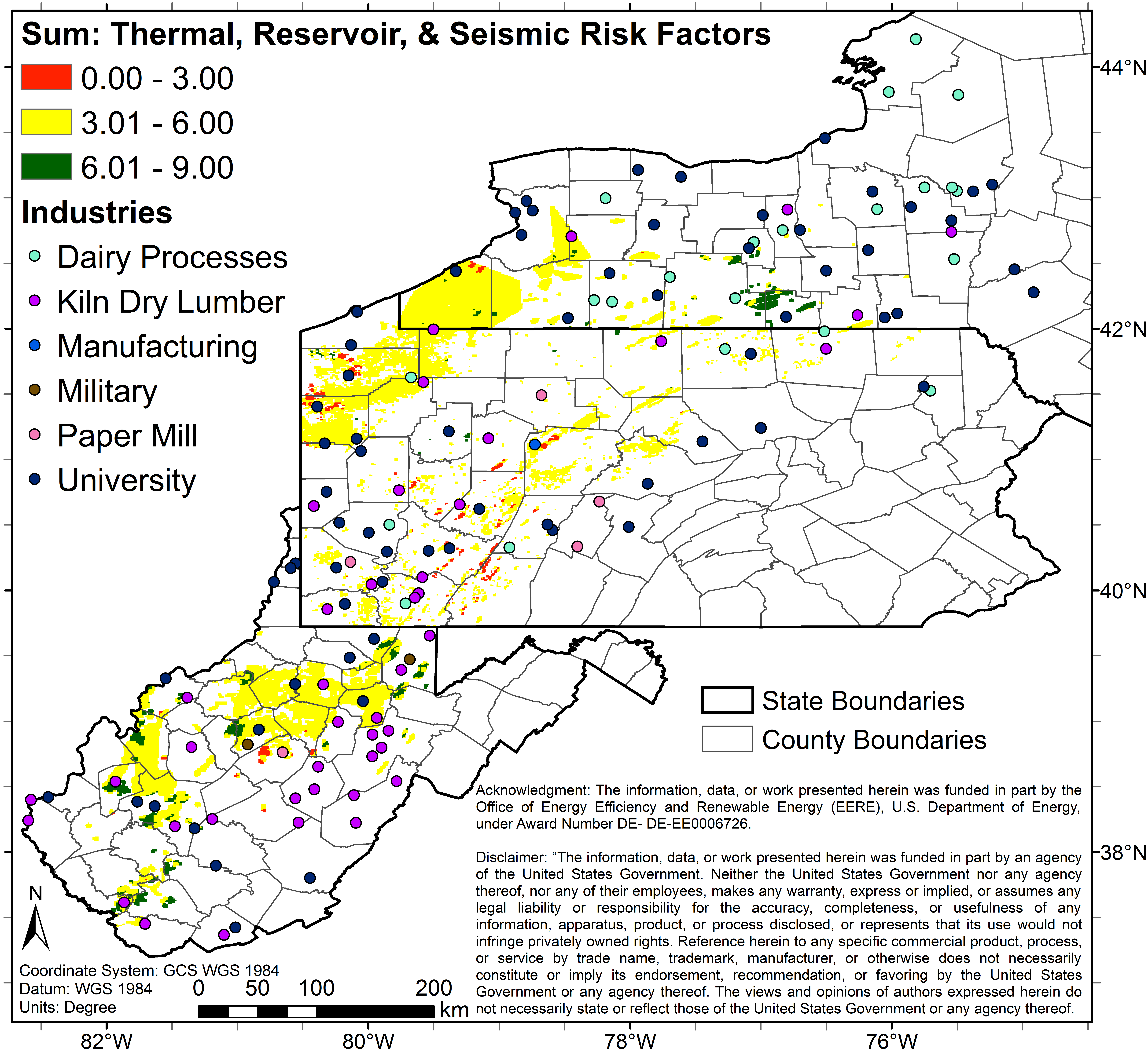
placesofinterest2.shpSHP
Shapefile defining places of interest in Phase 1 of GPFA-AB for low-...
-
placesofinterest2.prjprj
Associated file for use with shapefile defining places of interest in Phase 1...
-
placesofinterest2.shxshx
Associated file for use with shapefile defining places of interest in Phase 1...
-
placesofinterest2.dbfdBase
Associated file for use with shapefile defining places of interest in Phase 1...
-
usCensusPlaces.qpjqpj
Associated file for use with shapefile defining US Census Bureau 'Places'...
-
usCensusPlaces.cpgcpg
Associated file for use with shapefile defining US Census Bureau 'Places'...
-
usCensusPlaces.dbfdBase
Associated file for use with shapefile defining US Census Bureau 'Places'...
-
usCensusPlaces.prjprj
Associated file for use with shapefile defining US Census Bureau 'Places'...
-
usCensusPlaces.shpSHP
Shapefile defining US Census Bureau 'Places' used in Phase 1 of GPFA-AB Task...
-
usCensusPlaces.shxshx
Associated file for use with shapefile defining US Census Bureau 'Places'...
-
usCensusPlaces.csvCSV
Spreadsheet of US Census Bureau 'Places' used in Phase 1 of GPFA-AB Task 4...
-
FixedQ2.prjprj
Associated file for use with shapefile defining higher priority ('inner')...
-
FixedQ2.cpgcpg
Associated file for use with shapefile defining higher priority ('inner')...
-
HighPriority.lyrlyr
Associated file for use with shapefile defining higher priority ('inner')...
-
FixedQ2.dbfdBase
Associated file for use with shapefile defining higher priority ('inner')...
-
FixedQ2.sbxsbx
Associated file for use with shapefile defining higher priority ('inner')...
-
FixedQ2.sbnsbn
Associated file for use with shapefile defining higher priority ('inner')...
-
FixedQ2.shxshx
Associated file for use with shapefile defining higher priority ('inner')...
-
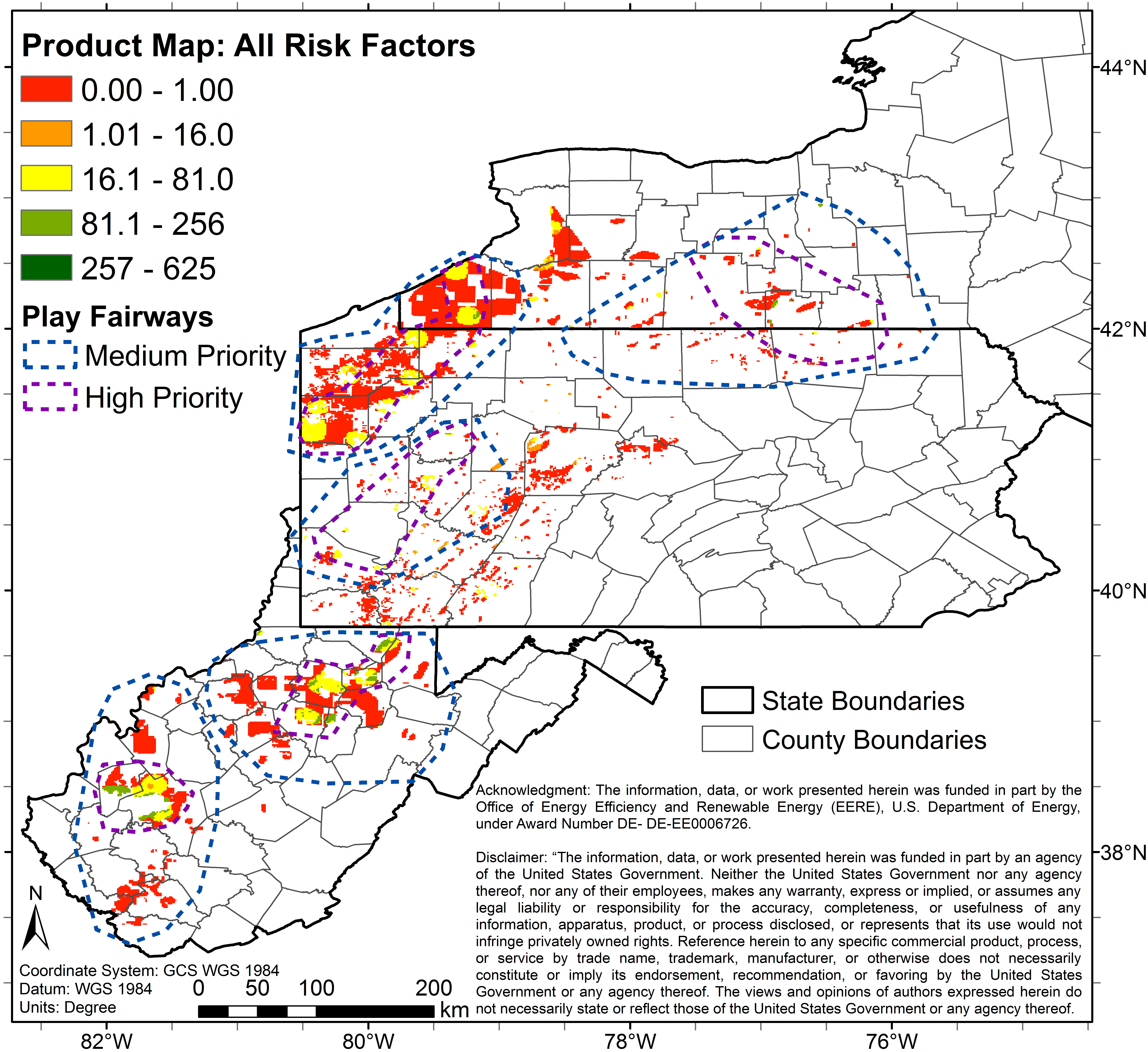
FixedQ2.shpSHP
Shapefile defining higher priority ('inner') geothermal fairways identified...
-
Industries_FINAL.sbnsbn
Associated file for use with shapefile defining prospective sites within...
-
Industries_FINAL.prjprj
Associated file for use with shapefile defining prospective sites within...
-
Industries_FINAL.shpSHP
Associated file for use with shapefile defining prospective sites within...
-
Industries_FINAL.dbfdBase
Associated file for use with shapefile defining prospective sites within...
-
Industries_FINAL.shxshx
Associated file for use with shapefile defining prospective sites within...
-
Industries_FINAL.sbxsbx
Shapefile defining prospective sites within GPFA-AB study area for low-...
-
Industries_FINAL.lyrlyr
Associated file for use with shapefile defining prospective sites within...
-
Industries_FINAL.cpgcpg
Associated file for use with shapefile defining prospective sites within...
-
fairwaysOuter.shxshx
Associated file for use with shapefile defining boader ('outer') geothermal...
-
MediumPriority.lyrlyr
Associated file for use with shapefile defining boader ('outer') geothermal...
-
fairwaysOuter.dbfdBase
Associated file for use with shapefile defining boader ('outer') geothermal...
-
fairwaysOuter.cpgcpg
Associated file for use with shapefile defining boader ('outer') geothermal...
-
fairwaysOuter.shpSHP
Shapefile defining boader ('outer') geothermal fairways identified in Phase 1...
-
fairwaysOuter.prjprj
Associated file for use with shapefile defining boader ('outer') geothermal...
-
fairwaysOuter.qpjqpj
Associated file for use with shapefile defining boader ('outer') geothermal...
-
Code for CalculationsHTML
See folder "combining_metrics" for code used to calculate values
-
GPFA-AB.zipZIP
A compressed and organized folder containing all of the files associated with...
-
Landing PageLanding Page
Dates
| Metadata Created Date | January 11, 2025 |
|---|---|
| Metadata Updated Date | January 20, 2025 |
Metadata Source
- Data.json Data.json Metadata
Harvested from OpenEI data.json
Additional Metadata
| Resource Type | Dataset |
|---|---|
| Metadata Created Date | January 11, 2025 |
| Metadata Updated Date | January 20, 2025 |
| Publisher | Cornell University |
| Maintainer | |
| Doi | 10.15121/1261942 |
| Identifier | https://data.openei.org/submissions/6867 |
| Data First Published | 2015-09-30T06:00:00Z |
| Data Last Modified | 2020-01-10T17:50:55Z |
| Public Access Level | public |
| Bureau Code | 019:20 |
| Metadata Context | https://openei.org/data.json |
| Metadata Catalog ID | https://openei.org/data.json |
| Schema Version | https://project-open-data.cio.gov/v1.1/schema |
| Catalog Describedby | https://project-open-data.cio.gov/v1.1/schema/catalog.json |
| Data Quality | True |
| Datagov Dedupe Retained | 20250120143002 |
| Harvest Object Id | 967c8d3b-00c1-43b6-b24a-dfe6a5051751 |
| Harvest Source Id | 7cbf9085-0290-4e9f-bec1-91653baeddfd |
| Harvest Source Title | OpenEI data.json |
| Homepage URL | https://gdr.openei.org/submissions/622 |
| License | https://creativecommons.org/licenses/by/4.0/ |
| Old Spatial | {"type":"Polygon","coordinates":-167.7267,13.518,-53.8316,13.518,-53.8316,75.0714,-167.7267,75.0714,-167.7267,13.518} |
| Program Code | 019:006 |
| Projectlead | Holly Thomas |
| Projectnumber | EE0006726 |
| Projecttitle | Low Temperature Geothermal Play Fairway Analysis for the Appalachian Basin |
| Source Datajson Identifier | True |
| Source Hash | 6e57597378098c61c1ad71d68f1c352514fec00a22010f92c5059e115c82ed17 |
| Source Schema Version | 1.1 |
| Spatial | {"type":"Polygon","coordinates":-167.7267,13.518,-53.8316,13.518,-53.8316,75.0714,-167.7267,75.0714,-167.7267,13.518} |
Didn't find what you're looking for? Suggest a dataset here.