
-
Federal
NOAA Environmental Sensitivity Index (ESI) maps and geographic information systems data from 1900 to 2009
National Oceanic and Atmospheric Administration, Department of Commerce —
This collection comprises the Environmental Sensitivity Index (ESI) data for various regions in U.S. coastal waters. ESI data characterize estuarine environments and... -
Federal
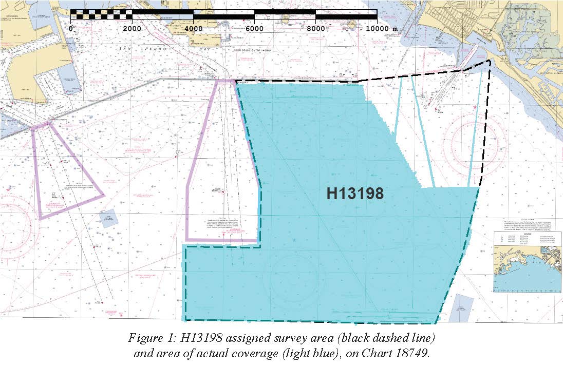
H13198: NOS Hydrographic Survey , 2018-10-29
National Oceanic and Atmospheric Administration, Department of Commerce —
The National Oceanic and Atmospheric Administration (NOAA) has the statutory mandate to collect hydrographic data in support of nautical chart compilation for safe... -
Federal
H13197: NOS Hydrographic Survey , 2018-10-29
National Oceanic and Atmospheric Administration, Department of Commerce —
The National Oceanic and Atmospheric Administration (NOAA) has the statutory mandate to collect hydrographic data in support of nautical chart compilation for safe... -
Federal
California spiny lobster habitat suitability model for Channel Islands National Marine Sanctuary Biogeographic Assessment
National Oceanic and Atmospheric Administration, Department of Commerce —
The National Marine Sanctuary Program (NMSP) updates and revises the management plans for each of its 13 sanctuaries. This process, which is open to the public,... -
Federal
Santa Monica, California 1/3 arc-second NAVD 88 Coastal Digital Elevation Model
National Oceanic and Atmospheric Administration, Department of Commerce —
NOAA's National Geophysical Data Center (NGDC) is building high-resolution digital elevation models (DEMs) for select U.S. coastal regions. These integrated... -
Federal
Southern California Hook and Line Survey - 2020 Southern California Shelf Rockfish Hook and Line Survey
National Oceanic and Atmospheric Administration, Department of Commerce —
The Fisheries Research Survey team proposes to conduct the annual Shelf Rockfish Hook and Line Survey during September-October 2020. The survey is an ongoing... -
Federal
San Diego, California 1/3 Arc-second NAVD 88 Coastal Digital Elevation Model
National Oceanic and Atmospheric Administration, Department of Commerce —
NOAA's National Geophysical Data Center (NGDC) is building high-resolution digital elevation models (DEMs) for select U.S. coastal regions. These integrated... -
Federal
Fish diversity in central and southern California using fish catch and effort data from the Recreational Fisheries Information Network
National Oceanic and Atmospheric Administration, Department of Commerce —
This dataset was provided by the Recreational Fisheries Information Network (RecFIN), and contained GPS coordinates for 680 CPFV trips during 1999 and 2001 at depths... -
Federal
Red sea urchin habitat suitability model for Channel Islands National Marine Sanctuary Biogeographic Assessment
National Oceanic and Atmospheric Administration, Department of Commerce —
The National Marine Sanctuary Program (NMSP) updates and revises the management plans for each of its 13 sanctuaries. This process, which is open to the public,... -
Federal
Purple sea urchin habitat suitability model for Channel Islands National Marine Sanctuary Biogeographic Assessment
National Oceanic and Atmospheric Administration, Department of Commerce —
The National Marine Sanctuary Program (NMSP) updates and revises the management plans for each of its 13 sanctuaries. This process, which is open to the public,... -
Federal
NOAA's Coastal Protection and Restoration Division: Watershed Database and Mapping Projects
National Oceanic and Atmospheric Administration, Department of Commerce —
Protection and restoration of coastal watersheds requires the synthesis of complex environmental issues. Contaminated site remediation, dredging and disposal of... -
Federal
Santa Monica, California 1/3 arc-second MHW Coastal Digital Elevation Model
National Oceanic and Atmospheric Administration, Department of Commerce —
NOAA's National Geophysical Data Center (NGDC) is building high-resolution digital elevation models (DEMs) for select U.S. coastal regions. These integrated... -
Federal
Hydrographic and CTD data from various platforms from the North Pacific Ocean from 1958-07-01 to 1983-03-08 (NCEI Accession 9000018)
National Oceanic and Atmospheric Administration, Department of Commerce —
This dataset contains Oregon State University Newport Line CTD data, and BT and Station Data provided by the California Department of Fish and Game. These data were... -
Federal
San Diego, California Tsunami Forecast Grids for MOST Model
National Oceanic and Atmospheric Administration, Department of Commerce —
The San Diego, California Forecast Model Grids provides bathymetric data strictly for tsunami inundation modeling with the Method of Splitting Tsunami (MOST) model.... -
Federal
Southern California Shelf Rockfish Hook and Line Survey (station)
National Oceanic and Atmospheric Administration, Department of Commerce —
This layer is intended to represent the geographic extent of NOAA Fisheriesâ Southern California Shelf Rockfish Hook and Line Survey. The Southern California Shelf... -
Federal
Data collected in the Southern California Bight in order to understand the coastal waters ecological systems, 1977 - 1999 (NCEI Accession 0001162)
National Oceanic and Atmospheric Administration, Department of Commerce —
Chemistry, fish species, atmospheric pollutants, and temperature profile were collected using CTD casts and other collection methods in the Southern California Bight... -
Federal
Red abalone habitat suitability model for Channel Islands National Marine Sanctuary Biogeographic Assessment
National Oceanic and Atmospheric Administration, Department of Commerce —
The National Marine Sanctuary Program (NMSP) updates and revises the management plans for each of its 13 sanctuaries. This process, which is open to the public,... -
Federal
Fish assemblages in southern California using trawl data from the National Marine Fisheries Service
National Oceanic and Atmospheric Administration, Department of Commerce —
Fish benthic trawls were completed by the National Marine Fisheries Service Groundfish Survey Program (NMFS GSP). Data from 477 fishery independent trawls ranging... -
Federal
Pacific angel shark habitat suitability model for Channel Islands National Marine Sanctuary Biogeographic Assessment
National Oceanic and Atmospheric Administration, Department of Commerce —
The National Marine Sanctuary Program (NMSP) updates and revises the management plans for each of its 13 sanctuaries. This process, which is open to the public,... -
Federal
California sea cucumber habitat suitability model for Channel Islands National Marine Sanctuary Biogeographic Assessment
National Oceanic and Atmospheric Administration, Department of Commerce —
The Office of National Marine Sanctuary Program (ONMS) updates and revises the management plans for each of its 13 sanctuaries. This process, which is open to the...

Official websites use .gov
A
.gov website belongs to an official government
organization in the United States.
Secure .gov websites use HTTPS
A
lock (
) or https:// means you’ve safely connected to
the .gov website. Share sensitive information only on official,
secure websites.