
-
Federal
data.hrsa.gov (HRSA Data Warehouse) recent views
U.S. Department of Health & Human Services —
DATA.HRSA.GOV is the go-to source for data, dashboards, maps, reports, locators, APIs and downloadable data files on HRSA's public health programs, including: HRSA-... -
Federal
National Mine Map Repository Mine Locations recent views
Department of the Interior —
The National Mine Map Repository (NMMR) maintains point locations for mines appearing on maps within its archive. This dataset is intended to help connect the Office... -
Federal
NASA Disasters Mapping Portal recent views
National Aeronautics and Space Administration —
This entry does not contain data itself, it is for the website, the NASA Disasters Mapping Portal: https://maps.disasters.nasa.gov The Disasters Mapping Portal... -
Federal
Great Lakes Bathymetry recent views
National Oceanic and Atmospheric Administration, Department of Commerce —
Bathymetry of Lakes Michigan, Erie, Saint Clair, Ontario and Huron has been compiled as a component of a NOAA project to rescue Great Lakes lake floor geological and... -
Federal
Ag and Food Statistics: Charting the Essentials recent views
Department of Agriculture —
A collection of over 75 charts and maps presenting key statistics on the farm sector, food spending and prices, food security, rural communities, the interaction of... -
Federal
Frontier and Remote Area Codes recent views
Department of Agriculture —
Frontier and Remote Area (FAR) codes provide a statistically-based, nationally-consistent, and adjustable definition of territory in the U.S. characterized by low... -
Federal
Community Planning and Development (CPD) Maps System recent views
Department of Housing and Urban Development —
CPD Maps includes data on the locations of existing CDBG, HOME, public housing and other HUD-funded community assets, so that users can view past investments... -
Federal
GIBS Web Map Tile Service (WMTS) recent views
National Aeronautics and Space Administration —
The WMTS implementation standard provides a standards-based solution for serviing digital maps using predefined image tiles. Through the constructs of the... -
Federal
Legacy Management Geospatial Environmental Mapping System recent views
Department of Energy —
Geospatial Environmental Mapping System (GEMS) provides geospatial layers and access to dynamic mapping and environmental monitoring data for LM sites. Analytical... -
Federal
HHS COVID-19 Small Area Estimations Survey - Primary Vaccine Series - Wave 04 recent views
U.S. Department of Health & Human Services —
The goal of the Monthly Outcome Survey (MOS) Small Area Estimations (SAE) is to generate estimates of the proportions of adults, by county and month, who were in the... -
Federal
Landsat 2000 recent views
National Aeronautics and Space Administration —
Landsat.org, an affiliate of the Tropical Rain Forest Information Center (TRFIC), now hosts the Global Orthorectified Landsat Datasets for four epochs: 1970's MSS,... -
Federal
HHS COVID-19 Small Area Estimations Survey - Primary Vaccine Series - Wave 22 recent views
U.S. Department of Health & Human Services —
The goal of the Monthly Outcome Survey (MOS) Small Area Estimations (SAE) is to generate estimates of the proportions of adults, by county and month, who were in the... -
Federal
Foreclosure and Crime data for the District of Columbia and Miami-Dade County, Florida, 2003-2011 recent views
Department of Justice —
These data are part of NACJD's Fast Track Release and are distributed as they there received from the data depositor. The files have been zipped by NACJD for release,... -
Federal
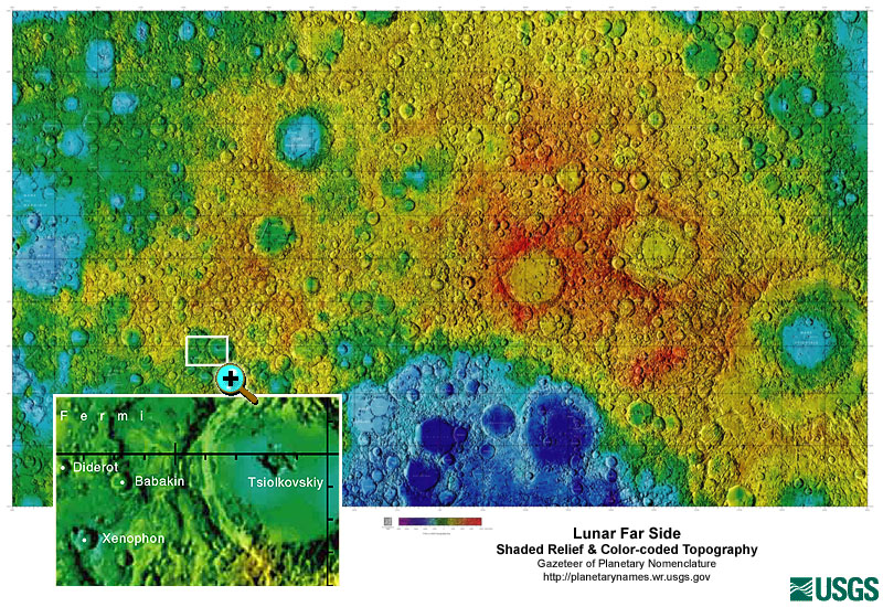
Gazetteer of Planetary Nomenclature: Moon: 1:10 million-scale Shaded Relief and Color-coded Topography: Far Side recent views
National Aeronautics and Space Administration —
These lunar maps display the four different areas of the moon with color-coded topography in low and high resolution approved by the International Astronomical Union... -
Federal
Charles M. Russell National Wildlife Refuge Fire History GIS Feature Classes recent views
Department of the Interior —
Summary This feature class documents the fire history on CMR from 1964 - present. This is 1 of 2 feature classes, a polygon and a point. This data has a variety of... -
Federal
PDS Planetary Maps API recent views
National Aeronautics and Space Administration —
We are developing a set of NASA Extensions to the Google Maps API—and soon to other frameworks such as OpenLayers as well—that will make these platforms more useful... -
Federal
HHS COVID-19 Small Area Estimations Survey - Primary Vaccine Series - Wave 13 recent views
U.S. Department of Health & Human Services —
The goal of the Monthly Outcome Survey (MOS) Small Area Estimations (SAE) is to generate estimates of the proportions of adults, by county and month, who were in the... -
Federal
HHS COVID-19 Small Area Estimations Survey - Updated Bivalent Vaccine Audience - Wave 26 recent views
U.S. Department of Health & Human Services —
The goal of the Monthly Outcome Survey (MOS) Small Area Estimations (SAE) is to generate estimates of the proportions of adults, by county and month, who were in the... -
Federal
HHS COVID-19 Small Area Estimations Survey - Updated Bivalent Vaccine Audience - Wave 25 recent views
U.S. Department of Health & Human Services —
The goal of the Monthly Outcome Survey (MOS) Small Area Estimations (SAE) is to generate estimates of the proportions of adults, by county and month, who were in the... -
Federal
HHS COVID-19 Small Area Estimations Survey - Primary Vaccine Series - Wave 16 recent views
U.S. Department of Health & Human Services —
The goal of the Monthly Outcome Survey (MOS) Small Area Estimations (SAE) is to generate estimates of the proportions of adults, by county and month, who were in the...

Official websites use .gov
A
.gov website belongs to an official government
organization in the United States.
Secure .gov websites use HTTPS
A
lock (
) or https:// means you’ve safely connected to
the .gov website. Share sensitive information only on official,
secure websites.