
-
Federal
First ISCCP Regional Experiment (FIRE) Atlantic Stratocumulus Transition Experiment (ASTEX) United Kingdom Meteorological Office (UKMO) C-130 Aircraft Data
National Aeronautics and Space Administration —
The First ISCCP Regional Experiments have been designed to improve data products and cloud/radiation parameterizations used in general circulation models (GCMs).... -
Federal
Sounder SIPS: AQUA AIRS IR + MW Level 2 CLIMCAPS: Cloud Cleared Radiances V2 at GES DISC
National Aeronautics and Space Administration —
The CLIMCAPS (Community Long-term Infrared Microwave Coupled Product System) algorithm is used to analyze data from the AIRS (Atmospheric Infrared Sounder) and AMSU... -
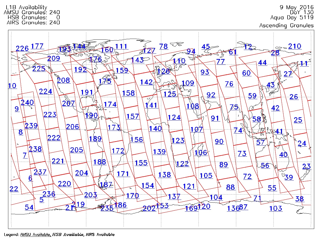
Federal
AIRS/Aqua Granule map product V005 (AIRXAMAP) at GES DISC
National Aeronautics and Space Administration —
The Atmospheric Infrared Sounder (AIRS) is a grating spectrometer (R = 1200) aboard the second Earth Observing System (EOS) polar-orbiting platform, EOS Aqua. In... -
Federal
MODIS/Aqua 8-Day Clear Sky Radiance Bias Daily L3 Global 1Deg Zonal Bands NGDA
National Aeronautics and Space Administration —
The MODIS/Aqua 8-Day Clear Sky Radiance Bias Daily L3 Global 1Deg Zonal Bands (MYDCSR_B) product consists of 1-degree zonal mean clear-sky biases (observed minus... -
Federal
Sounder SIPS: Suomi NPP CrIMSS Level 2 CHART Normal Spectral Resolution: Cloud Cleared Radiances V1
National Aeronautics and Space Administration —
The objective of this limited edition data collection is to examine products generated by the Climate Heritage AIRS Retrieval Technique (CHART) algorithm to analyze... -
Federal
SAFARI 2000 C-130 Aerosol and Meteorological Data, Dry Season 2000
National Aeronautics and Space Administration —
The Met Office C-130 research aircraft was based at Windhoek, Namibia, between September 5-16, 2000, where it conducted a series of flights over Namibia as part of... -
Federal
TRMM TROPICAL CYCLONE PRECIPITATION FEATURE (TCPF) DATABASE - LEVEL 1 V1
National Aeronautics and Space Administration —
The TRMM Cyclone Precipitation Feature (TCPF) Database - Level 1 provides Tropical Rainfall Measuring Mission (TRMM)-based tropical cyclone data in a common framework... -
Federal
Sounder SIPS: JPSS-1 CrIS Level 2 CLIMCAPS: Cloud Cleared Radiances V2 (SNDRJ1IML2CCPCCR) at GES DISC
National Aeronautics and Space Administration —
The CLIMCAPS (Community Long-term Infrared Microwave Coupled Product System) algorithm is used to analyze data from the Cross-track Infrared Sounder/Advanced... -
Federal
Sounder SIPS: AQUA AIRS IR-only Level 2 CLIMCAPS: Cloud Cleared Radiances V2 (SNDRAQIL2CCPCCR) at GES DISC
National Aeronautics and Space Administration —
WARNING: To users of the derived product “co_mmr_midtrop” (carbon monoxide mass mixing ratio to dry air [kg/kg] at ~500 hPa). This variable has a significant bias due... -
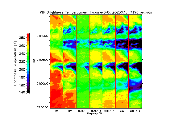
Federal
CAMEX-3 ER-2 Millimeter-wave Imaging Radiometer (MIR) V1
National Aeronautics and Space Administration —
The CAMEX-3 ER-2 Millimeter-wave Imaging Radiometer (MIR) dataset is a browse-only dataset containing plots of brightness temperature measurements collected by the... -
Federal
G-LiHT Hyperspectral Radiance V001
National Aeronautics and Space Administration —
Goddard’s LiDAR, Hyperspectral, and Thermal Imager (G-LiHT) mission is a portable, airborne imaging system that aims to simultaneously map the composition, structure,... -
Federal
G-LiHT Metrics V001
National Aeronautics and Space Administration —
Goddard’s LiDAR, Hyperspectral, and Thermal Imager (G-LiHT) mission is a portable, airborne imaging system that aims to simultaneously map the composition, structure,... -
Federal
G-LiHT Hyperspectral Vegetative Indices V001
National Aeronautics and Space Administration —
Goddard’s LiDAR, Hyperspectral, and Thermal Imager (G-LiHT) mission is a portable, airborne imaging system that aims to simultaneously map the composition, structure,... -
Federal
Tropical Ozone Transport Experiment – Vortex Ozone Transport Experiment (TOTE-VOTE) In Situ DC-8 Meteorology and Navigation Data
National Aeronautics and Space Administration —
TOTE-VOTE_MetNav_AircraftInSitu_DC8_Data_1 features the in situ meteorology and navigation data collected onboard the DC-8 aircraft during the Tropical Ozone... -
Federal
Meltpond2000 Polarimetric Scanning Radiometer Sea Ice Brightness Temperatures, Version 1
National Aeronautics and Space Administration —
The Meltpond2000 project was the first in a series of Arctic and Antarctic aircraft campaigns to validate sea ice algorithms developed for the Advanced Microwave... -
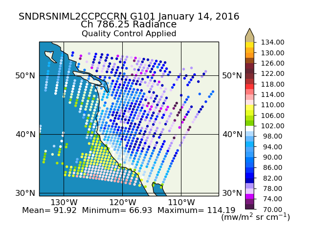
Federal
Sounder SIPS: Suomi NPP CrIMSS Level 2 CLIMCAPS Normal Spectral Resolution: Cloud Cleared Radiances V2 (SNDRSNIML2CCPCCRN) at GES DISC
National Aeronautics and Space Administration —
The CLIMCAPS (Community Long-term Infrared Microwave Coupled Product System) algorithm is used to analyze data from the Cross-track Infrared Sounder/Advanced... -
Federal
Sounder SIPS: Suomi NPP CrIMSS Level 2 CLIMCAPS Full Spectral Resolution: Cloud Cleared Radiances V2 at GES DISC
National Aeronautics and Space Administration —
The CLIMCAPS (Community Long-term Infrared Microwave Coupled Product System) algorithm is used to analyze data from the Cross-track Infrared Sounder/Advanced... -
Federal
SMEX02 Tower-Based Radiometric Surface Temperature, Walnut Creek, Iowa, Version 1
National Aeronautics and Space Administration —
This data set includes air temperature, vapor pressure, wind speed, and brightness temperatures taken at 12 flux towers as part of the Soil Moisture Experiment 2002... -
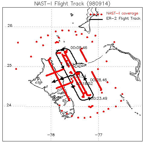
Federal
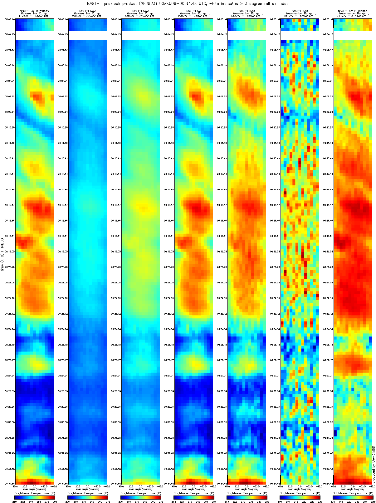
CAMEX-3 NAST-I RADIANCE PRODUCTS V1
National Aeronautics and Space Administration —
The National Polar-orbiting Operational Environmental Satellite System (NPOESS) Atmospheric Sounding Testbed (NAST) is a suite of airborne infrared and microwave...

Official websites use .gov
A
.gov website belongs to an official government
organization in the United States.
Secure .gov websites use HTTPS
A
lock (
) or https:// means you’ve safely connected to
the .gov website. Share sensitive information only on official,
secure websites.