
-
Federal
Delta-X: AirSWOT L2 Geocoded Water Surface Elevation, MRD, Louisiana, 2021, Version 2
National Aeronautics and Space Administration —
This dataset contains Level 2 (L2) AirSWOT geocoded products, including estimated water surface elevation. The AirSWOT instrument is a Ka-band interferometer and for... -
Federal
Primary Ancillary Data Geo-Colocated to OMI/Aura VIS 1-Orbit L2 Swath 13x24km V4 (OMVANC) at GES DISC
National Aeronautics and Space Administration —
The Primary Ancillary Data Geo-Colocated to OMI/Aura VIS 1-Orbit L2 Swath 13x24km (OMVANC) provides selected parameters from GEOS-5 Forward Processing for Instrument... -
Federal
Sentinel-1 Interferograms - Unwrapped Phase (BETA)
National Aeronautics and Space Administration —
Sentinel-1 SLC interferometric products generated by JPL using ISCE v2.0.0, delivered by ASF -
Federal
LBA-ECO LC-15 SRTM30 Digital Elevation Model Data, Amazon Basin: 2000
National Aeronautics and Space Administration —
This dataset provides a subset of the SRTM30 Digital Elevation Model (DEM) elevation and standard deviation data for the Amazon Basin. SRTM30 is a near-global digital... -
Federal
Global Forest Ecosystem Structure and Function Data For Carbon Balance Research
National Aeronautics and Space Administration —
A comprehensive global database has been assembled to quantify CO2 fluxes and pathways across different levels of integration (from photosynthesis up to net ecosystem... -
Federal
G-LiHT Digital Terrain Model V001
National Aeronautics and Space Administration —
Goddard’s LiDAR, Hyperspectral, and Thermal Imager (G-LiHT) mission (https://gliht.gsfc.nasa.gov/) utilizes a portable, airborne imaging system that aims to... -
Federal
CMS: LiDAR Data for Forested Areas in Paragominas, Para, Brazil, 2012-2014
National Aeronautics and Space Administration —
This data set provides raw LiDAR point cloud data and derived Digital Terrain Models (DTMs) for five forested areas in the municipality of Paragominas, Para, Brazil,... -
Federal
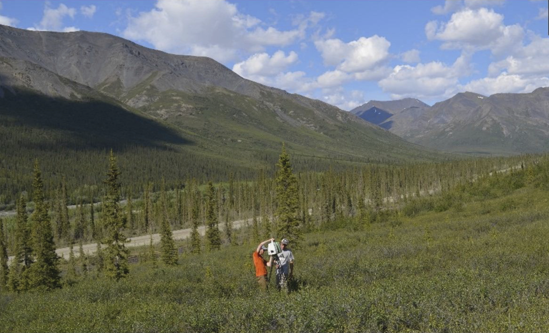
ABoVE: Terrestrial Lidar Scanning Forest-Tundra Ecotone, Brooks Range, Alaska, 2016
National Aeronautics and Space Administration —
This dataset provides terrestrial lidar scanning (TLS) point cloud data collected at 10 research plots along the forest-tundra ecotone (FTE) in the Brooks Range of... -
Federal
ABoVE: Synthesis of Burned and Unburned Forest Site Data, AK and Canada, 1983-2016
National Aeronautics and Space Administration —
This dataset is a synthesis of field plot characterization data, derived above-ground and below-ground combusted carbon, and acquired Fire Weather Index (FWI) System... -
Federal
Delta-X: UAVSAR L1 Single Look Complex (SLC) Stack Products, MRD, Louisiana, 2021
National Aeronautics and Space Administration —
This dataset contains UAVSAR Level 1 (L1) Single Look Complex (SLC) stack products for Delta-X flight lines acquired during 2021-03-27 to 2021-04-18 (spring) and... -
Federal
Arctic Circumpolar Distribution and Soil Carbon of Thermokarst Landscapes, 2015
National Aeronautics and Space Administration —
This data set provides the distribution of thermokarst landscapes in the boreal and tundra ecoregions within the northern circumpolar permafrost zones. This dataset... -
Federal
Arctic Vegetation Plots in Northern NWT and YT, Canada, 1965-1966
National Aeronautics and Space Administration —
This dataset provides vegetation, soil, and plot characteristics for 154 study plots located at three sites across the Richardson Mountains, Northwest Territories... -
Federal
G-LiHT Canopy Height Model KML V001
National Aeronautics and Space Administration —
Goddard’s LiDAR, Hyperspectral, and Thermal Imager (G-LiHT(https://gliht.gsfc.nasa.gov/)) mission utilizes a portable, airborne imaging system that aims to... -
Federal
LBA-ECO LC-03 Hypsography, Rivers, Roads, and DEM, Four Areas across Brazilian Amazon
National Aeronautics and Space Administration —
This data set provides four related spatial data products for four study areas across the Brazilian Amazon: Manaus, Amazonas; Tapajos National Forest, Para Western... -
Federal
Snake River Plain Geothermal Play Fairway Analysis Project Active Source Seismic Data
Department of Energy —
This archive contains seismic shot field records for 10 profiles located in Camas Prairie, Idaho. The eight numbered .sgy files were acquired using a seismic land... -
Federal
LBA-ECO ND-01 Watershed Deforestation from Landsat TM Series, Rondonia, Brazil: 1999
National Aeronautics and Space Administration —
This data set provides estimates of watershed deforestation, as a proportion of the total area of watersheds, in Rondonia, Brazil for 1999. Deforestation maps were... -
Federal
G-LiHT Aerial Orthomosaic V001
National Aeronautics and Space Administration —
Goddard’s LiDAR, Hyperspectral, and Thermal Imager (G-LiHT) mission is a portable, airborne imaging system that aims to simultaneously map the composition, structure,... -
Federal
CMS: LiDAR Data for Forested Sites on Borneo Island, Kalimantan, Indonesia, 2014
National Aeronautics and Space Administration —
This dataset provides airborne LiDAR data collected over 90 sites totaling approximately 100,000 hectares of forested land in Kalimantan, Indonesia on the island of... -
Federal
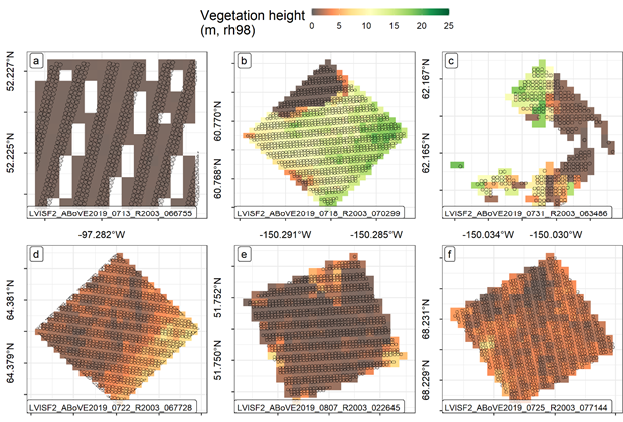
ABoVE: LVIS L3 Gridded Vegetation Structure across North America, 2017 and 2019
National Aeronautics and Space Administration —
This dataset provides Level 3 (L3) footprint-level gridded metrics and attributes collected from NASA's Land, Vegetation, and Ice Sensor (LVIS)-Facility instrument... -
Federal
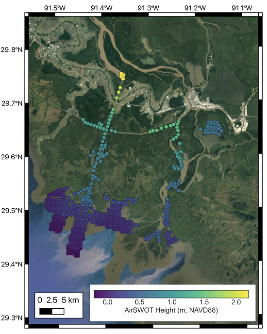
Delta-X: AirSWOT L3 Water Surface Elevations, MRD, Louisiana, 2021
National Aeronautics and Space Administration —
This dataset contains water surface elevations at selected point locations generated from the AirSWOT data collected during the Spring and Fall 2021 Delta-X...

Official websites use .gov
A
.gov website belongs to an official government
organization in the United States.
Secure .gov websites use HTTPS
A
lock (
) or https:// means you’ve safely connected to
the .gov website. Share sensitive information only on official,
secure websites.