
-
Federal
TRMM Ground Validation Calibrated QC Radar Reflectivity Full Volume Scan L1C 1 hour V7 (TRMM_1C51) at GES DISC
National Aeronautics and Space Administration —
The purpose of the 1C51 algorithm is to remove non-meteorological radar echoes that adversely affect the quality of higher level products, such as clutter associated... -
Federal
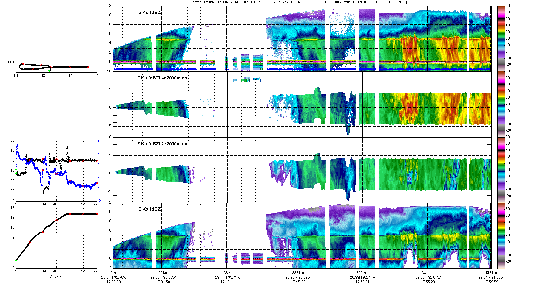
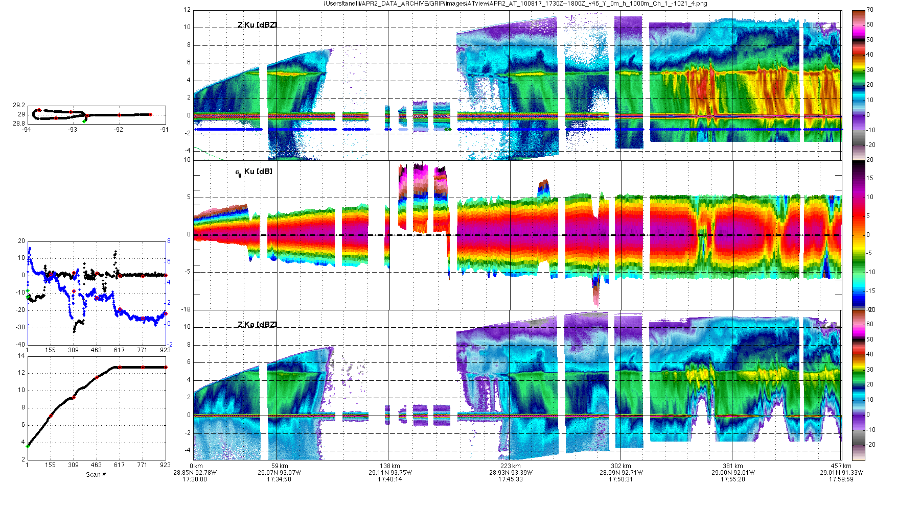
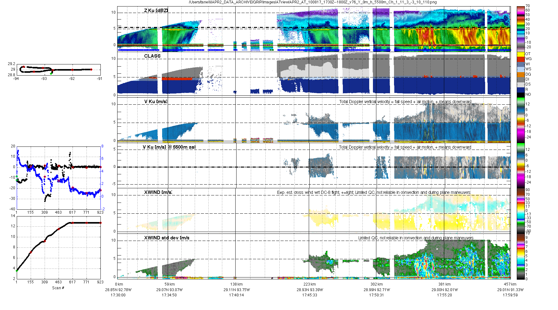
GPM GROUND VALIDATION AIRBORNE SECOND GENERATION PRECIPITATION RADAR (APR-2) GCPEX V1
National Aeronautics and Space Administration —
The GPM Ground Validation Airborne Second Generation Precipitation Radar (APR-2) GCPEx dataset was collected during the GPM Cold-season Precipitation Experiment... -
Federal
TRMM Ground Validation Rain Gauge Rain Rate L2 1 month V7 (TRMM_2A56) at GES DISC
National Aeronautics and Space Administration —
The program rgmin generates 1-minute hourly rain rates from discrete tipping bucket rain gauge data by applying an interpolation algorithm. The interpolating routine... -
Federal
TRMM Ground Validation Radar Site 3D Rain Map L3 1 month 2 km V7 (TRMM_3A55) at GES DISC
National Aeronautics and Space Administration —
The 3A55, 'Monthly 3-D Structure', provides radar site monthly 3-D structure information obtained from 2A55. The 2A55 'Radar Site 3-D Reflectivities', is composed of... -
Federal
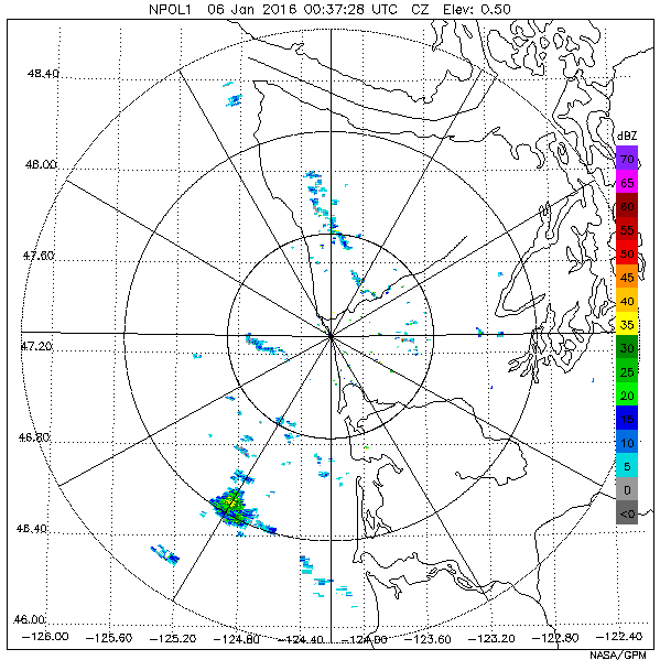
GPM Ground Validation NASA S-Band Dual Polarimetric (NPOL) Doppler Radar OLYMPEX V2
National Aeronautics and Space Administration —
The GPM Ground Validation NASA S-Band Dual Polarimetric (NPOL) Doppler Radar OLYMPEX V2 dataset consists of rain rate, reflectivity, Doppler velocity, and other radar... -
Federal
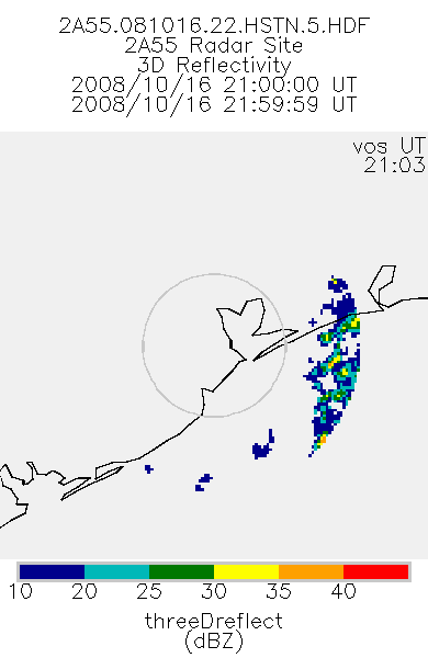
TRMM Ground Validation Radar Site 3D Reflectivity L2 1 hour V7 (TRMM_2A55) at GES DISC
National Aeronautics and Space Administration —
'Radar Site 3-D Reflectivities', is composed of 3 different fields. The first field has an array of 3-D reflectivities in Cartesian coordinates with a 2 km horizontal... -
Federal
GPM DPR Ku Precipitation Profile 2A 1.5 hours 5 km V07 (GPM_2AKu) at GES DISC
National Aeronautics and Space Administration —
Version 07 is the current version of the data set. Older versions will no longer be available and have been superseded by Version 07. The 2AKu algorithm is a single-... -
Federal
TRMM Ground Validation Rain Existence L2 1 month V7 (TRMM_2A52) at GES DISC
National Aeronautics and Space Administration —
The TRMM_2A52 product displays the existence of rain in the radar volume scan. 'Existence' is the fraction of the radar FOV which has measurable precipitation. The GV... -
Federal
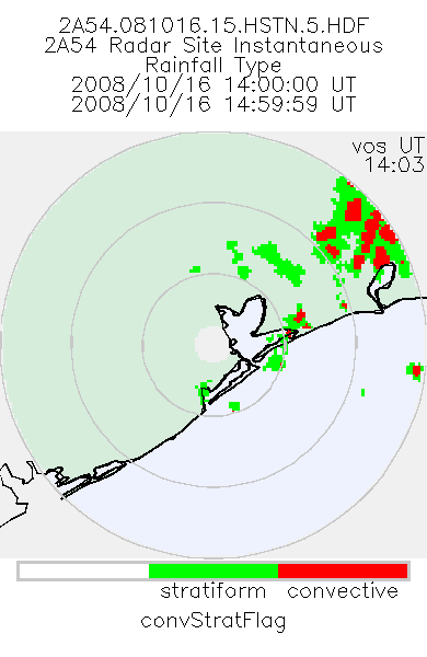
TRMM Ground Validation Radar Site Rain Type Map L2 1 hour 2 km V7 (TRMM_2A54) at GES DISC
National Aeronautics and Space Administration —
'Radar Site Convective/Stratiform Map', is an instantaneous map in Cartesian coordinates with a 2 km resolution. At single radar sites, the map covers an area of 300... -
Federal
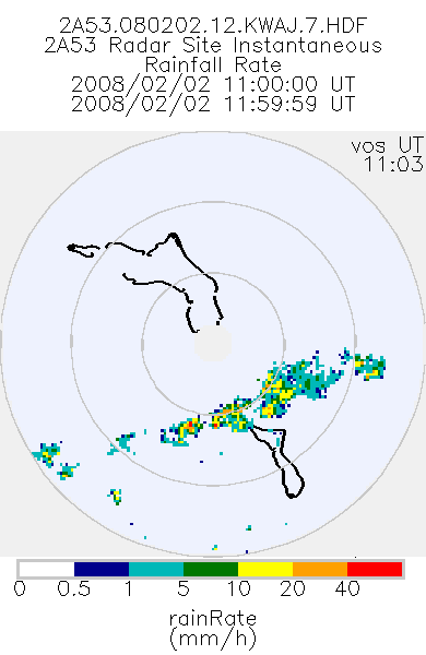
TRMM Ground Validation Radar Site Rain Rate Map L2 1 hour 2 km V7 (TRMM_2A53UW) at GES DISC
National Aeronautics and Space Administration —
This dataset is part of the University of Washington TRMM Ground Validation products. Instantaneous rain rate cartesian grid based on baseUW and 2A54UW. Units are... -
Federal
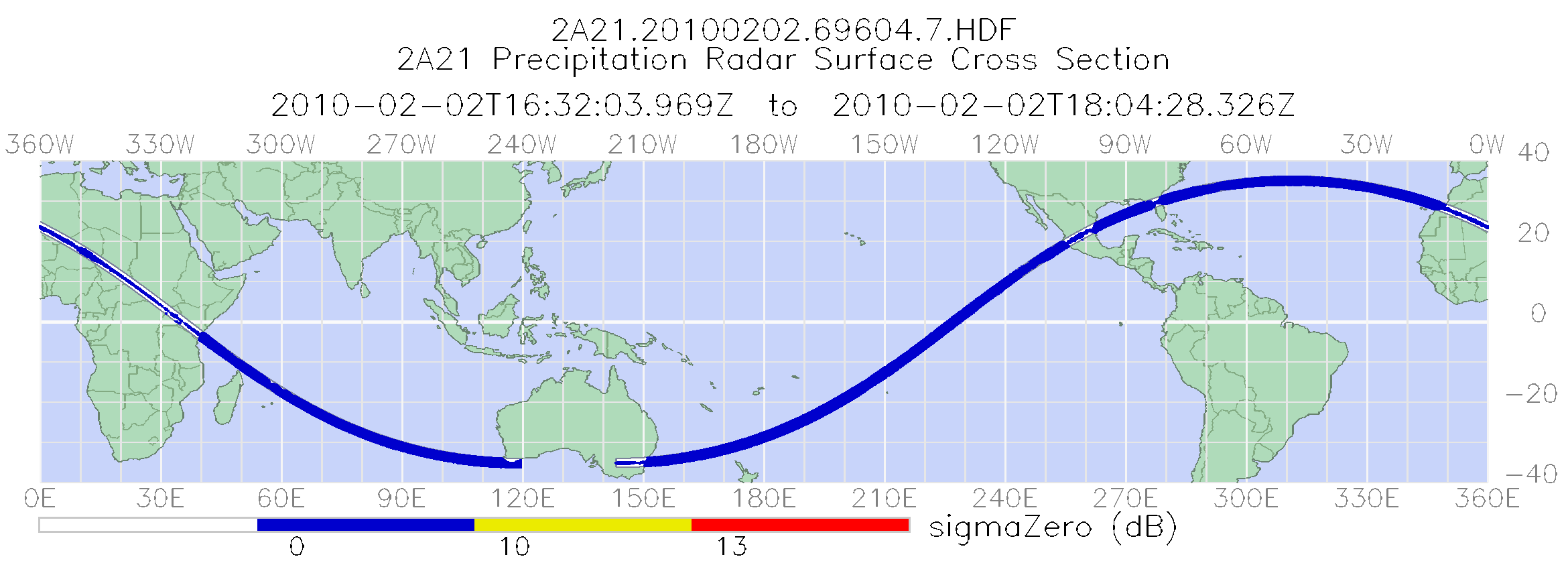
TRMM Precipitation Radar Surface Cross-Section L2 1.5 hours V7 (TRMM_2A21) at GES DISC
National Aeronautics and Space Administration —
The new version of these data is in GPM-like format (consistent with the GPM Dual-frequency Radar data format), and can be found under the name GPM_2APR. This is the... -
Federal
GPM Ground Validation Albert Head (AHD) Ground Meteorological Station (MET) OLYMPEX V1
National Aeronautics and Space Administration —
The GPM Ground Validation Albert Head (AHD) Ground Meteorological Station (MET) OLYMPEX dataset consists of precipitation rate, reflectivity, pressure, temperature,... -
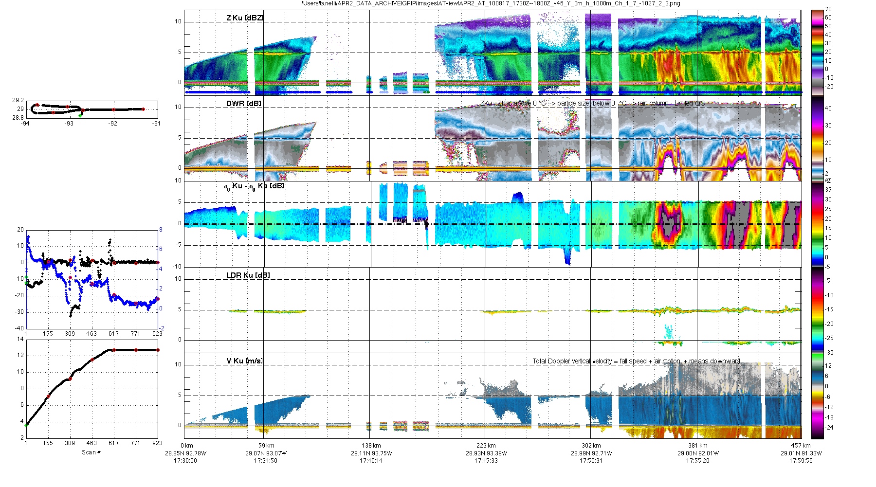
Federal
GRIP AIRBORNE SECOND GENERATION PRECIPITATION RADAR (APR-2) V1
National Aeronautics and Space Administration —
The GRIP Airborne Second Generation Precipitation Radar (APR-2) dataset was collected from the Second Generation Airborne Precipitation Radar (APR-2), which is a... -
Federal
GPM DPR Ka Precipitation Profile 2A 1.5 hours 5 km V07 (GPM_2AKa) at GES DISC
National Aeronautics and Space Administration —
Version 07 is the current version of the data set. Older versions will no longer be available and have been superseded by Version 07. The 2AKa algorithm provides... -
Federal
TRMM Radar Rainfall Statistics L3 1 month (5 x 5) and (0.5 x 0.5) degree V7 (TRMM_3A25) at GES DISC
National Aeronautics and Space Administration —
The new version of these data is in GPM-like format (consistent with the GPM Dual-frequency Radar data format), and can be found under the name GPM_3PR. This product... -
Federal
GPM DPR Precipitation Profile 1 month 0.25 degree x 0.25 degree V07 (GPM_3DPR) at GES DISC
National Aeronautics and Space Administration —
Version 07 is the current version of the data set. Older versions will no longer be available and have been superseded by Version 07. . The Level 3 DPR products... -
Federal
GPM Ground Validation TRMM 2A25 NRT Precipitation Radar IPHEx V7
National Aeronautics and Space Administration —
The GPM Ground Validation TRMM 2A25 NRT Precipitation Radar IPHEx data are estimates of instantaneous three-dimensional distribution of rain from the Tropical... -
Federal
GPM DPR Precipitation Profile 1 Day Ascending 0.25 degree x 0.25 degree V07 (GPM_3DPR_ASC) at GES DISC
National Aeronautics and Space Administration —
Version 07 is the current version of the data set. Older versions will no longer be available and have been superseded by Version 07. . The Level 3 DPR products... -
Federal
GPM GROUND VALIDATION NASA S-BAND DUAL POLARIMETRIC (NPOL) DOPPLER RADAR MC3E V1
National Aeronautics and Space Administration —
The GPM Ground Validation NASA S-band Dual Polarimetric (NPOL) Doppler Radar MC3E dataset was collected by the NASA NPOL radar, which was developed by a research team... -
Federal
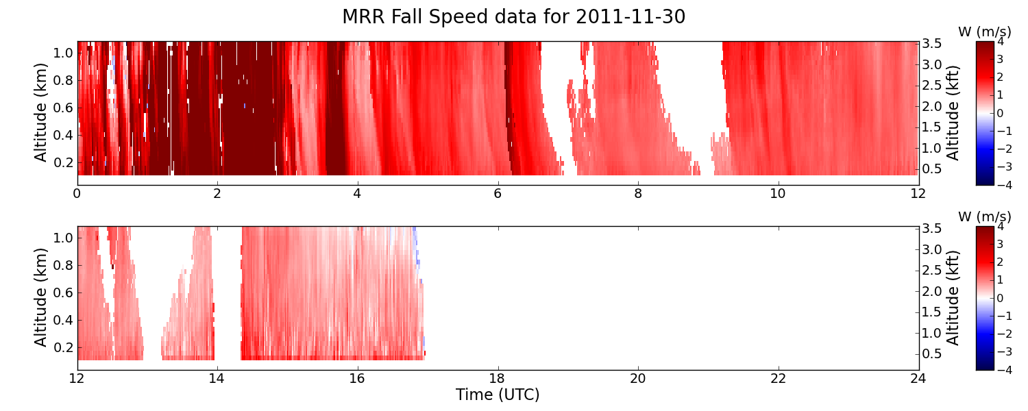
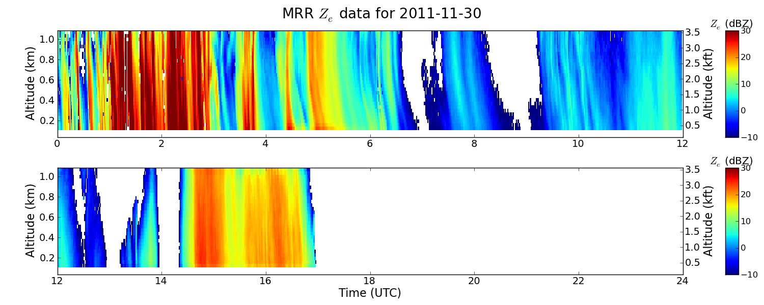
GPM GROUND VALIDATION NASA MICRO RAIN RADAR (MRR) GCPEX V2
National Aeronautics and Space Administration —
The GPM Ground Validation NASA Micro Rain Radar (MRR) GCPEx dataset was collected by a Micro Rain Radar (MRR), which is a vertically pointing Doppler radar which...

Official websites use .gov
A
.gov website belongs to an official government
organization in the United States.
Secure .gov websites use HTTPS
A
lock (
) or https:// means you’ve safely connected to
the .gov website. Share sensitive information only on official,
secure websites.