

TRMM Ground Validation Radar Site 3D Reflectivity L2 1 hour V7 (TRMM_2A55) at GES DISC
Access & Use Information
Public: This dataset is intended for public access and use.
License: No license information was provided. If this work was prepared by an officer or employee of the United States government as part of that person's official duties it is considered a U.S. Government Work.
Downloads & Resources
-
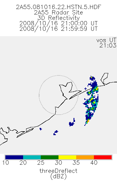
Get a related visualizationPNG
2A55_BR.081016.22.HSTN.5.PNG
-
This dataset's landing pageHTML
Access the dataset landing page from the GES DISC website.
-
Download this dataset through a directory mapHTML
Access the data via HTTPS
-
Download this dataset through Earthdata SearchHTML
Use the Earthdata Search to find and retrieve data sets across multiple data...
-
The dataset's project home pageHTML
TRMM Project Home Page
-
View the primary investigator's documentation...PDF
File specification document
-
The dataset's project home pageHTML
TRMM Field Campaign Project Page
-
View this dataset's algorithm theoretical...HTML
ALGORITHM THEORETICAL BASIS DOCUMENT (ATBD)
-
View documentation related to this datasetHTML
TRMM Data Gaps
-
Landing PageLanding Page
Dates
| Metadata Created Date | November 12, 2020 |
|---|---|
| Metadata Updated Date | April 11, 2025 |
Metadata Source
- Data.json Data.json Metadata
Harvested from NASA Data.json
Additional Metadata
| Resource Type | Dataset |
|---|---|
| Metadata Created Date | November 12, 2020 |
| Metadata Updated Date | April 11, 2025 |
| Publisher | NASA/GSFC/SED/ESD/GCDC/GESDISC |
| Maintainer | |
| Identifier | C1332654098-GES_DISC |
| Data First Published | 2011-07-01 |
| Language | en-US |
| Data Last Modified | 2025-03-31 |
| Category | TRMM, geospatial |
| Public Access Level | public |
| Bureau Code | 026:00 |
| Metadata Context | https://project-open-data.cio.gov/v1.1/schema/catalog.jsonld |
| Schema Version | https://project-open-data.cio.gov/v1.1/schema |
| Catalog Describedby | https://project-open-data.cio.gov/v1.1/schema/catalog.json |
| Harvest Object Id | 679ccf18-1777-42dd-b5a2-0cbdfc342cd1 |
| Harvest Source Id | 58f92550-7a01-4f00-b1b2-8dc953bd598f |
| Harvest Source Title | NASA Data.json |
| Homepage URL | https://cmr.earthdata.nasa.gov:443/search/concepts/C1332654098-GES_DISC.html |
| Metadata Type | geospatial |
| Old Spatial | -180.0 -40.0 180.0 40.0 |
| Program Code | 026:001 |
| Source Datajson Identifier | True |
| Source Hash | 99e3d13a42261cff05fb9d9d6f14d3edc0a16f852708a8a177240df412275310 |
| Source Schema Version | 1.1 |
| Spatial | |
| Temporal | 1997-11-27T00:00:00Z/2014-12-31T23:59:59.999Z |
Didn't find what you're looking for? Suggest a dataset here.