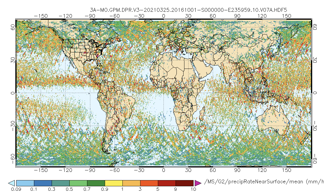
GPM DPR Precipitation Profile 1 month 0.25 degree x 0.25 degree V07 (GPM_3DPR) at GES DISC
Access & Use Information
Downloads & Resources
-
Google Scholar search resultsHTML
Search results for publications that cite this dataset by its DOI.
-
Get a related visualizationPNG
GPM_3DPR_07.png
-
This dataset's landing pageHTML
Access the dataset landing page from the GES DISC website.
-
Download this dataset through a directory mapHTML
Access the data via HTTPS
-
Use OPeNDAP to access the dataset's dataHTML
Access the data via the OPeNDAP protocol.
-
Download this dataset through Earthdata SearchHTML
Use the Earthdata Search to find and retrieve data sets across multiple data...
-
The dataset's project home pageHTML
GPM Project Home Page
-
View this dataset's algorithm theoretical...PDF
ATBD_DPR_L3_V7.pdf
-
View this dataset's read me documentPDF
README Document
-
View documentation related to this datasetPDF
FILE SPECIFICATION DOCUMENT
-
View documentation related to this datasetHTML
Instrument Description
-
View this dataset's documented anomaliesHTML
GPM and partner sensors anomalous events
-
Landing PageLanding Page
Dates
| Metadata Created Date | December 1, 2022 |
|---|---|
| Metadata Updated Date | December 6, 2023 |
Metadata Source
- Data.json Data.json Metadata
Harvested from NASA Data.json
Graphic Preview

Additional Metadata
| Resource Type | Dataset |
|---|---|
| Metadata Created Date | December 1, 2022 |
| Metadata Updated Date | December 6, 2023 |
| Publisher | NASA/GSFC/SED/ESD/GCDC/GESDISC |
| Maintainer | |
| Identifier | C2179081580-GES_DISC |
| Data First Published | 2021-12-06 |
| Language | en-US |
| Data Last Modified | 2021-12-06 |
| Category | GPM, geospatial |
| Public Access Level | public |
| Bureau Code | 026:00 |
| Metadata Context | https://project-open-data.cio.gov/v1.1/schema/catalog.jsonld |
| Metadata Catalog ID | https://data.nasa.gov/data.json |
| Schema Version | https://project-open-data.cio.gov/v1.1/schema |
| Catalog Describedby | https://project-open-data.cio.gov/v1.1/schema/catalog.json |
| Citation | Toshio Iguchi, Robert Meneghini. 2021-12-10. GPM_3DPR. Version 07. GPM DPR Precipitation Profile 1 month 0.25 degree x 0.25 degree V07. Greenbelt, MD. Archived by National Aeronautics and Space Administration, U.S. Government, Goddard Earth Sciences Data and Information Services Center (GES DISC). https://doi.org/10.5067/GPM/DPR/3A-MONTH/07. https://disc.gsfc.nasa.gov/datacollection/GPM_3DPR_07.html. Digital Science Data. |
| Creator | Toshio Iguchi, Robert Meneghini |
| Data Presentation Form | Digital Science Data |
| Graphic Preview File | https://docserver.gesdisc.eosdis.nasa.gov/public/project/GPM/browse/GPM_3DPR_07.png |
| Harvest Object Id | 8b4e16b8-607c-44aa-99df-69f772982e09 |
| Harvest Source Id | 58f92550-7a01-4f00-b1b2-8dc953bd598f |
| Harvest Source Title | NASA Data.json |
| Homepage URL | https://doi.org/10.5067/GPM/DPR/3A-MONTH/07 |
| Metadata Type | geospatial |
| Old Spatial | -180.0 -67.0 180.0 67.0 |
| Program Code | 026:001 |
| Release Place | Greenbelt, MD |
| Series Name | GPM_3DPR |
| Source Datajson Identifier | True |
| Source Hash | d2c9c3f94fa5fc2a5480328f178db514d6f68f1f27f4efec9a146b1557bab52a |
| Source Schema Version | 1.1 |
| Spatial | |
| Temporal | 2014-03-09T00:00:00Z/2023-02-28T00:00:00Z |
Didn't find what you're looking for? Suggest a dataset here.

