
-
Federal
Primary Ancillary Data Geo-Colocated to OMI/Aura VIS 1-Orbit L2 Swath 13x24km V4 (OMVANC) at GES DISC recent views
National Aeronautics and Space Administration —
The Primary Ancillary Data Geo-Colocated to OMI/Aura VIS 1-Orbit L2 Swath 13x24km (OMVANC) provides selected parameters from GEOS-5 Forward Processing for Instrument... -
Federal
ABoVE: Annual Thaw Slump Expansion on East Fork Chandalar River, Alaska, 2008-2017 recent views
National Aeronautics and Space Administration —
This dataset provides a time series of spatial data showing the expansion of a thaw slump on the East Fork Chandalar River near the community of Venetie, Alaska, from... -
Federal
NCA-LDAS Noah-3.3 Land Surface Model L4 Daily 0.125 x 0.125 degree V2.0 (NCALDAS_NOAH0125_D) at GES DISC recent views
National Aeronautics and Space Administration —
The National Climate Assessment - Land Data Assimilation System, or NCA-LDAS, is a terrestrial water reanalysis in support of the United States Global Change Research... -
Federal
MERRA-2 tavg1_2d_flx_Nx: 2d,1-Hourly,Time-Averaged,Single-Level,Assimilation,Surface Flux Diagnostics 0.625 x 0.5 degree V5.12.4 (M2T1NXFLX) at GES DISC recent views
National Aeronautics and Space Administration —
M2T1NXFLX (or tavg1_2d_flx_Nx) is an hourly time-averaged 2-dimensional data collection in Modern-Era Retrospective analysis for Research and Applications version 2... -
Federal
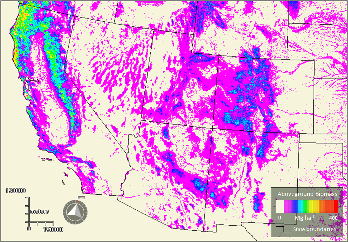
Forest Aboveground Biomass for the Southwestern U.S. from MISR, 2000-2021 recent views
National Aeronautics and Space Administration —
This dataset provides estimates of forest aboveground biomass (AGB; in Mg ha-1) at a resolution of 250 m for the southwestern United States over the time period... -
Federal
OPERA Radiometric Terrain Corrected SAR Backscatter from Sentinel-1 Static Layers validated product (Version 1) recent views
National Aeronautics and Space Administration —
The Observational Products for End-Users from Remote Sensing Analysis (OPERA) Radiometric Terrain Corrected (RTC) SAR Backscatter from Sentinel-1 (S1) Static Layers... -
Federal
ISLSCP II ECMWF Near-Surface Meteorology Parameters recent views
National Aeronautics and Space Administration —
This data set for the ISLSCP Initiative II data collection provides meteorology data with fixed, monthly, monthly-6-hourly, 6-hourly, and 3-hourly temporal... -
Federal
Pre-ABoVE: Remotely Sensed Active Layer Thickness, Barrow, Alaska, 2006-2011 recent views
National Aeronautics and Space Administration —
Active layer thickness (ALT) is a critical parameter for monitoring the status of permafrost that is typically measured at specific locations using probing, in situ... -
Federal
Pre-ABoVE: Remotely Sensed Active Layer Thickness, Prudhoe Bay, Alaska, 1992-2000 recent views
National Aeronautics and Space Administration —
Active layer thickness (ALT) is a critical parameter for monitoring the status of permafrost that is typically measured at specific locations using probing, in situ... -
Federal
Pre-ABoVE: Ground-penetrating Radar Measurements of ALT on the Alaska North Slope recent views
National Aeronautics and Space Administration —
This data set includes estimates of permafrost Active Layer Thickness (ALT; cm), and calculated uncertainties, derived using a ground-penetrating radar (GPR) system... -
Federal
ABoVE: Active Layer Thickness from Remote Sensing Permafrost Model, Alaska, 2001-2015 NGDA recent views
National Aeronautics and Space Administration —
This dataset provides annual estimates of active layer thickness (ALT) at 1 km resolution across Alaska from 2001-2015. The ALT was estimated using a remote sensing-... -
Federal
ABoVE: Permafrost Measurements and Distribution Across the Y-K Delta, Alaska, 2016 recent views
National Aeronautics and Space Administration —
This dataset provides field observations of thaw depth and dominant vegetation types, a LiDAR-derived elevation map, and permafrost distribution and probability maps... -
Federal
ABoVE: Active Layer Thickness from Airborne L- and P- band SAR, Alaska, 2017, Ver. 3 recent views
National Aeronautics and Space Administration —
This dataset provides estimates of seasonal subsidence, active layer thickness (ALT), the vertical soil moisture profile, and uncertainties at a 30 m resolution for... -
Federal
OPERA Coregistered Single-Look Complex from Sentinel-1 Static Layers validated product (Version 1) recent views
National Aeronautics and Space Administration —
The Observational Products for End-Users from Remote Sensing Analysis (OPERA) Coregistered Single-Look Complex (CSLC) from Sentinel-1 (S1) Static Layers... -
Federal
ABoVE: CO2 and CH4 Fluxes and Meteorology at Flux Tower Sites, Alaska, 2015-2017 recent views
National Aeronautics and Space Administration —
This dataset provides CO2 and CH4 fluxes and meteorological parameters from five eddy covariance (EC) tower sites located at Barrow (three sites), Atqasuk (ATQ) and... -
Federal
OPERA Radiometric Terrain Corrected SAR Backscatter from Sentinel-1 validated product (Version 1) recent views
National Aeronautics and Space Administration —
The Observational Products for End-Users from Remote Sensing Analysis (OPERA) Radiometric Terrain Corrected (RTC) SAR Backscatter from Sentinel-1 (S1) validated... -
Federal
ISLSCP II Northern Hemisphere Monthly Snow Cover Extent recent views
National Aeronautics and Space Administration —
This ISLSCP data set is derived from the National Snow and Ice Data Center (NSIDC) Northern Hemisphere EASE-Grid Weekly Snow Cover and Sea Ice Extent product which... -
Federal
BOREAS RSS-08 BIOME-BGC Model Simulations at Tower Flux Sites in 1994 recent views
National Aeronautics and Space Administration —
BIOME-BGC is a general ecosystem process model designed to simulate biogeochemical and hydrologic processes across multiple scales. BIOME-BGC is used to estimate... -
Federal
BOREAS Derived Surface Meteorological Data recent views
National Aeronautics and Space Administration —
Contains surface meteorology data merged/interpolated from four BOREAS sites for the years 1994, 1995, and 1996. -
Federal
OPERA Radiometric Terrain Corrected SAR Backscatter from Sentinel-1 product for Calibration & Validation (Version 1) recent views
National Aeronautics and Space Administration —
This dataset contains the products used for calibration and validation of the Observational Products for End-Users from Remote Sensing Analysis (OPERA) Radiometric...

Official websites use .gov
A
.gov website belongs to an official government
organization in the United States.
Secure .gov websites use HTTPS
A
lock (
) or https:// means you’ve safely connected to
the .gov website. Share sensitive information only on official,
secure websites.