
-
Federal
NACP North American Forest Dynamics Project: Forest Disturbance and Regrowth Data recent views
National Aeronautics and Space Administration —
This data set provides the results of time-series analyses of Landsat imagery for 55 selected forested sites across the conterminous U.S.A. The output is a pair of... -
Federal
Global Monthly GPP from an Improved Light Use Efficiency Model, 1982-2016 recent views
National Aeronautics and Space Administration —
This dataset provides global monthly average gross primary productivity (GPP; g carbon/m2/d) modeled at 8 km spatial resolution for each of the 35 years from... -
Federal
VEMAP 2: Annual Ecosystem Model Responses to U.S. Climate Change, 1994-2100 recent views
National Aeronautics and Space Administration —
Phase 2 of the VEMAP Project developed historical (1895-1993) gridded data sets of climate (temperature, precipitation, solar radiation, humidity, and wind speed) and... -
Federal
Arctic Vegetation Plots for IBP Tundra Biome, Barrow, Alaska, 1972-2010 recent views
National Aeronautics and Space Administration —
This data set provides vegetation cover and environmental plot data collected as part of the International Biological Program (IBP), U. S. Tundra Biome Program, in... -
Federal
Arctic Vegetation Plots at Toolik Lake, Alaska, 1989 recent views
National Aeronautics and Space Administration —
This dataset provides environmental, soil, and vegetation data collected in August 1989 from 81 study plots at the Toolik Lake research site, located in the southern... -
Federal
ISLSCP II Historical Land Cover and Land Use, 1700-1990 NGDA recent views
National Aeronautics and Space Administration —
The Historical Land Cover and Land Use data set was developed to provide the global change community with historical land use estimates. The data set describes... -
Federal
Siberian Boreal Forest Aboveground Biomass and Fire Scar Maps, Russia, 1969-2007 NGDA recent views
National Aeronautics and Space Administration —
This data set provides 30-meter resolution mapped estimates of Cajander larch (Larix cajanderi) aboveground biomass (AGB), circa 2007, and a map of burn perimeters... -
Federal
Sentinel-1 Interferograms - Unwrapped Phase (BETA) recent views
National Aeronautics and Space Administration —
Sentinel-1 SLC interferometric products generated by JPL using ISCE v2.0.0, delivered by ASF -
Federal
NACP Forest Age Maps at 1-km Resolution for Canada (2004) and the U.S.A. (2006) recent views
National Aeronautics and Space Administration —
This data set provides forest age map products at 1-km resolution for Canada and the United States (U.S.A.). These continental forest age maps were compiled from... -
Federal
ISLSCP II Ecosystem Rooting Depths NGDA recent views
National Aeronautics and Space Administration —
The goal of this study was to predict the global distribution of plant rooting depths based on data about global aboveground vegetation structure and climate.... -
Federal
ABoVE: Ecosystem Map, Great Slave Lake Area, Northwest Territories, Canada, 1997-2011 recent views
National Aeronautics and Space Administration —
This dataset provides an ecosystem type map at 12.5 meter pixel spacing and 0.2 ha minimum mapping unit for the area surrounding Great Slave Lake, Northwest... -
Federal
ABoVE: Peak Greenness for Canadian Boreal Forest from Landsat 5 TM Imagery, 1984-2011 recent views
National Aeronautics and Space Administration —
This dataset provides a 28-year time series of peak greenness (NDVI) data derived from Landsat 5 TM imagery over the boreal forest region of Canada. Landsat 5 TM... -
Federal
Urban Biogenic CO2 fluxes: GPP, Reco and NEE Estimates from SMUrF, 2010-2019 NGDA recent views
National Aeronautics and Space Administration —
This dataset contains estimates of biogenic CO2 flux components at 0.05 degree resolution from the Solar-Induced Fluorescence (SIF) for Modeling Urban biogenic Fluxes... -
Federal
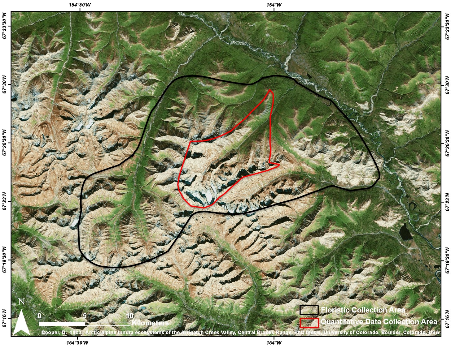
Arctic Vegetation Plots at Arrigetch Peaks, Alaska, 1978-1981 recent views
National Aeronautics and Space Administration —
This data set provides environmental and vegetation data collected between 1978 and 1981 from 439 study plots at Arrigetch Peaks research site, located in the Gates... -
Federal
High Resolution Land Cover-Specific Solar-Induced Fluorescence, Midwestern USA, 2018 NGDA recent views
National Aeronautics and Space Administration —
This dataset provides estimated solar-induced chlorophyll fluorescence (SIF) of specific vegetation types and total SIF under clear-sky and real/cloudy conditions at... -
Federal
Arctic Vegetation Plots Legacy Project Barter Island and Point Barrow, Alaska, 1994 recent views
National Aeronautics and Space Administration —
This dataset provides vegetation cover and environmental plot and soil data collected at two U.S. Air Force sites at Barter Island (BI) and Point Barrow (B), on the... -
Federal
Arctic Vegetation Plots at Happy Valley, Alaska, 1994 recent views
National Aeronautics and Space Administration —
This dataset provides environmental, soil, and vegetation data collected in July 1994 from 56 study plots at the Happy Valley research site, located along the... -
Federal
SAFARI 2000 Potential Vegetation, 5-min (Ramankutty and Foley) recent views
National Aeronautics and Space Administration —
This data set consists of a southern African subset of the 5-min resolution Global Potential Vegetation data set developed by Navin Ramankutty and Jon Foley at the... -
Federal
ISLSCP II University of Maryland Global Land Cover Classifications, 1992-1993 recent views
National Aeronautics and Space Administration —
The objective of the International Satellite Land Surface Climatology Project (ISLSCP II) study that produced this data set, ISLSCP II University of Maryland Global... -
Federal
Global Soil Profile Data (ISRIC-WISE) recent views
National Aeronautics and Space Administration —
The ISRIC-WISE International soil profile data set consists of a homogenized, global set of 1,125 soil profiles for use by global modelers. These profiles provided...

Official websites use .gov
A
.gov website belongs to an official government
organization in the United States.
Secure .gov websites use HTTPS
A
lock (
) or https:// means you’ve safely connected to
the .gov website. Share sensitive information only on official,
secure websites.