ABoVE: Peak Greenness for Canadian Boreal Forest from Landsat 5 TM Imagery, 1984-2011
Access & Use Information
Downloads & Resources
-
Google Scholar search resultsHTML
Search results for publications that cite this dataset by its DOI.
-
Download this datasetHTML
This link allows direct data access via Earthdata login
-
View documentation related to this datasetHTML
ORNL DAAC Data Set Documentation
-
This dataset's landing pageHTML
Data set Landing Page DOI URL
-
View documentation related to this datasetPDF
ABoVE: Satellite Observations of Peak Greenness for Canadian Boreal Forest,...
-
Get a related visualizationPNG
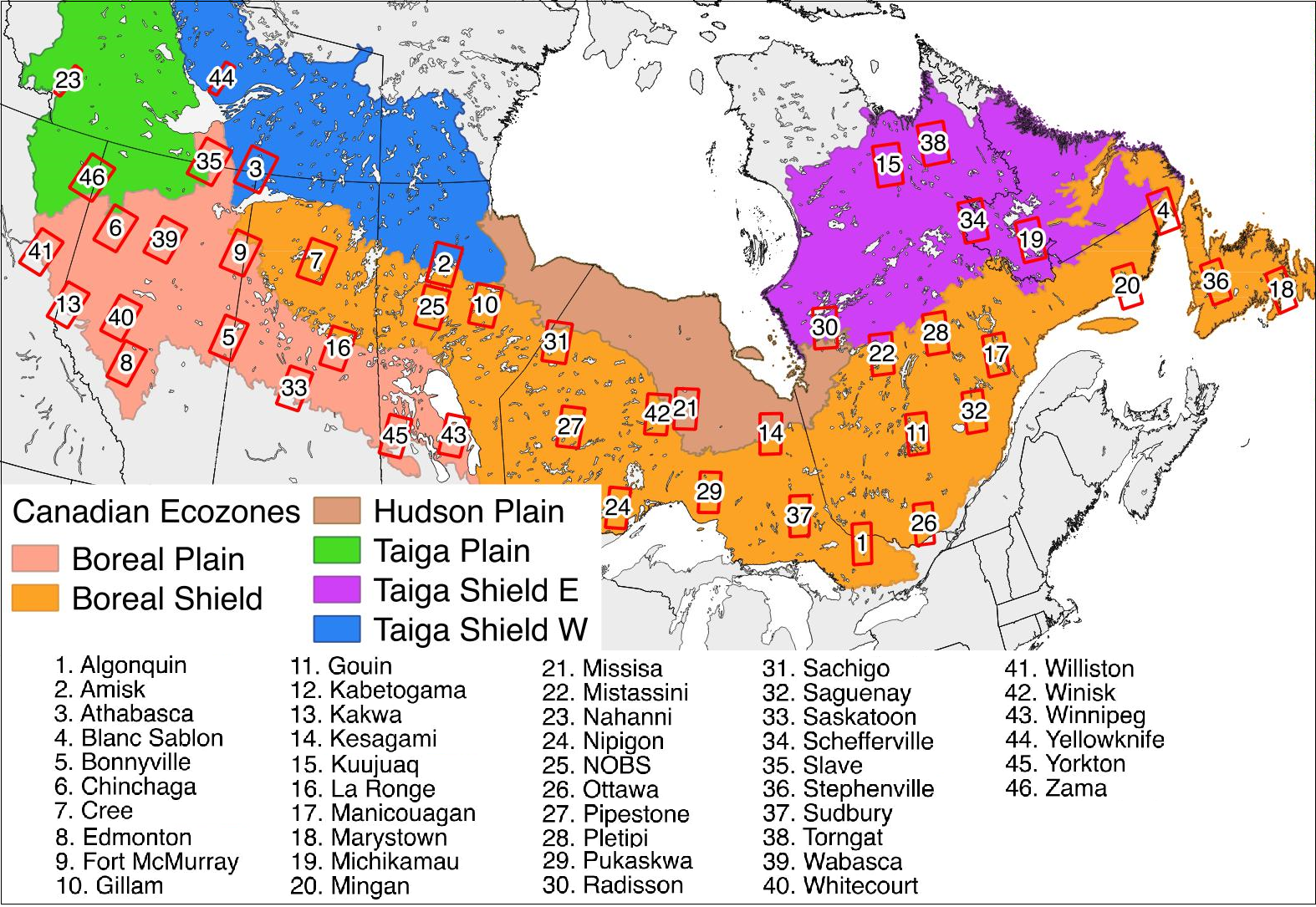
The Canadian boreal forest study area and the 46 sites used in the analyses...
-
The dataset's project home pageHTML
ABoVE project site
-
Landing PageLanding Page
Dates
| Metadata Created Date | December 1, 2022 |
|---|---|
| Metadata Updated Date | December 7, 2023 |
Metadata Source
- Data.json Data.json Metadata
Harvested from NASA Data.json
Graphic Preview

Additional Metadata
| Resource Type | Dataset |
|---|---|
| Metadata Created Date | December 1, 2022 |
| Metadata Updated Date | December 7, 2023 |
| Publisher | ORNL_DAAC |
| Maintainer | |
| Identifier | C2162140027-ORNL_CLOUD |
| Data First Published | 2018-05-15 |
| Language | en-US |
| Data Last Modified | 2023-06-12 |
| Category | ABoVE, geospatial |
| Public Access Level | public |
| Bureau Code | 026:00 |
| Metadata Context | https://project-open-data.cio.gov/v1.1/schema/catalog.jsonld |
| Metadata Catalog ID | https://data.nasa.gov/data.json |
| Schema Version | https://project-open-data.cio.gov/v1.1/schema |
| Catalog Describedby | https://project-open-data.cio.gov/v1.1/schema/catalog.json |
| Citation | Sulla-Menashe, D., M.A. Friedl, C. Woodcock, and E.K. Melaas. 2018. ABoVE: Peak Greenness for Canadian Boreal Forest from Landsat 5 TM Imagery, 1984-2011. ORNL DAAC, Oak Ridge, Tennessee, USA. https://doi.org/10.3334/ORNLDAAC/1587 |
| Graphic Preview Description | The Canadian boreal forest study area and the 46 sites used in the analyses (identified by red boxes) mapped on top of: (A) ecozones (from http://canadianbiodiversity.mcgill.ca/english/ecozones/index.htm), (B) AVHRR NDVI trends (Beck and Goetz 2011), (C) tree cover from the MODIS VCF product (Hansen et al. 2003), and (D) fire disturbance from the Canadian Large Fire Database (Stocks et al. 2002). The sites were numbered in alphabetical order and site names are listed below the map. |
| Graphic Preview File | https://daac.ornl.gov/ABOVE/guides/Canada_Boreal_Forest_Greenness_Fig1.png |
| Harvest Object Id | 0e0f9ab2-1210-4ff9-ae3f-22f548c79829 |
| Harvest Source Id | 58f92550-7a01-4f00-b1b2-8dc953bd598f |
| Harvest Source Title | NASA Data.json |
| Homepage URL | https://doi.org/10.3334/ORNLDAAC/1587 |
| Metadata Type | geospatial |
| Old Spatial | -124.47 45.32 -53.91 63.44 |
| Program Code | 026:001 |
| Source Datajson Identifier | True |
| Source Hash | 616b450cbf54ea236a6959e9bfc9b4d4e9f5780082c5e9d229cd4cf22f4ccf93 |
| Source Schema Version | 1.1 |
| Spatial | |
| Temporal | 1970-01-01T00:00:00Z/2014-12-31T23:59:59Z |
Didn't find what you're looking for? Suggest a dataset here.

