
-
Federal
Winyah Bay, SC (S060) Bathymetric Digital Elevation Model (30 meter resolution) Derived From Source Hydrographic Survey Soundings Collected by NOAA
National Oceanic and Atmospheric Administration, Department of Commerce —
Bathymetry for Winyah Bay was derived from eight surveys containing 33,974 soundings. No surveys were omitted. The average separation between soundings was 49 meters.... -
Federal
Near-real-time surface ocean velocities derived from HF-radar stations located along coastal waters of North Slope Alaska, Gulf of Alaska, Puerto Rico/Virgin Islands, eastern U.S./Gulf of America, Hawaii, Great Lakes, and western U.S.
National Oceanic and Atmospheric Administration, Department of Commerce —
This dataset contains near-real-time ocean surface velocities, also known as total vector velocities, derived from high-frequency (HF) radar stations. The velocities... -
County
Airport Impact Overlay District
Loudoun County, Virginia —
The AIOD is administered by Loudoun County. The boundaries are based on the Loudness Day Night (LDN) noise contours that were updated by the Metropolitan Area... -
Federal
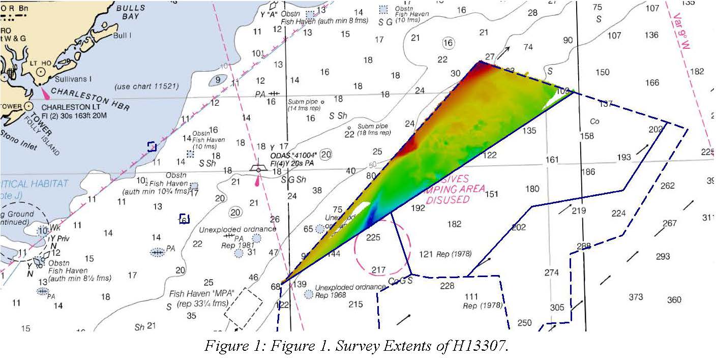
H13307: NOS Hydrographic Survey , 2019-08-30
National Oceanic and Atmospheric Administration, Department of Commerce —
The National Oceanic and Atmospheric Administration (NOAA) has the statutory mandate to collect hydrographic data in support of nautical chart compilation for safe... -
Federal
F00783: NOS Hydrographic Survey , 2019-08-13
National Oceanic and Atmospheric Administration, Department of Commerce —
The National Oceanic and Atmospheric Administration (NOAA) has the statutory mandate to collect hydrographic data in support of nautical chart compilation for safe... -
Federal
H06797: NOS Hydrographic Survey , 1943-03-04
National Oceanic and Atmospheric Administration, Department of Commerce —
The National Oceanic and Atmospheric Administration (NOAA) has the statutory mandate to collect hydrographic data in support of nautical chart compilation for safe... -
Federal
Deepwater Canyons 2012: Pathways to the Abyss on NOAA Ship Nancy Foster between 20120815 and 20121001
National Oceanic and Atmospheric Administration, Department of Commerce —
The Mid-Atlantic Deep-Water Canyons project is co-funded by the Bureau of Ocean Energy Management (BOEM) and NOAAâs Office of Ocean Exploration and Research (which... -
Federal
Broad River, SC (S110) Bathymetric Digital Elevation Model (30 meter resolution) Derived From Source Hydrographic Survey Soundings Collected by NOAA
National Oceanic and Atmospheric Administration, Department of Commerce —
Bathymetry for the Broad River was derived from twenty-three surveys containing 98,479 soundings. No surveys were omitted. The average separation between soundings... -
Federal
BLM ES Administrative Unit Office Arc
Department of the Interior —
This polyline feature class represents the spatial extent of active Bureau of Land Management (BLM) Administrative Unit Boundaries at the State, District, and Field... -
Federal
BLM ES Administrative Unit Office Points
Department of the Interior —
This feature-dataset depicts Bureau of Land Management (BLM) office locations. The land areas for higher level administrative units (district and administrative... -
Federal
AtlanticCanyons2011: Exploration and Research of Mid-Atlantic Deepwater hard Bottom Habitats and Shipwrecks with Emphasis on Canyons and Coral Communities between 20110604 and 20110617
National Oceanic and Atmospheric Administration, Department of Commerce —
This is an interagency study that focuses on the exploration and investigation of deepwater hard bottom biological communities located in the northwest Atlantic Ocean... -
Federal
H13987: NOS Hydrographic Survey , 2024-10-13
National Oceanic and Atmospheric Administration, Department of Commerce —
The National Oceanic and Atmospheric Administration (NOAA) has the statutory mandate to collect hydrographic data in support of nautical chart compilation for safe... -
Federal
CHIRP Subbottom Profiler Data for the US Atlantic Margin
National Oceanic and Atmospheric Administration, Department of Commerce —
Knudsen 3260 CHIRP subbottom profiler - CHIRP Subbottom Profiler data were collected in Raw Knudsen SEG-Y Datagram format. -
Federal
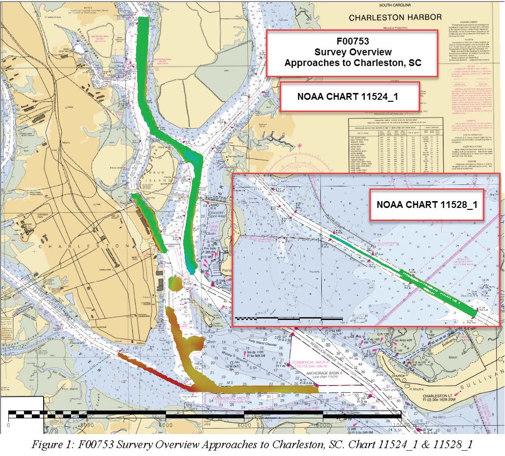
F00753: NOS Hydrographic Survey , 2018-10-23
National Oceanic and Atmospheric Administration, Department of Commerce —
The National Oceanic and Atmospheric Administration (NOAA) has the statutory mandate to collect hydrographic data in support of nautical chart compilation for safe... -
Federal
W00338: NOS Hydrographic Survey , 2014-07-20
National Oceanic and Atmospheric Administration, Department of Commerce —
The National Oceanic and Atmospheric Administration (NOAA) has the statutory mandate to collect hydrographic data in support of nautical chart compilation for safe... -
Federal
Santee River, SC (S070) Bathymetric Digital Elevation Model (30 meter resolution) Derived From Source Hydrographic Survey Soundings Collected by NOAA
National Oceanic and Atmospheric Administration, Department of Commerce —
Bathymetry for the Santee River was derived from two surveys containing 11,079 soundings. No surveys were omitted. The average separation between soundings was 40... -
Federal
St. Helena Sound, SC (S100) Bathymetric Digital Elevation Model (30 meter resolution) Derived From Source Hydrographic Survey Soundings Collected by NOAA
National Oceanic and Atmospheric Administration, Department of Commerce —
Bathymetry for St. Helena Sound was derived from nineteen surveys containing 83,246 soundings. No surveys were omitted. The average separation between soundings was... -
Federal
H13983: NOS Hydrographic Survey , 2024-10-13
National Oceanic and Atmospheric Administration, Department of Commerce —
The National Oceanic and Atmospheric Administration (NOAA) has the statutory mandate to collect hydrographic data in support of nautical chart compilation for safe... -
Federal
Surface ocean radial velocities obtained by HF-radar from stations located along coastal waters of Hawaii, North Slope Alaska, Gulf of Alaska, Puerto Rico/Virgin Islands, eastern U.S./Gulf of America, western U.S., and the Great Lakes
National Oceanic and Atmospheric Administration, Department of Commerce —
This dataset contains surface ocean radial velocities data obtained by HF-radar from stations located along coastal waters of the United States. Radial velocity files... -
Federal
H13980: NOS Hydrographic Survey , 2024-10-26
National Oceanic and Atmospheric Administration, Department of Commerce —
The National Oceanic and Atmospheric Administration (NOAA) has the statutory mandate to collect hydrographic data in support of nautical chart compilation for safe...

Official websites use .gov
A
.gov website belongs to an official government
organization in the United States.
Secure .gov websites use HTTPS
A
lock (
) or https:// means you’ve safely connected to
the .gov website. Share sensitive information only on official,
secure websites.