
-
Federal
Global Vegetation Greenness (NDVI) from AVHRR GIMMS-3G+, 1981-2022
National Aeronautics and Space Administration —
This dataset holds the Global Inventory Modeling and Mapping Studies-3rd Generation V1.2 (GIMMS-3G+) data for the Normalized Difference Vegetation Index (NDVI). NDVI... -
Federal
Snake River Plain FORGE: Site Characterization Data
Department of Energy —
The site characterization data used to develop the conceptual geologic model for the Snake River Plain site in Idaho, as part of phase 1 of the Frontier Observatory... -
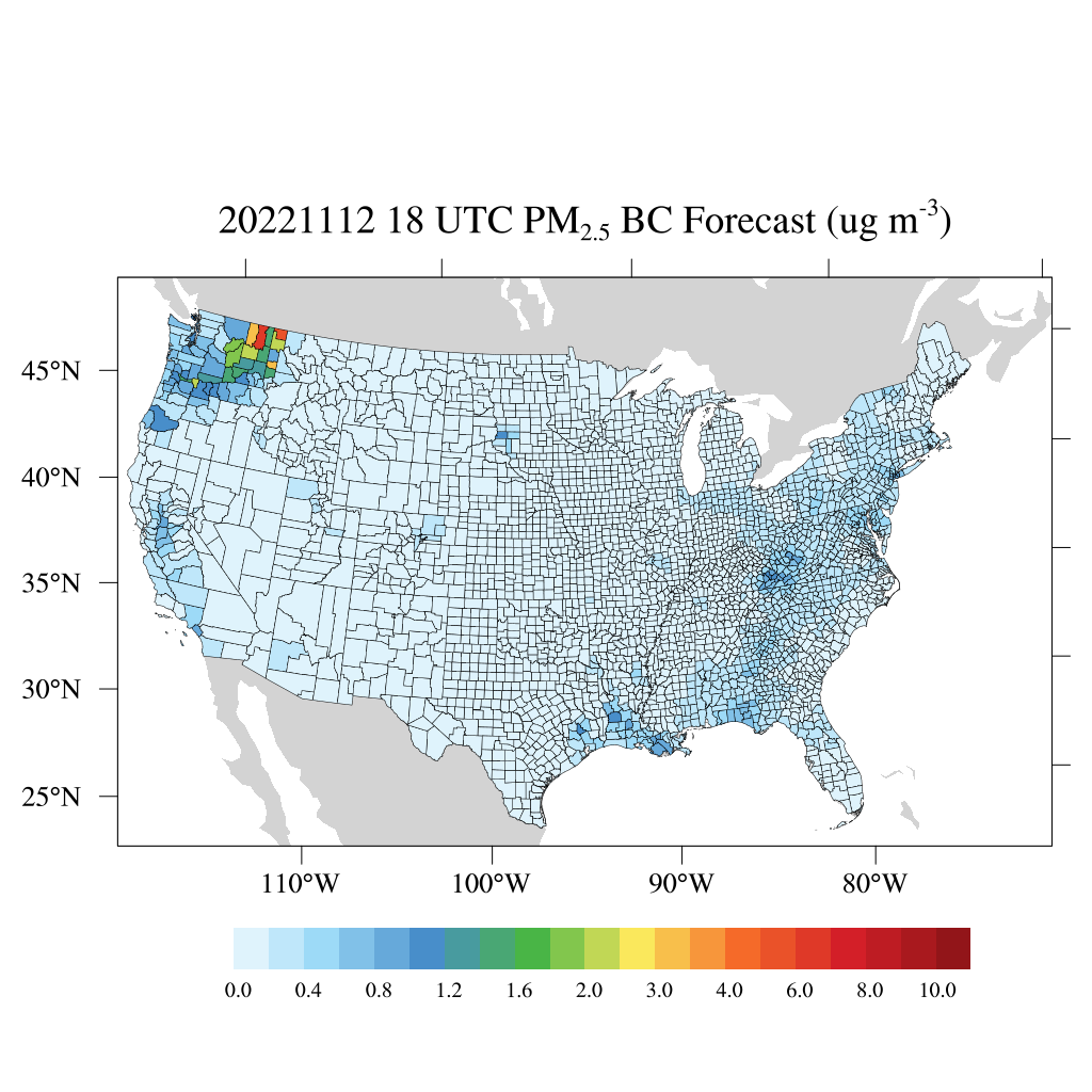
Federal
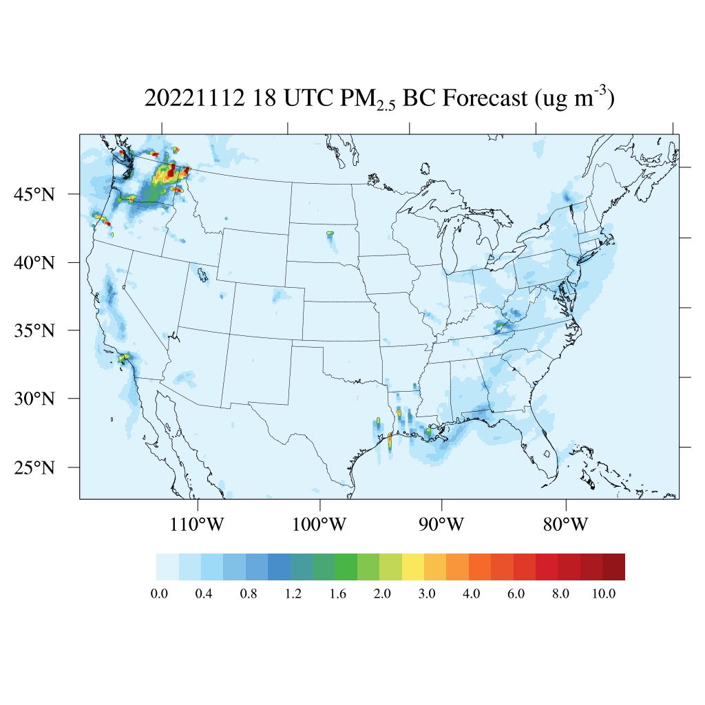
HAQES 3-Hourly Ensemble mean surface PM2.5 Black Carbon concentration, North America V1 (HAQES_NA_PM25_BC) at GES DISC
National Aeronautics and Space Administration —
This product provides HAQES 3-hourly ensemble mean surface PM2.5 Black Carbon concentration over the continental United States (CONUS) and surrounding regions. The... -
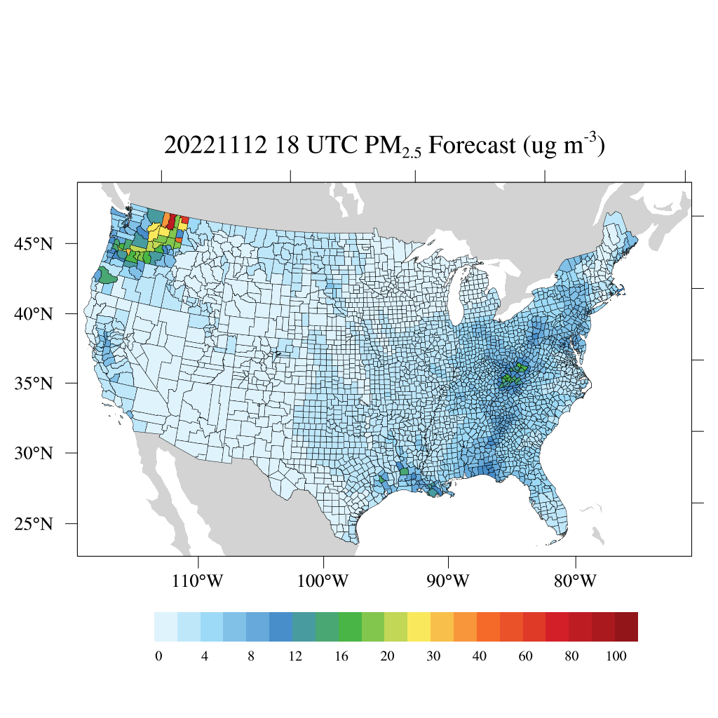
Federal
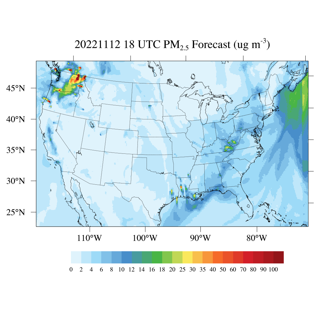
HAQES 3-Hourly Ensemble mean surface total PM2.5 concentration, North America V1 (HAQES_NA_PM25_TOT) at GES DISC
National Aeronautics and Space Administration —
This product provides HAQES 3-hourly ensemble mean surface total PM2.5 concentration over the continental United States (CONUS) and surrounding regions. The data is... -
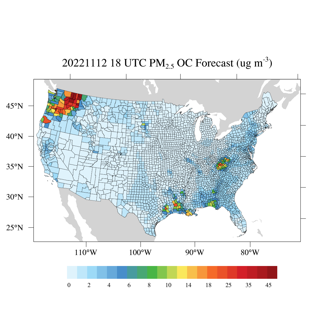
Federal
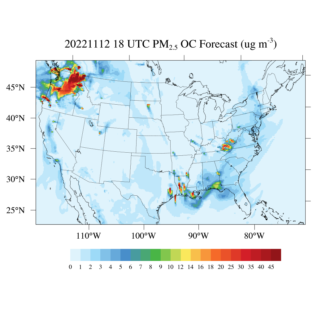
HAQES 3-Hourly Ensemble mean surface PM2.5 Organic Carbon concentration, North America V1 (HAQES_NA_PM25_OC) at GES DISC
National Aeronautics and Space Administration —
This product provides HAQES 3-hourly ensemble mean surface PM2.5 Organic Carbon concentration over the continental United States (CONUS) and surrounding regions. The... -
Federal
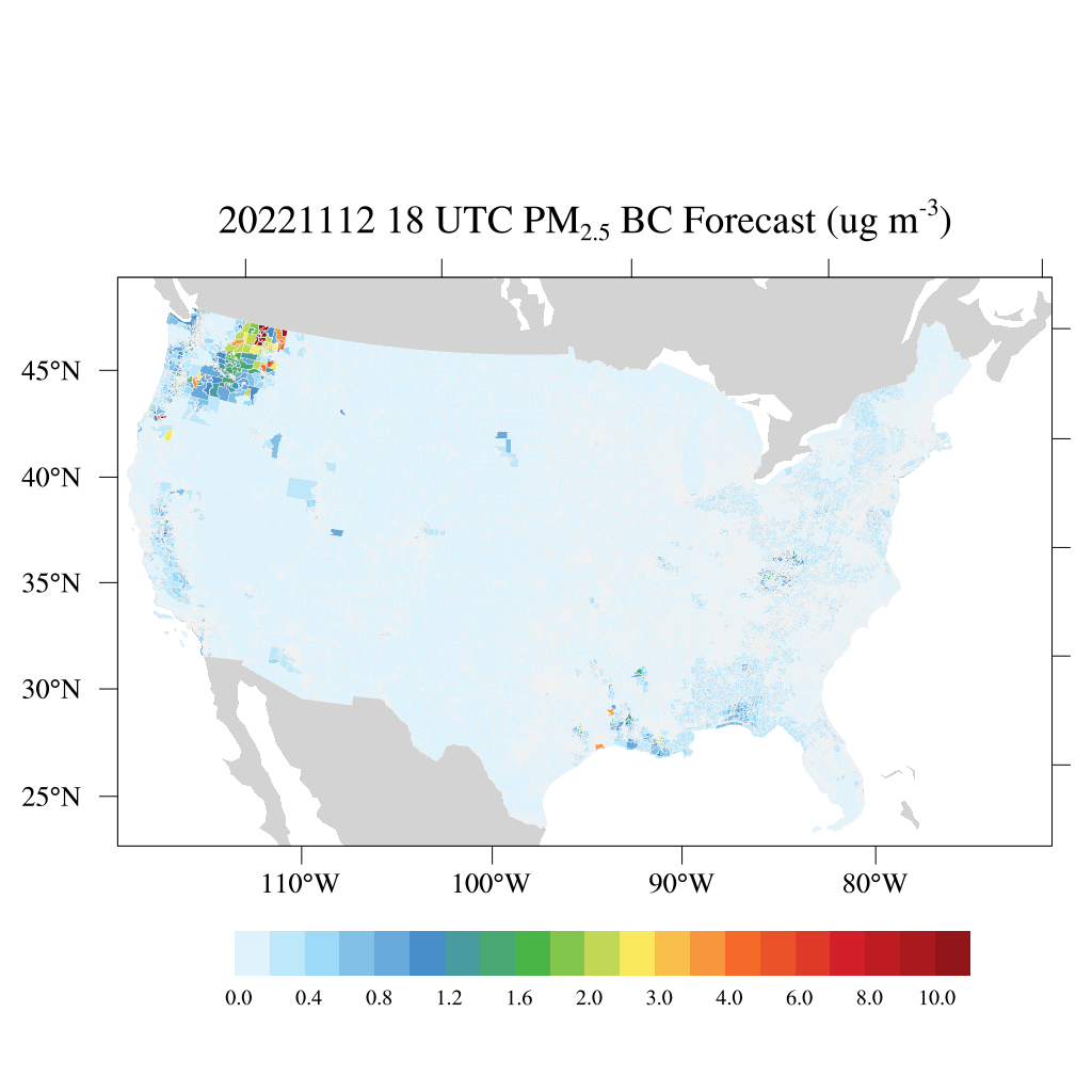
HAQES 3-Hourly Ensemble mean surface PM2.5 Black Carbon concentration at census level, North America V1 (HAQES_NA_PM25_BC_CENSUS) at GES DISC
National Aeronautics and Space Administration —
This product provides HAQES 3-hourly ensemble mean surface PM2.5 Black Carbon concentration at the census level over the continental United States (CONUS). The... -
Federal
HAQES 3-Hourly Ensemble mean surface total PM2.5 concentration at census level, North America V1 (HAQES_NA_PM25_TOT_CENSUS) at GES DISC
National Aeronautics and Space Administration —
This product provides HAQES 3-hourly ensemble mean surface total PM2.5 concentration at the census level over the continental United States (CONUS). The Hazardous Air... -
Federal
NOAA GOES-R Series Advanced Baseline Imager (ABI) Level 2 Volcanic Ash: Detection and Height (VAA)
National Oceanic and Atmospheric Administration, Department of Commerce —
The Volcanic Ash: Detection and Height product contains two images with pixel values identifying volcanic ash cloud height and volcanic ash mass loading. The ash... -
Federal
HAQES 3-Hourly Ensemble mean surface total PM2.5 concentration at county level, North America V1 (HAQES_NA_PM25_TOT_COUNTY) at GES DISC
National Aeronautics and Space Administration —
This product provides HAQES 3-hourly ensemble mean surface total PM2.5 concentration at the county level over the continental United States (CONUS). The Hazardous Air... -
Federal
HAQES 3-Hourly Ensemble mean surface PM2.5 Black Carbon concentration at county level, North America V1 (HAQES_NA_PM25_BC_COUNTY) at GES DISC
National Aeronautics and Space Administration —
This product provides HAQES 3-hourly ensemble mean surface PM2.5 Black Carbon concentration at the county level over the continental United States (CONUS). The... -
Federal
VIRGAS WB-57 Aircraft In-Situ Trace Gas Data
National Aeronautics and Space Administration —
VIRGAS_TraceGas_AircraftInSitu_Data are the in-situ trace gas data collected during the Volcano-plume Investigation Readiness and Gas-phase and Aerosol Sulfur... -
Federal
HAQES 3-Hourly Ensemble mean surface PM2.5 Organic Carbon concentration at county level, North America V1 (HAQES_NA_PM25_OC_COUNTY) at GES DISC
National Aeronautics and Space Administration —
This product provides HAQES 3-hourly ensemble mean surface PM2.5 Organic Carbon concentration at the county level over the continental United States (CONUS). The... -
Federal
Aleutian Islands Coastal Resources Inventory and Environmental Sensitivity Maps: VOLCANOS (Volcano Points)
National Oceanic and Atmospheric Administration, Department of Commerce —
This data set contains point locations of active volcanoes as compiled by Motyka et al., 1993. Eighty-nine volcanoes with eruptive phases in the Quaternary are mapped... -
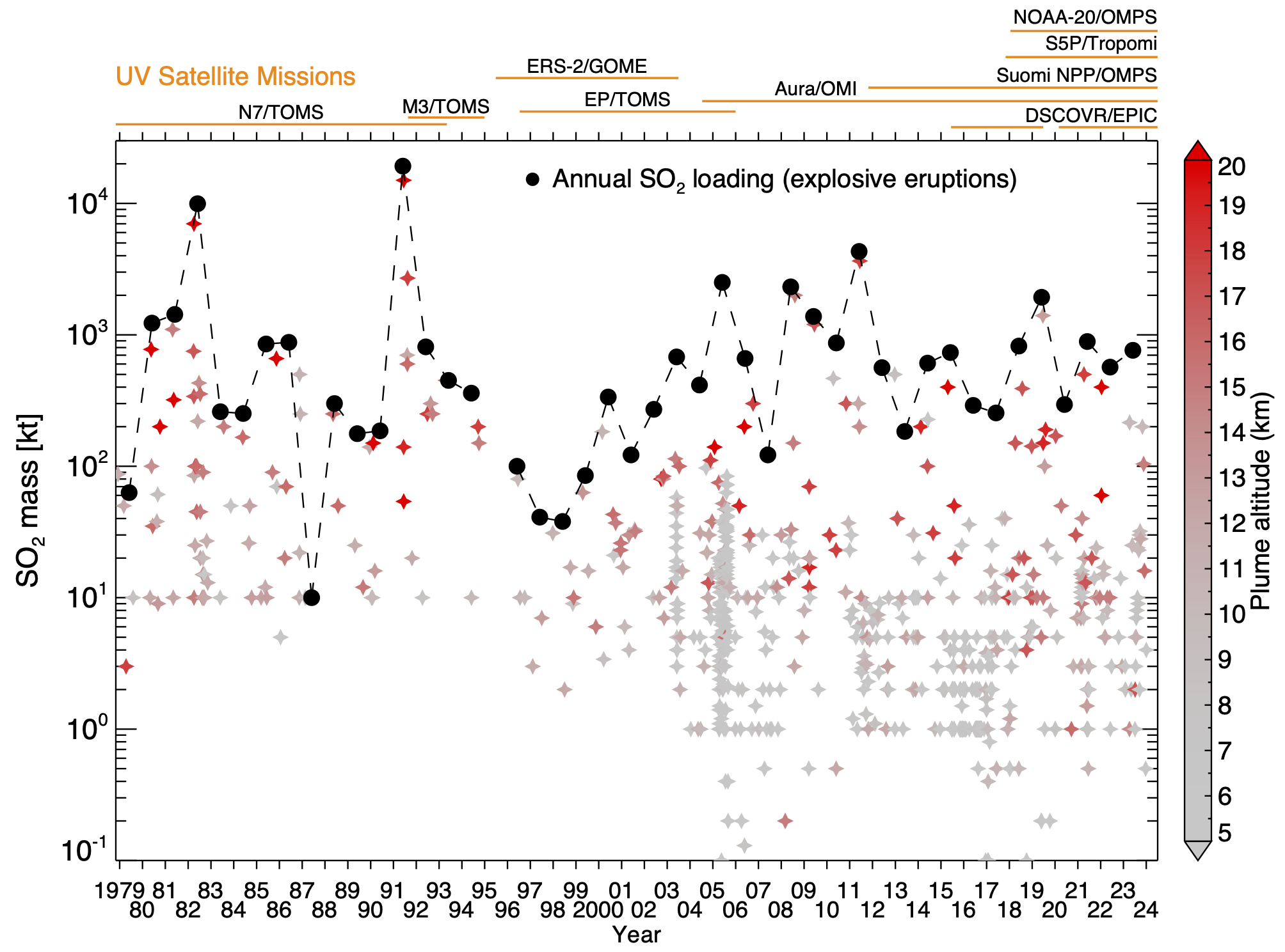
Federal
Multi-Satellite Air Quality Sulfur Dioxide (SO2) Database Long-Term L4 Global V2 (MSAQSO2L4) at GES DISC
National Aeronautics and Space Administration —
These data are a part of Multi-Decadal Sulfur Dioxide (SO2) Climatology from Satellite Instruments (MEaSUREs-12-0022 project). Version 2 of the global catalogue of... -
Federal
OMI/Aura Level 2 Sulphur Dioxide (SO2) Trace Gas Column Data 1-Orbit Subset and Collocated Swath along CloudSat V003 (OMSO2_CPR) at GES DISC
National Aeronautics and Space Administration —
This is a CloudSat-collocated subset of the original product OMSO2, for the purposes of the A-Train mission. The goal of the subset is to select and return OMI data... -
Federal
TOMS/N7 MS SO2 Vertical Column 1-Orbit L2 Swath 50x50 km V3 (TOMSN7SO2) at GES DISC
National Aeronautics and Space Administration —
Version 3 is the current version of the data set. Older versions will no longer be available and have been superseded by Version 3.The goal of this data set is to... -
Federal
VIRGAS WB-57 Aircraft In-Situ Meteorology and Navigation Data
National Aeronautics and Space Administration —
VIRGAS_MetNav_AircraftInSitu_Data are the meteorology and navigational data collected during the Volcano-plume Investigation Readiness and Gas-phase and Aerosol... -
Federal
Multi-Satellite Volcanic Sulfur Dioxide L4 Long-Term Global Database V4 (MSVOLSO2L4) at GES DISC
National Aeronautics and Space Administration —
Version 4 is the current version of the data set. Older versions are no longer available and have been superseded by Version 4.These data are a part of MEaSUREs 2012... -
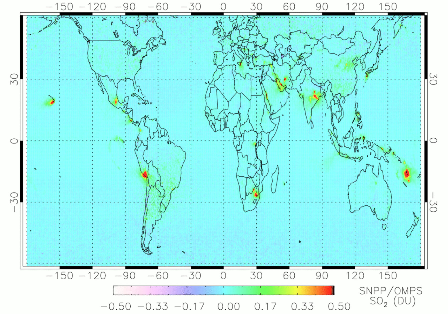
Federal
OMPS/NPP PCA SO2 Total Column 1-Orbit L2 Swath 50x50km V2 (OMPS_NPP_NMSO2_PCA_L2) at GES DISC
National Aeronautics and Space Administration —
The OMPS_NPP_NMSO2_PCA_L2 product is part of the MEaSUREs (Making Earth Science Data Records for Use in Research Environments) suite of products.It is retrieved from...

Official websites use .gov
A
.gov website belongs to an official government
organization in the United States.
Secure .gov websites use HTTPS
A
lock (
) or https:// means you’ve safely connected to
the .gov website. Share sensitive information only on official,
secure websites.