
-
Federal
Thermal Springs List for the United States (NCEI Geothermal Database)
National Oceanic and Atmospheric Administration, Department of Commerce —
The NOAA National Centers for Environmental Information ceased providing support for this product on May 05, 2025. Note this metadata record is accompanied by another... -
Federal
F00072: NOS Hydrographic Survey , 1948-09-27
National Oceanic and Atmospheric Administration, Department of Commerce —
The National Oceanic and Atmospheric Administration (NOAA) has the statutory mandate to collect hydrographic data in support of nautical chart compilation for safe... -
Federal
H12523: NOS Hydrographic Survey , 2013-08-22
National Oceanic and Atmospheric Administration, Department of Commerce —
The National Oceanic and Atmospheric Administration (NOAA) has the statutory mandate to collect hydrographic data in support of nautical chart compilation for safe... -
Federal
DEEPEN: Final 3D PFA Favorability Models and 2D Favorability Maps at Newberry Volcano
Department of Energy —
Part of the DEEPEN (DE-risking Exploration of geothermal Plays in magmatic ENvironments) project involved developing and testing a methodology for a 3D play fairway... -
Federal
AISRP Presentations
National Aeronautics and Space Administration —
AISRP Presentations from CIDU/AISRP 2009. -
Federal
H02821A: NOS Hydrographic Survey
National Oceanic and Atmospheric Administration, Department of Commerce —
The National Oceanic and Atmospheric Administration (NOAA) has the statutory mandate to collect hydrographic data in support of nautical chart compilation for safe... -
Federal
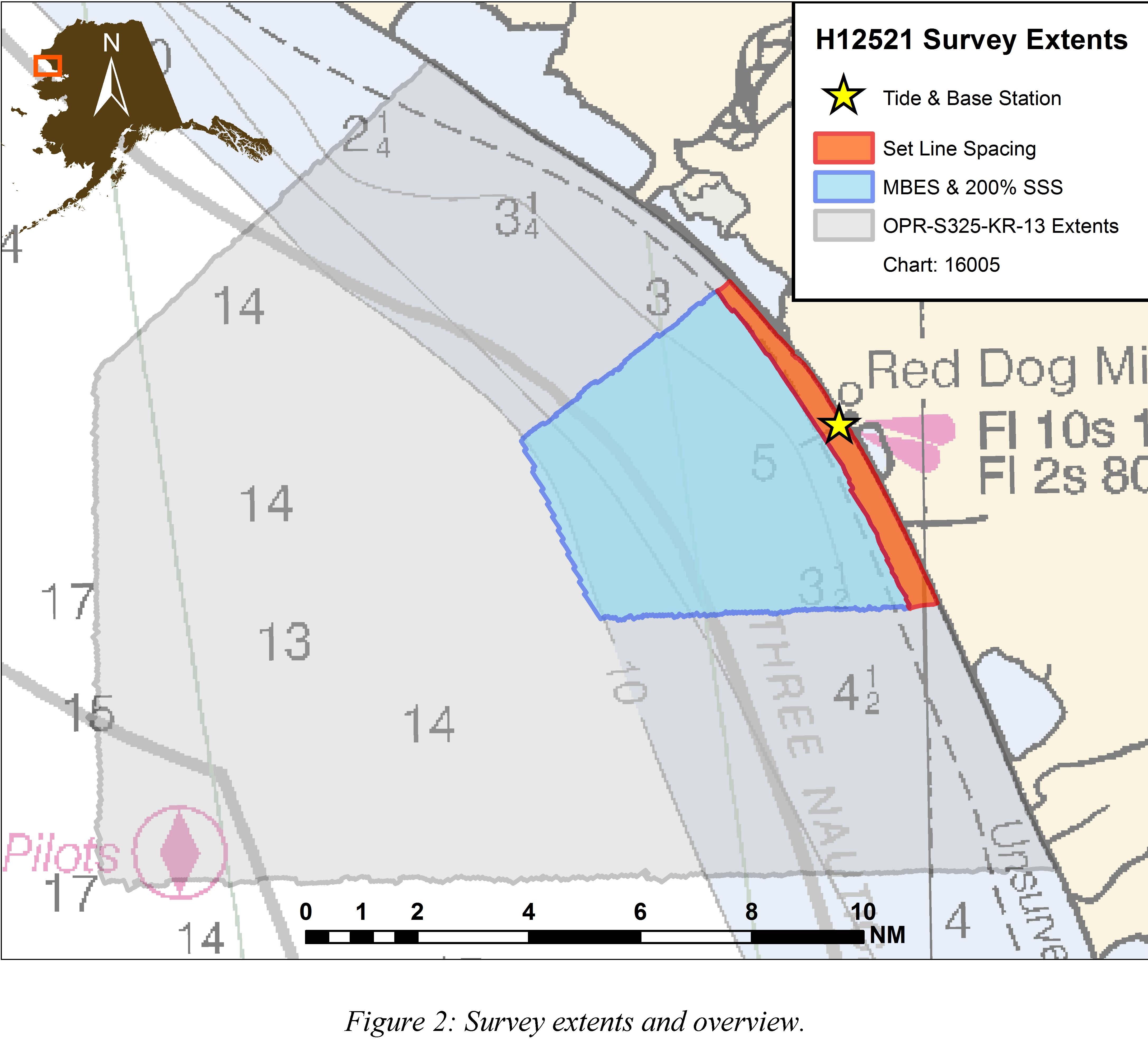
H12521: NOS Hydrographic Survey , 2013-08-22
National Oceanic and Atmospheric Administration, Department of Commerce —
The National Oceanic and Atmospheric Administration (NOAA) has the statutory mandate to collect hydrographic data in support of nautical chart compilation for safe... -
Federal
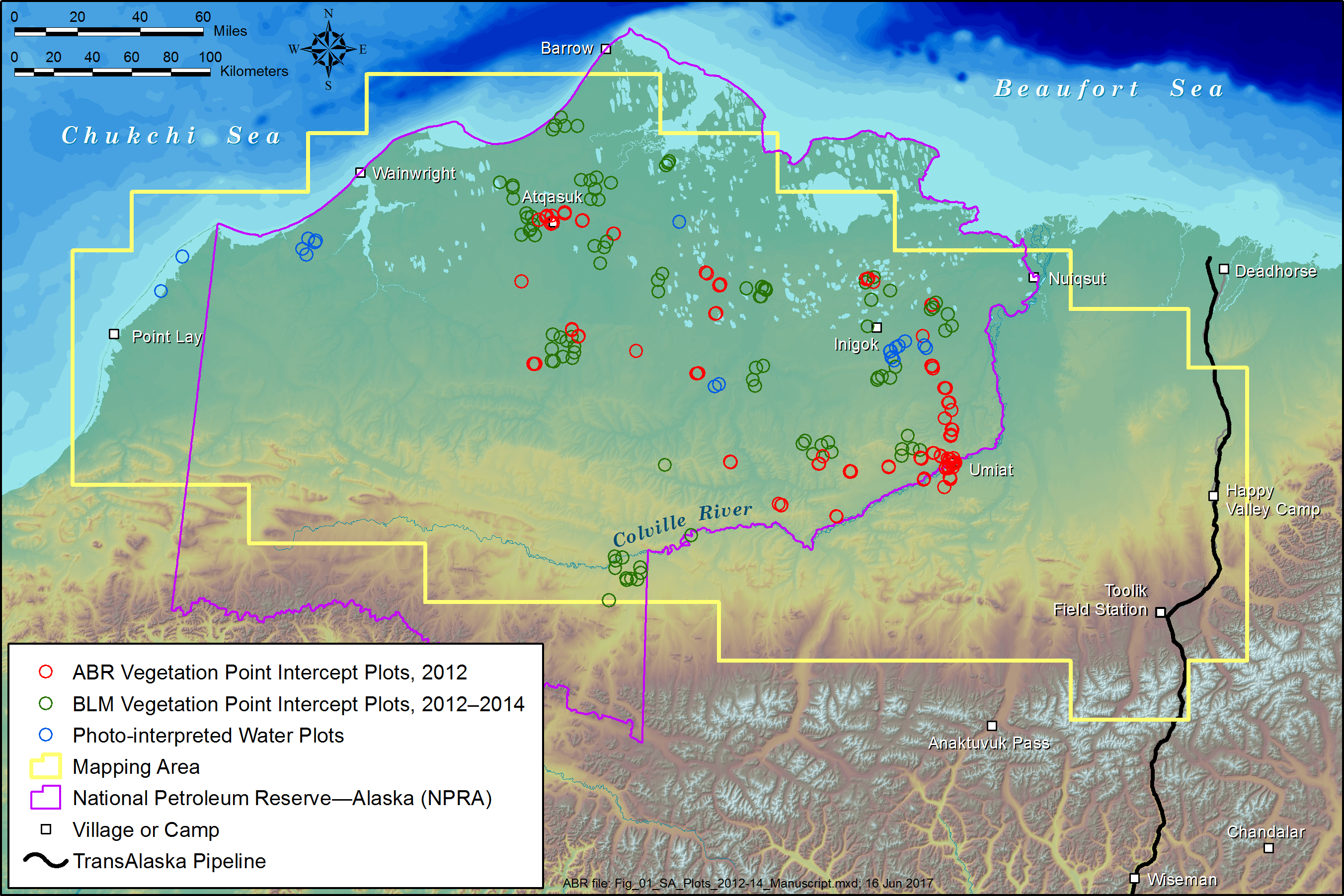
ABoVE: Tundra Plant Functional Type Continuous-Cover, North Slope, Alaska, 2010-2015
National Aeronautics and Space Administration —
This dataset provides predicted continuous-field cover for tundra plant functional types (PFTs), across ~125,000 km2 of Alaska's North Slope at 30-m resolution. The... -
Federal
A KNOWLEDGE DISCOVERY STRATEGY FOR RELATING SEA SURFACE TEMPERATURES TO FREQUENCIES OF TROPICAL STORMS AND GENERATING PREDICTIONS OF HURRICANES UNDER 21ST-CENTURY GLOBAL WARMING SCENARIOS
National Aeronautics and Space Administration —
A KNOWLEDGE DISCOVERY STRATEGY FOR RELATING SEA SURFACE TEMPERATURES TO FREQUENCIES OF TROPICAL STORMS AND GENERATING PREDICTIONS OF HURRICANES UNDER 21ST-CENTURY... -
Federal
Thermal Springs List for the United States (NCEI Accession 0303600)
National Oceanic and Atmospheric Administration, Department of Commerce —
Geothermics is the study of heat generated in Earth's interior and its manifestation at the surface. The NOAA National Centers for Environmental Information has a... -
Federal
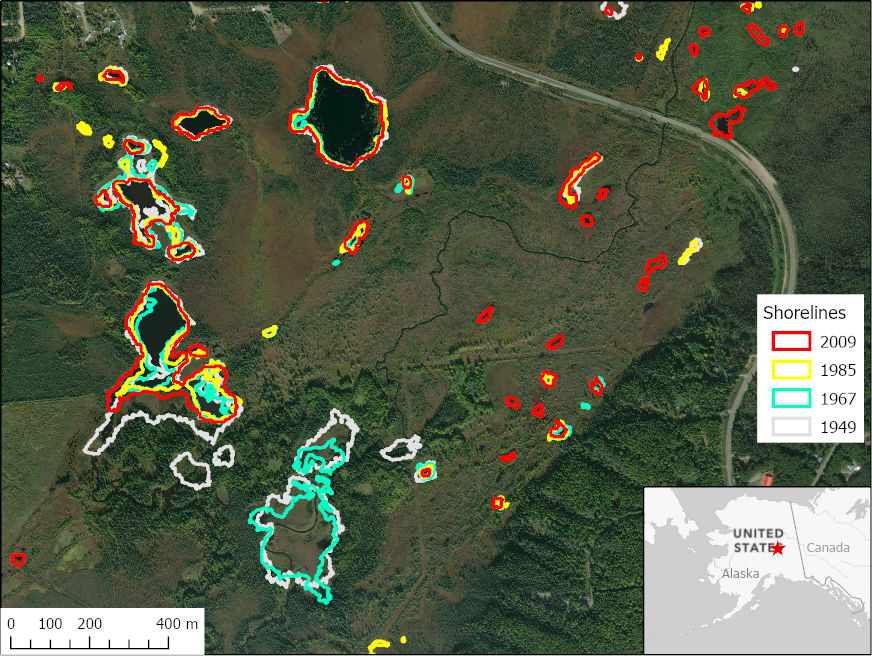
ABoVE: Historical Lake Shorelines and Areas near Fairbanks, Alaska from 1949-2009
National Aeronautics and Space Administration —
This dataset includes maps of historical lake shorelines with derived lake areas in the southern portion of the Goldstream Valley and the surrounding landscape north... -
Federal
H08352: NOS Hydrographic Survey , Ashley River, South Carolina, 1953-04-28
National Oceanic and Atmospheric Administration, Department of Commerce —
The National Oceanic and Atmospheric Administration (NOAA) has the statutory mandate to collect hydrographic data in support of nautical chart compilation for safe... -
Federal
H02770A: NOS Hydrographic Survey
National Oceanic and Atmospheric Administration, Department of Commerce —
The National Oceanic and Atmospheric Administration (NOAA) has the statutory mandate to collect hydrographic data in support of nautical chart compilation for safe... -
Federal
Nevada Great Basin Play Fairway Analysis - Reports & Appendices
Department of Energy —
This project focused on defining geothermal play fairways and development of a detailed geothermal potential map of a large transect across the Great Basin region... -
Federal
Unpublished Digital Surficial Geologic-GIS Map of the Sandy Hook and Longbranch Quadrangles and Vicinity, New Jersey (NPS, GRD, GRI, GATE, SHSF digital map) adapted from a New Jersey Geological Survey Open-file Maps by Stanford, S.D. (1995, 1999, 2000, 2002)
Department of the Interior —
The Unpublished Digital Surficial Geologic-GIS Map of the Sandy Hook and Longbranch Quadrangles and Vicinity, New Jersey is composed of GIS data layers and GIS tables... -
Federal
H12522: NOS Hydrographic Survey , 2013-08-21
National Oceanic and Atmospheric Administration, Department of Commerce —
The National Oceanic and Atmospheric Administration (NOAA) has the statutory mandate to collect hydrographic data in support of nautical chart compilation for safe... -
Federal
H02770: NOS Hydrographic Survey
National Oceanic and Atmospheric Administration, Department of Commerce —
The National Oceanic and Atmospheric Administration (NOAA) has the statutory mandate to collect hydrographic data in support of nautical chart compilation for safe...

Official websites use .gov
A
.gov website belongs to an official government
organization in the United States.
Secure .gov websites use HTTPS
A
lock (
) or https:// means you’ve safely connected to
the .gov website. Share sensitive information only on official,
secure websites.