

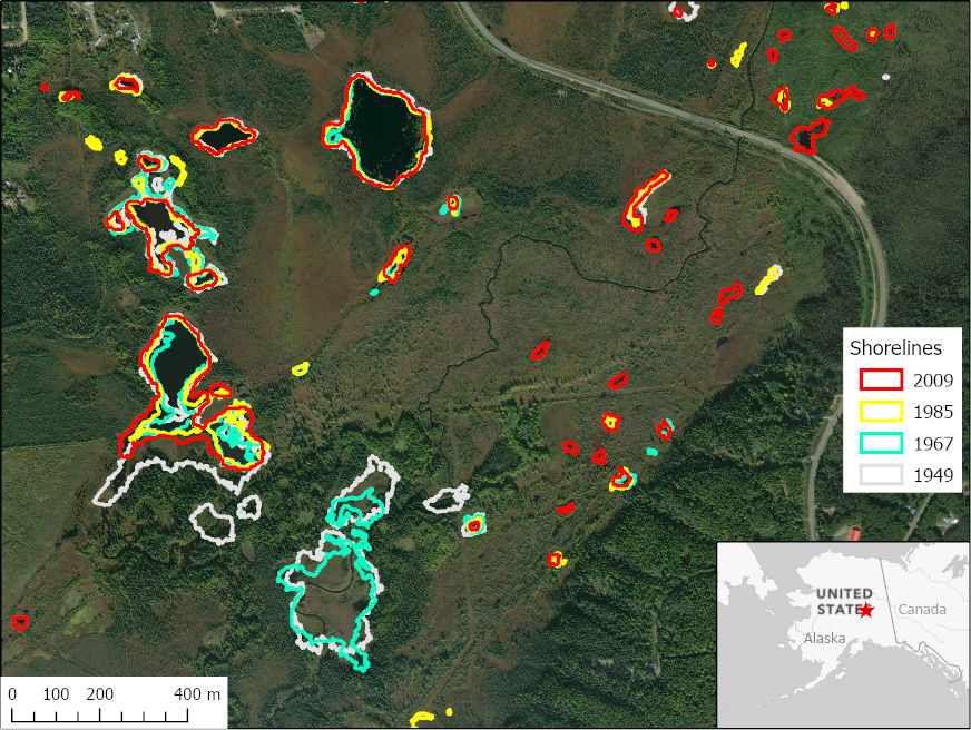
ABoVE: Historical Lake Shorelines and Areas near Fairbanks, Alaska from 1949-2009
Access & Use Information
Public: This dataset is intended for public access and use.
License: No license information was provided. If this work was prepared by an officer or employee of the United States government as part of that person's official duties it is considered a U.S. Government Work.
Downloads & Resources
-
Data Information (Unknown Format)BIN
-
Data Information (HTML)HTML
-
Data Information (ZIP)ZIP
Historical_Lake_Shorelines_AK_1859.zip
-
Data Information (JPEG)JPEG
Historical_Lake_Shorelines_AK_Fig1.jpg
-
Data Information (Unknown Format)BIN
-
Data Information (PDF)PDF
Historical_Lake_Shorelines_AK.pdf
-
Landing PageLanding Page
Dates
| Metadata Created Date | April 11, 2025 |
|---|---|
| Metadata Updated Date | October 23, 2025 |
Metadata Source
- Data.json Data.json Metadata
Harvested from NASA Data.json
Additional Metadata
| Resource Type | Dataset |
|---|---|
| Metadata Created Date | April 11, 2025 |
| Metadata Updated Date | October 23, 2025 |
| Publisher | ORNL_DAAC |
| Maintainer | |
| Identifier | 10.3334/ORNLDAAC/1859 |
| Data Last Modified | 2025-09-10 |
| Category | Earth Science |
| Public Access Level | public |
| Bureau Code | 026:00 |
| Metadata Context | https://project-open-data.cio.gov/v1.1/schema/catalog.jsonld |
| Schema Version | https://project-open-data.cio.gov/v1.1/schema |
| Catalog Describedby | https://project-open-data.cio.gov/v1.1/schema/catalog.json |
| Harvest Object Id | 5ec80112-b253-4c50-a3f4-975f8bedaad0 |
| Harvest Source Id | 58f92550-7a01-4f00-b1b2-8dc953bd598f |
| Harvest Source Title | NASA Data.json |
| Homepage URL | https://search.earthdata.nasa.gov/search?q=Historical_Lake_Shorelines_AK_1859&ac=true |
| Old Spatial | {"WestBoundingCoordinate":-147.98,"NorthBoundingCoordinate":64.96,"EastBoundingCoordinate":-147.66,"SouthBoundingCoordinate":64.8282},"CARTESIAN" |
| Program Code | 026:000 |
| Source Datajson Identifier | True |
| Source Hash | 80cebe2787a8c6ee6b44e0dd676d587fdc246dc96865f40fbadff42b02c7eaea |
| Source Schema Version | 1.1 |
| Spatial | |
| Temporal | 1949-01-01/1949-01-01 |
Didn't find what you're looking for? Suggest a dataset here.