
-
Federal
2024 County-Level Hourly Renewable Capacity Factor Dataset for the ReEDS Model
Department of Energy —
This dataset contains hourly capacity factors for each renewable resource class and region (in this case, county). Technologies like large-scale utility PV (UPV),... -
Federal
NUOnet (Nutrient Use and Outcome Network) database
Department of Agriculture —
NUOnet Vision: Efficient use of nutrients to optimize production and product quality of food for animals and humans, fuel and fiber in a sustainable manner that... -
Federal
F00595: NOS Hydrographic Survey , NW Approach to Key West, Florida, 2010-08-23
National Oceanic and Atmospheric Administration, Department of Commerce —
The National Oceanic and Atmospheric Administration (NOAA) has the statutory mandate to collect hydrographic data in support of nautical chart compilation for safe... -
Federal
CMAQv5.5 CRACMM2 Predictions for Select Locations during 2023 in the U.S.: Northeast U.S. (v2.0)
U.S. Environmental Protection Agency —
2023 CMAQ Simulation output for select sites in the Northeast US - CMAQ simulations performed by Havala Pye ORD/CEMM/AESMD - simulation labels: cmaq55plus (base) and... -
Federal
EnviroAtlas - Water Balance and Surficial Groundwater by 12-digit HUC for the Conterminous United States
U.S. Environmental Protection Agency —
This EnviroAtlas dataset summarizes several U.S. Geological Survey (USGS) water budget and surficial groundwater datasets by 12-digit HUC. It includes average rates... -
Federal
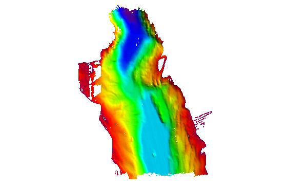
H12110: NOS Hydrographic Survey , San Fransisco Bay, California, 2009-08-03
National Oceanic and Atmospheric Administration, Department of Commerce —
The National Oceanic and Atmospheric Administration (NOAA) has the statutory mandate to collect hydrographic data in support of nautical chart compilation for safe... -
Federal
NLCD 2016 Land Cover Reference Data, Conterminous United States NGDA
U.S. Environmental Protection Agency —
The U.S. Geological Survey (USGS), in partnership with several federal agencies, has developed and released five National Land Cover Database (NLCD) products over the... -
State
DWR Airborne Electromagnetic (AEM) Surveys Data
State of California —
Statewide AEM Surveys Project Overview The Department of Water Resources’ (DWR’s) Statewide Airborne Electromagnetic (AEM) Surveys Project is funded through... -
City
Land Cover Raster Data (2017) – 6in Resolution
City of New York —
A 6-in resolution 8-class land cover dataset derived from the 2017 Light Detection and Ranging (LiDAR) data capture. This dataset was developed as part of an updated... -
Federal
H11517: NOS Hydrographic Survey , Southwestern Alaskan Peninsula, Alaska, 2006-06-15
National Oceanic and Atmospheric Administration, Department of Commerce —
The National Oceanic and Atmospheric Administration (NOAA) has the statutory mandate to collect hydrographic data in support of nautical chart compilation for safe... -
Federal
H11697: NOS Hydrographic Survey , Chatham Strait, Alaska, 2007-09-04
National Oceanic and Atmospheric Administration, Department of Commerce —
The National Oceanic and Atmospheric Administration (NOAA) has the statutory mandate to collect hydrographic data in support of nautical chart compilation for safe... -
Federal
Buildings Sector Scenarios (BSS)
Department of Energy —
The Buildings Sector Scenarios (BSS) dataset establishes and simulates a plausible range of scenarios for U.S. buildings sector development between now and 2050 with... -
Federal
Utility-Scale Solar, 2023 Edition: Analysis of Empirical Plant-level Data from U.S. Ground-mounted PV, PV+battery, and CSP Plants (exceeding 5 MWAC)
Department of Energy —
Berkeley Labs "Utility-Scale Solar", 2023 Edition presents analysis of empirical plant-level data from the U.S. fleet of ground-mounted photovoltaic (PV), PV+battery,... -
Federal
H11873: NOS Hydrographic Survey , Mid-Atlantic Corridor, Maryland, 2008-12-18
National Oceanic and Atmospheric Administration, Department of Commerce —
The National Oceanic and Atmospheric Administration (NOAA) has the statutory mandate to collect hydrographic data in support of nautical chart compilation for safe... -
Federal
Data describing reactive organic carbon and its potential health risk in wildfire smoke v1.0
U.S. Environmental Protection Agency —
This data archive supports the publication by Pye et al. 2024 applying the CMAQ model to FIREX-AQ field campaign. Links are provided for the standard CMAQ model,... -
Federal
ARPA-E Grid Optimization (GO) Competition Challenge 3
Department of Energy —
Synthetic Input Data and Team Results for the GO Competition Challenge 3 for Events 1 - 4 and the Sandbox, along with problem and format descriptions and code to... -
Federal
Enhancing and Optimization of MADWEC Performance Through Numerical Simulations
Department of Energy —
This set of data was the result of the TEAMER project led by Adam Keester (Sandia) and Dr. Mohamed Shabara (NREL) on 'enhancing and optimization of maximal asymmetric... -
Federal
H11494: NOS Hydrographic Survey , Prince William Sound, Alaska, 2005-09-22
National Oceanic and Atmospheric Administration, Department of Commerce —
The National Oceanic and Atmospheric Administration (NOAA) has the statutory mandate to collect hydrographic data in support of nautical chart compilation for safe... -
Federal
In situ thermography of the metal bridge structures fabricated for the 2018 Additive Manufacturing Benchmark Test Series (AM-Bench 2018)
National Institute of Standards and Technology —
These measurements were performed as part of the 2018 Additive Manufacturing Benchmark Test Series (AM-Bench). This dataset and the associated experiments are part of...

Official websites use .gov
A
.gov website belongs to an official government
organization in the United States.
Secure .gov websites use HTTPS
A
lock (
) or https:// means you’ve safely connected to
the .gov website. Share sensitive information only on official,
secure websites.