
-
Federal
U.S. Billion-dollar Weather and Climate Disasters, 1980 - present (NCEI Accession 0209268)
National Oceanic and Atmospheric Administration, Department of Commerce —
The NOAA National Centers for Environmental Information ceased providing support for this product in May 2025 in response to an initiative to implement reductions... -
County
Allegheny County 911 Dispatches - EMS and Fire
Allegheny County / City of Pittsburgh / Western PA Regional Data Center —
The Allegheny County 911 center answers and dispatches 911 calls for 111 out of 130 municipalities in Allegheny County. Agencies are dispatched via a computer aided... -
Federal
GEOS-Carb CASA-GFED Daily Fire and Fuel Emissions 0.5 degree x 0.5 degree V3 (GEOS_CASAGFED_D_FIRE) at GES DISC
National Aeronautics and Space Administration —
This product provides Daily average wildfire emissions (FIRE) andfuel wood burning emissions (FUEL) derived from the Carnegie-Ames-Stanford-Approach – Global Fire... -
Federal
Critical Facilities for Coastal Geographies
National Oceanic and Atmospheric Administration, Department of Commerce —
The critical facilities data are derived from the USGS Structures Inventory Database (June, 2016). The structures in the derived dataset displays aggregated totals of... -
Federal
Land Use and Cover Maps from Landsat, Mawas, Central Kalimantan, Indonesia, 1994-2019
National Aeronautics and Space Administration —
This dataset contains annual land use/cover (LUC) maps at 30 m resolution across Mawas, Central Kalimantan, Indonesia. There are six files, each representing a five-... -
Federal
Military Special Use Airspace
National Oceanic and Atmospheric Administration, Department of Commerce —
Military Special Use Airspace is airspace of defined dimensions identified by an area on the surface of the earth wherein activities must be confined because of their... -
Federal
Automation of Field Operations and Services (AFOS) National Weather Service (NWS) Service Records and Retention System (SRRS) Data
National Oceanic and Atmospheric Administration, Department of Commerce —
Service Records and Retention System (SRRS) is historical digital data set DSI-9949, a collection of products created by the U.S. National Weather Service (NWS) and... -
Federal
Vegetation data from Valles Caldera National Preserve's Cerro Seco Unit 5 forest restoration project, 2016-2022
Department of the Interior —
Vegetation data files from the Cerro Seco Unit 5 forest restoration project (thinning, prescribed slash burning) during 2016-2022. -
Federal
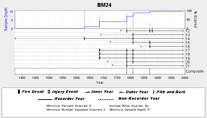
NOAA/WDS Paleoclimatology - Veblen fire data from BM24 - IMPD USBM-024
National Oceanic and Atmospheric Administration, Department of Commerce —
This archived Paleoclimatology Study is available from the NOAA National Centers for Environmental Information (NCEI), under the World Data Service (WDS) for... -
Federal
NCCOS Assessment: Prescribed Fire in Coastal Alabama and Mississippi, 1992-01-01 to 2022-12-31
National Oceanic and Atmospheric Administration, Department of Commerce —
This dataset includes smoke and prescribed fire density from the National Centers for Coastal Ocean Science (NCCOS) Social Science team's Prescribed Fire project in... -
Federal
H05104: NOS Hydrographic Survey , 1930-12-31
National Oceanic and Atmospheric Administration, Department of Commerce —
The National Oceanic and Atmospheric Administration (NOAA) has the statutory mandate to collect hydrographic data in support of nautical chart compilation for safe... -
Federal
First ISCCP Regional Experiment (FIRE) Atlantic Stratocumulus Transition Experiment (ASTEX) Meteosat Satellite Data
National Aeronautics and Space Administration —
The First ISCCP Regional Experiments (FIRE) have been designed to improve data products and cloud/radiation parameterizations used in general circulation models... -
Federal
ABoVE: Thaw Depth at Selected Unburned and Burned Sites Across Alaska
National Aeronautics and Space Administration —
This dataset provides thaw depth measurements made at seven locations across Alaska, during August 2016, June and September 2017, and July-August 2018. Three of the... -
Federal
Imagery data for the Vegetation Mapping Inventory Project of Minidoka National Historic Site
Department of the Interior —
This reference contains the imagery data used in the completion of the baseline vegetation inventory project for the NPS park unit. Orthophotos, raw imagery, and... -
Federal
Experimental Measurements for Pyrolysis Model Validation - Anaerobic Gasification of PMMA Under External Thermal Radiation
Department of Commerce —
A set of 10 anaerobic gasification experiments was conducted on the poly(methyl methacrylate), PMMA, made available to participants in the MaCFP-2 Workshop. In each... -
Federal
Aviation Safety Reporting System: Cabin Smoke, Fire, Fumes, or Odor Incidents
National Aeronautics and Space Administration —
A sampling of air carrier reports concerning cabin smoke, fire, fumes or odor related events. -
Federal
First ISCCP Regional Experiment (FIRE) Cirrus 2 Volume Imaging Lidar (VIL) Altitude vs. Time (RTI) Data
National Aeronautics and Space Administration —
The First ISCCP Regional Experiments have been designed to improve data products and cloud/radiation parameterizations used in general circulation models (GCMs).... -
Federal
CAR SCAR-B Smoke, Clouds, and Radiation-Brazil L1 V1 (CAR_SCARB_L1C) at GES DISC
National Aeronautics and Space Administration —
The objectives for the SCAR mission are to advance our knowledge of how the physical, chemical and radiative processes in our atmosphere are affected by sulfate... -
Federal
FIREX-AQ Analysis and Supplementary Data
National Aeronautics and Space Administration —
FIREXAQ_Analysis_Data are supplementary analysis and ancillary data collected during FIREX-AQ. This product includes plume ratios, and supplementary datasets...

Official websites use .gov
A
.gov website belongs to an official government
organization in the United States.
Secure .gov websites use HTTPS
A
lock (
) or https:// means you’ve safely connected to
the .gov website. Share sensitive information only on official,
secure websites.