
-
Federal
USDA Nutrient Data Set for Retail Meat Cuts: Beef, Lamb, Pork and Veal
Department of Agriculture —
The United States Department of Agriculture (USDA) Nutrient Data Laboratory (NDL), in collaboration with the National Cattlemen's Beef Association, National Pork... -
Federal
ASTER Global Digital Elevation Model V003
National Aeronautics and Space Administration —
The Terra Advanced Spaceborne Thermal Emission and Reflection Radiometer (ASTER) Global Digital Elevation Model (GDEM) Version 3 (ASTGTM) provides a global digital... -
Federal
ARPA-E Grid Optimization (GO) Competition Challenge 2
Department of Energy —
The ARPA-E Grid Optimization (GO) Competition Challenge 2, from 2020 to 2021, expanded upon the problem posed in Challenge 1 by adding adjustable transformer tap... -
Federal
ARPA-E Grid Optimization (GO) Competition Challenge 1
Department of Energy —
The ARPA-E Grid Optimization (GO) Competition Challenge 1, from 2018 to 2019, focused on the basic Security Constrained AC Optimal Power Flow problem (SCOPF) for a... -
Federal
TRACE-A In Situ DC-8 Meteorology and Navigation Data
National Aeronautics and Space Administration —
TRACE-A_MetNav_AircraftInSitu_DC8_Data is the in situ meteorology and navigation data collected onboard the DC-8 aircraft during the Transport and Atmospheric... -
Federal
CERES-MODIS-VIIRS and hourly geostationary cloud properties stratified by ISCCP cloud types for day and night.
National Aeronautics and Space Administration —
CER_CldTypHist_GEO-MODIS-VIIRS_Edition4A is the Clouds and the Earth's Radiant Energy System (CERES)- Moderate-Resolution Imaging Spectroradiometer (MODIS) and... -
Federal
MODIS/Terra Net Evapotranspiration 8-Day L4 Global 500m SIN Grid V006
National Aeronautics and Space Administration —
The MOD16A2 Version 6 data product was decommissioned on July 31, 2023. Users are encouraged to use the MOD16A2... -
Federal
Northeast Snowfall Impact Scale (NESIS)
National Oceanic and Atmospheric Administration, Department of Commerce —
While the Fujita and Saffir-Simpson Scales characterize tornadoes and hurricanes respectively, there is no widely used scale to classify snowstorms. The Northeast... -
Federal
Model and experimental validation of ocean kite dynamics and controls
Department of Energy —
This submission includes two peer-reviewed papers from researchers at North Carolina State University presenting the modeling and lab-scale experimentation of the... -
Federal
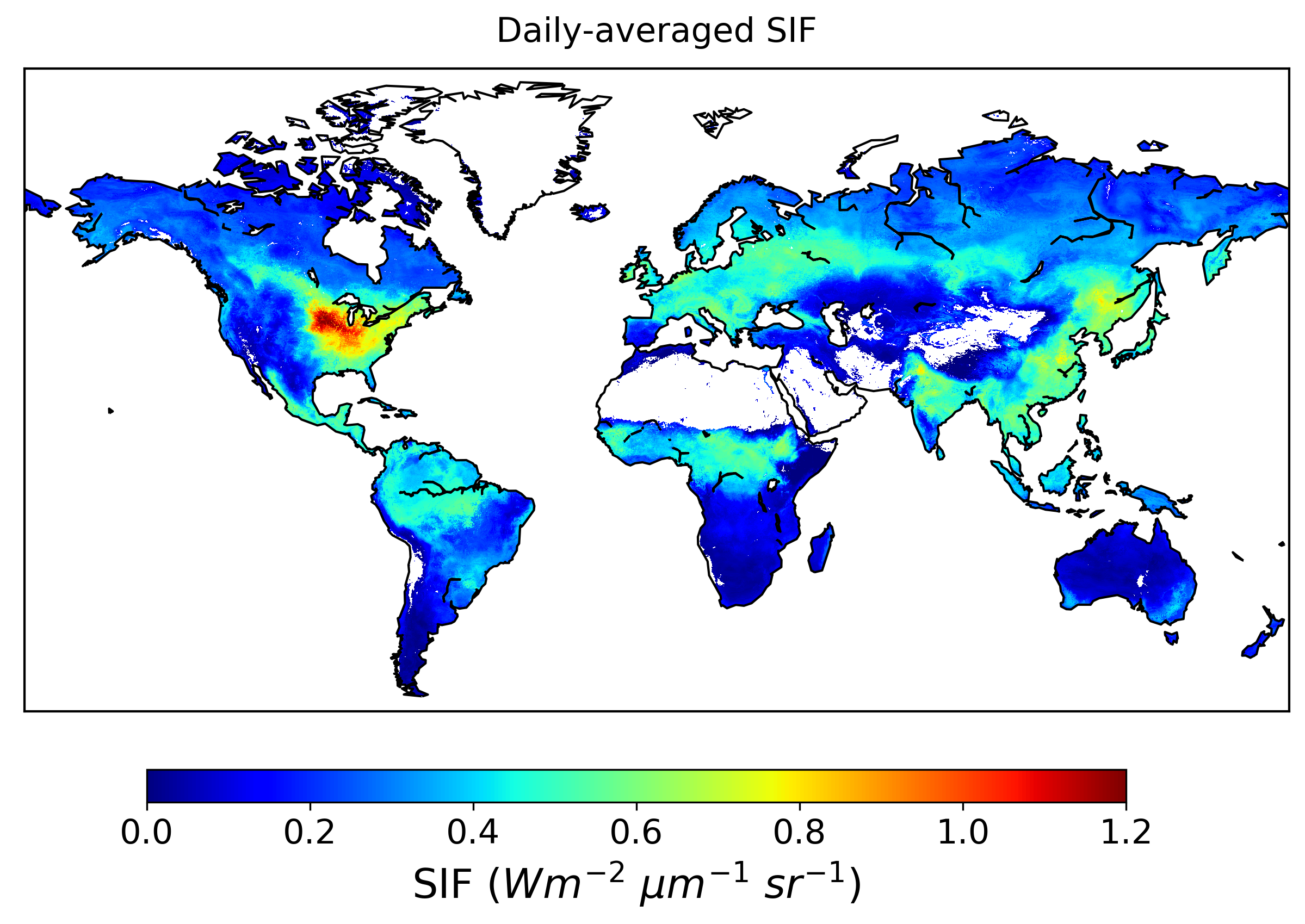
Global High-Resolution Estimates of SIF from Fused SCIAMACHY and GOME-2, V2
National Aeronautics and Space Administration —
This dataset provides global solar-induced chlorophyll fluorescence (SIF) estimates at a 0.05-degree resolution (approximately 5 km at the equator) for each month... -
Federal
AFSC/NMML/CCEP: Diet of Pacific harbor seals at Umpqua River, Oregon and Columbia River, Oregon/Washington during 1994 through 2005
National Oceanic and Atmospheric Administration, Department of Commerce —
From 1994 to 2005, The National Marine Mammal Laboratories' California Current Ecosystem Program (AFSC/NOAA) collected fecal samples at the Umpqua River, Oregon and... -
Federal
EMIT L2A Estimated Surface Reflectance and Uncertainty and Masks 60 m V001
National Aeronautics and Space Administration —
The Earth Surface Mineral Dust Source Investigation (EMIT) instrument measures surface mineralogy, targeting the Earth’s arid dust source regions. EMIT is installed... -
Federal
NOAA Geostationary Operational Environmental Satellite (GOES) I-M and N-P Series Imager Data NGDA
National Oceanic and Atmospheric Administration, Department of Commerce —
The NOAA Geostationary Operational Environmental Satellite (GOES) series provides continuous measurements of the atmosphere and surface over the Western Hemisphere.... -
Federal
R-Factor for the Conterminous United States
National Oceanic and Atmospheric Administration, Department of Commerce —
The rainfall-runoff erosivity factor (R-Factor) quantifies the effects of raindrop impacts and reflects the amount and rate of runoff associated with the rain. The... -
Federal
RANS Simulation ADM of the NREL Phase VI wind turbine modeled as MHK Turbine
Department of Energy —
Attached are the .cas and .dat files for the Reynolds Averaged Navier-Stokes (RANS) simulation of a single lab-scaled DOE RM1 turbine implemented in ANSYS FLUENT CFD-... -
Federal
Hybrid machine learning model to predict 3D in-situ permeability evolution
Department of Energy —
Enhanced geothermal systems (EGS) can provide a sustainable and renewable solution to the new energy transition. Its potential relies on the ability to create a... -
Federal
MODIS/Terra Net Evapotranspiration Gap-Filled Yearly L4 Global 500m SIN Grid V006
National Aeronautics and Space Administration —
The MOD16A3GF Version 6 data product was decommissioned on July 31, 2023. Users are encouraged to use theFederalRANS Simulation VBM of Array of Three Coaxial Lab Scaled DOE RM1 MHK Turbine with 5D Spacing
Department of Energy —
Attached are the .cas and .dat files along with the required User Defined Functions (UDFs) and look-up table of lift and drag coefficients for the Reynolds Averaged...FederalVIIRS/NPP Actual and Potential Evapotranspiration Gap-Filled 8-Day L4 Global 500m SIN Grid V002
National Aeronautics and Space Administration —
The NASA/NOAA Suomi National Polar-orbiting Partnership (Suomi NPP) Visible Infrared Imaging Radiometer Suite (VIIRS) Actual and Potential Evapotranspiration product...FederalCYGNSS Level 1 Science Data Record Version 3.2
National Aeronautics and Space Administration —
This CYGNSS Level 1 (L1) science data record dataset contains the version 3.2 geo-located Delay Doppler Maps (DDMs) calibrated into Power Received (Watts) and...339 datasets found for "Equator"

Official websites use .gov
A
.gov website belongs to an official government
organization in the United States.
Secure .gov websites use HTTPS
A
lock (
) or https:// means you’ve safely connected to
the .gov website. Share sensitive information only on official,
secure websites.