
-
Federal
Utility Outage Information
Department of Energy —
Data about power company service areas and their announcements about outages are critical for the effective coordination of resources after disasters, and also for... -
Federal
Radio Access Network Anomalous State Detection Dataset
National Institute of Standards and Technology —
This project [1] produced two types of data: Working Data and Derived Data. The Working Data includes raw measurements collected from a Radio Access Network (RAN)... -
Federal
Dataset of channels and received IEEE 802.11ay signals for sensing applications in the 60GHz band
National Institute of Standards and Technology —
The dataset can be used to develop and test algorithms for communication and sensing in the 60GHz band. The dataset consists of synthetically generated indoor mm-wave... -
Federal
Dataset for A Robust, Over-the-Air Test Bed for Radio-Frequency Fingerprinting of Cellular Devices
National Institute of Standards and Technology —
This dataset contains results represented in the work titled 'A Robust, Over-the-Air Test Bed for Radio-Frequency Fingerprinting of Cellular Devices', whose abstract... -
Federal
Deterministic Move Lists for Federal Incumbent Protection in the CBRS Band
National Institute of Standards and Technology —
The 3.5 GHz citizens broadband radio service (CBRS) band in the U.S. is a key portion of mid-band spectrum shared between commercial operators and existing federal... -
Federal
Recommended Practices for Calibrated Millimeter-Wave Modulated-Signal Measurements
National Institute of Standards and Technology —
In this paper, we have demonstrated the importance of choosing the correct reference plane for applications such as over-the-air (OTA) modulated-signal measurements... -
Federal
NOAA/WDS Paleoclimatology - Dongdao Island 1000 Year Grain Size and Stable Isotope Data
National Oceanic and Atmospheric Administration, Department of Commerce —
This archived Paleoclimatology Study is available from the NOAA National Centers for Environmental Information (NCEI), under the World Data Service (WDS) for... -
Federal
Radio Access Network Anomalous State Detection Dataset
Department of Commerce —
This project [1] produced two types of data: Working Data and Derived Data. The Working Data includes raw measurements collected from a Radio Access Network (RAN)... -
Federal
anomaly channels NGDA
Department of the Interior —
Since 1998, geoscientists at the Bureau of Ocean Energy Management (BOEM) have identified and mapped over 31,000 water bottom (seafloor) acoustic amplitude anomalies... -
Federal
NOAA/WDS Paleoclimatology - Northeast African Precipitation and Vegetation Biomarker Data over the last 4.5 million years
National Oceanic and Atmospheric Administration, Department of Commerce —
This archived Paleoclimatology Study is available from the NOAA National Centers for Environmental Information (NCEI), under the World Data Service (WDS) for... -
Federal
Rainfall simulation experiments in the Southwestern USA using the Walnut Gulch Rainfall Simulator
Department of Agriculture —
Introduction Preservation and management of semi-arid ecosystems requires understanding of the processes involved in soil erosion and their interaction with plant... -
Federal
Correlation-Matrix Approaches for Testing Wireless Devices in Reverberation Chambers
Department of Commerce —
The data correspond to the paper Practical Correlation-Matrix Approaches for Standardized Testing of Wireless Devices in Reverberation Chambers. Abstract: We extend... -
Federal
ICON - Port Everglades 2012 Meteorological Observations (NODC Accession 0117727)
National Oceanic and Atmospheric Administration, Department of Commerce —
The Atlantic Oceanographic and Meteorological Laboratory (AOML) of OAR is conducting research on the influence of meteorological and oceanographic factors upon coral... -
Federal
NOAA/WDS Paleoclimatology - North Atlantic IODP U1308 Middle Pleistocene Heinrich Events Data
National Oceanic and Atmospheric Administration, Department of Commerce —
This archived Paleoclimatology Study is available from the NOAA National Centers for Environmental Information (NCEI), under the World Data Service (WDS) for... -
State
30x30 Conserved Areas, Terrestrial (2024)
State of California —
The Terrestrial 30x30 Conserved Areas map layer was developed by the CA Nature working group, providing a statewide perspective on areas managed for the protection or... -
Federal
NOAA/WDS Paleoclimatology - Leviathan Chronology, Nevada 175KYr Stalagmite d18O Data
National Oceanic and Atmospheric Administration, Department of Commerce —
This archived Paleoclimatology Study is available from the NOAA National Centers for Environmental Information (NCEI), under the World Data Service (WDS) for... -
Federal
MRIR/Nimbus-3 Level 1 Meteorological Radiation Data V001 (MRIRN3L1) at GES DISC
National Aeronautics and Space Administration —
MRIRN3L1 is the Nimbus-3 Medium-Resolution Infrared Radiometer (MRIR) Level 1 Meteorological Radiance Data product and contain radiances expressed as equivalent... -
Federal
NOAA/WDS Paleoclimatology - Iberian Margin 420KYr Geochemical and Color Variations Data
National Oceanic and Atmospheric Administration, Department of Commerce —
This archived Paleoclimatology Study is available from the NOAA National Centers for Environmental Information (NCEI), under the World Data Service (WDS) for... -
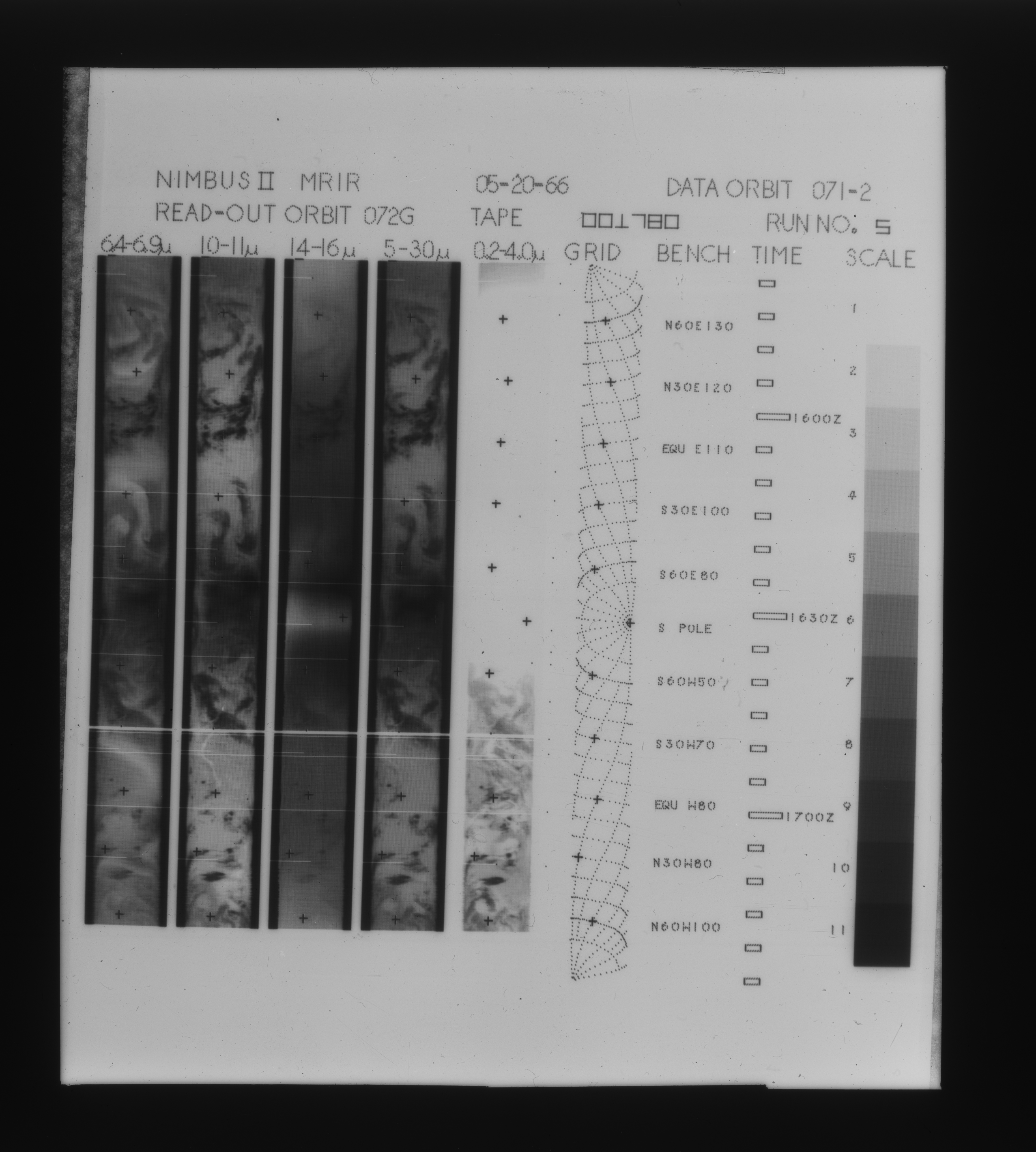
Federal
MRIR/Nimbus-2 Level 1 Meteorological Radiation Data V001 (MRIRN2L1) at GES DISC
National Aeronautics and Space Administration —
The Nimbus 2 Medium Resolution Infrared Radiometer (MRIR) was designed to measure electromagnetic radiation emitted and reflected from the earth and its atmosphere at...

Official websites use .gov
A
.gov website belongs to an official government
organization in the United States.
Secure .gov websites use HTTPS
A
lock (
) or https:// means you’ve safely connected to
the .gov website. Share sensitive information only on official,
secure websites.