
-
Federal
2023 National Offshore Wind data set (NOW-23)
Department of Energy —
The 2023 National Offshore Wind data set (NOW-23) is the latest wind resource data set for offshore regions in the United States, which supersedes, for its offshore... -
Federal
UAV image and ground data of two citrus 'Valencia' orange (<i>Citrus</i> sinensis [L.] Osbeck) rootstock trials
Department of Agriculture —
The data are UAV (Unmanned Aerial Vehicle) and individual tree ground measurements collected from 2 citrus rootstock trials at the U.S. Horticultural Research... -
Federal
BSEE Data Center - Geographic Mapping Data in Digital Format
Department of the Interior —
The geographic data are built from the Technical Information Management System (TIMS). TIMS consists of two separate databases: an attribute database and a spatial... -
Federal
NACP North American Forest Dynamics Project: Forest Disturbance and Regrowth Data
National Aeronautics and Space Administration —
This data set provides the results of time-series analyses of Landsat imagery for 55 selected forested sites across the conterminous U.S.A. The output is a pair of... -
Federal
United States Offshore Wind Supply Curves 2024
Department of Energy —
This data packet contains supply curves, hourly generation profiles, and composite siting exclusion TIFFs for offshore wind (OSW) in the waters of the EEZ off the... -
Federal
Hardware-in-the-loop Laboratory Performance Verification of Flexible Building Equipment in a Typical Commercial Building: Performance of Heating, Ventilation, and Air Conditioning and Thermal Energy Storage Across the United States
Department of Commerce —
This high-fidelity dataset measures the holistic load flexibility performance of a suite of commonly used commercial building heating, ventilating, and air-... -
Federal
Optical scattering measurements and simulation data for one-dimensional (1-D) patterned periodic sub-wavelength features
National Institute of Standards and Technology —
This data set consists of both measured and simulated optical intensities scattered off periodic line arrays, with simulations based upon an average geometric model... -
Federal
Global 1-km Gridded Thickness of Soil, Regolith, and Sedimentary Deposit Layers
National Aeronautics and Space Administration —
This data set provides high-resolution estimates of the thickness of the permeable layers above bedrock (soil, regolith, and sedimentary deposits) within a global... -
Federal
Daymet: Daily Surface Weather Data on a 1-km Grid for North America, Version 4 R1
National Aeronautics and Space Administration —
This dataset provides Daymet Version 4 R1 data as gridded estimates of daily weather parameters for North America, Hawaii, and Puerto Rico. Daymet variables include... -
Federal
UNH TDP - Concurrent Measurements of Inflow, Power Performance, and Loads for a Grid-Synchronized Vertical Axis Cross-Flow Turbine Operating in a Tidal Estuary
Department of Energy —
This data was collected between October 12 and December 15 of 2021 at the University of New Hampshire (UNH) and Atlantic Marine Energy Center (AMEC) turbine... -
Federal
ECOSTRESS Gridded Downscaled Meteorology Instantaneous L3 Global 70 m V002
National Aeronautics and Space Administration —
The ECOsystem Spaceborne Thermal Radiometer Experiment on Space Station (ECOSTRESS) mission measures the temperature of plants to better understand how much water... -
Federal
A Materials Properties Dataset for Elastomeric Foam Impact Mitigating Materials
Department of Commerce —
The database includes mechanical data for structure-properties relationships and mechanical modeling of elastic impact protection foams from a variety of imaging... -
Federal
UAV image and ground data of citrus 'Bingo' mandarin hybrid (<i>Citrus </i>reticulata, Blanco) rootstock trial
Department of Agriculture —
The data are UAV ( (Unmanned Aerial Vehicle) and individual tree ground measurements collected in 2021 of 206 trees that were part of a citrus rootstock trial at the... -
Federal
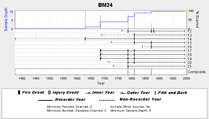
NOAA/WDS Paleoclimatology - Veblen fire data from BM24 - IMPD USBM-024
National Oceanic and Atmospheric Administration, Department of Commerce —
This archived Paleoclimatology Study is available from the NOAA National Centers for Environmental Information (NCEI), under the World Data Service (WDS) for... -
Federal
Sentinel-5P TROPOMI Tropospheric Formaldehyde HCHO 1-Orbit L2 7km x 3.5km V1 (S5P_L2__HCHO__) at GES DISC
National Aeronautics and Space Administration —
Starting from August 6th in 2019, Sentinel-5P TROPOMI along-track high spatial resolution (~5.5km at nadir) has been implemented. Starting from July 13th in 2020,... -
Federal
LBA-ECO CD-10 H2O Profiles at km 67 Tower Site, Tapajos National Forest
National Aeronautics and Space Administration —
This data set reports vertical profiles of H2O vapor concentrations measured at the Para Western (Santarem) - km 67, Primary Forest Tower Site (Figure 1). This site... -
Federal
CERES and GEO-Enhanced TOA, Within-Atmosphere and Surface Fluxes, Clouds and Aerosols 1-Hourly Terra-Aqua-NOAA20 Edition4B
National Aeronautics and Space Administration —
CER_SYN1deg-1Hour_Terra-Aqua-NOAA20_Edition4B is the Clouds and the Earth's Radiant Energy System (CERES) and geostationary (GEO) Top-of-Atmosphere (TOA) Within-... -
Federal
Carbon Monitoring System Lake Superior Primary Production Yearly V1 (CMSLakeSuperiorPPY) at GES DISC
National Aeronautics and Space Administration —
Yearly Average primary production/carbon fixation data for Lake Superior. The primary production data is derived using MODIS imagery with model data.The NASA Carbon... -
Federal
Pre-Delta-X: Total Suspended Solids of Surface Water across MRD, LA, USA, 2015-2016
National Aeronautics and Space Administration —
This dataset contains the total suspended solids (TSS) concentration of in situ water samples collected at selected sites across the Atchafalaya and Terrebonne Basins... -
Federal
Sounder SIPS: JPSS-1 CrIS Level 3 Specific Quality Control Gridded Daily CLIMCAPS V2 (SNDRJ1IML3SDCCP) at GES DISC
National Aeronautics and Space Administration —
WARNING: To users of the derived product “co_mmr_midtrop” (carbon monoxide mass mixing ratio to dry air [kg/kg] at ~500 hPa). This variable has a significant bias due...

Official websites use .gov
A
.gov website belongs to an official government
organization in the United States.
Secure .gov websites use HTTPS
A
lock (
) or https:// means you’ve safely connected to
the .gov website. Share sensitive information only on official,
secure websites.