
-
Federal
2023 National Offshore Wind data set (NOW-23)
Department of Energy —
The 2023 National Offshore Wind data set (NOW-23) is the latest wind resource data set for offshore regions in the United States, which supersedes, for its offshore... -
County
Housing Market Value Analysis - Allegheny County Economic Development
Allegheny County / City of Pittsburgh / Western PA Regional Data Center —
In 2017, the County Department of Economic Development, in conjunction with Reinvestment Fund, completed the 2016 Market Value Analysis (MVA) for Allegheny County. A... -
Federal
A Materials Properties Dataset for Elastomeric Foam Impact Mitigating Materials
Department of Commerce —
The database includes mechanical data for structure-properties relationships and mechanical modeling of elastic impact protection foams from a variety of imaging... -
Federal
NASA Ocean Biogeochemical Model assimilating satellite chlorophyll data global monthly VR2017 (NOBM_MON) at GES DISC
National Aeronautics and Space Administration —
This is the assimilated monthly data from NASA Ocean Biogeochemical Model (NOBM). The NOBM is a comprehensive, interactive ocean biogeochemical model coupled with a... -
Federal
EMIT L4 Earth System Model Products V001
National Aeronautics and Space Administration —
The Earth Surface Mineral Dust Source Investigation (EMIT) instrument measures surface mineralogy, targeting the Earth’s arid dust source regions. EMIT is installed... -
Federal
Risk Factor Analysis in Low-Temperature Geothermal Play Fairway Analysis for the Appalachian Basin (GPFA-AB)
Department of Energy —
This submission contains information used to compute the risk factors for the GPFA-AB project. The risk factors are natural reservoir quality, thermal resource... -
Federal
Experimental Measurements for Fire Model Validation - Parallel Panel Tests on PMMA
National Institute of Standards and Technology —
A set of 6 experiments was performed on poly(methyl methacrylate), PMMA. In each test, samples (i.e., 2.44 m tall, 0.61 m wide slabs of PMMA mounted in a parallel... -
Federal
Global Gridded Surfaces of Selected Soil Characteristics (IGBP-DIS)
National Aeronautics and Space Administration —
The Global Gridded Surfaces of Selected Soil Characteristics (IGBP-DIS) data set contains 7 data surfaces: soil-carbon density, total nitrogen density, field... -
Federal
A Materials Properties Dataset for Elastomeric Foam Impact Mitigating Materials
National Institute of Standards and Technology —
The database includes mechanical data for structure-properties relationships and mechanical modeling of elastic impact protection foams from a variety of imaging... -
Federal
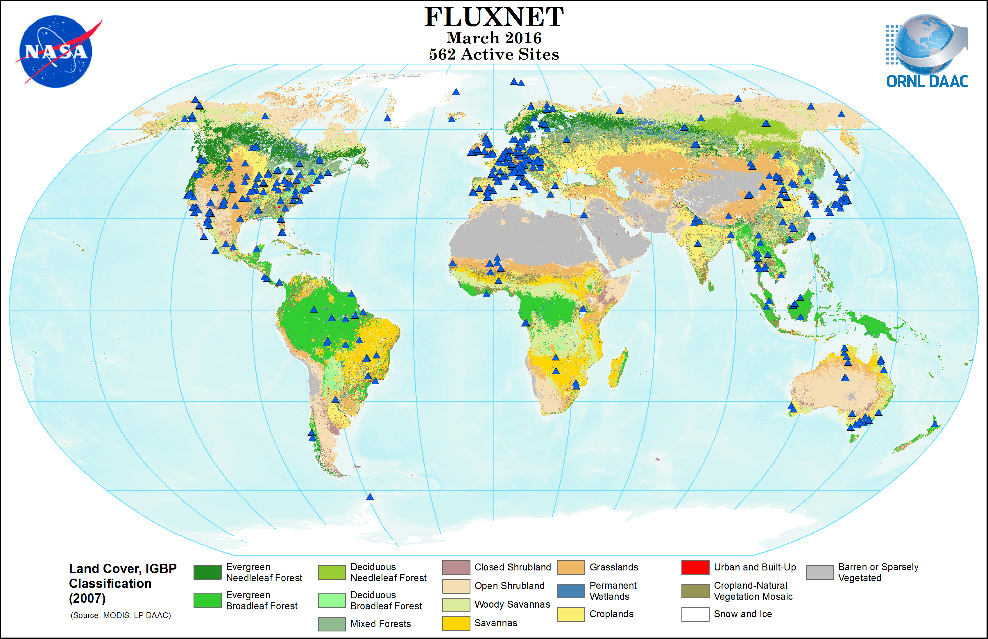
FLUXNET Research Network Site Characteristics, Investigators, and Bibliography, 2016
National Aeronautics and Space Administration —
FLUXNET is a global network of micrometeorological tower sites that use eddy covariance methods to measure the exchanges of carbon dioxide, water vapor, and energy... -
Federal
EMIT L2B Estimated Mineral Identification and Band Depth and Uncertainty 60 m V001
National Aeronautics and Space Administration —
The Earth Surface Mineral Dust Source Investigation (EMIT) instrument measures surface mineralogy, targeting the Earth’s arid dust source regions. EMIT is installed... -
Federal
VEMAP 2: U.S. Monthly Climate, 1895-1993, Version 2
National Aeronautics and Space Administration —
The Vegetation/Ecosystem Modeling and Analysis Project (VEMAP) Phase 2 has developed a data set of ~100-year gridded monthly and daily time series of climate for the... -
Federal
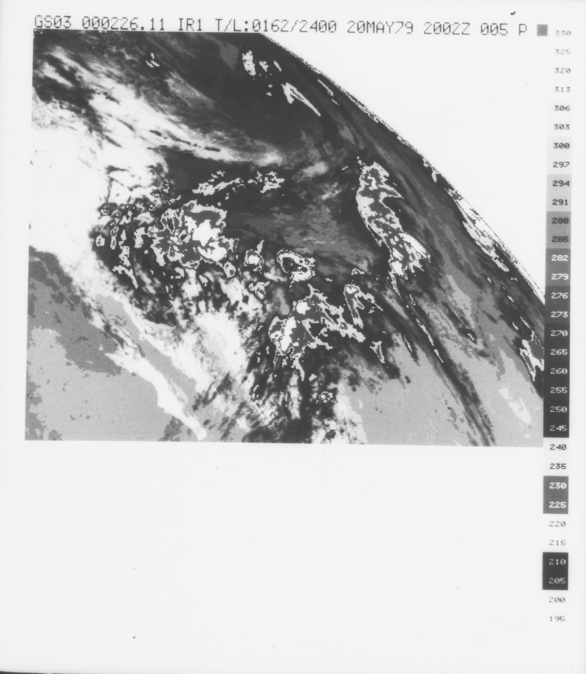
VISSR/GOES-3 Infrared Imagery on 70mm Film V001 (VISSRGOES3IMIR) at GES DISC
National Aeronautics and Space Administration —
VISSRGOES3IMIR is the Visible Infrared Spin-Scan Radiometer (VISSR) Infrared Imagery on 70mm Film data product from the third Geostationary Operational Environmental... -
Federal
TransCom 3: Annual Mean CO2 Flux Estimates from Atmospheric Inversions (Level 1)
National Aeronautics and Space Administration —
The Atmospheric Tracer Transport Model Intercomparison Project (TransCom) was created to quantify and diagnose the uncertainty in inversion calculations of the global... -
Federal
SiB3 Modeled Global 1-degree Hourly Biosphere-Atmosphere Carbon Flux, 1998-2006
National Aeronautics and Space Administration —
The Simple Biosphere Model, Version 3 (SiB3) was used to produce a global data set of hourly carbon fluxes between the atmosphere and the terrestrial biosphere for... -
Federal
SORCE Combined XPS, SOLSTICE, and SIM Solar Spectral Irradiance 24-Hour Means V001 (SOR3D_COMBINED_001) at GES DISC
National Aeronautics and Space Administration —
The SORCE Combined XPS, SOLSTICE, and SIM Solar Spectral Irradiance 24-Hour Means product consists of daily averages of the solar spetra from 0.1 to 2412 nm. The... -
Federal
MLS/Aura Level 3 Monthly Binned Nitric Acid (HNO3) Mixing Ratio on Assorted Grids V005 (ML3MBHNO3) at GES DISC
National Aeronautics and Space Administration —
ML3MBHNO3 is the EOS Aura Microwave Limb Sounder (MLS) monthly binned on various vertical grids product for nitric acid (HNO3) derived from radiances measured by the... -
Federal
VEMAP 2: U.S. Monthly Climate Change Scenarios, Version 2
National Aeronautics and Space Administration —
The Vegetation/Ecosystem Modeling and Analysis Project (VEMAP) Phase 2 has developed a number of transient climate change scenarios based on coupled atmosphere-ocean... -
Federal
LPJ-PROSAIL L2 Global Simulated Dynamic Surface Reflectance V002
National Aeronautics and Space Administration —
LPJ-PROSAIL simulated data products are produced through the coupling of the Lund-Potsdam-Jena dynamic global vegetation model (LPJ) and PROSAIL, a radiative transfer...

Official websites use .gov
A
.gov website belongs to an official government
organization in the United States.
Secure .gov websites use HTTPS
A
lock (
) or https:// means you’ve safely connected to
the .gov website. Share sensitive information only on official,
secure websites.