
-
Federal
Endangered Species Act recent views
National Oceanic and Atmospheric Administration, Department of Commerce —
The purpose of the Endangered Species Act (ESA) is to protect and recover imperiled species and the ecosystems upon which they depend. The U.S. Fish and Wildlife... -
Federal
Chesapeake Bay and the Outer Coasts of Maryland and Virginia 2016 ESI BENTHIC Polygons recent views
National Oceanic and Atmospheric Administration, Department of Commerce —
This data set contains sensitive biological resource data for submerged aquatic vegetation (SAV) in Chesapeake Bay and the Outer Coasts of Maryland and Virginia.... -
Federal
Critical Habitat by USFWS recent views
National Oceanic and Atmospheric Administration, Department of Commerce —
When a species is proposed for listing as endangered or threatened under the Endangered Species Act, the U.S. Fish and Wildlife Service must consider whether there... -
Federal
NOAA NGS Continually Updated Shoreline Product (CUSP) recent views
National Oceanic and Atmospheric Administration, Department of Commerce —
These data provide available contemporary high-resolution national shoreline. The Continually Updated Shoreline Product is provided via the National Shoreline Data... -
Federal
National Coral Reef Monitoring Program: Assessment of coral reef fish communities in Puerto Rico recent views
National Oceanic and Atmospheric Administration, Department of Commerce —
Data provided in this collection were gathered around Puerto Rico as part of NCCOS-led missions in collaboration with partners at U.S. Fish and Wildlife Service,... -
Federal
Georgia 2015 ESI BIRD Polygons, Points recent views
National Oceanic and Atmospheric Administration, Department of Commerce —
This feature class resides within the BIOLOGY Feature Data Set of the Georgia - 2015 ESI Geodatabase. It contains sensitive biological resource data for wading birds,... -
Federal
BLM Natl USDOI FWS GRSG Greater Sage-Grouse Conservation Objectives Final Report recent views
Department of the Interior —
The U.S. Fish and Wildlife Service (Service) is making available a final report that is designed to help guide the efforts of the States and other partners to... -
Federal
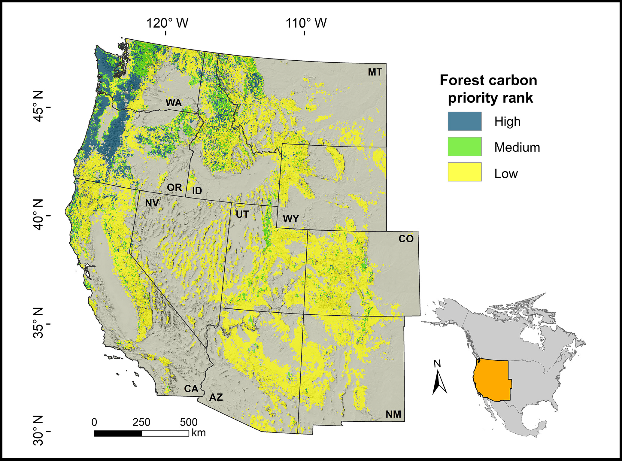
Forest Preservation Ranking and Vertebrate Species Richness, Western USA, 2020-2099 recent views
National Aeronautics and Space Administration —
This dataset provides related gridded outputs of future modeled forest carbon sequestration priority and related species richness and habitat suitability for the... -
Federal
Shoreline surveys and removal of marine debris at Midway Atoll, Northwestern Hawaiian Islands from 2013 to 2016 (NCEI Accession 0189571) recent views
National Oceanic and Atmospheric Administration, Department of Commerce —
The marine debris data included in this dataset are from annual shoreline surveys conducted from 2013 to 2016 at the islands of Midway Atoll (Eastern, Spit, and Sand... -
Federal
Maps of Shallow-water Banks in the Northwestern Hawaiian Islands Derived from Moderate Resolution Landsat Satellite Imagery recent views
National Oceanic and Atmospheric Administration, Department of Commerce —
Shallow-water (generally, less than 30 meters) bank areas in the Northwestern Hawaiian Islands were identified using semi-automated image analysis of Landsat 7 ETM+... -
Federal
Aggregated Habitat Cover Maps Depicting the Shallow-water Benthic Habitats of the Northwestern Hawaiian Islands Derived from High Resolution IKONOS Satellite Imagery recent views
National Oceanic and Atmospheric Administration, Department of Commerce —
Shallow-water, aggregated cover maps were produced by combining as many as four or more detailed habitat types into general cover categories. The original detailed... -
Federal
Detailed Maps Depicting the Shallow-Water Benthic Habitats of the Northwestern Hawaiian Islands Derived from High Resolution IKONOS Satellite Imagery recent views
National Oceanic and Atmospheric Administration, Department of Commerce —
Detailed, shallow-water coral reef ecosystem maps were generated by rule-based, semi-automated image analysis of high-resolution satellite imagery for nine locations... -
Federal
Bioeffects Assessment in Kvichak and Nushagak Bay, Alaska: Characterization of Soft Bottom Benthic Habitats, Fish Body Burdens and Contaminant Baseline Assessment recent views
National Oceanic and Atmospheric Administration, Department of Commerce —
The goal of this project is to assess habitat conditions that influence biodiversity and distribution of benthic infaunal communities, contaminants, and chemical body... -
Federal
Integrated ecosystem assessment of Vieques, Puerto Rico Benthic Composition Assessment and Monitoring Data recent views
National Oceanic and Atmospheric Administration, Department of Commerce —
This fish and benthic composition database is the result of a multifaceted effort described below.The National Oceanic and Atmospheric Administration's (NOAA)... -
Federal
Estimated Depth Maps of the Northwestern Hawaiian Islands Derived from High Resolution IKONOS Satellite Imagery recent views
National Oceanic and Atmospheric Administration, Department of Commerce —
Estimated shallow-water, depth maps were produced using rule-based, semi-automated image analysis of high-resolution satellite imagery for nine locations in the... -
Federal
Southwest Peninsular Florida 2016 ESI REPTILE & AMPHIBIAN Polygons recent views
National Oceanic and Atmospheric Administration, Department of Commerce —
This data set contains sensitive biological resource data for turtles, snakes, alligators, and crocodiles in Southwest Florida. Vector polygons in this data set... -
Federal
Outer Coast of Washington and Oregon 2014 ESI BIRD Polygons, Lines, Points recent views
National Oceanic and Atmospheric Administration, Department of Commerce —
This data set contains sensitive biological resource data for alcids, diving birds, gulls and terns, passerine birds, pelagic birds, raptors, shorebirds, wading... -
Federal
Integrated ecosystem assessment of Vieques, Puerto Rico Fish Assessment and Monitoring Data recent views
National Oceanic and Atmospheric Administration, Department of Commerce —
This fish and benthic composition database is the result of a multifaceted effort described below.The National Oceanic and Atmospheric Administration's (NOAA)... -
Federal
Outer Coast of Washington and Oregon 2014 ESI FISH Polygons, Lines recent views
National Oceanic and Atmospheric Administration, Department of Commerce —
This data set contains sensitive biological resource data for marine, estuarine, anadromous, diadromous, and freshwater fish species for the Outer Coast of Washington... -
Federal
South Carolina 2015 ESI REPTILE & AMPHIBIAN Polygons recent views
National Oceanic and Atmospheric Administration, Department of Commerce —
This data set contains sensitive biological resource data for sea turtles, diamondback terrapin, eastern diamondback rattlesnake (state species of concern), and...

Official websites use .gov
A
.gov website belongs to an official government
organization in the United States.
Secure .gov websites use HTTPS
A
lock (
) or https:// means you’ve safely connected to
the .gov website. Share sensitive information only on official,
secure websites.