
-
Federal
Gridded Population of the World, Version 4 (GPWv4): Population Count, Revision 11
National Aeronautics and Space Administration —
The Gridded Population of the World, Version 4 (GPWv4): Population Count, Revision 11 consists of estimates of human population (number of persons per pixel),... -
Federal
Poverty Mapping Project: Poverty and Food Security Case Studies
National Aeronautics and Space Administration —
The Poverty Mapping Project: Poverty and Food Security Case Studies data set consists of small area estimates of poverty, inequality, food security and related... -
Federal
Gridded Population of the World, Version 4 (GPWv4): Population Density, Revision 11
National Aeronautics and Space Administration —
The Gridded Population of the World, Version 4 (GPWv4): Population Density, Revision 11 consists of estimates of human population density (number of persons per... -
Federal
Poverty Mapping Project: Small Area Estimates of Poverty and Inequality
National Aeronautics and Space Administration —
The Poverty Mapping Project: Small Area Estimates of Poverty and Inequality data set consists of consumption-based poverty, inequality and related measures for... -
Federal
Gridded Population of the World, Version 3 (GPWv3): National Administrative Boundaries
National Aeronautics and Space Administration —
The Gridded Population of the World, Version 3 (GPWv3): National Administrative Boundaries are derived from the land area grid to show the outlines of pixels (cells)... -
Federal
Latin America and the Caribbean Population Time Series
National Aeronautics and Space Administration —
The Latin America and the Caribbean Population Time Series data set provides total population estimates using spatially consistent and comparable Units for Latin... -
Federal
Gridded Population of the World, Version 3 (GPWv3): Population Density Grid
National Aeronautics and Space Administration —
The Gridded Population of the World, Version 3 (GPWv3): Population Density Grid consists of estimates of human population for the years 1990, 1995, and 2000 by 2.5... -
Federal
Gridded Population of the World, Version 4 (GPWv4): Population Density Adjusted to Match 2015 Revision UN WPP Country Totals, Revision 11
National Aeronautics and Space Administration —
The Gridded Population of the World, Version 4 (GPWv4): Population Density Adjusted to Match 2015 Revision of UN WPP Country Totals, Revision 11 consists of estimates... -
Federal
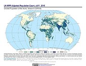
Gridded Population of the World, Version 4 (GPWv4): Population Count Adjusted to Match 2015 Revision of UN WPP Country Totals, Revision 11
National Aeronautics and Space Administration —
The Gridded Population of the World, Version 4 (GPWv4): Population Count Adjusted to Match 2015 Revision of UN WPP Country Totals, Revision 11 consists of estimates... -
Federal
Global Rural-Urban Mapping Project, Version 1 (GRUMPv1): National Administrative Boundaries
National Aeronautics and Space Administration —
The Global Rural-Urban Mapping Project, Version 1 (GRUMPv1): National Administrative Boundaries are derived from the land area grid to show the outlines of pixels... -
Federal
Gridded Population of the World, Version 3 (GPWv3): Population Count Grid, Future Estimates
National Aeronautics and Space Administration —
The Gridded Population of the World, Version 3 (GPWv3): Population Count Grid, Future Estimates consists of estimates of human population for the years 2005, 2010,... -
Federal
West Africa Coastal Vulnerability Mapping: GPW Version 4 Population Density, Preliminary Release 1, 2010
National Aeronautics and Space Administration —
The West Africa Coastal Vulnerability Mapping: GPW Version 4 Population Density, Preliminary Release 1, 2010, represents the number of persons per square kilometer,... -
Federal
Gridded Population of the World, Version 3 (GPWv3): Population Density Grid, Future Estimates
National Aeronautics and Space Administration —
The Gridded Population of the World, Version 3 (GPWv3): Population Density Grid, Future EstimatesFuture Estimates consists of estimates of human population for the... -
Federal
Global Volcano Total Economic Loss Risk Deciles
National Aeronautics and Space Administration —
Global Volcano Total Economic Loss Risk Deciles is a 2.5 minute grid of global volcano total economic loss risks. First, subnational distributions of Gross Domestic... -
Federal
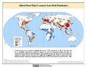
Global Flood Total Economic Loss Risk Deciles
National Aeronautics and Space Administration —
The Global Flood Total Economic Loss Risk Deciles is a 2.5 minute grid of global flood total economic loss risks. A process of spatially allocating Gross Domestic... -
Federal
Gridded Population of the World, Version 3 (GPWv3): Centroids
National Aeronautics and Space Administration —
The Gridded Population of the World, Version 3 (GPWv3): Centroids consists of estimates of human population counts and densities for the years 1990, 1995, 2000, 2005,... -
Federal
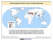
Global Earthquake Total Economic Loss Risk Deciles
National Aeronautics and Space Administration —
The Global Earthquake Total Economic Loss Risk Deciles is a 2.5 minute grid of global earthquake total economic loss risks. A process of spatially allocating Gross... -
Federal
Global Rural-Urban Mapping Project, Version 1 (GRUMPv1): Coastlines
National Aeronautics and Space Administration —
The Global Rural-Urban Mapping Project, Version 1 (GRUMPv1): Coastlines data are derived from the land area grids to show the outlines of pixels (cells) that contain... -
Federal
West Africa Coastal Vulnerability Mapping: GPW Version 4 Population Growth, Preliminary Release 1, 2000-2010
National Aeronautics and Space Administration —
The West Africa Coastal Vulnerability Mapping: GPW Version 4 Population Growth, Preliminary Release 1, 2000-2010, represents positive or negative growth in the number...

Official websites use .gov
A
.gov website belongs to an official government
organization in the United States.
Secure .gov websites use HTTPS
A
lock (
) or https:// means you’ve safely connected to
the .gov website. Share sensitive information only on official,
secure websites.