
-
Federal
VEMAP 2: Annual Ecosystem Model Responses to U.S. Climate Change, 1994-2100 recent views
National Aeronautics and Space Administration —
Phase 2 of the VEMAP Project developed historical (1895-1993) gridded data sets of climate (temperature, precipitation, solar radiation, humidity, and wind speed) and... -
Federal
A Global Database of Gas Fluxes from Soils after Rewetting or Thawing, Version 1.0 recent views
National Aeronautics and Space Administration —
This database contains information compiled from published studies on gas flux from soil following rewetting or thawing. The resulting database includes 222 field and... -
Federal
Global Fire Emissions Database, Version 4.1 (GFEDv4) NGDA recent views
National Aeronautics and Space Administration —
This dataset provides global estimates of monthly burned area, monthly emissions and fractional contributions of different fire types, daily or 3-hourly fields to... -
Federal
Global Forest Ecosystem Structure and Function Data For Carbon Balance Research recent views
National Aeronautics and Space Administration —
A comprehensive global database has been assembled to quantify CO2 fluxes and pathways across different levels of integration (from photosynthesis up to net ecosystem... -
Federal
ISLSCP II Ecosystem Rooting Depths NGDA recent views
National Aeronautics and Space Administration —
The goal of this study was to predict the global distribution of plant rooting depths based on data about global aboveground vegetation structure and climate.... -
Federal
ATom: Merged Atmospheric Chemistry, Trace Gases, and Aerosols recent views
National Aeronautics and Space Administration —
This dataset provides information on greenhouse gases and human-produced air pollution, including atmospheric concentrations of carbon dioxide (CO2), methane (CH4),... -
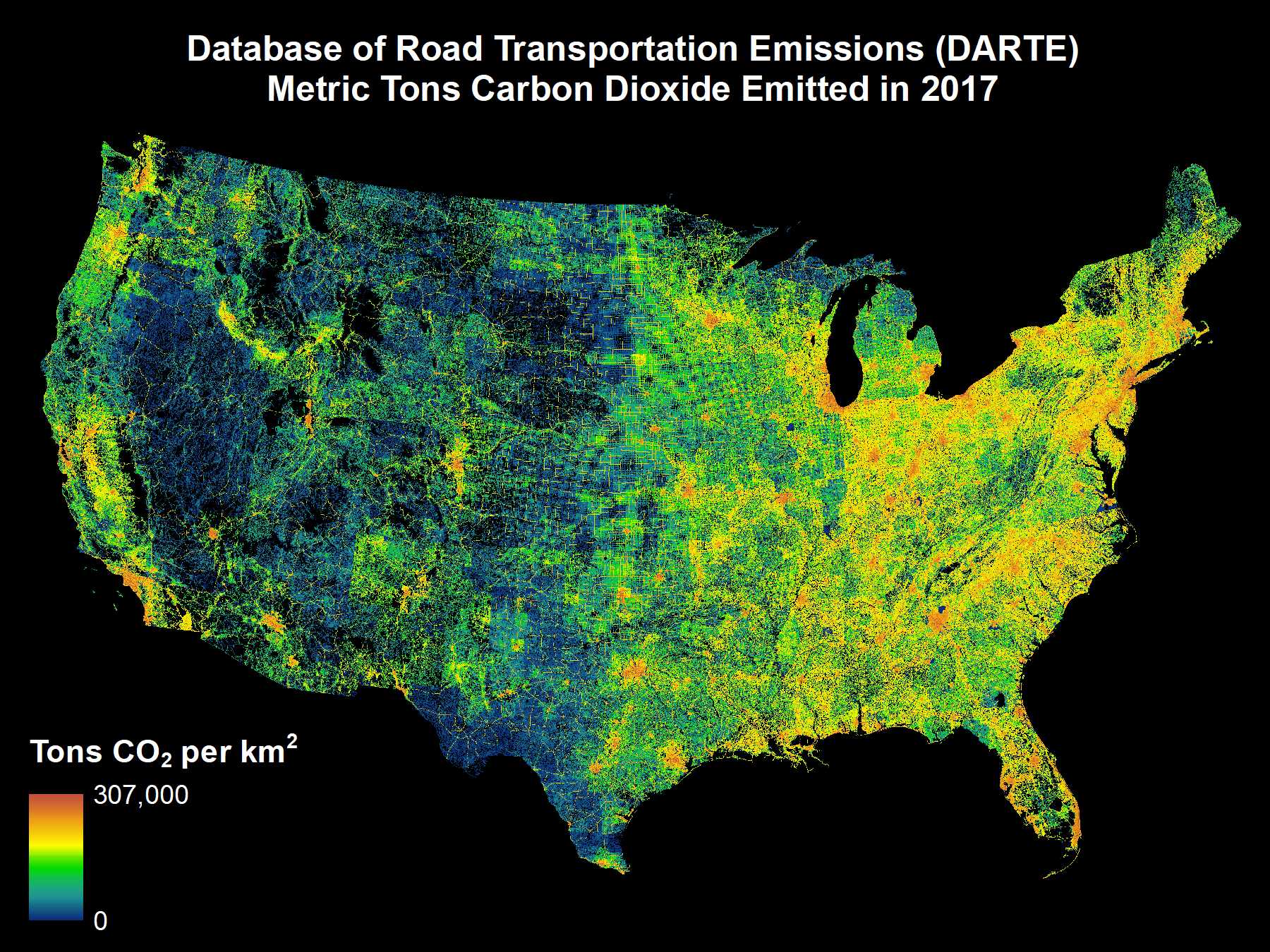
Federal
DARTE Annual On-road CO2 Emissions on a 1-km Grid, Conterminous USA, V2, 1980-2017 recent views
National Aeronautics and Space Administration —
This data set provides a 38-year, 1-km resolution inventory of annual on-road CO2 emissions for the conterminous United States based on roadway-level vehicle traffic... -
Federal
Methane Emissions from Dairy Sources (Vista-CA), State of California, USA, 2019 recent views
National Aeronautics and Space Administration —
This dataset provides estimates of methane (CH4) emissions from dairies in California at a resolution of 0.1 degrees (~ 10 km x 10 km) for the year 2019. The mapped... -
Federal
ATom: L2 Measurements from CU High-Resolution Aerosol Mass Spectrometer (HR-AMS) recent views
National Aeronautics and Space Administration —
This dataset provides the atmospheric concentrations of separated ions from inorganic and organic species measured by the High-Resolution Aerosol Mass Spectrometer... -
Federal
Land Surface Model (LSM 1.0) for Ecological, Hydrological, Atmospheric Studies recent views
National Aeronautics and Space Administration —
The NCAR LSM 1.0 is a land surface model developed to examine biogeophysical and biogeochemical land-atmosphere interactions, especially the effects of land surfaces... -
Federal
ISLSCP II Air-Sea Carbon Dioxide Gas Exchange recent views
National Aeronautics and Space Administration —
This data set contains the calculated net ocean-air carbon dioxide (CO2) flux and sea-air CO2 partial pressure (pCO2) difference. The estimates are based on... -
Federal
SAFARI 2000 GPCP Daily Precipitation, 1-Deg, 1999-2001 recent views
National Aeronautics and Space Administration —
The Global Precipitation Climatology Project (GPCP) is an international project designed to provide improved long-record estimates of precipitation over the globe.... -
Federal
ATom: Data Stream for Modeling the Reactivity of ATom Air Parcels, 2016-2018 recent views
National Aeronautics and Space Administration —
This dataset provides Modeling Data Stream (MDS) and Reactivity Data Stream (RDS) products for each of the four ATom campaigns conducted from 2016 to 2018. MDS files... -
Federal
Sources of Methane Emissions (Vista-CA), State of California, USA recent views
National Aeronautics and Space Administration —
This dataset provides spatial data products with identified and organized locations of potential methane (CH4) emitting facilities and infrastructure spanning the... -
Federal
Daily Rainfall Data (FIFE) recent views
National Aeronautics and Space Administration —
Daily rainfall data, by site & date -
Federal
ISLSCP II Globalview: Atmospheric CO2 Concentrations recent views
National Aeronautics and Space Administration —
The GlobalView Carbon Dioxide (CO2) data product contains synchronized and smoothed time series of atmospheric CO2 concentrations at selected sites that were created... -
Federal
30 Minute Rainfall Data (FIFE) recent views
National Aeronautics and Space Administration —
30 minute rainfall data for the Konza Prairie -
Federal
Daymet: Monthly Climate Summaries on a 1-km Grid for North America, Version 4 R1 recent views
National Aeronautics and Space Administration —
This dataset provides Daymet Version 4 R1 monthly climate summaries derived from Daymet Version 4 R1 daily data at a 1 km x 1 km spatial resolution for five Daymet... -
Federal
Methane Plumes Derived from AVIRIS-NG over Point Sources across California, 2016-2017 recent views
National Aeronautics and Space Administration —
This dataset provides maps of methane (CH4) plumes along flight lines over identified methane point-source emitting infrastructure across the State of California, USA... -
Federal
BOREAS AFM-06 Boundary Layer Height Data recent views
National Aeronautics and Space Administration —
Contains AFM-06 hourly inversion height measurements.

Official websites use .gov
A
.gov website belongs to an official government
organization in the United States.
Secure .gov websites use HTTPS
A
lock (
) or https:// means you’ve safely connected to
the .gov website. Share sensitive information only on official,
secure websites.