
-
Federal
RLC State and Regional Boundaries for the Former Soviet Union
National Aeronautics and Space Administration —
This data set of state and regional boundaries was derived from the 1:3 million scale administrative boundaries (ESRI, 1998) for the land area of the Former Soviet... -
Federal
NACP Regional: National Greenhouse Gas Inventories and Aggregated Gridded Model Data
National Aeronautics and Space Administration —
This data set provides two products that were derived from the recently published North American Carbon Program (NACP) Regional Synthesis 1-degree terrestrial... -
Federal
Aircraft Flux-Filtered: U of Wy. (FIFE)
National Aeronautics and Space Administration —
The University of Wyoming (UW) King Air atmospheric boundary layer measurement missions were flown in 1987 during IFCs 3 and 4. This Boundary Layer Fluxes data set... -
Federal
AMAZE-08 Aerosol Characterization and Meteorological Data, Central Amazon Basin: 2008
National Aeronautics and Space Administration —
This data set provides measurements from the Amazonian Aerosol Characterization Experiment (AMAZE-08) carried out during the wet season from February 4 to March 21,... -
Federal
Global Soil Types, 0.5-Degree Grid (Modified Zobler)
National Aeronautics and Space Administration —
A global data set of soil types is available at 0.5-degree latitude by 0.5-degree longitude resolution. There are 106 soil units, based on Zobler?s (1986) assessment... -
Federal
Aircraft Flux-Detrended: Univ. Col. (FIFE)
National Aeronautics and Space Administration —
The NCAR King Air participation in FIFE-1987 and FIFE-1989 was part of a coordinated atmospheric boundary layer component which included other aircraft, surface... -
Federal
Annual Land Use and Urban Land Cover: Ethiopia, Nigeria, and South Africa, 2016-2020
National Aeronautics and Space Administration —
This dataset provides a two-tier annual Land Use (LU) and Urban Land Cover (LC) product suite over three African countries, Ethiopia, Nigeria, and South Africa,... -
Federal
LBA-ECO LC-04 THMB Model Simulations for the Amazon and Tocantins Basins: 1939-1998
National Aeronautics and Space Administration —
The model output data provided were generated by the THMB 1.2 (Terrestrial Hydrology Model with Biogeochemistry) model which simulates the flow of water through... -
Federal
LBA-ECO CD-06 Physical, Political, and Hydrologic Maps, Ji-Parana River Basin, Brazil
National Aeronautics and Space Administration —
This data set contains physical, hydrologic, political, demographic, and societal maps for the Ji-Parana River Basin, in the state of Rondonia, Brazil. These data... -
Federal
BOREAS AFM-03 NCAR Electra 1994 Aircraft Sounding Data
National Aeronautics and Space Administration —
The BOREAS AFM-03 team used the NCAR Electra aircraft to make sounding measurements to study the planetary boundary layer using in situ and remote-sensing... -
Federal
BOREAS AFM-04 Twin Otter Aircraft Sounding Data
National Aeronautics and Space Administration —
The BOREAS AFM-04 team used the NRC Twin Otter aircraft to make sounding measurements through the boundary layer. These measurements included concentrations of carbon... -
Federal
Atmospheric Profiles: TOVS - NOAA (FIFE)
National Aeronautics and Space Administration —
The TOVS data were acquired from NOAA/NESDIS to monitor atmospheric conditions that occurred over the FIFE study area during 1987. The TOVS data were obtained from... -
Federal
ASCENDS: Airborne CO2 LAS Retrieval, Indianapolis, IN, USA, 2014
National Aeronautics and Space Administration —
This dataset provides in situ airborne measurements of atmospheric carbon dioxide (CO2) over Indianapolis, Indiana (IN) on September 3, 2014 during the morning... -
Federal
ACT-America: Profile-based Planetary Boundary Layer Heights, Eastern USA
National Aeronautics and Space Administration —
This dataset provides profile-based estimates of the height to the top of the planetary boundary layer (PBL), also known as the atmospheric boundary layer (ABL), in... -
Federal
ABoVE: AVIRIS-3 Imaging Spectroscopy for Alaska and Canada, 2023
National Aeronautics and Space Administration —
This dataset includes L1B radiance and L2A surface reflectance imagery acquired by the Airborne Visible / Infrared Imaging Spectrometer-3 (AVIRIS-3) instrument over... -
Federal
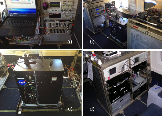
ACT-America: HALO Lidar Measurements of AOP and ML Heights, 2019
National Aeronautics and Space Administration —
This dataset provides measurements from the High Altitude Lidar Observatory (HALO) instrument, an airborne multi-function Differential Absorption Lidar (DIAL) and... -
Federal
Aircraft Flux-Detrended: NRCC (FIFE)
National Aeronautics and Space Administration —
The purpose of this study was to develop alternatives to ground-based measurements in order to obtain information required to predict the effects of soil and land use... -
Federal
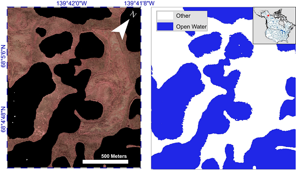
ABoVE: AirSWOT Water Masks from Color-Infrared Imagery over Alaska and Canada, 2017
National Aeronautics and Space Administration —
This dataset provides 1) a conservative open water mask for future water surface elevation (WSE) extraction from the co-registered AirSWOT Ka-band interferometry... -
Federal
Wind Profile Data: LIDAR - NOAA (FIFE)
National Aeronautics and Space Administration —
The aim of this wind profile study was to derive wind profiles and momentum fluxes from the National Oceanic and Atmospheric Administration (NOAA)/Wave Propagation... -
Federal
Pre-LBA ABLE-2A and ABLE-2B Expedition Data
National Aeronautics and Space Administration —
The ABLE 2A and 2B (Atmospheric Boundary Layer Experiments) data consists of estimates of the rate of exchange of a wide variety of aerosols and gases between the...

Official websites use .gov
A
.gov website belongs to an official government
organization in the United States.
Secure .gov websites use HTTPS
A
lock (
) or https:// means you’ve safely connected to
the .gov website. Share sensitive information only on official,
secure websites.