
-
Federal
LiDAR Surveys over Selected Forest Research Sites, Brazilian Amazon, 2008-2018
National Aeronautics and Space Administration —
This dataset provides the complete catalog of point cloud data collected during LiDAR surveys over selected forest research sites across the Amazon rainforest in... -
Federal
MAUD-Tutorial Files for "MAUD Rietveld Refinement Software for Neutron Diffraction Texture Studies of Single and Dual-Phase Materials"
National Institute of Standards and Technology —
This data set contains files included in the detailed instructional demonstration paper submitted to Integrating Materials and Manufacturing Innovation. The detailed... -
Federal
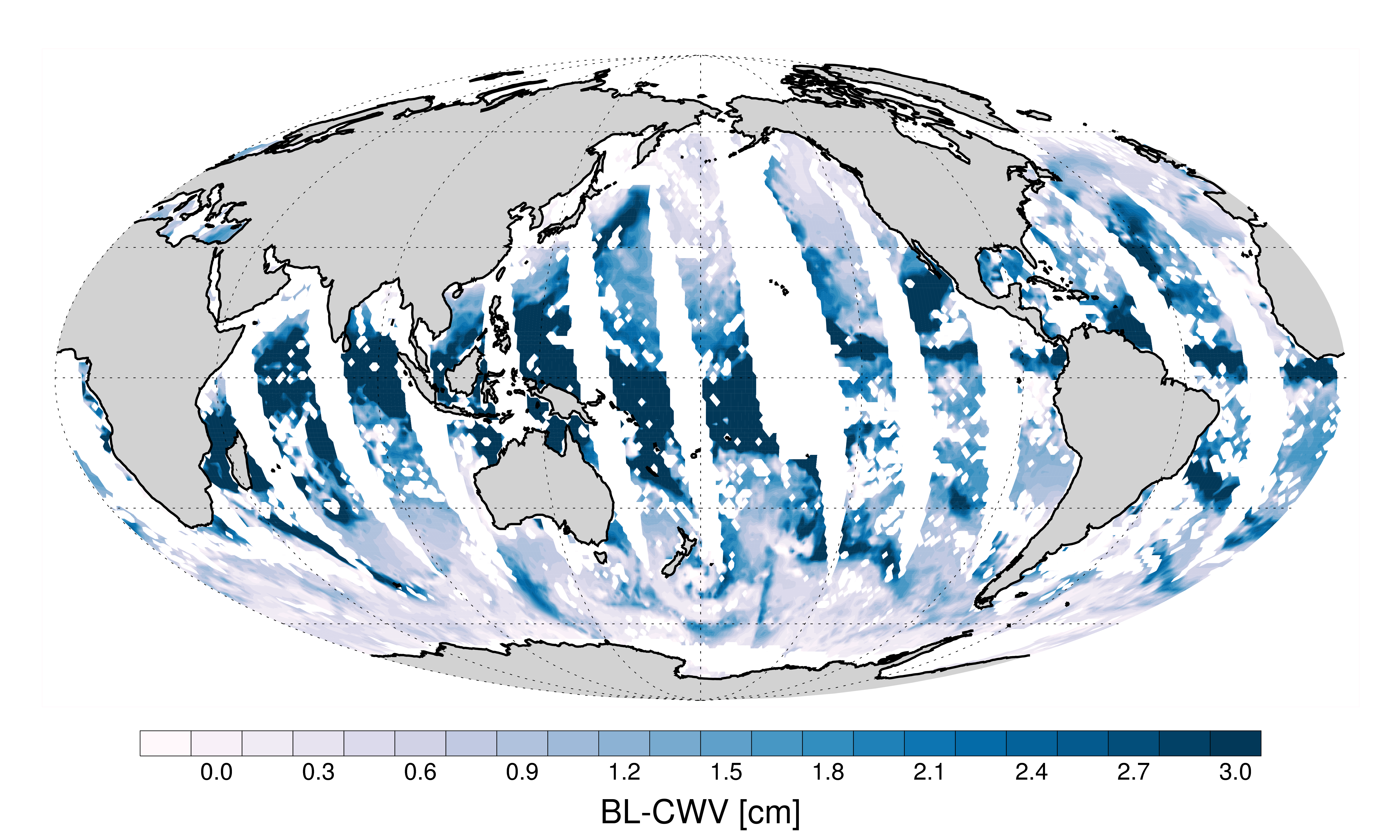
AMSR-MODIS Boundary Layer Water Vapor L3 Daily 1 degree x 1 degree V1 (AMDBLWV) at GES DISC
National Aeronautics and Space Administration —
This data set provides an estimate the marine boundary layer water vapor beneath uniform cloud fields. Microwave radiometry from AMSR-E and AMSR-2 provides the total... -
Federal
ResStock County/Household Income Assignment CHIA
Department of Energy —
These data tables are cross-tabulations that provide the distribution of households by household income, converted to Federal Poverty Level (FPL) or Area Median... -
Federal
Environmental Working Group Arctic Meteorology and Climate Atlas, Version 1
National Aeronautics and Space Administration —
The Arctic Meteorology and Climate Atlas is part of the NOAA@NSIDC Environmental Working Group (EWG) Atlases data collection.The Arctic Meteorology and Climate Atlas... -
Federal
AM Bench 2022 3D Build Modeling Challenge Description Data (AMB2022-01)
National Institute of Standards and Technology —
The following data files are provided in support of the 2022 Additive Manufacturing Benchmark test series (AM-Bench 2022) modeling challenges associated with laser... -
Federal
BOREAS TE-09 Leaf Biochemistry Averages
National Aeronautics and Space Administration —
The BOREAS TE-09 team collected several data sets related to chemical and photosynthetic properties of leaves. This data set contains canopy biochemistry data... -
Federal
X-Ray Selected High-z AGN Catalog
National Aeronautics and Space Administration —
This table contains the results from an analysis of the largest high-redshift (z > 3) X-ray-selected active galactic nucleus (AGN) sample to date, combining the... -
Federal
Global Mean Sea Level Trend from Integrated Multi-Mission Ocean Altimeters TOPEX/Poseidon, Jason-1, OSTM/Jason-2, Jason-3, and Sentinel-6 Version 5.2
National Aeronautics and Space Administration —
This dataset contains the Global Mean Sea Level (GMSL) trend generated from the Integrated Multi-Mission Ocean Altimeter Data for Climate Research Version 5.2. The... -
Federal
MODIS/Aqua Surface Reflectance 8-Day L3 Global 250m SIN Grid V061
National Aeronautics and Space Administration —
The MYD09Q1 Version 6.1 product provides an estimate of the surface spectral reflectance of Aqua Moderate Resolution Imaging Spectroradiometer (MODIS) Bands 1 and 2,... -
Federal
GEDI L2A Elevation and Height Metrics Data Global Footprint Level V002
National Aeronautics and Space Administration —
The Global Ecosystem Dynamics Investigation (GEDI) mission aims to characterize ecosystem structure and dynamics to enable radically improved quantification and... -
Federal
Process-structure-properties investigations for laser powder bed fused IN718 in the as-built condition
Department of Commerce —
This data repository provides a central location for a body of work using one build of nickel-based alloy 718 (IN718) material and resulted in three different... -
Federal
TIC (TESS Input Catalog ConeSearch)
National Aeronautics and Space Administration —
The TESS Input Catalog is a comprehensive collection of 1.73 billion sources on the sky, providing stellar parameters for evaluation of potential planetary transit... -
Federal
NLDAS Mosaic Land Surface Model L4 Hourly 0.125 x 0.125 degree V2.0 (NLDAS_MOS0125_H) at GES DISC
National Aeronautics and Space Administration —
This data set contains thirty-eight fields simulated from the Mosaic land-surface model (LSM) for Phase 2 of the North American Land Data Assimilation System... -
Federal
New Caledonia Pre-SWOT Level-4 Hourly MITgcm LLC4320 Native Grid 2km Oceanographic Dataset Version 1.0
National Aeronautics and Space Administration —
This dataset provides a regional multivariate oceanographic state estimate from a global ocean numerical simulation with a focus on the New Caledonia region. The... -
Federal
GPM Ground Validation Precipitation Imaging Package (PIP) ICE POP V1
National Aeronautics and Space Administration —
The GPM Ground Validation Precipitation Imaging Package (PIP) ICE POP dataset includes precipitation measurements and video images collected by the Precipitation... -
Federal
AMB2025-03 High-Cycle Rotating Bending Fatigue Tests of PBF-L Ti-6Al-4V
National Institute of Standards and Technology —
Specimens from one build of laser powder bed fusion (PBF-L) titanium alloy (Ti-6Al-4V) were split equally into two heat treatment conditions. The first condition is a... -
Federal
NASA 3D Models: Landsat 7
National Aeronautics and Space Administration —
The Landsat Program is a series of Earth-observing satellite missions jointly managed by NASA and the U.S. Geological Survey. Since 1972, Landsat satellites have... -
Federal
Community Development Block Grant (CDBG) Activity Funding by Tract
Department of Housing and Urban Development —
All CDBG activities in the categories of acquisition, economic development, housing, public improvements, public services, and other summarized by Census Tract. -
Federal
Aboveground Biomass, Landcover, and Degradation, Kalimantan Forests, Indonesia, 2014
National Aeronautics and Space Administration —
This dataset provides estimates of aboveground biomass, percent canopy cover, mean canopy height, landcover, and forest degradation index products for forests in...

Official websites use .gov
A
.gov website belongs to an official government
organization in the United States.
Secure .gov websites use HTTPS
A
lock (
) or https:// means you’ve safely connected to
the .gov website. Share sensitive information only on official,
secure websites.