

1,569 datasets found for "bbin试玩✅澳门葡京赌场官方网站-网址【079.one】㊙️最火爆PG电子超高爆奖率,注册即送38元.CxdkhwqlMYmfsGW"
-
City
Louisville Metro KY - APCD Industrial Construction Permits
Louisville Metro Government —
Industrial air pollution permits implement the laws, regulations, and requirements that apply to industrial and commercial facilities that emit air pollution. Any... -
Federal
EAF Slag Characterization
U.S. Environmental Protection Agency —
The Excel® spreadsheets below are submitted in support of data published in the manuscript, Yu, S., Garrabrants, A.C., DeLapp, R.C., Hubner, T., Thorneloe, S.A., and... -
Federal
The evaluation of hollow-fiber ultrafiltration and celite concentration of enteroviruses, adenoviruses and bacteriophage from different water matrices
U.S. Environmental Protection Agency —
The data to support the evaluation of hollow-fiber ultrafiltration and celite concentration of enteroviruses, adenoviruses and bacteriophage from different water... -
Federal
Utah FORGE 3-2417: Pulsed Interference Tests at Wells 16A(78)-32 and 16B(78)-32 - September 2024
Department of Energy —
This archive contains data and a report from Pulse Interference Tests (PITs), which were conducted on September 4, 2024, immediately following a 30-day recirculation... -
State
CT DCF Town Boundaries
State of Connecticut —
This file contains boundaries for each Town in the state, including the DCF Region and Area Office responsible for providing services to each Town. This data is as of... -
Federal
Seismic Analysis of Spatio-Temporal Fracture Generation During EGS Resource Development - Deviatoric MT, Fracture Network, and Final Report
Department of Energy —
This submission contains 167 deviatoric moment tensor (MT) solutions for the seismicity observed two years prior and three years post start of injection activities at... -
Federal
Hot Pot Field Observations
Department of Energy —
Map of field observations including depressions, springs, evidence of former springs, travertine terraces and vegetation patterns. Map also contains interpretation of... -
City
2012 Traffic Flow Counts
City of Seattle —
Displays vehicle traffic volumes for arterial streets in Seattle based on spot studies that have been adjusted for seasonal variation. Data is a one time snapshot for... -
Federal
LRIR/Nimbus-6 Level 2 Inverted Profiles of Temperature and Ozone V001 (LRIRN6L2IPAT) at GES DISC
National Aeronautics and Space Administration —
LRIRN6L2IPAT is the Nimbus-6 Limb Radiance Inversion Radiometer (LRIR) Level 2 Inverted Profiles of Temperature and Ozone data product. The product contains daily... -
Federal
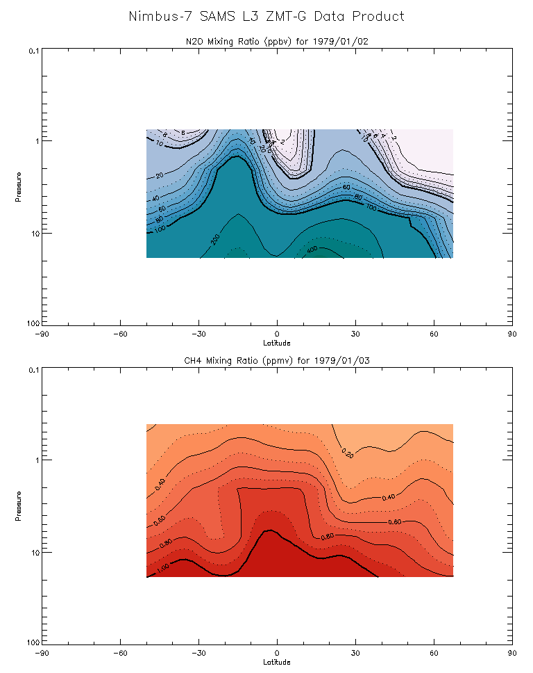
SAMS/Nimbus-7 Level 3 Zonal Means Composition Data V001 (SAMSN7L3ZMTG) at GES DISC
National Aeronautics and Space Administration —
SAMSN7L3ZMTG is the Nimbus-7 Stratospheric and Mesospheric Sounder (SAMS) Level 3 Zonal Means Composition Data Product. The Earth's surface is divided into 2.5-deg... -
Federal
TIROS-4 Medium-Resolution Scanning Radiometer Level 1 Final Meteorological Radiation Data V001 (TIROS4L1FMRT) at GES DISC
National Aeronautics and Space Administration —
TIROS-4 Medium-Resolution Scanning Radiometer Level 1 Final Meteorological Radiation Data (FMRT) product contains radiances expressed in five infrared/visible... -
Federal
TIROS-3 Medium-Resolution Scanning Radiometer Level 1 Final Meteorological Radiation Data V001 (TIROS3L1FMRT) at GES DISC
National Aeronautics and Space Administration —
TIROS-3 Medium-Resolution Scanning Radiometer Level 1 Final Meteorological Radiation Data (FMRT) product contains radiances expressed in five infrared/visible... -
Federal
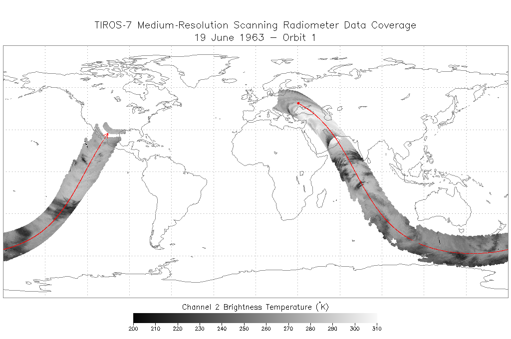
TIROS-7 Medium-Resolution Scanning Radiometer Level 1 Final Meteorological Radiation Data V001 (TIROS7L1FMRT) at GES DISC
National Aeronautics and Space Administration —
TIROS-7 Medium-Resolution Scanning Radiometer Level 1 Final Meteorological Radiation Data (FMRT) product contains radiances expressed in five infrared/visible... -
State
Los Angeles River Restoration and Access (LLARRA) Water Quality Analysis - Lower Los Angeles River - 2024-2025
State of California —
WCB Grant 2023114: Lower Los Angeles River Restoration and Access: Data includes one (1) year of water quality analysis to inform the design and serve as a baseline... -
Federal
BLM Natl WesternUS FIAT Project Planning Areas 2015 Polygon
Department of the Interior —
This data represents a management strategy of the Fire and Invasives Assessment Tool (FIAT). Project Planning Area (PPA) polygons are part of the FIAT Step 2 process.... -
Federal
VMS Groundfish 2010-2017 (BOEM)
Department of the Interior —
2010-2017 Vessel Monitoring System (VMS) data were used from the NOAA Office of Law Enforcement to create this fishing effort dataset for the U.S. West Coast. The... -
Federal
Generator Fleet Characteristics Model
Department of Commerce —
When run, the GFCM creates tabular and graphical data of the hourly operating status and market outcomes for the generators that make up the electric generating fleet. -
Federal
Sequence-based allelic variations and frequencies for 22 autosomal STR loci in the Lebanese population - Supplementary material
Department of Commerce —
This data repository is meant to provide the supplementary files, tables, and figures included in the peer-reviewed research article entitled: "Sequence-based allelic... -
Federal
Data for "Distributed contactless interconnects for millimeter-wave heterogeneous integration"
Department of Commerce —
Included here are figures and other relevant data from the paper "Distributed contactless interconnects for millimeter-wave heterogeneous integration", submitted to... -
Federal
GIAB Benchmarking of HG002 Assemblies from HPRC Year 1 Bakeoff
Department of Commerce —
The Human Pangenome Reference Consortium (HPRC) tested which combination of current genome sequencing and automated assembly approaches yields the most complete,...
1,569 datasets found for "bbin试玩✅澳门葡京赌场官方网站-网址【079.one】㊙️最火爆PG电子超高爆奖率,注册即送38元.CxdkhwqlMYmfsGW"