
-
Federal
GHRSST Level 2P NOAA ACSPO SST v2.80 from VIIRS on NOAA-21 Satellite
National Aeronautics and Space Administration —
The N21-VIIRS-L2P-ACSPO-v2.80 dataset produced by the NOAA ACSPO system derives the Subskin Sea Surface Temperature (SST) from the Visible Infrared Imaging Radiometer... -
Federal
GHRSST Level 3C Indian-Ocean (IO) sub-skin Sea Surface Temperature from the Spinning Enhanced Visible and Infrared Imager (SEVIRI) on MSG in GDS2 format produced by OSISAF
National Aeronautics and Space Administration —
This dataset is produced by the Ocean and Sea Ice Satellite Application Facility (OSI SAF) from the Spinning Enhanced Visible and InfraRed Imager (SEVIRI) instrument... -
Federal
GHRSST Level 3U Global Near-Real-Time Subskin Sea Surface Temperature version 8a from the Advanced Microwave Scanning Radiometer 2 on the GCOM-W satellite
National Aeronautics and Space Administration —
GDS2 Version -The Advanced Microwave Scanning Radiometer 2 (AMSR2) was launched on 18 May 2012, onboard the Golbal Change Observation Mission - Water (GCOM-W)... -
Federal
First ISCCP Regional Experiment (FIRE) Cirrus Phase II NCAR Kingair Aircraft Microphysical Data
National Aeronautics and Space Administration —
The First ISCCP Regional Experiments have been designed to improve data products and cloud/radiation parameterizations used in general circulation models (GCMs).... -
Federal
First ISCCP Regional Experiment (FIRE) Arctic Cloud Experiment (ACE) CV580 Aircraft G-Meter Data
National Aeronautics and Space Administration —
This data set consists of light scattering measurements provided by the 4-channel nephelometer g-meter instrument flown onboard the University of Washington's CV580... -
Federal
GPM DPR Ku Precipitation Profile 2A 1.5 hours 5 km V07 (GPM_2AKu) at GES DISC
National Aeronautics and Space Administration —
Version 07 is the current version of the data set. Older versions will no longer be available and have been superseded by Version 07. The 2AKu algorithm is a single-... -
Federal
Global Food Security-support Analysis Data (GFSAD) Cropland Extent 2010 North America product 30 m V001
National Aeronautics and Space Administration —
The NASA Making Earth System Data Records for Use in Research Environments (MEaSUREs) Global Food Security-support Analysis Data (GFSAD) data product provides... -
Federal
Global Fire carbon emissions from CMS-Flux inversions assimilating atmospheric carbon monoxide observations
National Aeronautics and Space Administration —
This dataset provides carbon monoxide and carbon dioxide flux from fires constrained by satellite observations.The NASA Carbon Monitoring System (CMS) is designed to... -
Federal
GPM GMI Antenna Temperatures L1BASE 1.5 hours 13 km V07 (GPM_BASEGPMGMI) at GES DISC
National Aeronautics and Space Administration —
Version 07 is the current version of the data set. Older versions are no longer available and have been superseded by the current version.GMI is a multi-channel,... -
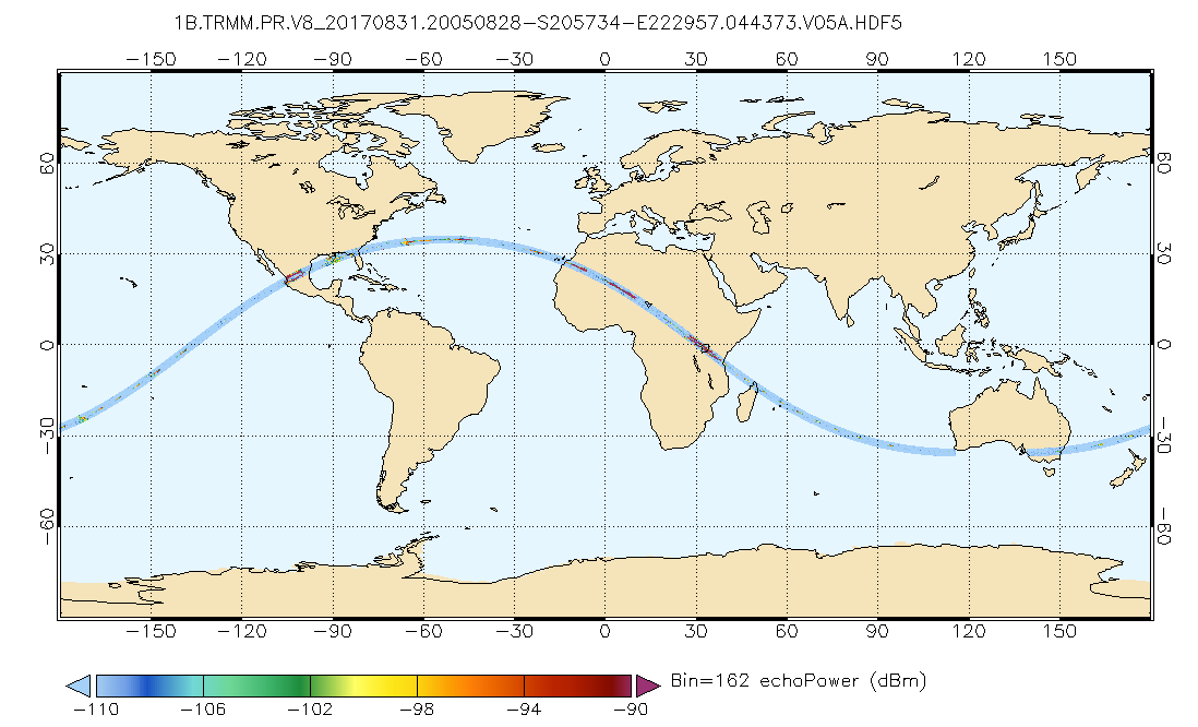
Federal
GPM PR on TRMM Echo Power L1B 1.5 hours 5 km V07 (GPM_1BPR) at GES DISC
National Aeronautics and Space Administration —
This is the new (GPM-formated) TRMM product. It replaces the old TRMM_1B21,1C21 Version 07 is the current version of the data set. Previous versions have been... -
Federal
FIREX-AQ DC-8 High-Spectral Resolution Lidar (HSRL) Remotely Sensed Data
National Aeronautics and Space Administration —
FIREXAQ_HSRL_AircraftRemoteSensing_DC8_Data are remotely sensed data collected by the High-Spectral Resolution Lidar (HSRL) onboard the DC-8 aircraft during FIREX-AQ.... -
Federal
Aquarius Official Release Level 3 Rain-flagged Sea Surface Salinity Smoothed Standard Mapped Image Monthly Data V5.0
National Aeronautics and Space Administration —
Aquarius Level 3 sea surface salinity (SSS) standard mapped image data contains gridded 1 degree spatial resolution SSS averaged over daily,7 day, monthly, and... -
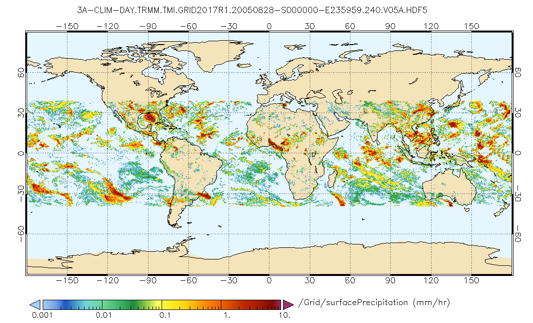
Federal
GPM TMI on TRMM (GPROF) Climate-based Radiometer Precipitation Profiling L3 1 day 0.25 degree x 0.25 degree V07 (GPM_3GPROFTRMMTMI_DAY_CLIM) at GES DISC
National Aeronautics and Space Administration —
This a new (GPM-formated) TRMM product. There is no equivalent in the old TRMM suite of products. Version 07 is the current version of the data set. Older versions... -
Federal
GPM VIRS on TRMM unpacked data L1A 1.5 hours 2 km V07 (GPM_1AVIRS) at GES DISC
National Aeronautics and Space Administration —
This is the new (GPM-formated) TRMM product. It replaces the old TRMM_1A01 Version 07 is the current version of the data set. Previous versions have been superseded... -
Federal
GPM SSM/I on F15 (GPROF) Climate-based Radiometer Precipitation Profiling L2 1.5 hours 12 km V07 (GPM_2AGPROFF15SSMI_CLIM) at GES DISC
National Aeronautics and Space Administration —
Version 07 is the current version of the data set. Older versions will no longer be available and have been superseded by Version 07.The 'CLIM' products differ from... -
Federal
FIREX-AQ DC-8 In-Situ Trace Gas Data
National Aeronautics and Space Administration —
FIREXAQ_TraceGas_AircraftInSitu_DC8_Data are in-situ trace gas measurements conducted onboard the DC8 aircraft during FIREX-AQ. This product features data collected... -
Federal
DISCOVER-AQ California Deployment Porterville Ground Site Data
National Aeronautics and Space Administration —
DISCOVERAQ_California_Ground_Porterville_Data contains data collected at the Porterville ground site during the California (San Joaquin Valley) deployment of NASA's... -
Federal
DISCOVER-AQ Colorado Deployment Ancillary Model Data
National Aeronautics and Space Administration —
DISCOVERAQ_Colorado_Model_Data contains ancillary model analysis collected during the Colorado (Denver) deployment of NASA's DISCOVER-AQ field study and features data... -
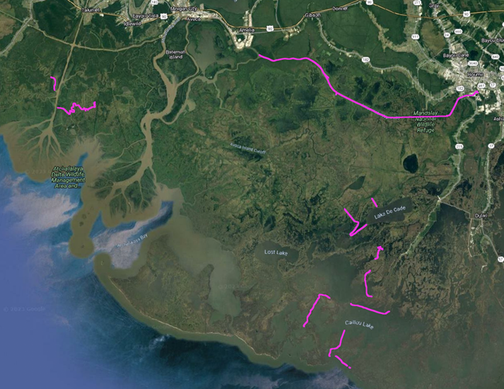
Federal
Delta-X: In-situ Water Surface Elevation, MRD, Louisiana, USA, 2021
National Aeronautics and Space Administration —
This dataset contains in situ water level measurements collected at 49 different locations across the Atchafalaya and Terrebonne basins in the Mississippi River Delta... -
Federal
CERES Clouds and Radiative Swath Aqua FM4 MODIS Edition2B
National Aeronautics and Space Administration —
CER_CRS_Aqua-FM4-MODIS_Edition2B is the Clouds and the Earth's Radiant Energy System (CERES) Clouds and Radiative Swath (CRS) Aqua-Flight Model 4 (FM4) Moderate-...

Official websites use .gov
A
.gov website belongs to an official government
organization in the United States.
Secure .gov websites use HTTPS
A
lock (
) or https:// means you’ve safely connected to
the .gov website. Share sensitive information only on official,
secure websites.