

1,939 datasets found for "Mining"
-
Federal
Minerals Yearbook, volume III, Area Reports — International: 2019 country chapters, table 1, production of mineral commodities
Department of the Interior —
This data release contains the compilation of country level mineral commodity production data extracted from Table 1 within all published 2019 international chapters... -
Federal
Crude Oil Analysis (COA) Database
Department of Energy —
The Crude Oil Analysis (COA) database contains the digital data compilation of 9,076 crude oil analyses from samples collected from 1920 through 1983 from the United... -
Federal
MSHA Inspections Dataset
Department of Labor —
Lists every mine inspection conducted by MSHA. Includes the name of the mine inspected, MSHA's internal inspection number (event number), the type of inspection and... -
Federal
Estimated Groundwater Withdrawals from Principal Aquifers in the United States—County Level Data for 2015
Department of the Interior —
This dataset contains estimates of water withdrawals from 66 principal aquifers and "other" non-principal aquifers during 2015 for various categories of use in each... -
Federal
BLM Natl MLRS Land Use Authorization- Rights of Way ROW
Department of the Interior —
This dataset contains land use authorization- rights-of-way cases derived from Legal Land Descriptions (LLD) contained in the US Bureau of Land Management's, BLM,... -
Federal
Porphyry copper deposits and prospects in the Andes Mountains of South America
Department of the Interior —
The Andes Mountains of South America host significant porphyry copper deposits. The region is the major global source of copper and an area of active mining,... -
Federal
MSHA Coal Employment & Fatality Statistics
Department of Labor —
Historical Data: 1900 - present. Number of Miners & Mining Fatalities - Coal -
State
Map and database of exploration drilling targets categorized by play type, North Slope and offshore Arctic Alaska
State of Alaska —
Miscellaneous Publication 167, Map and database of exploration drilling targets categorized by play type, North Slope and offshore Arctic Alaska, presents a... -
Federal
Dynamic, Graph-Based Risk Assessments for the Detection of Violent Extremist Radicalization Trajectories Using Large Scale Social and Behavioral Data, United States, Canada, United Kingdom, Germany, 1994-2020
Department of Justice —
This project examines the trajectory of radicalization of jihadists and Incels with two broad objectives in mind. First, to develop new integrated computational... -
Federal
Elk Creek Seismic Waveforms 2010 (Part 2 of 7)
U.S. Department of Health & Human Services —
Coal bursts (damaging seismic events in underground coal mines) pose a substantial threat to operations and mine workers. The underground coal mines in Colorado’s... -
State
Reconnaissance geologic maps and sample data, Teller A-1, A-2, A-3, B-1, B-2, B-3, C-1, and Bendeleben A-6, B-6, C-6, D-5, D-6 quadrangles, Seward Peninsula, Alaska
State of Alaska —
Reconnaissance geologic maps and sample data, Teller A-1, A-2, A-3, B-1, B-2, B-3, C-1, and Bendeleben A-6, B-6, C-6, D-5, D-6 quadrangles, Seward Peninsula, Alaska,... -
Federal
MSHA Noise Samples
Department of Labor —
Includes information about noise samples taken and the types of protection being used, the machines active and environment at the time. Form No. and Survey No.... -
Federal
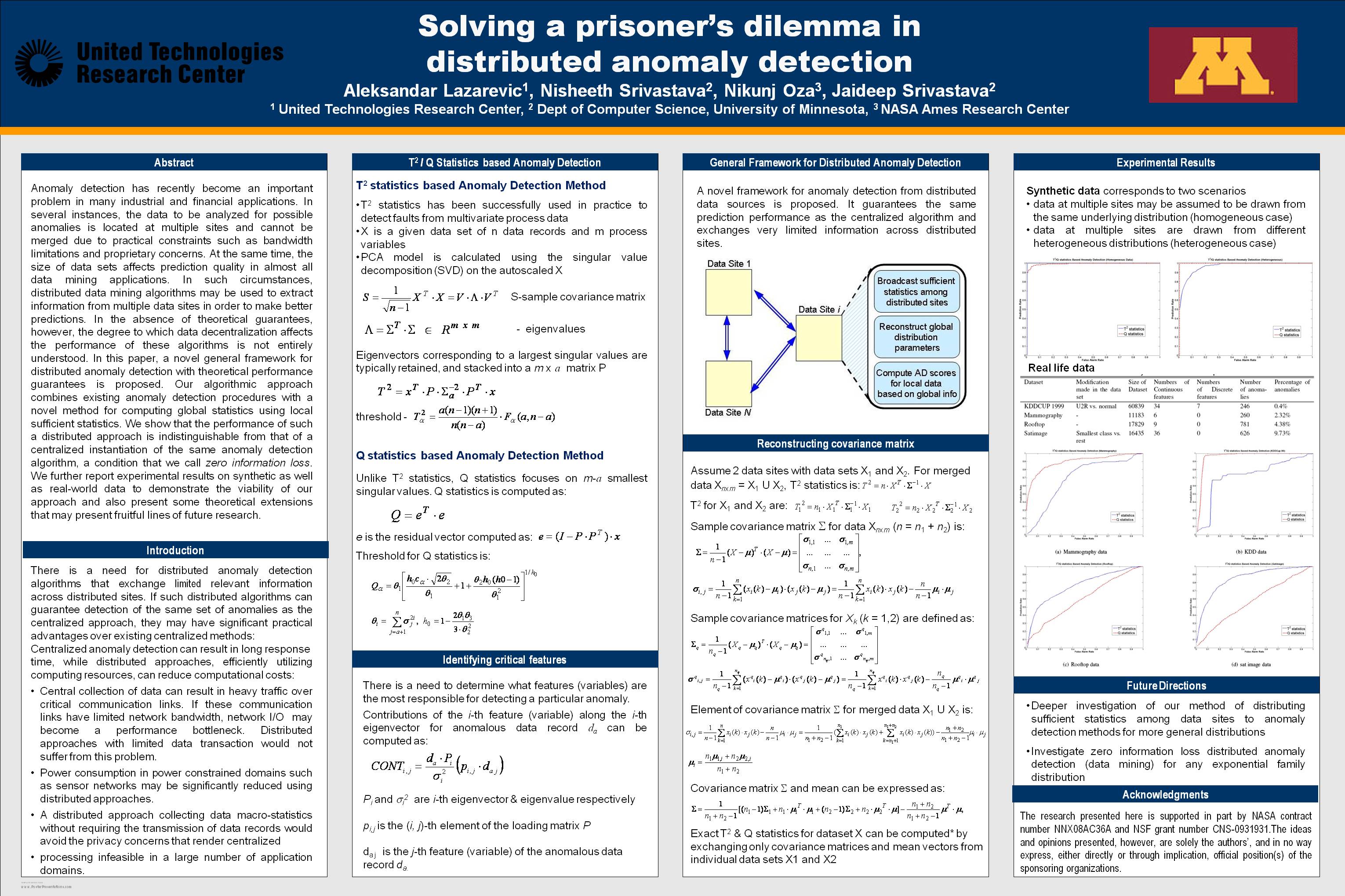
Solving a prisoner's dilemma in distributed anomaly detection
National Aeronautics and Space Administration —
Anomaly detection has recently become an important problem in many industrial and financial applications. In several instances, the data to be analyzed for possible... -
Federal
Beneficiaries of Oro Legal Activity in Colombia
US Agency for International Development —
Broad demographic and activity data on the beneficiaries of the USAID Artisanal Gold Mining - Environmental Impact Reduction Activity (known as "Oro Legal"), Contract... -
Federal
Tribal Administrative Boundary Polygon, Navajo Nation, 2015, U.S. EPA Region 9
U.S. Environmental Protection Agency —
This GIS dataset contains a polygon feature representing the administrative boundary of the Navajo Nation, inclusive of the eastern "checkerboard areas" that includes... -
Federal
DATA MINING THE GALAXY ZOO MERGERS
National Aeronautics and Space Administration —
DATA MINING THE GALAXY ZOO MERGERS STEVEN BAEHR, ARUN VEDACHALAM, KIRK BORNE, AND DANIEL SPONSELLER Abstract. Collisions between pairs of galaxies usually end in the... -
University
New Mexico Known Mineral Deposit Areas
Earth Data Analysis Center, University of New Mexico —
This dataset contains all Known Mineral Deposit Areas in the state of New Mexico. It is in a vector digital structure digitized from a 1:500,000 scale map of the... -
Federal
WaterTAP3 Model Results for NAWI's Baseline Analyses
Department of Energy —
This dataset contains the results for the WaterTAP3 model that was used for the eight NAWI (National Alliance for Water Innovation) baseline studies published in the...
1,939 datasets found for "Mining"