
-
Federal
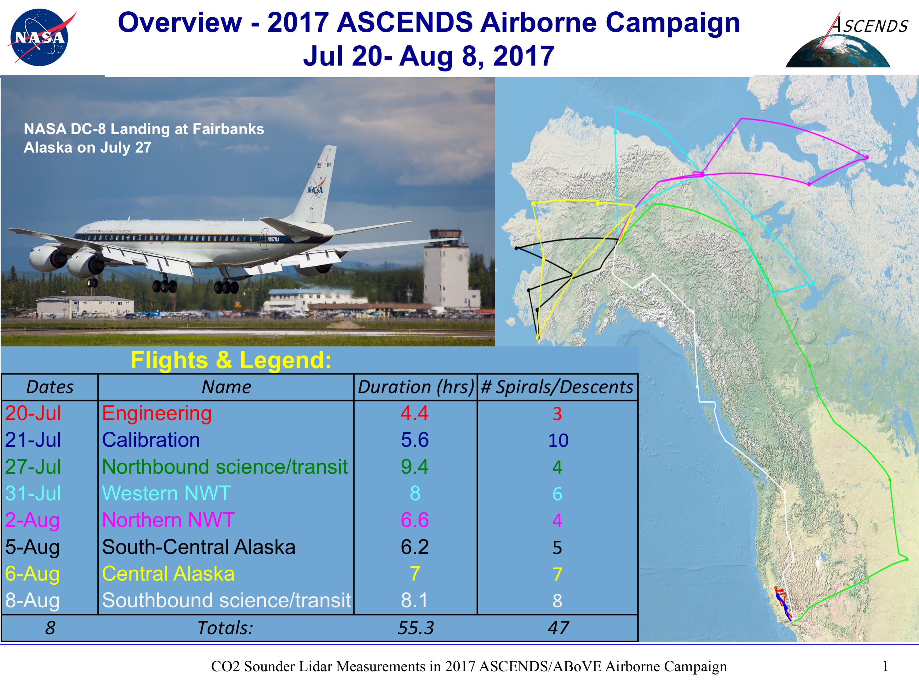
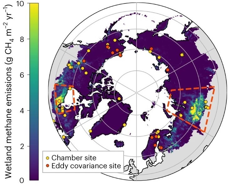
ABoVE/ASCENDS: Active Sensing of CO2, CH4, and Water Vapor, Alaska and Canada, 2017
National Aeronautics and Space Administration —
This dataset provides in situ airborne measurements of atmospheric carbon dioxide (CO2), methane (CH4), and water vapor concentrations, plus air temperature,... -
Federal
BOREAS TF-09 SSA-OBS Tower Flux, Meteorological, and Soil Temperature Data
National Aeronautics and Space Administration —
The BOREAS TF-09 team collected energy, carbon dioxide and water vapor flux data at the BOREAS SSA-OBS site during the growing season of 1994 and most of the year for... -
Federal
BOREAS Site and Area Geographic Coordinate Information
National Aeronautics and Space Administration —
In an effort to properly document the sites and areas where data were collected, personnel of the BOReal Ecosystem-Atmosphere Study (BOREAS) Information System... -
Federal
BOREAS HYD-01 Soil Hydraulic Properties
National Aeronautics and Space Administration —
The BOREAS HYD-01 team made several measurements related to soil moisture and soil properties. These soil hydraulic properties were determined at the flux tower sites... -
Federal
Biome-BGC: Modeling Carbon Dynamics in Ponderosa Pine Stands (Law et al. 2003)
National Aeronautics and Space Administration —
This archived model product contains the directions, executables, and procedures for running Biome-BGC, Version 4.1.2, to recreate the results of Law BE, Sun OJ,... -
Federal
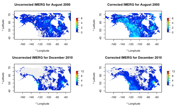
ABoVE: Bias-Corrected IMERG Monthly Precipitation for Alaska and Canada, 2000-2020
National Aeronautics and Space Administration —
This dataset is a modification to the Integrated Multi-satellitE Retrievals for GPM (IMERG) Final Run microwave-only, daily precipitation Version 06 data. It provides... -
Federal
ABoVE: Light-Curve Modelling of Gridded GPP Using MODIS MAIAC and Flux Tower Data
National Aeronautics and Space Administration —
This dataset contains gridded estimations of daily ecosystem Gross Primary Production (GPP) in grams of carbon per day at a 1 km2 spatial resolution over Alaska and... -
Federal
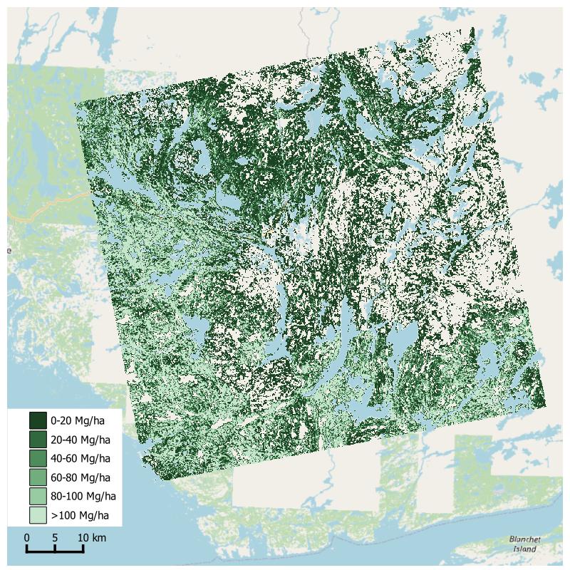
Aboveground Biomass from SAR, Great Slave Lake Region, NWT, 2019
National Aeronautics and Space Administration —
This dataset holds aboveground biomass (ABG) estimates for areas in the Great Slave Lake Region in the Northwest Territories of Canada for 2019. ABG was estimated... -
Federal
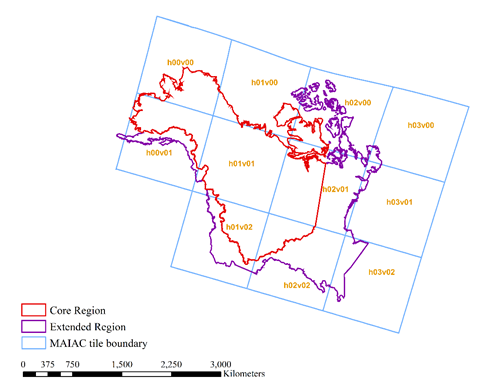
ABoVE: Angular-corrected MODIS MAIAC Reflectance across Alaska and Canada, 2000-2017
National Aeronautics and Space Administration —
This dataset provides angular corrections of MODIS Multi-Angle Implementation of Atmospheric Correction algorithm (MAIAC) surface reflectances across the ABoVE domain... -
Federal
BOREAS TGB-08 Starch Concentration Data over the SSA-OBS and the SSA-OJP
National Aeronautics and Space Administration —
The TGB-08 team collected data to investigate the controls over non-methane hydrocarbon (NMHC) fluxes from boreal forest tree species. This data set includes... -
Federal
BOREAS RSS-17 Stem, Soil, and Air Temperature Data
National Aeronautics and Space Administration —
The BOREAS RSS-17 team collected several data sets in support of its research in monitoring and analyzing environmental and phenological states using radar data. This... -
Federal
BOREAS RSS-03 Atmospheric Conditions from a Helicopter-Mounted Sunphotometer
National Aeronautics and Space Administration —
The BOREAS RSS-03 team collected and processed helicopter-based measurements of atmospheric conditions to estimates of aerosol optical thickness and atmospheric water... -
Federal
BOREAS RSS-01 PARABOLA SSA Surface Reflectance and Transmittance Data
National Aeronautics and Space Administration —
The BOREAS RSS-01 team collected surface reflectance and transmittance data from three forested sites in the SSA. This data set contains averaged reflectance factors... -
Federal
BOREAS TGB-12 Soil Carbon and Flux Data of NSA-MSA in Raster Format
National Aeronautics and Space Administration —
The BOREAS TGB-12 team made measurements of soil carbon inventories, carbon concentration in soil gases, and rates of soil respiration at several sites. This data set... -
Federal
Digital Elevation Models for the Global Change Research Wetland, Maryland, USA, 2016
National Aeronautics and Space Administration —
This dataset contains four alternative digital elevation models (DEMs) at 1 m resolution and model performance statistical metrics for the Global Change Research... -
Federal
Development and Evolution of NASA Satellite Remote Sensing for Ecology
National Aeronautics and Space Administration —
This dataset provides a presentation that highlights the role NASA research and researchers played in developing a wide range of significant, quantitative ecological... -
Federal
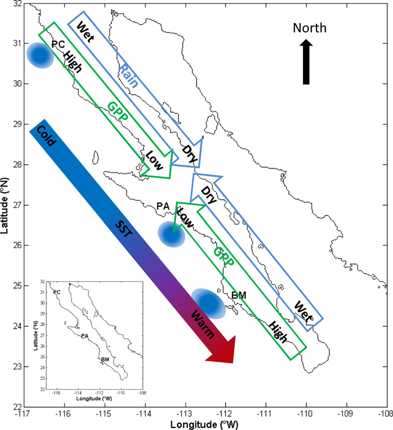
CMS: MODIS GPP, fPAR, and SST, and ENSO Index, Baja California, Mexico, 2000-2013
National Aeronautics and Space Administration —
This data set provides data for MODIS-derived (1) gross primary productivity (GPP) for the years 2000-2010, (2) fraction of photosynthetically active radiation (fPAR)... -
Federal
Arctic Vegetation Plots, Prudhoe Bay ArcSEES Road Study, Lake Colleen, Alaska, 2014
National Aeronautics and Space Administration —
This dataset provides environmental, soil, and vegetation data collected from study plots in the vicinity of Lake Colleen off the Spine Road at Prudhoe Bay, Alaska,... -
Federal
SAFARI 2000 TOMS Tropospheric Ozone Data, Southern Africa Subset, Dry Season 2000
National Aeronautics and Space Administration —
Tropical Tropospheric Ozone (TTO) data from Earth Probe (EP) Total Ozone Mapping Spectrometer (TOMS) for the period of August 8-September 29, 2000 were processed and...

Official websites use .gov
A
.gov website belongs to an official government
organization in the United States.
Secure .gov websites use HTTPS
A
lock (
) or https:// means you’ve safely connected to
the .gov website. Share sensitive information only on official,
secure websites.