
-
State
California School District Areas 2024-25
State of California —
This layer serves as the authoritative geographic data source for all school district area boundaries in California. School districts are single purpose governmental... -
Federal
Tropical Ozone Transport Experiment - Vortex Ozone Transport Experiment (TOTE-VOTE) Sonde Data
National Aeronautics and Space Administration —
TOTE-VOTE_Sondes_Data_1 is the radiosonde data collected during the Tropical Ozone Transport Experiment – Vortex Ozone Transport Experiment (TOTE-VOTE) campaign. Data... -
State
Chart 3.0.7 Total Number of Members who utilzed CS in the quarter 12-months prior to the last quarter of data
State of California —
ECM Community Support Services tables for a Quarterly Implementation Report. Including the County and Plan Details for both ECM and Community Support.This Medi-Cal... -
Federal
LBA-ECO LC-21 Soil Characteristics, Logged Areas, Tapajos Forest, Para, Brazil: 2003
National Aeronautics and Space Administration —
This data set provides measurements for soil nutrients from areas that were selectively logged and from control areas in the Tapajos National Forest, Para Western... -
Federal
LBA-ECO LC-04 THMB Model Simulations for the Amazon and Tocantins Basins: 1939-1998
National Aeronautics and Space Administration —
The model output data provided were generated by the THMB 1.2 (Terrestrial Hydrology Model with Biogeochemistry) model which simulates the flow of water through... -
Federal
LBA-ECO LC-01 Landsat MSS, TM, ETM+ Imagery, Northern Ecuadorian Amazon: 1973-2002
National Aeronautics and Space Administration —
This data set contains a time series of early Landsat-4 MSS satellite imagery as well as Landsat-5 TM and Landsat-7 ETM+ satellite imagery of the northern Ecuadorian... -
Federal
LBA-ECO CD-10 H2O Profiles at km 67 Tower Site, Tapajos National Forest
National Aeronautics and Space Administration —
This data set reports vertical profiles of H2O vapor concentrations measured at the Para Western (Santarem) - km 67, Primary Forest Tower Site (Figure 1). This site... -
Federal
LBA-ECO CD-10 Tree DBH Measurements at the km 67 Tower Site, Tapajos National Forest
National Aeronautics and Space Administration —
This data sets reports diameter at breast height (DBH) measurements in the old-growth upland forest at the Para Western (Santarem) - km 67, Primary Forest Tower Site.... -
Federal
LBA-ECO CD-06 CO2 Exchange in River Systems Across the Amazon Basin: 2004-2007
National Aeronautics and Space Administration —
This data set provides measurements of carbon dioxide flux rates (FCO2), gas transfer velocity (k), and partial pressures (pCO2) at 75 sites on rivers and streams of... -
Federal
LBA-ECO CD-02 Forest Canopy Structure, Tapajos National Forest, Brazil: 1999-2003
National Aeronautics and Space Administration —
This data set reports on Leaf Area Index (LAI) and Specific Leaf Area (SLA) measurements collected from forest and pasture sites in or near the Tapajos National... -
Federal
JERS-1 Synthetic Aperture Radar, 100-m Mosaics, South America: 1995-1996, R1
National Aeronautics and Space Administration —
This data set provides ~100-m resolution image mosaics of South America acquired during the low flood season between September and December 1995 and during the high... -
Federal
ISLSCP II Globalview: Atmospheric CO2 Concentrations
National Aeronautics and Space Administration —
The GlobalView Carbon Dioxide (CO2) data product contains synchronized and smoothed time series of atmospheric CO2 concentrations at selected sites that were created... -
Federal
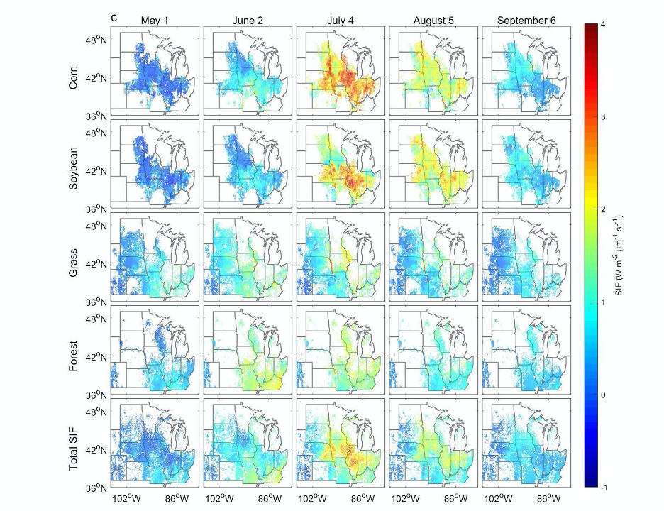
High Resolution Land Cover-Specific Solar-Induced Fluorescence, Midwestern USA, 2018
National Aeronautics and Space Administration —
This dataset provides estimated solar-induced chlorophyll fluorescence (SIF) of specific vegetation types and total SIF under clear-sky and real/cloudy conditions at... -
Federal
CARVE: L1 Daily Flight Path Geolocation and Aircraft Position Data, Alaska, 2012-2015
National Aeronautics and Space Administration —
This data set provides high-frequency geolocation, time, height, pitch, roll, and heading information for the C-23 Sherpa aircraft during airborne campaigns over the... -
Federal
BOREAS Follow-On MOD-01 Regional Daily Averaged Gridded Met. Data, 1994-1996
National Aeronautics and Space Administration —
The Phase 3 gridded data sets provided by HMet-01 on an hourly time step have been converted to averaged daily files by the MOD-01 group to reduce the size and number... -
Federal
BOREAS Follow-On DSP-01 Landsat TM Land Cover Mosaic of the BOREAS Transect
National Aeronautics and Space Administration —
The objective of this land cover mosaic is to provide a data product that characterises the detailed land cover of a significant portion of the BOREAS Region. Seven... -
Federal
BOREAS Agriculture Canada Central Saskatchewan Vector Soils Data, R1
National Aeronautics and Space Administration —
This data set provides soil descriptions for forested areas in the BOREAS southern study area (SSA) in central Saskatchewan, Canada provided by Agriculture Canada.... -
Federal
BOREAS HYD-04 Standard Snow Course Data
National Aeronautics and Space Administration —
The BOREAS HYD-04 work was focused on collecting data during the winter field campaign (FFC-W) to improve the understanding of winter processes within the boreal... -
Federal
Aquarius Official Release Level 3 Rain-flagged Sea Surface Salinity Standard Mapped Image Descending Monthly Climatology Data V5.0
National Aeronautics and Space Administration —
Aquarius Level 3 sea surface salinity (SSS) rain-flagged standard mapped image data contains gridded 1 degree spatial resolution SSS averaged over daily, 7 day,...

Official websites use .gov
A
.gov website belongs to an official government
organization in the United States.
Secure .gov websites use HTTPS
A
lock (
) or https:// means you’ve safely connected to
the .gov website. Share sensitive information only on official,
secure websites.