
-
Federal
CPEX-AW Dropsonde Data recent views
National Aeronautics and Space Administration —
CPEXAW-Dropsondes_1 is the dropsonde data files collected during the Convective Processes Experiment - Aerosols & Winds (CPEX-AW). Data collection for this... -
Federal
MODIS/Terra Temperature and Water Vapor Profiles 5-Min L2 Swath 5km - NRT NGDA recent views
National Aeronautics and Space Administration —
The level-2 MODIS Temperature and Water Vapor Profile Product MOD07_L2 consists of 30 gridded parameters related to atmospheric stability, atmospheric temperature and... -
Federal
GLDAS Catchment Land Surface Model L4 monthly 1.0 x 1.0 degree V2.0 (GLDAS_CLSM10_M) at GES DISC recent views
National Aeronautics and Space Administration —
NASA Global Land Data Assimilation System Version 2 (GLDAS-2) has three components: GLDAS-2.0, GLDAS-2.1, and GLDAS-2.2. GLDAS-2.0 is forced entirely with the... -
Federal
Bowen Ratio Surface Flux: Smith (FIFE) recent views
National Aeronautics and Space Administration —
Retrieval of surface fluxes from a combination of satellite & surface platforms -
Federal
TOVS GLA MONTHLY GRIDS from NOAA-10 V01 (TOVSAMNG) at GES DISC recent views
National Aeronautics and Space Administration —
This dataset (TOVSAMNG) contains the TIROS Operational Vertical Sounder (TOVS) level 3 geophysical parameters derived using data from NOAA-10 and the physical... -
Federal
MERRA-2 instU_2d_lfo_Nx: 2d,diurnal,Instantaneous,Single-Level,Assimilation,Land Surface Forcings 0.625 x 0.5 degree V5.12.4 (M2IUNXLFO) at GES DISC recent views
National Aeronautics and Space Administration —
M2IUNXLFO (or instU_2d_lfo_Nx) is an instantaneous 2-dimensional monthly diurnal means data collection in Modern-Era Retrospective analysis for Research and... -
Federal
NARSTO Pacific 2001 Air Quality Study (PAC2001) Golden Ears Gaseous and Particulate Matter (PM) Data recent views
National Aeronautics and Space Administration —
NARSTO_PAC2001_GOLDEN_EARS_GAS_PM_DATA is the North American Research Strategy for Tropospheric Ozone (NARSTO) Pacific 2001 Air Quality Study (PAC2001) Golden Ears... -
Federal
SAGE III/ISS L1B Monthly Solar Event Transmission Data (NetCDF) V052 recent views
National Aeronautics and Space Administration —
g3btmnc_52 is the Stratospheric Aerosol and Gas Experiment III (SAGE III) on the International Space Station (ISS) (SAGE III/ISS) Level 1 Monthly Solar Event Species... -
Federal
MERRA-2 tavgU_2d_slv_Nx: 2d,diurnal,Time-Averaged,Single-Level,Assimilation,Single-Level Diagnostics 0.625 x 0.5 degree V5.12.4 (M2TUNXSLV) at GES DISC recent views
National Aeronautics and Space Administration —
M2TUNXSLV (or tavgU_2d_slv_Nx) is a time-averaged 2-dimensional monthly diurnal means data collection in Modern-Era Retrospective analysis for Research and... -
Federal
Sounder SIPS: JPSS-1 CrIS Level 3 Specific Quality Control Gridded Monthly CLIMCAPS V2 (SNDRJ1IML3SMCCP) at GES DISC recent views
National Aeronautics and Space Administration —
WARNING: To users of the derived product “co_mmr_midtrop” (carbon monoxide mass mixing ratio to dry air [kg/kg] at ~500 hPa). This variable has a significant bias due... -
Federal
Pre-LBA Smoke, Clouds, and Radiation - Brazil (SCAR-B) Data recent views
National Aeronautics and Space Administration —
This data set contains meteorological data, reanalysis data, remote sensing images, and data on atmospheric composition collected during the Smoke, Clouds, and... -
Federal
Sounder SIPS: AQUA AIRS IR MW Level 3 CLIMCAPS : Specific Quality Control Gridded Daily V2 at GES DISC recent views
National Aeronautics and Space Administration —
WARNING: Users of the derived product “co_mmr_midtrop” (carbon monoxide mass mixing ratio to dry air [kg/kg] at ~500 hPa). This variable has a significant bias due to... -
Federal
GPM Ground Validation Upper Air Radiosonde LPVEx V1 recent views
National Aeronautics and Space Administration —
The GPM Ground Validation Radiosonde LPVEx dataset consists of sounding data collected as part of the Global Precipitation Measurement (GPM) mission Ground Validation... -
Federal
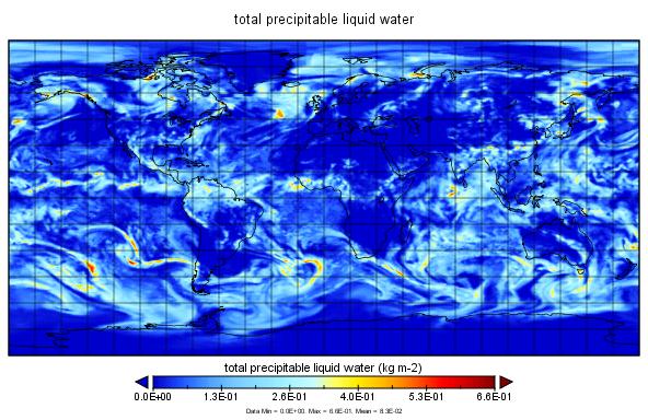
MERRA-2 inst1_2d_int_Nx: 2d,1-Hourly,Instantaneous,Single-Level,Assimilation,Vertically Integrated Diagnostics 0.625 x 0.5 degree V5.12.4 (M2I1NXINT) at GES DISC recent views
National Aeronautics and Space Administration —
M2I1NXINT (or inst1_2d_int_Nx) is an instantaneous 2-dimensional hourly data collection in Modern-Era Retrospective analysis for Research and Applications version 2... -
Federal
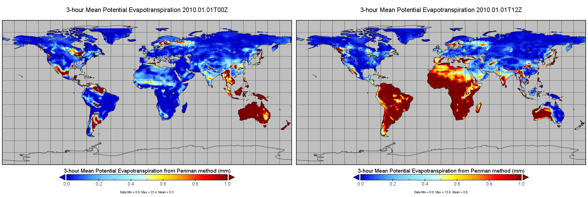
RM-OBS/PU Potential Evapotranspiration and Supporting Forcing L4 3-hourly 0.25x0.25 degree V002 (PET_PU_3H025) at GES DISC recent views
National Aeronautics and Space Administration —
This is version 2 of Princeton University MEaSUREs Potential Evapotranspiration (PET) dataset, which provides a set of estimates of PET based on near surface... -
Federal
Sounder SIPS: AQUA AIRS IR-only Level 3 CLIMCAPS: Specific Quality Control Gridded Daily V2 (SNDRAQIL3SDCCP) at GES DISC recent views
National Aeronautics and Space Administration —
WARNING: Users of the derived product “co_mmr_midtrop” (carbon monoxide mass mixing ratio to dry air [kg/kg] at ~500 hPa). This variable has a significant bias due to... -
Federal
Mid-Atlantic Network 2005-2023 Water Quality Data for Seven Park Projects as of 2024-02-08 recent views
Department of the Interior —
This data package was created 2024-03-12 15:16:59 by NPSTORET and includes selected project, location, and result data. Data contained in the Mid-Atlantic Network... -
Federal
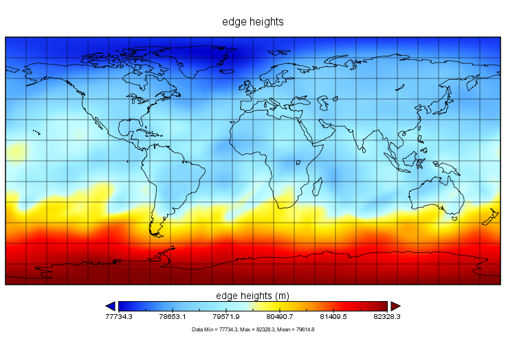
MERRA-2 tavg3_3d_nav_Ne: 3d,3-Hourly,Time-Averaged, Vertical Coordinates 0.625 x 0.5 degree V5.12.4 (M2T3NENAV) at GES DISC recent views
National Aeronautics and Space Administration —
M2T3NENAV (or tavg3_3d_nav_Ne) is a 3-dimensional 3-hourly time-averaged data collection in Modern-Era Retrospective analysis for Research and Applications version 2... -
Federal
First ISCCP Regional Experiment (FIRE) Cirrus Phase II National Weather Service(NWS) Outer-Network Rawinsonde Data recent views
National Aeronautics and Space Administration —
The First ISCCP Regional Experiments have been designed to improve data products and cloud/radiation parameterizations used in general circulation models (GCMs).... -
Federal
NLDAS Secondary Forcing Data L4 Monthly 0.125 x 0.125 degree V2.0 (NLDAS_FORB0125_M) at GES DISC recent views
National Aeronautics and Space Administration —
This data set contains the monthly secondary forcing data "File B" for Phase 2 of the North American Land Data Assimilation System (NLDAS-2). The data are in 1/8th...

Official websites use .gov
A
.gov website belongs to an official government
organization in the United States.
Secure .gov websites use HTTPS
A
lock (
) or https:// means you’ve safely connected to
the .gov website. Share sensitive information only on official,
secure websites.