
-
Federal
MODIS/Terra Gross Primary Productivity Gap-Filled 8-Day L4 Global 500m SIN Grid V006
National Aeronautics and Space Administration —
The MOD17A2HGF Version 6 data product was decommissioned on July 31, 2023. Users are encouraged to use theFederalMODIS/Terra+Aqua Land Cover Type Yearly L3 Global 500m SIN Grid V061
National Aeronautics and Space Administration —
The Terra and Aqua combined Moderate Resolution Imaging Spectroradiometer (MODIS) Land Cover Type (MCD12Q1) Version 6.1 data product provides global land cover types...FederalSWOT Sword of Science River Discharge Products Version 1
National Aeronautics and Space Administration —
The SWOT Sword of Science River Discharge Products dataset from the Surface Water and Ocean Topography (SWOT) mission and produced by the Discharge Algorithm Working...FederalIKONOS Level 1B Multispectral 4-Band Satellite Imagery
National Aeronautics and Space Administration —
The IKONOS Level 1B Multispectral 4-Band Imagery collection contains satellite imagery acquired from Maxar Technologies (formerly known as DigitalGlobe) by the...FederalWorldView-4 Level 1B Panchromatic Satellite Imagery
National Aeronautics and Space Administration —
The WorldView-4 Panchromatic Imagery collection contains satellite imagery acquired from Maxar Technologies (formerly known as DigitalGlobe) by the Commercial...FederalGlobal Maps of Atmospheric Nitrogen Deposition, 1860, 1993, and 2050
National Aeronautics and Space Administration —
This data set provides global gridded estimates of atmospheric deposition of total inorganic nitrogen (N), NHx (NH3 and NH4+), and NOy (all oxidized forms of nitrogen...FederalDaymet: Daily Surface Weather Data on a 1-km Grid for North America, Version 4 R1
National Aeronautics and Space Administration —
This dataset provides Daymet Version 4 R1 data as gridded estimates of daily weather parameters for North America, Hawaii, and Puerto Rico. Daymet variables include...FederalARISE C-130 Aircraft Merge Data Files
National Aeronautics and Space Administration —
ARISE_Merge_Data_1 is the Arctic Radiation - IceBridge Sea & Ice Experiment (ARISE) 2014 pre-generated aircraft (C-130) merge data files. This product is a result...FederalECOSTRESS Evaporative Stress Index dis-ALEXI USDA Daily L4 Global 30m V001
National Aeronautics and Space Administration —
The ECOsystem Spaceborne Thermal Radiometer Experiment on Space Station (ECOSTRESS) mission measures the temperature of plants to better understand how much water...FederalECCO Ocean Three-Dimensional Volume Fluxes - Monthly Mean llc90 Grid (Version 4 Release 4)
National Aeronautics and Space Administration —
This dataset provides monthly-averaged ocean three-dimensional volume fluxes on the native Lat-Lon-Cap 90 (LLC90) model grid from the ECCO Version 4 Release 4 (V4r4)...FederalHAQAST Sentinel-5P TROPOMI Nitrogen Dioxide (NO2) GLOBAL Annual Level 3 0.1 x 0.1 Degree Gridded Data Version 2.4 (HAQ_TROPOMI_NO2_GLOBAL_A_L3) at GES DISC
National Aeronautics and Space Administration —
This product provides level 3 annual averages of tropospheric Nitrogen dioxide (NO2) vertical column density derived from the level 2 Tropospheric Monitoring...FederalNACP Regional: National Greenhouse Gas Inventories and Aggregated Gridded Model Data
National Aeronautics and Space Administration —
This data set provides two products that were derived from the recently published North American Carbon Program (NACP) Regional Synthesis 1-degree terrestrial...FederalArctic Ice Dynamics Joint Experiment (AIDJEX) Second Pilot Study, March - May 1972: A Documentary Film, Version 1
National Aeronautics and Space Administration —
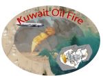
The project described in this documentary was a pilot study conducted in 1972 in preparation for the AIDJEX main experiment of 1975 to 1976. The study included a main...FederalCAR Kuwait Oil Fire Spectral Reflectance L1 V1 (CAR_KUWAITOILFIRE_L1C) at GES DISC
National Aeronautics and Space Administration —
CAR Kuwait Oil Fire mission measured bidirectional reflectance function of smoke from Kuwait oil fires during the Kuwait Oil Fire Smoke Experiment. Measurements were...FederalPlanetScope Satellite Imagery 3 Band Scene
National Aeronautics and Space Administration —
The Planet Scope 3 band collection contains satellite imagery obtained from Planet Labs, Inc by the Commercial SmallSat Data Acquisition (CSDA) Program. This...FederalATom: Merged Atmospheric Chemistry, Trace Gases, and Aerosols
National Aeronautics and Space Administration —
This dataset provides information on greenhouse gases and human-produced air pollution, including atmospheric concentrations of carbon dioxide (CO2), methane (CH4),...FederalRLC State and Regional Boundaries for the Former Soviet Union
National Aeronautics and Space Administration —
This data set of state and regional boundaries was derived from the 1:3 million scale administrative boundaries (ESRI, 1998) for the land area of the Former Soviet...FederalSentinel-1C Single Polarization Full Resolution Ground Range Detected Product Metadata
National Aeronautics and Space Administration —
The Sentinel-1C satellite was launched December 5, 2024. Sentinel-1C is the the latest satellite to be added to the Sentinel-1 constellation. The Sentinel-1...FederalGPM Ground Validation Global Flood Monitoring System (GFMS) Flood Maps IFloodS V1
National Aeronautics and Space Administration —
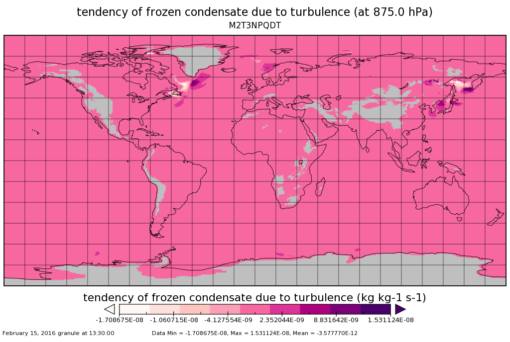
The GPM Ground Validation Global Flood Monitoring System (GFMS) Flood Maps IFloodS dataset contains global flood estimates on a 0.25 degree spatial resolution every 3...FederalMERRA-2 tavg3_3d_qdt_Np: 3d,3-Hourly,Time-Averaged,Pressure-Level,Assimilation,Moist Tendencies 0.625 x 0.5 degree V5.12.4 (M2T3NPQDT) at GES DISC
National Aeronautics and Space Administration —
M2T3NPQDT (or tavg3_3d_qdt_Np) is a 3-dimensional 3-hourly time averaged data collection in Modern-Era Retrospective analysis for Research and Applications version 2...9,584 datasets found

Official websites use .gov
A
.gov website belongs to an official government
organization in the United States.
Secure .gov websites use HTTPS
A
lock (
) or https:// means you’ve safely connected to
the .gov website. Share sensitive information only on official,
secure websites.