
-
Federal
China Dimensions Data Collection: China County-Level Data from Provincial Economic Yearbooks, Keyed to 1:1M GIS Map
National Aeronautics and Space Administration —
The China County-Level Data on Provincial Economic Yearbooks, Keyed To 1:1M GIS Map consists of socioeconomic and boundary data for the administrative regions of... -
Federal
Global Human Built-up And Settlement Extent (HBASE) Dataset From Landsat
National Aeronautics and Space Administration —
The Global Human Built-up And Settlement Extent (HBASE) Dataset from Landsat is a global map of HBASE derived from the Global Land Survey (GLS) Landsat dataset for... -
Federal
HANPP Collection: Global Patterns in Human Appropriation of Net Primary Productivity (HANPP)
National Aeronautics and Space Administration —
The HANPP Collection: Global Patterns in Human Appropriation of Net Primary Productivity (HANPP) represents a digital map of human appropriation of net primary... -
Federal
Global One-Eighth Degree Population Base Year and Projection Grids Based on the Shared Socioeconomic Pathways, Revision 01
National Aeronautics and Space Administration —
The Global One-Eighth Degree Population Base Year and Projection Grids Based on the Shared Socioeconomic Pathways, Revision 01, data set consists of global urban,... -
Federal
42012 - Orange Beach AL Buoy
National Oceanic and Atmospheric Administration, Department of Commerce —
GCOOS 52North Sensor Observation Service This station provides the following variables: Air pressure, Air temperature, Sea water temperature, Wind speed, Wind speed... -
Federal
West Africa Coastal Vulnerability Mapping: Social Vulnerability Indices
National Aeronautics and Space Administration —
The West Africa Coastal Vulnerability Mapping: Social Vulnerability Indices data set includes three indices: Social Vulnerability, Population Exposure, and Poverty... -
Federal
Vegetation Index and Phenology (VIP) Phenology EVI-2 Yearly Global 0.05Deg CMG V004
National Aeronautics and Space Administration —
The NASA Making Earth System Data Records for Use in Research Environments (MEaSUREs) Vegetation Index and Phenology (VIP) global datasets were created using surface... -
Federal
Community Geothermal: Soil Conductivity, Borehole Design, Energy Models, and Load Data for a Residential System Development - Hinesburg, VT
Department of Energy —
This dataset contains materials from the Coalition for Community-Supported Affordable Geothermal Energy Systems (C2SAGES) project, which evaluated the techno-economic... -
Federal
SWOT Level 2 Water Mask Raster Image 100m Data Product, Version 2.0
National Aeronautics and Space Administration —
The SWOT Level 2 Water Mask Raster Image 100m Data Product from the Surface Water Ocean Topography (SWOT) mission provides global surface water elevation and... -
Federal
Data and code from: AI-based image profiling and detection for the beetle byte quintet using Vision Transformer (ViT) in advanced stored product infestation monitoring
Department of Agriculture —
Managing beetles that infest stored products is crucial for reducing losses in harvest supply chains and improving food security and safety. Successful pest... -
Federal
China Dimensions Data Collection: Fundamental GIS: Digital Chart of China, 1:1M, Version 1
National Aeronautics and Space Administration —
The Fundamental GIS: Digital Chart of China, 1:1M, Version 1 consists of vector maps of China and surrounding areas. The maps include roads, railroads, drainage... -
Federal
HLS Landsat Operational Land Imager Surface Reflectance and TOA Brightness Daily Global 30m v2.0
National Aeronautics and Space Administration —
The Harmonized Landsat Sentinel-2 (HLS) project provides consistent surface reflectance (SR) and top of atmosphere (TOA) brightness data from a virtual constellation... -
Federal
Georeferenced Population Datasets of Mexico (GEO-MEX): Population Database of Mexico
National Aeronautics and Space Administration —
The Population Database of Mexico contains geographically referenced population data for Mexican states, municipalities and localities from the 1990 Mexican... -
Federal
Process-structure-properties investigations for laser powder bed fused IN718 in the as-built condition
National Institute of Standards and Technology —
This data repository provides a central location for a body of work using one build of nickel-based alloy 718 (IN718) material and resulted in three different... -
Federal
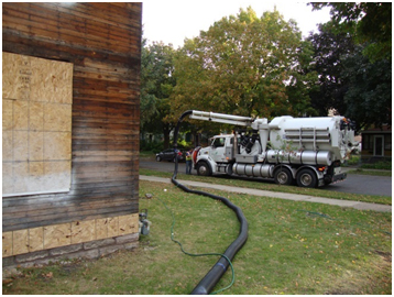
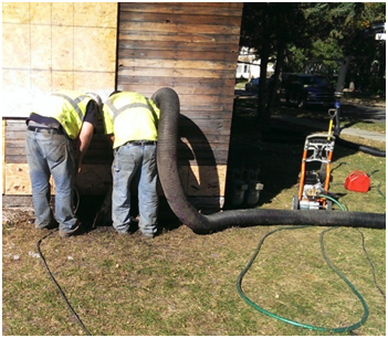
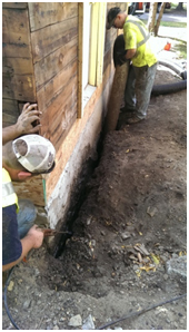
Excavationless Exterior Foundation Insulation Field Study - Minnesota
Department of Energy —
The NorthernSTAR Building America Partnership team implemented an innovative, minimally invasive foundation insulation upgrade technique on an existing home. The... -
Federal
SDG Indicator 11.2.1: Urban Access to Public Transport, 2023 Release
National Aeronautics and Space Administration —
The SDG Indicator 11.2.1: Urban Access to Public Transport, 2023 Release, part of the SDGI collection, measures the proportion of the population in a city that has... -
Federal
CYGNSS Level 1 Raw Intermediate Frequency Data Record
National Aeronautics and Space Administration —
This Level 1 (L1) dataset contains the Raw Intermediate Frequency (IF) sensor data from the Delay Doppler Mapping Instrument aboard the CYGNSS satellite... -
Federal
Effects of Climate Change on Global Food Production from SRES Emissions and Socioeconomic Scenarios
National Aeronautics and Space Administration —
The Effects of Climate Change on Global Food Production from SRES Emissions and Socioeconomic Scenarios is an update to a major crop modeling study by the NASA... -
Federal
SDG Indicator 11.7.1: Urban Public Space, Availability and Access, 2023 Release
National Aeronautics and Space Administration —
The SDG Indicator 11.7.1: Urban Public Space, Availability and Access, 2023 Release, part of the SDGI collection, measures the average share of the built-up area of a... -
Federal
ECOSTRESS Evapotranspiration dis-ALEXI USDA Daily L3 Global 30m V001
National Aeronautics and Space Administration —
The ECOsystem Spaceborne Thermal Radiometer Experiment on Space Station (ECOSTRESS) mission measures the temperature of plants to better understand how much water...

Official websites use .gov
A
.gov website belongs to an official government
organization in the United States.
Secure .gov websites use HTTPS
A
lock (
) or https:// means you’ve safely connected to
the .gov website. Share sensitive information only on official,
secure websites.