
-
Federal
Aircraft Flux-Detrended: Univ. Col. (FIFE)
National Aeronautics and Space Administration —
The NCAR King Air participation in FIFE-1987 and FIFE-1989 was part of a coordinated atmospheric boundary layer component which included other aircraft, surface... -
Federal
TROPESS Chemical Reanalysis Surface PAN 2-Hourly 2-dimensional Product V1 (TRPSCRPAN2H2D) at GES DISC
National Aeronautics and Space Administration —
The TROPESS Chemical Reanalysis PAN 2-Hourly 2-dimensional Product contains surface concentrations of peryoxyacetyl nitrate. The data are part of the Tropospheric... -
Federal
TROPESS CrIS-SNPP L2 Peroxyacetyl Nitrate for Forward Stream, Summary Product V1 (TRPSYL2PANCRSFS) at GES DISC
National Aeronautics and Space Administration —
The TROPESS CrIS-SNPP L2 Peroxyacetyl Nitrate for Forward Stream, Summary Product contains the vertical distribution of the retrieved atmospheric state of... -
Federal
Data from: Quantification and diagnostic relevance of blood and heme-mediated inhibition of prion detection by RT-QuIC
Department of Agriculture —
Purpose of the study:The mechanisms of inhibition mediated by heme on the prion protein misfolding reaction and detection of scrapie prions by the real-time quaking-... -
Federal
CERES Single Scanner Footprint (SSF) TOA/Surface Fluxes, Clouds and Aerosols TRMM-PFM Edition2B
National Aeronautics and Space Administration —
CER_SSF_TRMM-PFM-VIRS_Edition2B is the Clouds and the Earth's Radiant Energy System (CERES) Scanner Footprint (SSF) Top-of-Atmosphere (TOA)/Surface Fluxes, Clouds,... -
Federal
Fast Longwave And SHortwave Fluxes (FLASHflux) Clouds and Radiative Swath (SSF) TERRA-FM1 data in netCDF Version 4B
National Aeronautics and Space Administration —
FLASH_SSF_Terra-FM1-MODIS_Version4B is the Fast Longwave And Shortwave Radiative Fluxes (FLASHFlux) Clouds and Radiative Swath (SSF) TERRA-FM1 data in netCDF Version... -
Federal
Optical scattering measurements and simulation data for one-dimensional (1-D) patterned periodic sub-wavelength features
National Institute of Standards and Technology —
This data set consists of both measured and simulated optical intensities scattered off periodic line arrays, with simulations based upon an average geometric model... -
Federal
Sounder SIPS: Suomi NPP CrIMSS Level 3 Comprehensive Quality Control Gridded Monthly CLIMCAPS Full Spectral Resolution V2 at GES DISC
National Aeronautics and Space Administration —
WARNING: To users of the derived product “co_mmr_midtrop” (carbon monoxide mass mixing ratio to dry air [kg/kg] at ~500 hPa). This variable has a significant bias due... -
Federal
GPM GROUND VALIDATION DC-8 CAMERA NADIR GCPEX V1
National Aeronautics and Space Administration —
The GPM Ground Validation DC-8 Camera Nadir GCPEx dataset contains geo-located, visible-wavelength imagery of the ground obtained from the nadir camera aboard the... -
Federal
NOAA/WDS Paleoclimatology - Brown fire data from Archuleta Mesa Plot A1 - IMPD USACH003
National Oceanic and Atmospheric Administration, Department of Commerce —
This archived Paleoclimatology Study is available from the NOAA National Centers for Environmental Information (NCEI), under the World Data Service (WDS) for... -
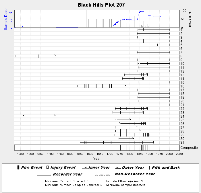
Federal
NOAA/WDS Paleoclimatology - Brown fire data from Black Hills Plot 207 - IMPD US207001
National Oceanic and Atmospheric Administration, Department of Commerce —
This archived Paleoclimatology Study is available from the NOAA National Centers for Environmental Information (NCEI), under the World Data Service (WDS) for... -
Federal
TIROS-4 Medium-Resolution Scanning Radiometer Level 1 Final Meteorological Radiation Data V001 (TIROS4L1FMRT) at GES DISC
National Aeronautics and Space Administration —
TIROS-4 Medium-Resolution Scanning Radiometer Level 1 Final Meteorological Radiation Data (FMRT) product contains radiances expressed in five infrared/visible... -
Federal
SAFARI 2000 Woody Vegetation Characteristics of Kalahari and Skukuza Sites
National Aeronautics and Space Administration —
This data set contains species composition, basal area, height, and crown cover of all woody plants at six sites along the Kalahari Transect visited in February-March... -
Federal
TROPESS CrIS-SNPP L2 Methane for Reanalysis Stream, Summary Product V1 (TRPSYL2CH4CRSRS) at GES DISC
National Aeronautics and Space Administration —
The TROPESS CrIS-SNPP L2 Methane for Reanalysis Stream, Summary Product contains the vertical distribution of the retrieved atmospheric state of methane (CH4), and... -
Federal
GPM ATMS on NOAA-20 (GPROF) Radiometer Precipitation Profiling L2A 1.5 hours 17 km V07 (GPM_2AGPROFNOAA20ATMS) at GES DISC
National Aeronautics and Space Administration —
Version 07 is the current version of the data set. The 2AGPROF (also known as, GPM GPROF (Level 2)) algorithm retrieves consistent precipitation and related science... -
Federal
LBA-ECO ND-11 Forest Soil Structure and Nitrate, NW Mato Grosso, Brazil: 2004-2005
National Aeronautics and Space Administration —
This data set reports the results of the analysis of soil samples for Nitrate (NO3) and physical properties that were collected for one year following reduced impact... -
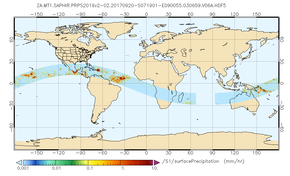
Federal
GPM SAPHIR on MT1 (PRPS) Radiometer Precipitation Profiling L2 1.5 hours 10 km V06 (GPM_2APRPSMT1SAPHIR) at GES DISC
National Aeronautics and Space Administration —
Version 6 is the current version of this dataset. Older versions are no longer available and have been superseded by Version 6.The Precipitation Retrieval and... -
Federal
LBA-ECO CD-10 Ground-based Biometry Data at km 67 Tower Site, Tapajos National Forest
National Aeronautics and Space Administration —
This data sets reports biometry measurements of the old-growth upland forest at the Para¡ Western (Santarrem)km 67, Primary Forest Tower Site. This site is in the... -
Federal
BOREAS TE-22 Tree Ring Data
National Aeronautics and Space Administration —
The BOREAS TE-22 team collected complete tree cores at several sites in the SSA and NSA in order to perform historical growth studies and relate the information to...

Official websites use .gov
A
.gov website belongs to an official government
organization in the United States.
Secure .gov websites use HTTPS
A
lock (
) or https:// means you’ve safely connected to
the .gov website. Share sensitive information only on official,
secure websites.