
-
Federal
Grass-Cast Database - Data on aboveground net primary productivity (ANPP), climate data, NDVI, and cattle weight gain for Western U.S. rangelands
Department of Agriculture —
Grass-Cast: Experimental Grassland Productivity Forecast for the Great Plains Grass-Cast uses almost 40 years of historical data on weather and vegetation growth in... -
Federal
CHIRPS Version 2.0, Precipitation, Global, 0.05°, Monthly, 1981-present, Lon0360
National Oceanic and Atmospheric Administration, Department of Commerce —
This dataset has monthly averages of the Climate Hazards Group InfraRed Precipitation with Station data (CHIRPS), which is quasi-global rainfall data set. Spanning... -
State
California Tree Mortality Viewer
State of California —
Five long years of drought, combined with the increased infestation of native bark beetles as a result of the drought, have contributed to the death of millions of... -
Federal
Global Drought Total Economic Loss Risk Deciles
National Aeronautics and Space Administration —
The Global Drought Total Economic Loss Risk Deciles is a 2.5 minute grid of global drought total economic loss risks. A process of spatially allocating Gross Domestic... -
Federal
CHIRPS Version 2.0, Precipitation, Global, 0.05°, Annual, 1981-present, Lon0360
National Oceanic and Atmospheric Administration, Department of Commerce —
This dataset has annual averages of the Climate Hazards Group InfraRed Precipitation with Station data (CHIRPS), which is quasi-global rainfall data set. Spanning... -
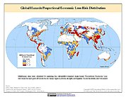
Federal
Global Multihazard Proportional Economic Loss Risk Deciles
National Aeronautics and Space Administration —
The Global Multihazard Proportional Economic Loss Risks is a 2.5 minute grid of a multihazard-based economic loss risk as a proportion of the economic productivity of... -
Federal
LBA-ECO ND-02 Soil Gas Flux, Rainfall Exclusion, km 67, Tapajos National Forest
National Aeronautics and Space Administration —
Moist tropical forests in Amazonia and elsewhere are subjected to increasingly severe drought episodes through the El Nino-Southern Oscillation (ENSO) and possibly... -
Federal
NPP Tropical Forest: Cinnamon Bay, U.S. Virgin Islands, 1982-1993, R1
National Aeronautics and Space Administration —
This data set contains three ASCII files (.txt format). One data file contains above-ground biomass, litter, litterfall, herbivory, biomass change, and above-ground... -
State
Watershed Restoration Grant Awards - CDFW [ds2663]
State of California —
PROPOSITION 1 GRANTS The Water Quality, Supply, and Infrastructure Improvement Act of 2014 (Proposition 1) provides funding to implement the three broad objectives of... -
Federal
Productivity of U.S. Rangelands, Annual Data lbs/acre
Department of Agriculture —
Production data were generated using the Normalized Difference Vegetation Index (NDVI) from the Thematic Mapper Suite from 1984 to 2023 at 250 m resolution. The NDVI... -
Federal
Productivity of U.S. Rangelands, Annual Data lbs/acre (Map Service)
Department of Agriculture —
Production data were generated using the Normalized Difference Vegetation Index (NDVI) from the Thematic Mapper Suite from 1984 to 2021 at 250 m resolution. The NDVI... -
State
Indicators of Climate Change in California
State of California —
An introduction to the 2022 Indicators of Climate Change in California Report. The Indicators of Climate Change in California report documents observed changes in the... -
Federal
Climate Change Pressures Plant Hardiness Zones (Map Service)
Department of Agriculture —
Evaluating multiple signals of climate change across the conterminous United States during three 30-year periods (2010�2039, 2040�2069, 2070�2099) during this century... -
Federal
Vegetation Drought Response Index (VegDRI)
National Aeronautics and Space Administration —
The National Drought Mitigation Center produces VegDRI in collaboration with the US Geological Survey's (USGS) Center for Earth Resources Observation and Science... -
Federal
UAVSAR_POLSAR_ML_COMPLEX_SLANT
National Aeronautics and Space Administration —
UAVSAR PolSAR Scene Complex -
Federal
UAVSAR_POLSAR_ML_COMPLEX_GRD
National Aeronautics and Space Administration —
UAVSAR PolSAR Scene Projected -
Federal
CHIRPS Version 2.0, Precipitation, Global, 0.05°, 5-Day, 1981-present
National Oceanic and Atmospheric Administration, Department of Commerce —
This dataset has 5-day (pentad) averages of the Climate Hazards Group InfraRed Precipitation with Station data (CHIRPS), which is quasi-global rainfall data set.... -
Federal
Drought and Moisture Surplus for the Conterminous United States, Annual Data 1-Year Windows (Image Service)
Department of Agriculture —
Note: To download this raster dataset, go to ArcGIS Open Data Set and click the download button, and under additional resources select raster download option; the... -
Federal
Drought and Moisture Surplus for the Conterminous United States, Annual Data 5-Year Windows (Image Service)
Department of Agriculture —
Note: To download this raster dataset, go to ArcGIS Open Data Set and click the download button, and under additional resources select raster download option; the...

Official websites use .gov
A
.gov website belongs to an official government
organization in the United States.
Secure .gov websites use HTTPS
A
lock (
) or https:// means you’ve safely connected to
the .gov website. Share sensitive information only on official,
secure websites.